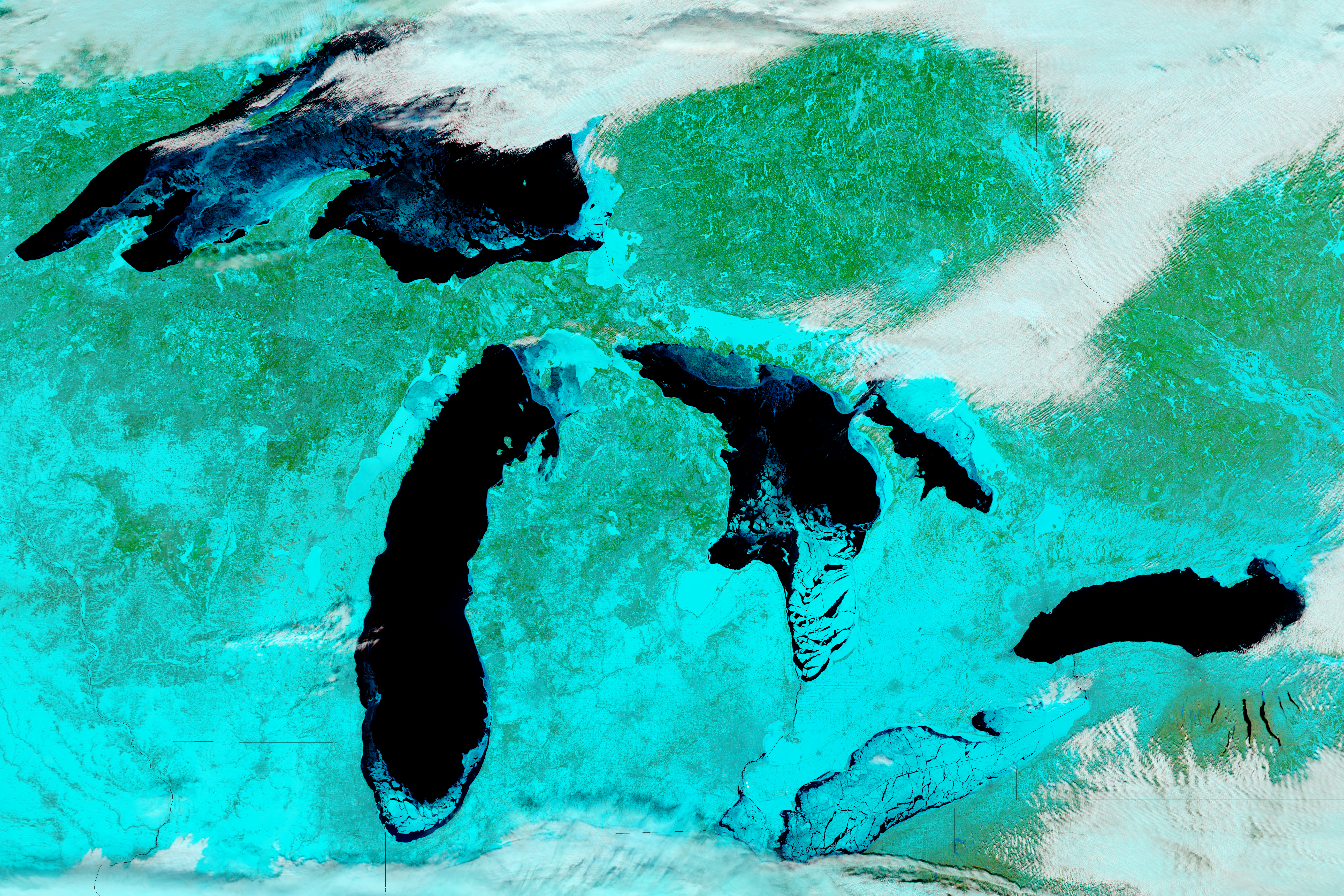
The unusually cold winter in the Upper Midwest has led to a notable buildup of ice on the Great Lakes. Lake Erie is usually the first to freeze over because it is shallower than the other Great Lakes.

 download large image (19 MB, JPEG, 5200×3467)
On February 14, 2018, the Moderate Resolution Imaging Spectroradiometer (MODIS) on NASA’s Aqua satellite acquired data for these false-color images of North America’s Great Lakes. The images were made from a combination of infrared and visible light (MODIS bands 7-2-1) in order to better differentiate between snow and ice (teal) and clouds (white). Open water appears black, though some of the dark areas likely have a layer of clear ice (without snow cover on it). For a detailed map of ice extent and thickness on the Great Lakes, visit the Great Lakes Ice Analysis page.
When these data were acquired, 57.9 percent of the surfaces of the Great Lakes were covered with ice, according to NOAA’s Great Lakes Environmental Research Laboratory. On the same date last year, total ice cover was 9.7 percent. Lake Erie was the iciest of the five lakes, with 93.3 percent iced over.
Lake Erie is slightly larger in surface area than Lake Ontario (the smallest of the five Great Lakes), but Erie is relatively shallow and contains less than one-third of the volume of water found in Lake Ontario. Lake Erie is generally the first to freeze in winter and the first to thaw in spring.
All of the ice poses challenges for shipping. In January 2018, the U.S. Coast Guard sent an icebreaker to free five ships trapped in ice in the Straits of Mackinac. However, it is a boon for fisherman. Outdoor shops that cater to ice fisherman on Lake Erie have seen a spike in equipment supplies, according to AccuWeather.
-
References
- AccuWeather (2018, February 14) Fishing economy flourishes as most extensive Great Lakes ice coverage accrues in 3 years. Accessed February 15, 2018.
- GoErie (2018, February 14) Lake Erie is 89 percent frozen over. Accessed February 15, 2018.
- Michigan Live (2018, January 19) 5 ships stuck in ice in Straits of Mackinac. Accessed February 15, 2018.
- NOAA Great Lakes Environmental Laboratory (2018, February 14) Great Lakes Ice Cover. Accessed February 15, 2018.
- University of Wisconsin–Madison CIMSS Satellite Blog (2018, February 14) Ice Motion on the Great Lakes.Accessed February 15, 2018.
- WoodTV (2018, February 14) Lake Michigan Satellite Picture Shows the Ice. Accessed February 15, 2018.
I’m tracking daily temps in my area (NE IL, west of Lake Michigan), have been for several years. I also track humidity levels, something that is important but seems to escape most people. Why is it important? Simple: lower humidity indoors means higher possibility of getting zapped by a metal doorknob in the winter. Higher humidity means a higher likelihood of heavy precipitation (snow, ice) in the winter. It can also mean more cloud cover, which blocks the sun in the winter. It may seem like a non-issue, but it does make a difference. Higher humidity: foggy weather more often.
We seem to be having a “normal” winter, whatever that is (snow, mid-season chinook, more snow, cold temps followed by warmer temps), so I’m not complaining. It was nasty and bitter cold in the beginning, but last winter (2016 – 2017) was too warm, no real snow to speak of after December 31, and mostly cloudy days. This winter has given us more sunny days, which means I can leave the blinds open on the south side of the house and let my windows acts as solar heat collectors. Saves a lot on my gas bill.
If this is the way the cycle is going, then next winter will be snowier and I will have to make sure I stock the pantry and freezer even more carefully. I simply cannot do without cheesecake!
Being well stocked with food is essential in winter when blizzards and unsafe roads are the norms. Be certain you have lots of fuel for your generator as well. In case your electricity is knocked out and you need to keep that freezer working.
If the electricity goes out in a blizzard, we just put the freezer contents on the porch, where it’s at or below freezing. Summer is a problem, winter is not.
So, anyway, I was looking at Google Earth. There was ice in Greenland, along the Arctic rims, so to speak, all over Antarctica. But the Arctic Ocean was absolutely blue. If white is ice, the Arctic didn’t have enough to fix a Manhattan.
Does blue mean ice or something? I couldn’t find a date on the pic, either. I was motivated to do this by a lecture at the San Diego zoo about Arctic ice and the poor polar bears.
[Instead of GoogleEarth, check the Sea Ice Page links on this website. There are several varieties and formats of Arctic Sea Ice area charts and map-images that are kept up-to-date by various national laboratories. .mod]
Right Now (8:00 pm EST) they are predicting 67°F in Cleveland on Wednesday. My guess is that the warm Weather is caused by two Atlantic cyclones, one off Nova Scotia, and the other off Green land:
https://earth.nullschool.net/
The cyclones are 1. pumping energy into the stratosphere, and 2 draining energy from the Gulf and the Atlantic. I would guess a cool spring and a reduced tropical storm level in the fall.
Right Now, on Monday 02-19-18, @ur momisugly 1:10 pm EST, with slightly overcast skies, my outdoor thermometer in central West Virginia is showing 72F with a few more hours to go …. and the meteorologist(s) are predicting 75F for tomorrow.
It is a most beautiful sound …… when I can’t hear my NG furnace cycling On and Off for several hours at a time in mid-February.
Here is another interesting change of some consequence in the middle of the North Pacific, surface winds running south from the Aleutians Islands towards the Equator. This weather feature has been running for around 8 days, and the effects of that are becoming more apparent, …https://earth.nullschool.net/#current/wind/surface/level/overlay=total_precipitable_water/orthographic=-171.88,36.95,672/loc=-169.900,22.096
Let me ask a question. Is the large circulation feature below (marked with an “X” at the center) the “Polar Vortex”?
https://earth.nullschool.net/#current/wind/isobaric/70hPa/orthographic=-108.03,70.43,247/loc=-95.041,63.675
marked with an “O” at the center. Sorry about that.
TA
Yes.
https://earth.nullschool.net/#2018/02/18/2100Z/wind/isobaric/70hPa/orthographic=-108.03,70.43,247/loc=-95.041,63.675
Check out the current ground weather conditions in Manitoba on Windy.com
(I don’t know how to time fix this one).
Thanks for that reply, Philip.
I love the nullschool website! Windy.com looks interesting, too.
Here is what forms the cold zones. For example, the cold has moved into the west including here where I live in Northern California. Note the position of the jet stream which forms the boundary line between warm or cold. …https://earth.nullschool.net/#current/wind/isobaric/250hPa/orthographic=-108.95,71.40,407/loc=-112.552,51.202
Hi goldminor,
Earth’s climate runs in two separate and completely natural modes. These are the meridional mode in which the temperate winds of the Ferrel Cell run strongly east-west, this stores heat causing global warming and the zonal mode in which the temperate winds of the Ferrel Cell run more strongly north-south; this transports moist air to the arctic giving greater winter snowfalls and global cooling. Each phase lasts for 30 years. The climate has now changed to zonal global cooling. I suggest you plan for this over the coming years.
https://earth.nullschool.net/#2018/02/18/1800Z/wind/surface/level/overlay=total_precipitable_water/orthographic=-171.88,36.95,672/loc=-169.900,22.096
Correction.
Earth’s climate runs in two separate and completely natural modes. These are the
meridional modezonal mode in which the temperate winds of the Ferrel Cell run strongly east-west, this stores heat causing global warming and thezonal modemeridional mode in which the temperate winds of the Ferrel Cell run more strongly north-south; this transports moist air to the arctic giving greater winter snowfalls and global cooling. Each phase lasts for 30 years. The climate has changed tozonalmeridional global cooling.Time I gave up.
east-westwest to east & also east to west.north-southsouth to north and also north to south.I hope this is better explanation:
The shape of the gyre changes from elongated along the zones of latitude to elongated along the meridians of longitude.
That is the nice part about living not far from the Pacific. It moderates the worst of the cold. Last years very wet winter was all about west to east water transport. I was surprised at the swift change which took place in August of last year. That shut off the flow through the middle latitudes. Almost all of the storms over the last 4+ months have landed somewhere between Washington St and Alaska. I have daily saved screenshots of Tpw and Tcw centered off of the coast of Northern California. Earthnullschool has been a great learning tool for me, especially in tandem with reading related material.
StandupPhilosopher February 18, 2018 at 7:22 pm
The same people that will tell you 13 Russians swayed an election are the same ones that will tell you 15 million illegals voting won’t.
15 million ?
What’s the source of 15M?
Some sources claim 3 million, because there was a gap of 2.86 million between Hillary and Donald. If all 3 M voted for Hillary, then one can argue Donald actually would have won the “popular” vote.
Who cares?
The election, like the World Series of Baseball, has rules.
For example, in 1960 the Pirates won, the NY team scored the most runs. Not even close.
Trump won – by the rules.
No one knows how many people, dead or alive, voted that should not have.
Not that I disagree with the statement, just the 15.
Further, this has nothing to do with cold winters and ice on the Great Lakes.
Of interest to some: Great Falls, MT is expected to be -24°F. Monday night (Tues, AM). That might freeze anything not already solid.
Absolutely accurate to say:
There are between 15 and 30 million illegal aliens in the country. (Nobody wants to know how many.)
Some of them voted (against Trump, for Hillary) because they feared Trump’s victory. (Nobody knows how many voted illegally. More than 13 though.)
Some people voted more than once, illegally. (Nobody knows how many. Most are suspected to have voted for Hillary.)
Some dead people voted, illegally. (Nobody knows how many. Most are suspected to have voted for Hillary.)
Some dead people voted more than once, illegally. (Nobody knows how many. Most are suspected to have voted for Hillary.)
I agree 100%, RACookPE1978, …… your above comments were 100% correct.
The Democrat Politicians and their partisan supporters are the first to claim that there is not and never has been any “illegal votes” cast in any General Election ……. EXCEPT FOR WHEN a Democrat Candidate fails to get elected to the Office he/she was “running for”, then they are the first to scream that “illegal votes” were cast and often demand a re-certification and/or recount.
Not many convictions on illegal voting, here’s a recent one:
https://www.nytimes.com/2017/02/10/us/illegal-voting-gets-texas-woman-8-years-in-prison-and-certain-deportation.html
She was a permanent resident though not an illegal alien, 8 years seems an excessive sentence.
Interestingly she was a registered republican and one of her illegal votes was for the AG who prosecuted her!
This story had it at 69%
https://www.wxyz.com/news/stunning-photo-shows-total-great-lakes-ice-cover-at-69-percent
(WXYZ) – With Michigan’s winter in full swing, the Great Lakes are seeing higher than average ice cover when compared to the average ice concentration of the last 44 years.
According to the NOAA’s Great Lakes Environmental Research Laboratory (GLERL), the total Great Lakes ice cover as of Monday is at 69 percent.
A stunning photo from NASA’s polar-orbiting Terra satellite shows the entire Great Lakes and their respective ice coverage. It’s most visible on Lake Erie, which is leading the five Great Lakes with 92 percent ice coverage.
Lake Huron has 81 percent ice coverage, followed by Lake Superior at 77 percent, Lake Michigan at 49 percent and Lake Ontario at 14 percent.
Also, for Lake St. Clair, it was at 99.48 percent ice coverage as of Feb. 10, as you can see in the photo above.
Doesn’t look like the Ice Road Truckers will be driving across Lake Michigan, from Ludington MI to Manitowoc WI this year!
JMac, just wait a while, Joe Bastardi says winter will be long this year…..Brett
Brett,
There is a ‘3 season’ ferry that runs between Ludington MI and Manitowoc WI, but not in the winter. I don’t know of anyone ever crossing the ice between Ludington and Manitowoc because most winters Lake Michigan is not 100% ice covered to a thickness that is safe for travel (even on foot or snow machine) between these 2 cities. Wind shifting ice floes freeze into VERY rough ice sheets, with jagged broken and refrozen ice and pressure ridges 6′ high in some areas and open water leads in others. Also, Lake Michigan is 110 miles wide between these 2 cities!
This winter is fairly ‘normal’ for Wisconsin and Michigan. It will take a brutally cold stretch from here through the end of March to produce 100% ice coverage on Lake Michigan. When the Ice Road Truckers begin driving across the ice between these 2 cities, they’ll also be having ‘Frost Fairs’ on the frozen Thames in London again!
Speaking about Manitowoc, Is lake manitoba frozen? Does usually freeze over during the winter?
Uderra,
I was referring to Manitowoc Wisconsin. There is no Lake Manitoba in Manitowoc county WI. Are you talking about Lake Manitoba in Manitoba Canada? Lake Winnipeg (just east of Lake Manitoba) is reporting ice thickness of 18″ – 24″ and the fishing for LARGE walleye is very good!
There’s a deep polar plunge on the west coast right now. It will move east. Look for big chill.
http://www.eldoradocountyweather.com/satellite/ssec/conus-us-composite/xlarge/conus-color-composite-xlarge.php
Europe is just days (by or before this Friday) away from a lesser, but if the weather models are to be believed (GEM, GFS and ECWMF), very cold spell hitting Europe, and lasting perhaps till the first week of March.
E.g. A snapshot of Sunday’s temperatures 2m above the ground …
http://www.wetterzentrale.de/maps/GFSOPEU12_132_5.png
More detailed ice maps are available from NOAA. Bookmark the image URLs, and you can check them daily. They are only available during the ice season. Note that WordPress does some weird caching, so you’re better off viewing the images directly from your browser.


