Drought likely to persist in northern Plains
Forecasters at NOAA’s Climate Prediction Center released the U.S. Winter Outlook today, with La Nina potentially emerging for the second year in a row as the biggest wildcard in how this year’s winter will shape up. La Nina has a 55-65 percent chance of developing before winter sets in.
NOAA produces seasonal outlooks to help communities prepare for what’s likely to come in the next few months and minimize weather’s impacts on lives and livelihoods. Empowering people with actionable forecasts and winter weather tips is key to NOAA’s effort to build a Weather-Ready Nation.
“If La Nina conditions develop, we predict it will be weak and potentially short-lived, but it could still shape the character of the upcoming winter,” said Mike Halpert, deputy director of NOAA’s Climate Prediction Center. “Typical La Nina patterns during winter include above average precipitation and colder than average temperatures along the Northern Tier of the U.S. and below normal precipitation and drier conditions across the South.”
Other factors that influence winter weather include the Arctic Oscillation, which influences the number of arctic air masses that penetrate into the South and is difficult to predict more than one to two weeks in advance, and the Madden-Julian Oscillation, which can affect the number of heavy rain events along the West Coast.
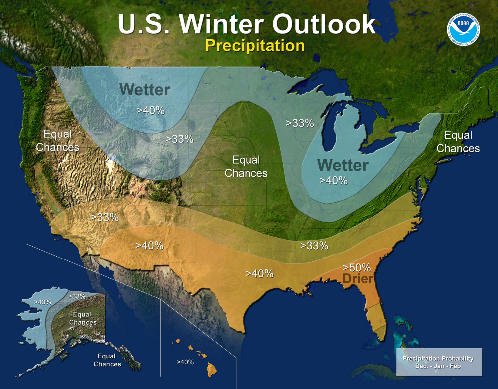
The 2017 U.S. Winter Outlook (December through February):
Precipitation
- Wetter-than-average conditions are favored across most of the northern United States, extending from the northern Rockies to the eastern Great Lakes, the Ohio Valley, in Hawaii and in western and northern Alaska.
- Drier-than-normal conditions are most likely across the entire southern U.S.

Temperature
- Warmer-than-normal conditions are most likely across the southern two-thirds of the continental U.S., along the East Coast, across Hawaii and in western and northern Alaska.
- Below-average temperatures are favored along the Northern Tier of the country from Minnesota to the Pacific Northwest and in southeastern Alaska.
- The rest of the country falls into the “equal chance” category, which means they have an equal chance for above-, near-, or below-normal temperatures and/or precipitation because there is not a strong enough climate signal in these areas to shift the odds.

- Despite the outlook favoring above-average precipitation this winter, drought is likely to persist in parts of the northern Plains, although improvement is anticipated farther West.
- Elsewhere, drought could develop across scattered areas of the South, mainly in regions that missed the rainfall associated with the active 2017 hurricane season.
NOAA’s seasonal outlooks give the likelihood that temperature and precipitation will be above-, near, or below-average, and also how drought is expected to change, but do not project seasonal snowfall accumulations. While the last two winters featured above-average temperatures over much of the nation, significant snowstorms still impacted different parts of the country. Snow forecasts are generally not predictable more than a week in advance because they depend upon the strength and track of winter storms. The U.S. Winter Outlook will be updated on November 16.
A video of NOAA’s 2017 Winter Outlook is available here.
Listen, the NOAA forecast/projection is extremely useful. Now we know for sure what will NOT happen.
+1
The organisation needs a proper clearing out, but it is not just NOAA.
mathematics has replaced physics in many fields.
Climate science is essentually VERY ROUGH numbers being used to pretend they have a precise theory, but you cannot have a precise theory made of extremely rough numbers.
Logic fail, politics, pseudo science
There is a reason why it is so hard to to find what the weather turned out to be in the past days and weeks.
All weather forecasters tells many times a day what the weather shoud be, but few follow up with actual facts of the past weather. That is because it would show that they could just have been reading coin flipping and thea blades, combined with the fact that winter is colder than summer.
We are told that warmer weather should give more storms, but the opposite is a fact in Danmark.
http://www.dmi.dk/nyheder/arkiv/nyheder-2017/oktober/vindstoed-af-stormstyrke-saa-ofte-rammer-de-danmark/
Danmark is a small country, so any small deviations of the weather systems could have great influence, but the meteorologists must know that.
Anyway DMI keeps a record (archive) of what the weather was, that is immidiately accessible, big credit for this service. Look at dmi.dk
‘…..NOAA’S Climate Prediction Center…..’
It just makes me laugh….
Since warming alarmists have taken over weather predictions for the long term, the Farmer’s Almanac is a better prognosticator of seasonal weather.