Wow! ECMWF Long-Term Weather Model Is Predicting a Super El Niño and I Mean Super
Guest Post by Bob Tisdale
I was notified today of the rather remarkable plume of ENSO forecasts for 2015 from ECMWF (European Centre for Medium-Range Weather Forecasts). See their System 4 ENSO region sea surface temperature anomaly forecast webpage here.
Figure 1 presents the ECWMF plume of sea surface temperature anomaly forecasts for the NINO3 region (5S-5N, 150W-90W), with some of the runs reaching highs in November 2015 in the neighborhood of +4.5 deg C.

Figure 1
For those unfamiliar with them, see the map of NINO regions here.
Figure 2 show the plume for the NINO3.4 region (5S-5N, 170W-120W). Note how a couple of the runs reach beyond the upper +4 deg C extent of the y-axis.
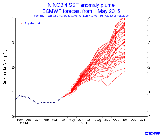
Figure 2
Now consider that NINO3.4 sea surface temperature anomalies peaked at +2.7 deg C in December 1997 in response to the 1997/98 super El Niño, and peaked at +2.8 deg C in January 1983 during the 1982/83 El Niño. See Figure 3, which is from the April 2015 Sea Surface Temperature (SST) Anomaly Update.

Figure 3
ARE NOVEMBER SEA SURFACE TEMPERATURE ANOMALIES OF +4.0 DEG C AND HIGHER IN THE NINO3.4 REGION PHYSICALLY POSSIBLE?
In the post Why Do El Niño and La Niña Events Peak in Boreal Winter?, we illustrated and discussed how and why the sea surface temperatures (absolute) of the NINO3.4 region mimic the seasonal cycle of, and come near to the values of, those in the western equatorial Pacific (5S-5N, 120E-165E) during a strong El Niño, like the one in 1997/98.
Based on the Reynolds OI.v2 data, the average November sea surface temperatures for the NINO3.4 region for the period of 1981-2010 is 26.64 deg C. That value serves as the November reference temperature for NINO3.4 sea surface temperatures anomalies.
Sea surface temperatures in the western equatorial Pacific (5S-5N, 120E-165E) are naturally warmer than those of the NINO3.4 region. The November sea surface temperature for the western equatorial Pacific in 2012 was 29.95 deg C; in 2013 the temperature there was 29.98 deg C; and, for 2014, it was 29.90 deg C. The average November temperature for the western equatorial Pacific for the past 3 years was about 29.94 deg C.
Let’s assume for a moment that the sea surface temperatures in NINO3.4 region did something very unusual in November 2015 and rose to that 2012-2014 average value of the western equatorial Pacific of 29.94 deg C. The November 2015 NINO3.4 sea surface temperature anomaly would be 3.3 deg C. That’s far short of 4 deg C.
Because someone’s bound to ask, in November 1997, the sea surface temperature for the western equatorial Pacific was 29.35 deg C, while the NINO3.4 region was remarkably similar at 29.31 deg C. And for November 1982, the sea surface temperature for the western equatorial Pacific was 29.08 deg C, while the NINO3.4 region was a little less at 28.81 deg C.
[My thanks for the heads-up, anonymous person.]
SOURCE
The Reynolds OI.v2 sea surface temperature data are available from the KNMI Climate Explorer.
IAN WILSON -made the prediction for this El Nino before anyone. Truth is the truth.
FINAL COMMENTS:
This study is still a work in progress but already we can make some interesting predictions, which if fulfilled would reinforce the claim that El Nino events are triggered by the Moon.
The first prediction is that because we are currently in a 31 year Full Moon Epoch for El Nino events. Hence, there should be heightened probability of experiencing a strong El Nino in the following years:
•2015-2016 (see figure 1)
2019-2020 and
2024
as these are the years where the lunar line-of-apse aligns with the Sun at the times of the Equinoxes.
The second prediction is that, starting sometime around the year 2021, we should begin to see El Ninos events that are more typical of the sequencing seen for the New Moon Epochs (i.e. they will be triggered
when the line-of-apse aligns with the Sun at the times of the Solstices). These times could include:
2022-23 (?) and
2027
Of there is always the caveat that we currently moving into an extended period of low solar activity which could reduce the the overall intensity of El Nino events out to at least the mid 2030′s.
Personally, I think he is wrong, and so is NOAA. My forecast for what is happening stems from the end of February of last year. The next 60 days will either show me that it is time to give up on the thoughts I have held over the last 15 months, or that there is reason to continue on to the next step.
Because Ian’s prediction has been correct he deserves some attention to how he came up with his prediction.
It has not been +0.5 or greater for five months so it’s not an El Nino episode yet. I think it pick up strongly from later this year, and continue through 2016 into 2017. I am basing that on what I think the NAO/AO will be doing.
I see three changes over the past six months as far as sea surface temperatures go.
1. Formation of El Nino.
2. Blob of water off W. North America not as intense.
3. North Atlantic cooling off.
Summer is exactly antiphase to the normal winter timing of the annually phase-locked el Nino. This will weigh against the development of an el Nino event. My guess therefore is that there will not be an el Nino or only a weak and ill-defined one. I also confidently predict that whatever happens in the Pacific will make no difference whatever to climate sociobiology.
Thanks Salvatore – time will tell whether Goldminor and NOAA are correct or whether my prediction is correct.
You have posted some comments from my page i.e.
“Of there is always the caveat that we currently moving into an extended period of low solar activity which could reduce the overall intensity of El Nino events out to at least the mid 2030′s.”
This has been updated by changing the word reduce to ….increase the overall intensity of El Nino events..
Ulric Lyons has suggested that El Nino may be a negative feedback mechanism for world mean temperature that tries to maintain the status quo – i.e. as it cools of the next 20 years or so due to low solar activity the El Ninos become more intense. I would be interested to see why he makes such claims.
If the level of solar activity were not weakening we would normally be going it a period where the overall impact of El Nino on world temperature would be reduced compared to the impact of La Nina – leading to a period of cooling. I believe that this change in relative strength between El Ninos and La Ninas is a 31 cooling cycle set by the strength Lunar tides (2005 – 2035 A.D.).
I am not sure what is going to happen when we have Lunar tides tending to weaken the strength of the El Ninos (relative to La Ninas) and the reduced solar activity tending to increase the strength of the El Ninos (assuming that Ulric is right).
I think the sea surface temperatures will decline in response to prolonged minimum solar conditions over the long run. This situation might result in more El Nino episodes but superimposed on lower sea surface temperatures overall.
The sun could promote more El Nino formation, while at the same time causing overall sea surface temperatures to decline.
Then as you say lunar tides will play a role.
Winter will come to South Australia and Tasmania. Below 0 C at the height of the clouds.
http://earth.nullschool.net/#2015/05/21/0600Z/wind/isobaric/850hPa/overlay=temp/equirectangular=-230.93,-27.79,1009
On 12 May this year, Australia’s Bureau of Meteorolgy officially declared the “start of a major El Niño event.” On that day the monthly SOI average was -10.11. As I understand it, an El Niño starts with an SOI of -8.0. BoM’s certainty is based on their idea of quality modelling. I am following the daily SOI data with interest. At what point can BoM’s prediction be verified or trashed (not for the first time for that alarmist institution!).
https://www.longpaddock.qld.gov.au/seasonalclimateoutlook/southernoscillationindex/30daysoivalues/
Does not look like a drought in eastern Australia, rather a lot of snow in the mountains.
http://earth.nullschool.net/#2015/05/20/0600Z/wind/isobaric/850hPa/overlay=total_cloud_water/equirectangular=-230.93,-27.79,1331
The current Kelvin wave has just peaked and is waning.
Will there be any following Kelvin waves?
Cold water at depth in the east equatorial Pacific seems to be interrupting the formation of further such waves.
If this is so then the current K wave could fizzle out and with it hopes of el Nino – again.
If this is a big event like they predict, will there be an equal La Nina to follow? And if so, how much could the temps drop?
One can only hope. At this point I’ll take any “normal” (e.g. rainy) El Nino at any strength.
Waiting for el Ninot, PART 13
ESTRAGON
Well here we are again, Vladimir old boy
VLADIMIR
Again – its not as if we’ve realy been anywhere else is it?
ESTRAGON
El Ninot is coming for sure this time – we’re not the only ones who think so.
VLADIMIR
Yes we’ve got quite a following at last. You’re really sure this time he will come?
ESTRAGON
I’ll bet my bottom dollar
VLADIMIR
You did that already
ESTRAGON
Just got to wait for those trades to finally reverse – they’re swerving a little north already – and for that Peruvian upwelling to finally stop – these will happen any day now…
VLADIMIR
Any day?
ESTRAGON
Yes – any day now…
The only people that would pick out a single model for discussion would be a cherry picker… Even when all the El Nino models converge, the experts tell us that long range they are not still not very useful.. The experts know how to use the models together and when they are more accurate.
see: “very few models ever suggested a major El Niño event (2). We obtain the range, or spread, using many runs from one model (an ensemble) and/or many runs from many different models (multi-model ensemble). Informally, a “strong El Niño” occurs when the ONI is ≥ 1.5°C (the ONI value for the 1997-98 El Niño was 2.4°C at its peak) and many of the purple lines do not exceed this threshold. In contrast, most of the year, the average forecast of the models predicted a “weak El Niño” (ONI at least 0.5°C but less than 1°C). ” http://www.climate.gov/news-features/blogs/enso/were-model-predictions-el-ni%C3%B1o-big-bust