The Southern Oscillation Index has been mentioned often in comments at WattsUpWithThat, in this series of blog posts about the upcoming El Niño. Curiously, Australia’s BOM Southern Oscillation Index for April 2014 is at a positive value that’s near to La Niña conditions, while the sea surfaces of the equatorial Pacific are now warming toward El Niño conditions. What gives?
We recently discussed the Southern Oscillation Index in the post El Niño and La Niña Basics: Introduction to the Pacific Trade Winds. In this post, I’ll only offer a brief introduction to the Southern Oscillation Index, so if you’d like a little more information, please refer to that post. Then, after the presentation of the BOM Southern Oscillation Index dataset, we’ll discuss the Equatorial Southern Oscillation Index data available from NOAA.
SOUTHERN OSCILLATION INDEX
The Southern Oscillation Index (SOI) is one of many indices that are used to document the timing, frequency and duration of El Niño and La Niña events. The Southern Oscillation Index represents the differences in the sea level pressures between Tahiti and Darwin, Australia…with the Darwin sea level pressures subtracted from those in Tahiti. See Figure 1 for the locations of both. The source of the illustration is the climate.gov webpage Climate Variability: Southern Oscillation Index. The INDO and EPAC regions are used for a similar index called the Equatorial Southern Oscillation Index, which we’ll discuss later.

Figure 1
The Southern Oscillation was first observed by Sir Gilbert Walker back in the 1920s but, if memory serves, it wasn’t associated with El Niño and La Niña events until the 1960s.
The positive value for the Southern Oscillation Index in April indicates the sea level pressure in Tahiti was higher than the sea level pressure in Darwin, which in turn indicates that the trade winds (those located off the equator in the Southern Hemisphere) were stronger than normal in April, blowing from east (Tahiti) to west (Darwin). Stronger-than-normal trade winds are typically associated with La Niña events, not El Niño events. A negative value would indicate the opposite…that the sea level pressure in Tahiti is lower than the sea level pressure in Darwin, which in turn indicates that westerlies are blowing from west to east. And a negative value is what we’d expect during an El Niño.
Then again, the El Niño hasn’t developed yet.
Figure 2 compares the Southern Oscillation Index values so far this year to the values during the development of the 1982/83 and 1997/98 El Niño. Again, we’re using those two strong El Niños as reference because some indicators are suggesting the developing El Niño may be strong. The Southern Oscillation Index had been decreasing as we would expect during the development of an El Niño, but then it made a quick change in April. Is that a concern if you’re looking forward to an El Niño this year? Nope.

Figure 2
Figure 3 is a spaghetti graph. It compares the evolution of the Southern Oscillation Index so far this year in red to the evolutions of the 1986/87/88 El Niño, 1991/92 El Niño, 1994/95 El Niño, 2002/03 El Niño, 2004/05 El Niño, 2006/07 El Niño and the 2009/10 El Niño. As shown, the Southern Oscillation Index has been positive even later in the year during the development of an El Niño. (See the Oceanic NINO Index for the “official” El Niño events.)

Figure 3
One of the difficulties with the Southern Oscillation Index is that it is based on sea level pressures for locations that are off of the equator, while El Niño events take place along the equator in the Pacific. The second complication is that the sea level pressures are measured at two specific locations and that means they are very susceptible to changes in local weather. This was discussed back in 1997 in a paper by Kevin Trenberth The Definition of El Niño. There Trenberth wrote:
Various versions of the SOI exist although, in recent years, most deal only with atmospheric pressures and usually only those at Darwin and Tahiti. In using the SOI based on just two stations, it must be recognized that there are many small scale and high frequency phenomena in the atmosphere, such as the Madden-Julian Oscillation, that can influence the pressures at stations involved in forming the SOI, but which do not reflect the Southern Oscillation itself. Accordingly, the SOI should only be used when monthly means are appropriately smoothed (Trenberth 1984, Trenberth and Hoar 1996a).
[Trenberth (1984) is Signal Versus Noise in the Southern Oscillation. And Trenberth and Hoar (1996a) is The 1990-1995 El Niño-Southern Oscillation Event: Longest on record, which was an early attempt to tie El Niño events to manmade global warming. That period has now been broken down into 2 “official” El Niño events, according to the Oceanic NINO Index.]
In Trenberth (1984), he presented the results after smoothing the Southern Oscillation Index data with an “11-term low-pass filter.” That wouldn’t help us in this short-term look, so let’s use a simple 3-month running mean. (NOAA uses the 3-month running mean for a version of its Equatorial SOI data, to be discussed later.) Figures 4 and 5 present the same comparisons as the earlier two graphs, but in them the Southern Oscillation Index values have been smoothed with 3-month running-mean filters. As shown in Figure 4, with that minor filtering, the current evolution does not look out of place compared to the 1982/83 El Niño or the 1997/98 El Niño. And the current evolution appears within the range of the other El Niño events since 1986. See Figure 5.
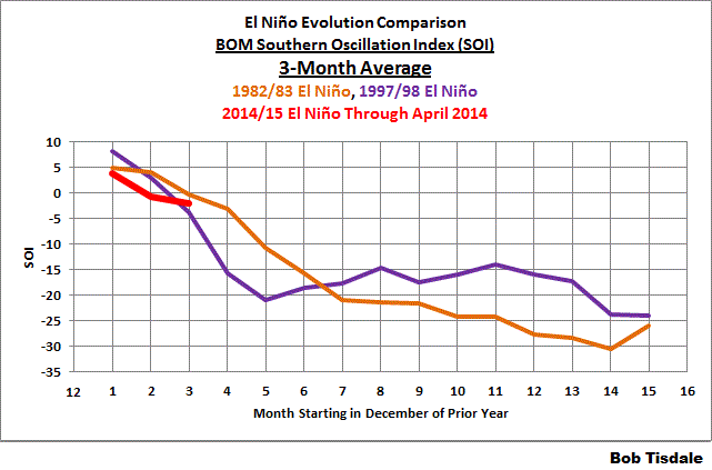
Figure 4
# # # # # #

Figure 5
But that still doesn’t help us with the fact that the reference points for the Southern Oscillation Index are off the equator while El Niño events are focused along the equator in the Pacific. Thus…
NOAA’S EQUATORIAL SOUTHERN OSCILLATION INDEX
In their Climate Prediction Center Equatorial Southern Oscillation Index (1949-present) webpage, NOAA describes the dataset as:
Abstract:
This is one of the CPC’s Monthly Atmospheric and SST Indices. It contains Equatorial Southern Oscillation Index (standardized sea level pressure differences between EPAC (5N-5S, 80W-130W) and INDO (5N-5S, 90E-140E)) for the period of 1949-present. The anomalies are departures from the 1981-2010 base period means.
Purpose:
This index is constructed for applications in climate monitoring, climate analysis and verifications of numerical models.
Please refer to Figure 1 again for the locations of the EPAC and INDO regions. Because they are comparatively large regions, they should be less susceptible to weather noise, and because they are located along the equator, they should better capture the equatorial trade winds. The Equatorial Southern Oscillation Index is calculated in a similar fashion. It represents the sea level pressure difference between the eastern equatorial Pacific (EPAC) and the sea level pressure of equatorial Indonesia (INDO)…with INDO subtracted from EPAC.
The Equatorial Southern Oscillation Index data are available from the NOAA Monthly Atmospheric & SST Indices webpage. The Indonesia (INDO) sea level pressure data (standardized) are here, the Eastern Equatorial Pacific (EPAC) sea level pressure data (standardized) are here, and the Equatorial Southern Oscillation Index data are here (and it appears the difference is then standardized as well.) NOAA also provides the Equatorial Southern Oscillation Index data as a 3-month running mean here. But there really doesn’t appear to be the same need to smooth the Equatorial Southern Oscillation Index data, as you shall see.
Figure 6 compares the Equatorial Southern Oscillation Index values so far this year to the values during the development of the 1982/83 and 1997/98 El Niño. The evolution this year falls in line with the two strong El Niños.

Figure 6
Compared to the other El Niño evolutions, Figure 7, this year appears to be the stronger (more negative) than normal at this stage.

Figure 7
And for those who would like to see the comparisons with the Equatorial Southern Oscillation Index data smoothed with the 3-month running means see Figures 8 and 9.

Figure 8
# # # # # #

Figure 9
COMPARISON OF THE TWO SOUTHERN OSCILLATION INDICES
Figure 10 compares the BOM Southern Oscillation Index data to the NOAA Equatorial Southern Oscillation Index data. The BOM also multiplies their SOI data by 10 after standardizing it, so for the comparison I scaled it back by dividing their data by that factor. The correlation between the two indices is not as good as one might suspect, with a correlation coefficient of 0.77.

Figure 10
And NOAA’s Equatorial Southern Oscillation Index data correlates better (-0.83) with NINO3.4 sea surface temperature anomalies (Kaplan SST) than does the BOM Equatorial Southern Oscillation Index data (-0.71).
CLOSING
The Southern Oscillation Index from BOM has been around for a long time. It is a commonly used ENSO index. It is noisy and, at times, does not appear to reflect what’s taking place along the equatorial Pacific. Then again, it is much studied with respect to its impact on weather in Australia and New Zealand.
It appears that NOAA’s Equatorial Southern Oscillation Index better reflects what’s taking place along the equator in the Pacific, where ENSO events take place, but it is not as popular as the BOM SOI.
EARLIER POSTS IN THIS SERIES
- The 2014/15 El Niño – Part 1 – The Initial Processes of the El Niño.
- The 2014/15 El Niño – Part 2 – The Alarmist Misinformation (BS) Begins
- The 2014/15 El Niño – Part 3 – Early Evolution – Comparison with 1982/83 & 1997/98 El Niño Events
- The 2014/15 El Niño – Part 4 – Early Evolution – Comparison with Other Satellite-Era El Niños
- The 2014/15 El Niño – Part 5 – The Relationship Between the PDO and ENSO
- The 2014/15 El Niño – Part 6 – What’s All The Hubbub About?…
- The 2014/15 El Niño – Part 7 – May 2014 Update and What Should Happen Next
And for additional introductory discussions of El Niño processes see:
- An Illustrated Introduction to the Basic Processes that Drive El Niño and La Niña Events
- El Niño and La Niña Basics: Introduction to the Pacific Trade Winds
- La Niñas Do NOT Suck Heat from the Atmosphere
- ENSO Basics: Westerly Wind Bursts Initiate an El Niño
FURTHER READING
My ebook Who Turned on the Heat? goes into a tremendous amount of detail to explain El Niño and La Niña processes and the long-term aftereffects of strong El Niño events. Who Turned on the Heat? weighs in at a whopping 550+ pages, about 110,000+ words. It contains somewhere in the neighborhood of 380 color illustrations. In pdf form, it’s about 23MB. It includes links to more than a dozen animations, which allow the reader to view ENSO processes and the interactions between variables.
I’ve lowered the price of Who Turned on the Heat? from U.S.$8.00 to U.S.$5.00. A free preview in pdf format is here. The preview includes the Table of Contents, the Introduction, the first half of section 1 (which was provided complete in the post here), a discussion of the cover, and the Closing. Take a run through the Table of Contents. It is a very-detailed and well-illustrated book—using data from the real world, not models of a virtual world. Who Turned on the Heat? is only available in pdf format…and will only be available in that format. Click here to purchase a copy. Thanks. Book sales and tips will hopefully allow me to return to blogging full-time once again.
Jack (Puim @NotreDameFan27)
“Eric, I never predicted that there wouldn’t be an el nino”
Umm…
It clearly appears you didn’t know what was going on a few months ago, even if there was going to be an El Nino to begin w/, you have consistently tried to incorrectly downplay the evolution of this El Nino simply because you don’t want to see the following global temperature rise that will come with it.
March 9th
“Do you think there will be an el nino?”
March 7th
“Also, the west warm pool is actually cooling and contracting. Cooling from east growing larger westward by the week.”
March 6th
“Also the western warm pool is currently breaking up and cooling. There’s going to be a lot of disappointed people.”
” The pacific is currently 1 to 3 degrees C COOLER all the way to 170 deg lat. All conditions point to la nina.”
It’s really sad to see that you’re already trying to claim I’m wrong when we haven’t even observed the peak of the ENSO event yet, much less the official initiation of the El Nino & you wonder why Bob Tisdale continues to compare the current event to the 1997-98 & 1982-83 El Ninos, he wouldn’t be doing that if we weren’t “challenging” these El Ninos. Not to mention you came onto this blog mud-slinging w/ multiple personal attacks (as I see is common on your twitter account as well). Should make you wonder who really is the immature one here…
@ur momisugly WeatherDave
I had no intention to confuse anyone, there are oceanic AND atmospheric Rossby waves, the oceanic rossby waves are most evident when the eastward moving equatorial kelvin wave strikes the coast of South America & its energy is dispersed back westward in the form of Rossby Waves.
Also, you might want to check this site, has a lot of charts, graphs, data, etc. pertaining to the MJO
http://cawcr.gov.au/staff/mwheeler/maproom/RMM/
Mean seasonal cycle MJO RMM1+RMM2 31 day running mean (shows the peak in amplitude in around March, not DJF)
http://cawcr.gov.au/staff/mwheeler/maproom/RMM/ts.PCvar.seasonalcycle.gif
@Weatherdave
I wouldn’t even go as far to say that the MRG promotes La nina & that it moves west, it only does so, when its wavelength & period begins to approach that of a Kelvin Wave. The MRG wave type is relatively similar to the Equatorial Convectively Coupled Kelvin Wave, although its zonal wavenumber is higher, more towards 4-5, & thus its frequency is as well. Usually, the Mixed Rossby-Gravity wave with its shorter period/wavelength disperses energy eastward, however, there are occasions where the wave crests & troughs can oddly travel west in the presence of longer periods that start to grow closer to the Eq Kelvin Wave, or “Supercluster”. The largest significance of the MRG wave in terms of tropical cyclone genesis pertains to the western Pacific, when these disturbances manifest themselves into off-equatorial gyres that happen to move off the equator where they typically reside. With time, as zonal confluence/convergence increases, this leads to a contraction of the MRG & a piling of up air that subsequently induces rising air in the vicinity of the evolving Mixed-Rossby Gravity & thus could then potentially lead to the genesis of tropical cyclones in the western pacific. These TCs can thereby, if accompanied by another tropical cyclone relatively symmetric about the equator, create Equatorial Rossby Waves, typically found on the backside of an upward MJO pulse, which actually enhance El nino (not la nina) via WWBs that are focused near the Equator. In addition, Mixed-Rossby Gravity waves can propagate through the downward phase of the MJO as “dry modes”
Pamela Gray says: “Bob, that NE extratropical North Pacific warm pool combined with a slight to strong El Nino that is still in place when Winter is upon us again leads to moisture being picked up and brought to shore which then falls as tons and tons of snow in the mountains. Could this be similar to what happened in the mid-1990′s….”
Pamela, your question is local-weather-related and well beyond my scope. Sorry.
The things I wrote in early March were true for early March. We were in a nearly la nina state. Then we had that spike and kelvin wave. So now we have the onset of the el nino. But since you only cherry picked three quotes, you ignore the part where I said I agreed that an el nino was due, but that given the cold PDO I didn’t think it would be a strong one.
You still don’t want to admit you’re wrong though about the things you wrote Feb/March. Problem is you’re young. So this is what? Your first el nino? You were 17(?) 18(?) during the 2009-10 el nino?
I get that you know a lot about the weather. I’ve always thought that about you. The problem is your immaturity. Like all young people, myself included when I was young like you, you think this will be worse than ever before or different than before or extraordinary in some way because you have no other experiences to draw upon. When you’re young you think everything is new and special. There were doomsday predictions about a variety of things when I was growing up too. None of them came true. Thus, with time and age, one grows more skeptical of claims of something being “worst one ever” especially by some young guy who is experiencing his first el nino ever. Cynicism is just my natural trait now. Instead of believing in extraordinary events, you begin asking yourself why would this event be any different than other events? You say it’s because of the kelvin wave. But I said that there were other factors involved. You decided that you just know better. Here’s a fact for you, sonny, people like you have been predicting super el ninos since the last one in 1997. That’s right. Every single el nino was supposed to be a super el nino. Literally, not one of them were ever predicted to just be a normal, average el nino. There were predictions of super el ninos when there weren’t even any el ninos at all. I have learned that when people want to see a super el nino brewing, they will pretty much grasp at anything to convince themselves of it.
So, yes, i’m skeptical. Trusting a 22 year old kid, following his first el nino live, because there is a strong kelvin wave — even though there are records on kelvin waves going back only to the early 90s, is not very convincing. We don’t know what kelvin waves were like in the 80s, 70s, 60s, etc. There is not enough data on kelvin waves to make absolute predictions solely on them. Yet. that kelvin wave is all you have to go on. The only point I have ever made, and still make, is that there are many factors that go into an el nino. You just ignore all of those which don’t support your hypothesis. The fact is you also predicted that we would be in an el nino by end of March or early April, but you’re too cowardly to admit that now too.
P.S. Bob also seems to agree that a lot more has to happen to give current el nino more power before we come close to a 1997 level event.
Above message for Eric Webb.
Also, Eric Webb, keep in mind all nino models, save two, agree with my assessment of what will happen. 1.3 to 1.6 J-J-A.
To Eric Webb
Looks like you’ve gone and done some homework or you know this stuff anyway. This is way off Bobs Post so I’m going to make this real brief, but it’s great to have a good conversation along these lines. Us tropical forecasters usually don’t even look at MRG’s, ER1s etc, but certainly do so for MJO. However I am firm in my belief as are my colleagues that here in the SW Pacific (I am in NZ) the MJO is most active in the austral summer months. I’m getting to think you know about RMM1 and 2 but for those that follow this and care, they refer to cloud amount and upper/lower wind in association with the MJO phase. These are used with a chart that has a center circle with the chart divided into phases, with phase 1 the Indian Ocean. As the MJO travels east the numbers increase; our area is 5,6 and 7. A jagged line starts in the centre of the circle and as the MJO moves east the line does too. If it stays in the circle the MJO is very weak (RMM #:s small) and when MJO is strong the line moves outside of the circle. The farther away from the center the stronger the pulse. This chart is used with satellite imagery for convective intensity and that’s how we keep track of the MJO.
Thanks for the links but I use the main site almost every day. Oh, and look at the MRG forecast charts; you’ll see they travel west.
@ur momisugly Jack
I didn’t cherry-pick anything, I can dig up more quotes if you want, its very clear that you had no clue what was going on in that point in time, & didn’t think twice @ur momisugly all about the oncoming El Nino, classic case of the “pot calling the kettle black”. Despite my age, I am well aware of the various literature & hype from the usual suspects surrounding the constant call for Super el ninos, but what you don’t seem to grasp is that I am not forecasting that all, in fact, all of the graphics I posted are simply up for interpretation by the viewer (you). Yes, due to MJO forcing, the first Kelvin Wave was on par w/ 1997-98, but you seem to run w/ this & in an immature fashion, decide to point fingers @ur momisugly me/incorrectly interpret that as if I’m somehow forecasting another El Nino like 1997-98, it seems that you obviously missed the part where I said my forecast if for 2.0-2.3C ONI maximum “challenging” the great El Ninos of 1997-98 & 1982-83, but, not a super El Nino in of itself. Even I understand that in this day & age it’s somewhat of a misnomer to claim that we have a lack of data, this is prevalent in nearly every sect of meteorology. At no point did I make the claim we’d be in el Nino by the end of March, beginning of April, there’s a gigantic difference between that & the AMJ tri-monthly period that I did claim. Ok, yes this is my first El Nino event, in fact I was (not 18 or 19) but only 13 when the 2009-10 el nino was underway. I’ll be quite frank with you, it’s not smart to dismiss my ideas or underestimate me simply by virtue of age, physical hinderances often speak little in accordance to intelligence. Also, it’s not wise to claim the models are in your favor (you don’t see me referring much to models), especially in this time of the year, as we are in the midst of the “spring barrier”, usually when ENSO forecasts in the models bust, in particular, they tend to underestimate the severity of strong ENSO events.
@ur momisugly WeatherDave
The key words are “energy is dispersed” eastward by MRG, I did say that when their wavelengths, time periods broaden out, you can get the illusion that they travel westward, but they certainly do not promote La Nina, especially when they trigger TC genesis in the western Pacific that can lead to westerly wind stress & Eq Rossby Waves. To put it simply, I’m very familiar with the MJO & its various components & I’m well read on the subject & consider myself a huge fan of Dr. Ventrice. I am currently undertaking work in analyzing the MJO & how each phase in terms of NSD, HD, MHD, US tropical cyclone landfalls, tropical cyclone tracks, & even daily ACE for the Atlantic basin. I plan on expanding this to include other basins such as the Eastern & Northwestern Pacific. So far, I’m actually discovering that there is a “double-peak” in tropical cyclone activity in the Atlantic in association w/ the MJO, not just the simple active phase 1-2 & suppressed phase 7-8 as noted by a multitude of scientific literature. I fact, I’m seeing that in La Nina years especially, there’s actually a tendency for increased tropical cyclone activity in the Atlantic basin when the MJO pushes into the typically unfavorable Maritime Continent (phase 4-5). I will have more on this later in the summer when I complete this work.
You make me smile Eric Webb. Keep up that enthusiasm and hard work.
Eric Webb
use also observation of the flow of air in the stratosphere. According to me occurs now cooling Pacific Ocean along South America.
http://www.cpc.ncep.noaa.gov/products/intraseasonal/temp50anim.gif
So it looks at the level of 500 hPa.
http://earth.nullschool.net/#current/wind/isobaric/500hPa/orthographic=-109.88,0.35,365
@ur momisugly Ren
Stratospheric temperatures have little-no relevance to what’s actually occurring @ur momisugly the surface, as we are in fact nearing El Nino w/ the overall trend in all ENSO regions featuring warming…
The sea surface temperature anomalies of all four of the most-often-used NINO regions are now above the threshold of an El Nino.
http://bobtisdale.wordpress.com/2014/05/12/sea-surface-temperature-anomalies-of-all-four-nino-regions-are-now-above-the-threshold-of-an-el-nino/
While we are concentrating on a “Major” El Nino, I found the even numbered figures to be very enlightening. Understanding that the SOI is not equatorial, the equator does not exist in a vacuum. So the pattern seems to be more like the smaller El Ninos. Of course given the relative small sample size, anything is possible. But it is good to see the comparisons with the other El Ninos.
Eric Webb says:
@ur momisugly Ren
Stratospheric temperatures have little-no relevance to what’s actually occurring.
I’m not so sure.
http://earth.nullschool.net/#2014/05/16/0900Z/wind/isobaric/250hPa/equirectangular=-122.55,0,160
Waiting for el Ninot, episode 3
ESTRAGON
The big switch will happen any day now, my friend…
VLADIMIR
What big switch?
ESTRAGON
All the water in the west and east Pacific changes place – the east Pacific gets full of warm water from the west.
VLADIMIR
But how can half the water in the world just up and change places, just like that. You’re full of it.
ESTRAGON
Actually I wondered the same. I phoned a friend who explained that its really just an accelerated subsurface equatorial counter current. But the east Pacific is warming up.
VLADIMIR
So we’re all set for the long-promised coming of el Ninot … O my heart, how much more can I take!?
ESTRAGON
We’re just waiting for those trade winds to drop…
VLADIMIR
And for that Kelvin wave to gain some strength again…
ESTRAGON
And for the Peruvian upwelling to stop…
VLADIMIR
And for the SOI to pop down again…
ESTRAGON
(But there are several flavors of SOI so you can choose the one which looks best)
VLADIMIR
But all these things will happen any day now, wont they?
ESTRAGON
Yes… any day now
VLADIMIR
Did you manange to get that shoe off by the way?
Hi Bob, Being in NZ we naturally look at our cousins at BoM and their view of ENSO. For the 3.4 to indicate El Nino there must be a 5 month running average exceeding +0.4 for 6 consecutive months.