Seas have been rising and falling for thousands of years – without help from the EPA or IPCC
Guest essay by Robert W. Endlich
Sea levels are rising rapidly! Coastal communities are becoming more vulnerable to storms and storm surges! Small island nations are going to disappear beneath the waves!
Climate alarmists have been making these claims for years, trying to tie them to events like “Superstorm” Sandy, which was below Category 1 hurricane strength when it struck New York City in October 2012, and Typhoon Haiyan, which plowed into the low-lying central Philippines in November 2013.
For alarmists, it does not seem to matter that the strength and frequency of tropical storms have been decreasing in recent years, while the rate of sea level rise has fallen to about seven inches per century. Nor does it seem to matter that the lost lives and property have little to do with the storms’ sheer power. Their destructive impact was caused by their hitting heavily populated areas, where governments had not adequately informed citizens of the size and ferocity of imminent storm surges, too few people had evacuated – and people, buildings and emergency equipment were insufficiently prepared to withstand the furious storm onslaughts.
The alarmist cries are not meant to be honest or factual. They are intended to generate hysterical headlines, public anxiety about climate change, and demands for changes in energy policies and use.
China is rapidly becoming one of the richest nations on Earth. It is by far the largest single emitter of carbon dioxide, which alarmists claim is causing “unprecedented” storms and sea level rise. And yet at the recent UN-sponsored climate talks in Warsaw, China led a walkout of 132 Third World countries that claim First World nations owe them hundreds of billions of dollars in “reparations” for “losses and damages” allegedly resulting from CO2 emissions.
The Obama Administration brought (perhaps “bought” is more apt) them back to the negotiating table, by promising as-yet-unspecified US taxpayer money for those supposed losses. Details for this unprecedented giveaway will be hammered out at the 2015 UN-sponsored climate confab in Paris, safely after the 2014 US mid-term elections. Meanwhile, a little history will be instructive.
In 2008, presidential candidate Barack Obama proclaimed, “This was the moment when the rise of the oceans began to slow.” He was actually right. Sea level rise has slowed, but not because of CO2 emissions, which are still increasing. Mother Nature cannot be bought.
Sea level changes over relatively recent geologic and human history demonstrate that alarmist claims do not withstand scrutiny. Sea levels rose significantly after the last ice age, fell during the Little Ice Age, and have been rising again since the LIA ended around 1850. In fact, Roman Empire and Medieval port cities are now miles from the Mediterranean, because sea levels actually fell during the Little Ice Age.
During the deepest part of the last ice age, known as the Wisconsin, sea levels were about 400 feet lower than at present. As Earth emerged from the Wisconsin some 18,000 years ago and the massive ice sheets started to melt, sea levels began rising. Rapid sea level rise during the “meltwater pulse phase,” about 15,000 years ago, was roughly five meters (16 feet) per century – but then slowed significantly since the Holocene Climate Optimum, about 8,000 years ago.

Those rising oceans created new ports for Greek and Roman naval and trade vessels. But today many of those structures and ruins are inland, out in the open, making them popular tourist destinations. How did that happen? The Little Ice Age once again turned substantial ocean water into ice, lowering sea levels, and leaving former ports stranded. Not enough ice has melted since 1850 to make them harbors again.
The ancient city of Ephesus was an important port city and commercial hub from the Bronze Age to the Minoan Warm period, and continuing through the Roman Empire. An historic map shows its location right on the sea. But today, in modern-day Turkey, Ephesus is 5 km from the Mediterranean. Some historians erroneously claim “river silting” caused the change, but the real “culprit” was sea level change.
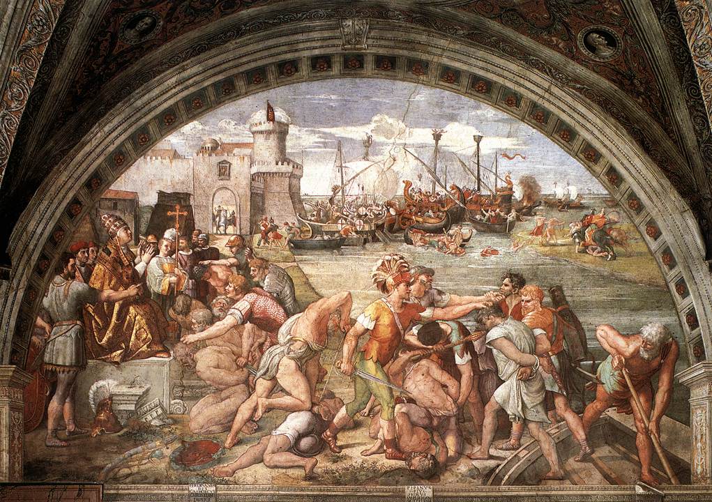
Ruins of the old Roman port Ostia Antica, are extremely well preserved – with intact frescoes, maps and plans. Maps from the time show the port located at the mouth of the Tiber River, where it emptied into the Tyrrhenian Sea. The Battle of Ostia in 849, depicted in a painting attributed to Raphael, shows sea level high enough for warships to assemble at the mouth of the Tiber. However, today this modern-day tourist destination is two miles up-river from the mouth of the Tiber. Sea level was significantly higher in the Roman Warm Period than today.
An important turning point in British history occurred in 1066, when William the Conqueror defeated King Harold II at the Battle of Hastings. Less well-known is that, when William landed, he occupied an old Roman fort now known as Pevensey Castle, which at the time was located on a small island in a harbor on England’s south coast. A draw bridge connected it to the mainland. Pevensey is infamous because unfortunate prisoners were thrown into this “Sea Gate,” so that their bodies would be washed away by the tide. Pevensey Castle is now a mile from the coast – further proof of a much higher sea level fewer than 1000 years ago.
Before modern Italy, the region was dominated by the famous City States of the Mediterranean, among which is Pisa, with its picturesque Cathedral Square and famous Leaning Tower. Located near the mouth of the Arno River, Pisa was a powerful city, because maritime trade brought goods from sailing ships right into the port. Its reign ended after 1300 AD, the onset of the Little Ice Age, when sea levels fell and ships could no longer sail to her port. Once again, some say “river silting” was the cause.
However, Pisa is now seven miles from the Tyrrhenian Sea, with large meanders upstream from Pisa and little meandering downstream. When a river is “at grade,” the downstream gradient is as low as possible, as with the meandering Mississippi River and delta in Louisiana. Rivers with a strong downstream gradient flow to the sea in a direct route, with few meanders, as with the Rio Grande in New Mexico.
The facts of history are clear. Sea level was 400 feet lower at the end of the Wisconsin Ice Age, 18,000 years ago. Sea levels rose rapidly until 8,000 years ago. As recently as 1066, when the Normans conquered England, sea levels were quite a bit higher than today.
During the Little Ice Age, 1300 to 1850 – when temperatures were the coldest during any time in the past 10,000 years – snow and ice accumulated in Greenland, Antarctica, Europe and glaciers worldwide. As a consequence, sea levels fell so much that important Roman Era and Medieval port cities (like Ephesus, Ostia Antica and Pisa) were left miles from the Mediterranean.
Since the Little Ice Age ended about 160 years ago, tide gages show that sea level has risen at a steady rate – with no correlation to the rise in atmospheric carbon dioxide levels.
Sea level is a dynamic property in our planet’s climate cycles, which are closely linked to changes in solar energy output and other natural factors. It is unlikely to change in response to tax policies that make energy more expensive and economies less robust – no matter what politicians in Washington, Brussels or the United Nations might say.
Much to their chagrin, Mother Nature doesn’t listen to them. She has a mind of her own.
____________
Robert W. Endlich served as a weather officer in the US Air Force for 21 years and a US Army meteorologist for 17 years. He was elected to Chi Epsilon Pi, the national Meteorology Honor Society, while a basic meteorology student at Texas A&M University. He has degrees in geology and meteorology from Rutgers University and the Pennsylvania State University, respectively, and has studied and visited the ancient sites of Rome, Ostia Antica and Pisa.
The article is excellent as a primer/reminder for layfolk about the real reasons for sea level changes and yet again as a perfect indicator for the current SL rate changes as relatively miniscule.
I know I’ve probably said it before, but All geologists know full well how much sea level as well as ‘ground level’ can and has changed. I’d guess most if not All hydrologists/hydrogeologists also know how little is known about the hydrological cycle and the variation in ‘storage’ within the various components of that system (sea, ground and air) locally and globally. (as an example, think of a multi year drought and the effect on the groundwater in an affected area, river base flow, etc, – where is the water that previously fell as rain? – you get the picture? – add in ice accumulation, glacial change, precipitation changes, water extraction, cloud formation, blah, blah, etc, and perhaps thermal expansion/contraction, and you fast realise that you can’t actually know a great deal about what is happening, let alone pinpoint causes!)
As for actual SL measurements – that is another minefield of corrections/assumptions and adjustments! If this article even gets a single layperson to sit down and think about what sea level actually is (and I’m ignoring things such as subduction zones (land loss), oceanic/tectonic spreading, volcanic islands forming, etc, etc) and how it cannot realistically be measured (where is your fixed reference point?) it becomes quite clear that the warmist/alarmist claims are largely pure bunkum, easily explained away with natural causes – sound familiar?
just my view, of course……..
I grew up in Benfleet, South Essex, England. Studying local history at school I learnt that Sooth-east England was sinking at about 8 inches (20cm) per hundred years. In Roman times, it was possible to cross to Canvey Island from Benfleet on stepping stones. Now Canvey Island is entirely below sea level, and is protected by a high wall all round it. At the same time, North-west Britain is rising, “springing back” as it were from the weight of glaciers which covered it during the last ice age. Point being, it’s dangerous to draw conclusions from apparent changes in sea level.
Sceptics may remember when the Sunderban islands (India/Bangladesh coast) briefly became the poster boy for sea level rise alarmists. Apparently two islands had disappeared from the Sunderbans. Rising seas! Climate change! shouted the knee-jerk climate boys. It didn’t take long to expose this idiocy. The story was in any case over 20 years old (dating from 1984), and the Sunderbans are particularly prone to change, through delta flooding, the effects of monsoons, and weight of vegetation.
Warren: http://canute2.sealevelrise.info/slr/Story%20of%20Canute
Warren: I thought you’d like that site as it agrees with you. It misses the mark in a very funny way (IMHO). CO2 does not control the temperature and temperature does control sea level. Hence CO2 will remain a minor greenhouse gas at best and is not responsible for any sea level rise.
I am a little confused in the comparison of your graph to your alleged recent sea level changes. The graph looks slightly increasing from 8k to 4k years ago, and flattens out from 4k to now. Your scale is in meters, but it seems the line is within a few cm of present levels. How does that move the shore line 5 km? Is it possible that you are picking areas where local subsidence is occurring?
REPLY: The graph is actually from Robert Rhode at Global Warming Art via Wikipedia. I added it for context to the point about the meltwater pulse that was made. – Anthony
New Zealand court told someone from Kiribati that he can’t claim refugee status due to sea level rise.
When you say “Mother Nature can’t be bought” you are literally correct. However it has been noticed before that those whom control the present control the past. If you want to make something unprecedented modify the past. If you’re not happy with the rate of sea rise/ temp rise just change the past. Then justify it by claiming past wasn’t calibrated correctly. Or pay someone to do a study that corrects past sea levels by proxy. “good science” is getting replaced by science of convenience or science to order.
I forgot to show the /sarc above. Sorry
HELP!! I HAVE A QUESTION !!!
Water is incompressible ( constant volume) and all the major oceans and seas are connected. So how is it possible that different shoreline / port locations around the world can experience totally different changes in sea level as, say , the glaciers melt?
Wouldn’t the rise in sea level due to melting glaciers register the same everywhere?
There have been a couple of attempts to answer this, but I’ll amplify it still further.
As was pointed out, the bulk modulus of water (basically, its “inverse compressibility”) is small, so it takes a huge change in pressure to make a large change in volume. Seawater at 1000 atmospheres (10 km down) is only 4-5% more dense than water near the surface.
However, the bulk modulus is a significant function of temperature. When I make beer, I have to be very careful to let the wort I’m boiling down cool before I measure its specific gravity (density) because it is considerably less dense at the boiling point than it is at room temperature (where my hydrometer is normalized). This temperature difference is between 373K and 300 K, so it is a relative temperature change of around 20%. The change in density is much smaller — a bit less than a half a percent — but that’s a LOT in context.
Water is also “odd” in that it achieves its highest density at around 4C (281K), not at its freezing point. Ice actually floats and is LESS dense than water by around 10%. That is, water expands by 20-30 times as much cooling from 4C to freezing than it does expanding from 4C to 100C. So BOTH ice and the coldest seawater and all the warmer water float on top of 4K seawater.
Since heating of seawater at the bottom of the ocean is nearly negligible — a fraction of a watt/m^2 — the ocean stratifies with 4K water on the bottom nearly everywhere below a layer called the thermocline. Warmer (and in places, colder) water literally floats on top of this most-dense 4K water.
What this means is that water can be deeper near the shore where it is warm (or for that matter, at the poles where it is almost freezing) than it is in mid-ocean where surface water is cooler even though it is nominally isostatic everywhere. Only this is only one of many problems with sea level. The Earth is not a sphere, so even if it were isostatic and at one temperature, water level measured relative to the surface (of the Earth) would vary. The Earth is not an inertial reference frame — it is rotating and revolving, and hence water will naturally bulge higher at the equator than at the poles. The Earth is revolving around the gravitationally bound SUN and is being revolved around by the gravitationally bound MOON and hence experiences tides that lift the entire ocean system in a propagating, irregular wave and at the same time causes the surface crust of the Earth to rise and fall by some 18 cm a day (so “ground level” isn’t even a local constant relative to e.g. “the center of mass of the Earth” as a sort-of fixed point). The ocean and Earth surface itself is being differentially pressed on by an atmosphere with highly (maybe 5%) variable pressure, which acts like a thumb on oceanic waters pressing them down in one place to lift them up somewhere else.
Finally, the Earth’s surface is not uniform. The ocean’s depth varies, there are mountains and continents and islands. Gravitation actually varies all over the surface of the Earth, which causes the buoyancy of water to covary with it, and near continents it pulls the ocean sideways to pile up water near the shore. As if this weren’t the worst of the insults, none of this is sitting still — the continental plates are constantly moving, ocean rifts are spreading, magma is oozing along beneath the surface and uplifting or pulling continents themselves (or the ocean bottom) up or down, and thereby altering both local gravity and the local properties of the tidal waveforms and the instantaneous directions of oceanic and atmospheric currents everywhere.
In a sense, the oceans are a pretty good “thermometer”. Warm water expands and floats higher than cold water on the uniformly cold water below. A major part of sea level rise (to the extent that it can be untangled from measurements given all of the above) is simply due to the gradual warming of the Earth post LIA. This rise is not uniform — it is concentrated where the sea surface temperature has increased the most. It does not correspond to glacial melt.
Melting sea ice doesn’t make a huge increase in sea level because it floats both before and after it melts, but as noted water just at freezing actually floats on 4K water so it does uplift the surface somewhat out to where the water temperature crosses the 4K isotherm. Melting glacial ice does add to ocean volume, and further does so with less dense fresh water. Over time this rise would be uniform enough, if the system were static enough over that time. However, as the list of things affecting sea level indicates, that isn’t likely to be true, ever. And note well that I haven’t even talked about ordinary waves or the effects of the prevailing winds (that can pile water up on one side of an ocean relative to the other) or the effects of variable salinity (which affects the density and hence the buoyancy of the water itself and hence the sea level). All of these effects taken together dictate the thermohaline circulation — the global-scale (very crude) pattern of ocean currents that moves water up, down, and sideways throughout all of the seven seas as its salinity and temperature vary, steered by the continents and sea-bottom and the tides and the winds and the local gravitation and coriolis forces.
Anthony posted a lovely video on the difficulty of determining sea level a few days ago. Well worth the watch.
rgb
If sea level change put Ephesus 5km inland, rather than river silting as I was told when visiting there, then how come this isn’t reflected in the graph? There should be a big dip in sea level from 2k years ago to the present.
You could interpret the article also differently – the sea-level changes in the past millennia (lets limit it to 2000 years) are linked to relatively small temperature changes. So if there is some warming caused by humans, sea-level will respond sooner or later again.
Troy was a port on the mouth of a river It is now 14 Km from the sea. The river has also moved some km away. According to the guide we had we visited Troy the reason for Troy being so far inland is the sediment brought down by the river. This leads to an important cause of sea level rise that is never mentioned. All silt deposited in rivers, streams, lakes and oceans whether carried by ice or water, displaces water which must cause the water level to rise somewhere, usually in the oceans. So silt displacement has to be a contributing factor.
I live in Hardys Bay, which part of Brisbane Waters, an estuary of the Hawkesbury River, north of Sydney. Since 1950 parts of our bay have gone from being deep water with jetties that 30′ vessels could moor at to mudflats and sandbanks. Hundreds if not thousands of tons of silt are deposited each year in the bay by the rivers that end in the Brisbane Water estuary. And, yes mankind is partly responsible because of the extensive housing development that has occurred in this vicinity. The silting up of the bay is also aided and abetted by the local council’s poor drainage systems.
Warren,
Another tragic slashing by Occam’s Razor. Sure there could be, but is there? Confronted with a clear record of natural variability, to posit an anthropogenic factor, you should offer some proof. Have any?
We didn’t think so….
Warren says:
December 2, 2013 at 5:09 am
I don’t understand why this article should carry any scientific weight whatsoever. It’s argument is that “sea levels have been rising and falling throughout history, so the proposition that mans activities is warming the planet and causing sea level rise is ridiculous”. Same goes for the oft seen argument that “earths temperature has risen and fallen throughout history, so AGW is false, QED.” I hope none of the forums readers buy this ‘argument’ that the existence of natural patterns means there cannot be an increment caused by man.
The issue is not whether the “increment” OR “decrement” is anthropogenic. It is, “if it is, can it be distinguished from “natural” changes some manner?” There’s no question we, as part of naturally occurring systems, contribute in many ways to the state of the environment. The article simply points out once more that “natural” variation in sea levels SINCE the end of the LGM is greater than any incremental sea level changes in the last century. Sea levels during the middle and later Holocene have been up to to two meters higher than at present, based upon observational evidence (not models). All current AGW alarmism is driven by “post hoc ergo propter hoc” argumentation built into model assumptions that are not necessarily either valid or weighted properly. We cannot as yet reliably separate human influence sources in regional, let alone, global climate systems. The largest provable human effects are linked to urban heat islands and agriculturally induced landscape changes.
Water is also “odd” in that it achieves its highest density at around 4C (281K), not at its freezing point.
Zero K is -273.15 C, so 4 C = 277 K.
As for the highest density at 4 C, that only applies to fresh water. Ocean water with all of its salt is densest at its freezing mark of -1.94 C. See:
http://www.windows2universe.org/earth/Water/density.html&edu=high
Sorry, Chip Javert, I have no idea what a PDE is. I was just refering to the best way for crashing a Mars probe on a planet : using medieval units instead of MKS ones.
Oh, drbob, coastal erosion or “mining” have nothing to do with whatever is happening on the main atoll of Tuvalu. Actually, during WWII, the US armed forces needed to build a landing strip : they dug out big holes, and the remaining part of the island is slowly crumbling down. The result is ugly, but global warming or sea level rise have nothing to do with it, just sheer stupidity and low-quality engineering..
Not sure about the storm in the 13th century creating shingle banks near pevensey, dungeness is always gaining land from stones deposited from the sea, the lighthouse has “moved” some 50 feet inland since my school took us round in the 1960s and by then it was disused because it was too far from the sea. This article is very relevant as if one checks the facts one can prove its supposition for ones self, just like real science!
“Is there anything that the IPCC supporters haven’t lied about?”
This doesn’t have anything to do with sea level exactly but it does in a secondary sense…
I thought I found one thing they were not lying, or more softly not understanding, about in relation to infrared radiation but it later proved (to myself anyway) it too was even wrong, wrong assumptions, wrong first principle effects. If only taking the mass on one unit column of the atmospheres of both Earth and her sister and multiplying each by 0.01575 W/kg plus their respective OLR that the satellites read (TSI/4*(1-bond albedo)) you get the surface radiative power at the surface, ≈396 for Earth, ≈16600 for Venus that equate to a surface temperature for Earth ≈289K and ≈735 K for Venus and that was enough for me. That apx 0.01575 W/kg seems to be related to the infrared radiative resistivity upward through the respective gases due to the electron/em-quanta interaction overall (see: radiation resistance by oscillators) but I can’t seem to find this in any stated in references clearly and that is even since I have sat through a few qm courses, more like a coupling so to speak. This same parallels on Jupiter’s Galileo probe data also. Working that above then through distance (altitude)s you then get the lapse and atmospheric temperature profiles within a couple of kelvin at any point vertically. Now I find that enlightening even though it may be just a coincidence and that I reserve.
So if gas mixtures do not react except for the shear mass of the atmosphere that implies ghgs, though always adequate in all atmospheres speeding equalization, make little difference in the overall leakage to space which sets the surface temperatures, per the mass, layer upon layer of it, not by the exact composition or even pressure (gravitational dependent) even though at or above the tropopause the ghgs have their place, the radiators that shed the solar heat absorbed. Make sense?
I just find that so curious how the story on longwave radiation has been warped into this story-line by IPCC reports and I’m sure the AGW leaning will take issue with this, they have for all previous years here.
What lead me to this entire line of thought was Willis’s “Steel GH Planet” example as looking at shells inside shells of isotropic opaque or nearly opaque gases, radiating in every possible direction, stacked from the surface upward to the TOA and space for distance matters not to radiation but evidently it is the mass does matter, it is just a matter of what the ir encounters along the way upward, or that is what this implies even without getting into spectrum specifics. Also even the window frequencies are only about 80% transparent.
So when IPCC says that all in our atmosphere ir radiations are thoroughly known and without question, careful there swallowing it whole!
Robert W. Endlich wrote in part: “Climate alarmists have been making these claims for years, trying to tie them to events like “Superstorm” Sandy, which was below Category 1 hurricane strength when it struck New York City in October 2012,”
Sandy was a Cat-1 hurricane when it started seriously affecting the NYC area. There was a reading of hurricane-qualifying wind near NYC at only slightly more than the standard 10 meters above surface level. At the time of landfall, Sandy was an extratropical cyclone with strongest winds as determined by the National Hurricane Center as being barely Category 1. At and during the last few hours before landfall, Sandy’s strongest winds were in an unusual location, on the left side of the storm, south of the center. This probably had to do with an extropical storm forming around Sandy’s hurricane core.
Dear Mr Klipstein, was “Sandy” a Cat 1, 5 or 27 hurricane when it hit the New York coastline area? I have no clue, but I think the residents felt something.
The uniformity of the rise over the last century of both sea level and atmospheric CO2 is problematic for the hypothesis of AGW. If both climate warming and sea level are due to anthropogenic CO2 then there should be a signature of the timeline of CO2 emissions i.e. a discernible spike up after the 1940s-50s in both CO2 and sea level. There is none. In fact sea level is even leveling off – decreasing its rate of rise. (The rate of CO2 rise remains curiously uniform.) At the same time Trenberth et al are claiming that warming has paused due to heat going into the deep ocean. IF this were true then it leads to a (shock-horror) TESTABLE PREDICTION – namely that sea level rate of rise should increase while atmospheric warming is paused – reflecting this input of heat to the ocean. But instead sea level rise has decreased.
Time and again when AGW is tested with real data it fails.
In 1986 in Germany a press conference was organized to inform the journalists about the pending disaster of sea level rise caused by the human emissions of CO2.
This resulted “Der Spiegel” turning this into a headline article and a cover showing the famous Dome of Colon in a flooded city.
http://www.spiegel.de/spiegel/print/index-1986-33.html
That’s when the Climate Scare took off.
That was 27 years ago and the pending disaster never happened.
I refer to the following:
“The Obama Administration brought (perhaps “bought” is more apt) them back to the negotiating table, by promising as-yet-unspecified US taxpayer money for those supposed losses. Details for this unprecedented giveaway will be hammered out at the 2015 UN-sponsored climate confab in Paris, safely after the 2014 US mid-term elections.”
The American people must surely, by now, know that it has a president who does not believe in the interests of improving the economic and financial welfare of the US and its people, respectively. One can be mistaken for thinking that the US president is determined to impose further economic and financial hardship on the US and the American people, respectively.
Someone really does have to stop this man and his destructive policies and abuse of power … a man who has no interest in democratic government. If he did, he would not by-pass Congress and instead use the EPA to implement destructive “green regulations”?
For alarmists, it does not seem to matter that the strength and frequency of tropical storms have been decreasing in recent years, while the rate of sea level rise has fallen to about seven inches per century. Nor does it seem to matter that the lost lives and property have little to do with the storms’ sheer power
This is because it’s not about the science, for these people the end justifies the means…. They just want to run the world on sunbeams and unicorn farts and their utopian gaia worshipping communist world government, and they don’t care how that comes about. Global warming has traction, and it’s as good an excuse for the coup as any.
Most warmists though are just the useful idiots of the zealots, they can be made to see reality, but not via the science. To win over the useful idiots, one must put paid to the notion that running the world on sunbeams and unicorn farts is in fact harmless. The useful idiot on the whole thinks that a switch to renewables might help but “certainly couldn’t hurt”. This is easy to shoot down, the useful idiot warmist sees how they come across looking heartless and misanthropic by supporting billions thrown at fractions of a degree cooling while millions of people are dying of hunger and disease which offends the sense of natural justice that is empowering their belief.
cAGW is NOT a scientific issue for most warmists, it’s a moral crusade, it needs to be discredited on both moral,and scientific grounds. We must show that the end does not justify the means, and that climate action is both unscientific and immoral.
Curious .
Has there been a study to determine how long it takes the ocean to undercut the limestone spires in shallow oceans in southeast Asia . Perhaps it could determine how long the seas have been at near present levels ?