There’s a new paper in PNAS worth having a look at. It seems the authors found some very strong evidence for a comet or asteroid impact during the period known as the Younger Dryas. According to Wikipedia:
The Younger Dryas stadial, also referred to as the Big Freeze, was a geologically brief (1,300 ± 70 years) period of cold climatic conditions and drought which occurred between approximately 12,800 and 11,500 years BP (Before Present). The Younger Dryas stadial is thought to have been caused by the collapse of the North American ice sheets, although rival theories have been proposed.
With this new paper, this may be one of those “case closed” moments in science showing that “climate change”/ice sheet collapse itself wasn’t to blame for the cold event, but the climate changed due to the impact event. This rather undoes the claims last year covered on WUWT in the story Sudden Clovis climate death by comet – “bogus”. I’d say it is pretty hard to argue with micro magnetic impact spherules dated to the time.
Evidence from central Mexico supporting the Younger Dryas extraterrestrial impact hypothesis

Abstract
We report the discovery in Lake Cuitzeo in central Mexico of a black, carbon-rich, lacustrine layer, containing nanodiamonds, microspherules, and other unusual materials that date to the early Younger Dryas and are interpreted to result from an extraterrestrial impact. These proxies were found in a 27-m-long core as part of an interdisciplinary effort to extract a paleoclimate record back through the previous interglacial.
Our attention focused early on an anomalous, 10-cm-thick, carbon-rich layer at a depth of 2.8 m that dates to 12.9 ka and coincides with a suite of anomalous coeval environmental and biotic changes independently recognized in other regional lake sequences.
Collectively, these changes have produced the most distinctive boundary layer in the late Quaternary record. This layer contains a diverse, abundant assemblage of impact-related markers, including nanodiamonds, carbon spherules, and magnetic spherules with rapid melting/quenching textures, all reaching synchronous peaks immediately beneath a layer containing the largest peak of charcoal in the core. Analyses by multiple methods demonstrate the presence of three allotropes of nanodiamond: n-diamond, i-carbon, and hexagonal nanodiamond (lonsdaleite), in order of estimated relative abundance.
This nanodiamond-rich layer is consistent with the Younger Dryas boundary layer found at numerous sites across North America, Greenland, and Western Europe. We have examined multiple hypotheses to account for these observations and find the evidence cannot be explained by any known terrestrial mechanism. It is, however, consistent with the Younger Dryas boundary impact hypothesis postulating a major extraterrestrial impact involving multiple airburst(s) and and/or ground impact(s) at 12.9 ka.
…

…
Summary
Synchronous peaks in multiple YDB markers dating to 12.9 ka were previously found at numerous sites across North and South America and in Western Europe. At Lake Cuitzeo, magnetic impact spherules, CSps, and NDs form abundance peaks within a 10 cm layer of sediment that dates to the early part of the YD, beginning at 12.9 ka. These peaks coincide with anomalous environmental, geochemical, and biotic changes evident at Lake Cuitzeo and in other regional records, consistent with the occurrence of an unusual event. Analyses of YDB acid-resistant extracts using STEM, EDS, HRTEM, SAD, FFT, EELS, and EFTEM indicate that Lake Cuitzeo nanoparticles are dominantly crystalline carbon and display d-spacings that match various ND allotropes, including lonsdaleite. These results are consistent with reports of abundant NDs in the YDB in North America and Western Europe.
Although the origin of these YDB markers remains speculative, any viable hypothesis must account for coeval abundance peaks in NDs, magnetic impact spherules, CSps, and charcoal in Lake Cuitzeo, along with apparently synchronous peaks at other sites, spanning a wide area of Earth’s surface. Multiple hypotheses have been proposed to explain these YDB peaks in markers, and all but one can be rejected. For example, the magnetic impact spherules and NDs cannot result from the influx of cosmic material or from any known regular terrestrial mechanism, including wildfires, volcanism, anthropogenesis, or alternatively, misidentification of proxies. Currently, only one known
event, a cosmic impact, can explain the diverse, widely distributed assemblage of proxies. In the entire geologic record, there are only two known continent-wide layers with abundance peaks in NDs, impact spherules, CSps, and aciniform soot, and those
are the KPg impact boundary at 65 Ma and the YDB boundary at 12.9 ka.
If you’re interested, the paper is published with unrestricted access on the PNAS website.
Or, you can read a full PDF copy that’s been mirrored on Dropbox.com at: http://dl.dropbox.com/u/2268163/Mexico%20YD%20Paper.pdf
h/t to reader Dennis Cox
Looks to me like, a body passed close, moving south east from the polar regions. gravity caused the earth to shift and the rotation pole to move north. The resultant close pass caused a massive plasma discharge, region of grand canyon, with subsequent smaller bolts in Mexico.
The Earths change of rotational pole caused massive tsunamis that deposited up to 2,000 feet of muck and swept all in its path. The gauging of grand Canyon ejecta was deposited over a vast area with the bulk falling in Texas. The shifts caused Niagara falls to open up.
As the body moved south it caused uplift of the Alto Plano and tilting before returning to deep space.
Way out, I know but the evidence found supports it. Siberia, 15 degrees further south would have had the plants and animals found in the muck, mammoths and wooly rhinoceros. etc. The subsequent formation in the Andes of glaciers, which we now find have tropical plants under them as they retreat. The massive winds generated blew vast clouds of iron ore dust over the Bahamas and the vacuum left behind the passage, froze solid the dead animal remains.
The job of scientists is to collate all the data and test the theory, not denigrate it.
Sometimes an Antidote to Velikoskian Delusions is in order.
Thank you Dennis but that is not science. We have the data, how did it form.
What data? Are you going to try to tell us the delusional fantasies of Velikovsky are science? That’s pure balderdash.The high priests of the Church of The Grand Velikovskian Delusion aren’t doing science either.
Important question: How would a temp graph covering an cosmic impact
look like?
(1) The comet hits and immediately for the same month/year, you would
get a clear VERTICAL temp drop line…..
(2) after having reached the temp bottom, temps would recover again with
a inclined growing recovery temp line…..
This would be the graphical IMPACT PATTERN line……first vertical, then
inclined recovery….
With (1) and (2) we can search paleotemp. patterns which fit to impacts……..
Anyone, who proposes other variants than the impact variant, must prove that
the (1)+(2) impact pattern can/is also produced by other processes….
for example: Take the ocean reversal stream variant: This must produce a
vertical temp drop line within the SAME year, as a one-time impact would…..
……. The (see Wikipedia ) Dansgaard-Oeschger events are steady cyclic events
and NOT impacts, since both up and down- graph oscillations are inclined and
not do not contain the characteristic vertical impact line…..
JS
Dennis
MMM. Clovis layer, formation of Niagara Falls, million of dead and frozoen mammoths, piles of rubble in Texas, iron ore deposits in the Bahamas and many such similar.
Greylensman said:
Contrary to your uneducated opinion, the actual mechanism for the formation of Niagara falls after the Ice sheets melted at the end of the last ice age is no mystery. You might Google up some actual geologic research on the subject before you try to pretend that it is. Or that no actual science has ever been done there. We see the very same kind of flood topography in the Pacific Northwest in the Glacial flood damaged terrains of the Channeled scablands of eastern Washington. What’s more, in Washington, the flow of water down those ancient channels has long since dried up. So we can study the resulting terrains there in great detail.
If you’re going to mention “piles of rubble” in Texas you’re going to have to be more specific. Such as giving specific GPSs. And a geologic map of the location that’s got your imagination in such a tizzy, and such a hook in your lip. This is after all the 21st century. Have you ever heard of a thing called Google Earth, or geologic maps? Believe it or not this entire continent has been imaged to a resolution of less than .5 meter per pixel. And that excellent image data is freely available to the public. The image data is all there for all the world to see if you know what you’re looking at. So if you are going to make such a fuss about those places, now would be a good time to begin learning to read a geologic map. And to how to study and interpret terrains in high resolution satellite imagery. But in fact, there’s a lot of places that fit that description on the outskirts of every major city. They’re called “Junk Yards”.
Your mention of “iron ore deposits in the Bahamas” also implies a mystery that may or may not exist. But again, the lack of specific locational data, or geologic maps of the place you are referring to makes it impossible to have any idea what you’re talking about. Much less form an opinion and speak about it.
As for the millions of dead, and frozen Mammoths, your use of the word “millions” is a silly and ridiculous over exaggeration. But from Wikipedia:
Yes, the question as to the cause of the Mega faunal extinctions is part of the puzzle of what happened at the start of the Younger Dryas. But the 12,900 year old “Clovis Layer” while being clear, and inescapable evidence of a major impact related, catastrophic climate change at the Pleistocene Holocene transition is not supportive evidence of Velikovsky’s silly, and delusional “Worlds In Collision” scenario.
It’s pretty obvious the you’re a Velikovskian Fundamentalist. I wouldn’t want to denigrate anyone’s religion. And it’s probably pointless to argue with a delusional framework. But regarding Velikovsky:
Whatever Velikovsky’s delusional take on reality was, it had nothing whatsoever to do with science, or the scientific method.
Velikovsky was no scientist. And he had no clue of things like physics, or orbital mechanics. He was also no astronomer; not by any stretch of the imagination. He didn’t even have any academic credentials to speak of. But according to him all of the laws of physics, and nature went right out the window 3,500 and 2,700 years ago when he says Venus, and Mars abruptly changed their courses and nearly collided with the Earth. He came to that stupid, and delusional conclusion by assuming that myth could inform science, and even supersede it.
From An Antidote to Velikovskian Delusions
Then again, the topic of this post isn’t Velikovsky’s myth induced delusions is it? But honest to PhD Science. In fact the topic of this post is the new data presented in Evidence from central Mexico supporting the Younger Dryas extraterrestrial impact hypothesis. And since the astronomical model given in that real scientific paper is in fact Clube & Napier’s model for “coherent catastrophism” why not read the actual science in the paper they cited instead of trying to hijack this thread with your Velikovskian delusions? See Palaeolithic extinctions and the Taurid Complex
Dennis –
Would you just STOP?
This is a place where people talk civilly to each other, even if – especially when – we snarc.
You were banished from CosmicTusk.com for a week for your insulting behavior. Can’t you control your arrogance at ALL?
STFU with your insults of what other people think.
Steve Garcia
Steve, I agree. Dennis and E.P. have seen fit to move their bar brawl from the Tusk to WUWT this week — and pick fights with patrons of the new shop! I am so embarrassed that WUWT has caught my blog’s disease. Their on-line behavior in forums is demonstrably hurtful to the subjects they advocate. What a shame, because they both have a lot to contribute if they would just sit-down, shut-up, and act with some dignity moving forward. I fear that will never happen. George Howard http://www.cosmictusk.com
Nuf said folks!
Please accept my sincerest apologies.
Great Site! I have some comments regarding the complete disservice by scientists on both sides of the debate in neglecting all the other important features surrounding the Younger Dryas
Hi George –
Not as long as you allow Dennis to continue instuling me at the Tusk.
E.P.
[Reply: Everybody just chill. Discuss facts and conjectures. Keep personalities out of it. Otherwise I’m ready to start snipping. ~dbs, mod.]
Thank you Dennis
I am not uneducated and as a result, i find fault with a lot of Science mainly because of your type of response. Difficult questions raise silence or ad hominems or vitriol rather than rational debate.
Yes , I have questions and doubts but I ask them , investigate them, seek supporting data and try to learn. That is what science is about.
One estimate is that 5 million mammoths alone virtually make up the entire structure of several arctic islands. Something caused that and something massive, outside our experience.
Oh and Dennis, re the Scablands, how long did the massive flood formation in hours take to be accepted and when? And yes re Niagara, my point is that it formed at the same time, not how.
( the studied and published data, I am aware of)
Temperature slopes, good point but an artifact of age and sampling accuracy, possibly. We KNOW something happened.
Talking of absence of debris, where is all the stuff from Grand Canyon?
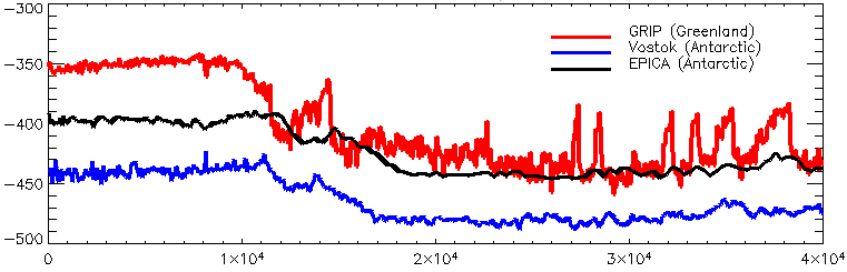
> The Vostok and EPICA Dome C data are deuterium, not O-18
Thanks for noticing. I’ve now done what you could have done, and corrected it. That’s the great thing about wiki; it gets better. Unlike this post, which is still wrong.
I’m sure you’ll all be delighted to know that “The Great Satan” drew the picture you’re relying on.
> while you are earnestly trying to improve the Wikipedia ointment, we still cannot ignore the myriad carcasses of dead flies
You never bother to try to improve it. And (as demonstrated in this post, and many other posts at this point) you all use wiki as your reference, whenever it suits you. But you never dare address the arguments on the GW page.
> Wikipedia is next to useless wherever there is controversy. It is basically a battle of who has the most free time. Since the alarmists have hundreds of millions, billions of dollars in funding for agitprop, they can give communications prizes to fund the spamming of that site
You have no evidence for that, and as far as I know it isn’t true. I know of no-one paid to edit climate, either “skeptic” or otherwise.
> Possibly the earth was…
It is sweet that you want to try and think about these things. But thinking without a body of knowledge will do you know good; you need to start by reading, not writing. Try http://en.wikipedia.org/wiki/Younger_Dryas#Causes
> We skeptics would like to correct Wikipedia errors, as well as correct the noted bias where opposing viewpoints on climate issues are deliberately suppressed by Connolley and crew in violation of NPOV. But we cannot…
How would you know? You never try. You’re happy sitting on the sidelines saying “oh dearie me how terrible the world is”.
> overturning of the THC back in 2004. The stopping of the Gulf Stream is literally impossible, and I knew exactly what Wunsch was talking about
Wunsch is patiently trying to explain that when people talk about THC stopping, they don’t mean the gulf stream stopping, they mean something different. Because, yes, the THC isn’t wind-driven, as indeed its very name suggests. The THC isn’t the gulf stream. Saying that the gulf stream will continue tells you nothing at all about the likihood of THC collapse.
> The YD corresponds with changes in 10Be and 14C production rates
{{cn}}
Ed Grondine speaks of oral traditions of the Assiniboine that give an account of an impact event that’s associated with the draining of one of the Glacial Lakes in the Pacific Northwest. There three glacial lakes at the foot of the Cordilleran Ice sheet. And only two can be suspects in those tribal memories. Lake Columbia, and Lake Missoula.
I don’t know anything about Assiniboine oral traditions. But I do happen to know a fair amount about the Glacial Lakes of the Pacific Northwest. I lived in Spokane Washington for 16 years and am well familiar with the ‘Channeled Scablands’, Otherwise known as the Grand Coulee, of Eastern Washington. I used to spend my weekends flying an ultra light aircraft, and chasing coyotes down in those coulees, pretending I was Luke Skywalker chasing Womprats. It’s an old playground of mine. So I am very familiar with those catastrophic terrains. I am also familiar with the mechanism that caused the sudden drainage of lake Missoula.
During the ice age Glacial Lake Missoula was impounded behind an "Ice Dam" when a tongue of the Cordilleran Ice Sheet called the Purcell lobe extended down south far enough that it formed and ice damn that blocked the south fork of the Clark Fork River in Northern Idaho. Lake Missoula filled and drained many times during the ice age in a repeating cycle. The Glacier would advance, blocking the river and backing up the waters of Lake Missoula. When the lake level would get high enough that the ice damn couldn’t hold back the pressure of all that water the damn would fail, releasing a catastrophic flood downstream. The glacier would advance again, blocking the river again, and the cycle would repeat. Judging by the number of strand lines from Lake Missoula’s ancient beaches, the cycle may have repeated as many as 40 times during the last ice age. The last time it happened has been dated to about 10,000 years ago.
Another blockage occurred to the west where the Okanogan Lobe of the CIS plugged the Columbia River’s course creating Glacial Lake Columbia; a body of water with a 500 square mile surface area at maximum fill. The same process happened there many times during the ice age as well.
And the biggest of all of the mega floods of the late Pleistocene can also ruled out as being associated with the Younger Dryas event because it dates to too long ago. The Bonneville flood released nearly 1,000 cubic miles of water. And the volume was twice as large as the biggest Missoula Flood. However, unlike the Missoula Floods, the Bonneville Flood occurred over a period of several weeks approximately 17,400 years ago.
The geology of the region has been intensely studied. And the mechanism of the repeated formation, and subsequent ice damn failures of the Glacial Lakes of the Pacific Northwest is well understood. Although the story of how geologists came to understand how it all actually did happen is a very exiting read in itself, so far there has been nothing found in the geological record to indicate any of the often repeated great floods of the Channeled Scablands of Eastern Washington were related to an impact event.
Mr Grondine tells us:
The problem with that statement is that any memories of a time when there was water in either Glacial Lakes Missoula, or Columbia must also be memories of a time when anyplace north of either of them was under the Cordilleran Ice Sheet. And Lake Bonneville is off the suspect list of lakes the first peoples may have remembered because at 17,400 YA it was too long ago.
The use of the term “open Cordillera” is a bit confusing.
All of the Mountain ranges of the western half of the continent extending from Southern Mexico to Alaska, from the Rockies of Wyoming, Colorado, Utah and Montana to the Sierra Nevada, Cascade, and Olympic Ranges of the Western Coastal states, as well as all of the mountain ranges of Western Canada can be described by the broad term “Open Cordillera”. So it’s not clear which Mountains Mr Grondine is referring to with his use of that term. But the Bitterroot Range formed southwestern shores of Lake Missoula. And every thing north of the lake was under the Cordilleran Ice Sheet untill about 10,000 years ago. All of the Canadian Rockies are sometimes called the Canadian Cordillera. But they were under the CIS during the ice age too. And the mountains west of the Channeled scablands and south of the CIS were the Cascades
There couldn’t have been any human settlements north of Glacial Lake Missoula at the time. Because the Cordilleran Ice sheet that blanketed the western half of the northern tier of the continent was every bit as thick and extensive as the Laurentide Ice Sheet that blanketed the Northeastern side of the continent. It was up to two miles thick in places. And it blanketed almost all of western Canada all the way to the Pacific
The CIS extended as far south as the northern shores of glacial Lakes Missoula, and Columbia. The Purcell Trench lobe of the CIS was the lobe that extended still further south to block the Clark Fork River in Northern Idaho with an ice damn impounding the waters of Lake Missoula. And an ice dam formed by the Okanogan lobe of the CIS blocked the Columbia River Channel and impounded the waters of Lake Columbia
An ice damn was required for a glacial lake to fill up. And that only happened during an ice age. So at any time in the past when there was water in Lake Missoula or lake Columbia there was also an extensive ice sheet that made anywhere north of either of them unfit for human habitation.
Simply put: No ice sheet=no ice dam. No ice dam=no glacial lake. Or: Glacial lake=ice dam=ice sheet north of lake=unfit for human habitation.
Unfortunately, even if those oral traditions are accounts of an impact event that’s associated with the draining of one of the Glacial Lakes, the catastrophic damage done to the terrains of the Pacific Northwest by the the great floods was so extensive, and so extreme, that it may have removed all traces of anything but the floods themselves.
@Dennis Cox –
The American Cordillera extends the entire length of the Pacific coast of South America and North America. “Open Cordillera” would therefore apply to what portion was not covered by the CIS.
As to the Sioux, this from Wikipedia agrees with what I happen to know about the Sioux:
The Sioux simply were never in the Cordillera region during that time. They were over 1,000 miles to the east. Ed knows a lot more about tribes than I do, though, so perhaps Ed is aware of something else about their earlier history.
But all this is off topic, anyway.
Steve Garcia
I am wondering if the Cayman Trench topography could indicate a ‘blow out’ of enormous proportions? Since the impact trajectory was from NNW going SSE leaving those Carolina impact craters, the Cayman area would seem to be the ‘front’ of the material receiving the shock wave.
Or perhaps it is antipodal to the actual impact site? It just boggles my mind that such an evident catastrophic site is not speculated upon with determination.
katesisco perhaps you should take a look at: http://cosmictusk.com/davias-presents-to-geological-society-of-america-on-carolina-bays/
The Carolina Bays may indeed be related to an impact into the Laurentide Ice Sheet. But they are too old to be related to the YD event. If they do have a cosmic origin, since there is no shock-metamorphic materials in them, they are definately not the result of a direct hypervelocity impact. But rather, the ejecta from one.
Their orientation points to the location of that proposed impact, not the trajectory of the primary impactor.
If they are related to an impact into the LIS, then they will have formed by secondary impacts of impactites. That being the ejecta consisting of large chunks of ice thrown out from those impacts.
It is extremely doubtful, if not impossible that the Cayman Trench had anything to do with it.