Diverging views

The GISS Temperature Record Divergence Problem

Guest post by Tilo Reber

In connection with James Hansen’s explanation of why his GISS temperature record diverges from that of HadCRUT, I decided to check on the legitimacy of what GISS was doing. Dr. Hansen’s article is here at RealClimate. This is the specific chart of interest:
(click on chart to expand)
In this chart, Dr. Hansen explains how the GISS record is different from HadCRUT.   The essential difference is that there are areas at the poles where GISS has filled in the values by extrapolating from the nearest land based records.   Dr. Hansen created a mask of all the areas that HadCRUT does not cover.  He then applies this mask to the GISS record and deletes the readings for the areas that are masked off.  The resulting chart is marked GISS/HadCRUT mask above.   Dr. Hansen then goes on to provide a graph which shows that the GISS divergence with HadCRUT no longer exists after the missing HadCRUT boxes have been removed from the GISS record.
So far so good.  I think that it is safe to say that the divergence of the GISS record is due to the interpolation and extrapolations at the poles.  Now we need to ask the next question – are the GISS interpolations/extrapolations legitimate.  GISS has 2005 as the hottest year for his surface temperature record.  HadCRUT and the satellite records (UAH, RSS) have 1998 as the hottest year.  So Dr. Hansen compares 1998 to 2005 in his chart, allowing the reader to see why the difference exists.  Of course Dr. Hansen considers that his method produces the more accurate result.
One of the first things that pops out about the charts is how different the top row of polar cells is between the two records.  For example, if one looks at the top row of the HadCRUT 2005 chart, one sees a group of cells directly above Svalbard that are shown as having a cool anomaly in that record.  Then, when one looks up at the same cells in the GISS record, one sees that GISS has the same cells colored to the maximum hot anomaly.  In fact, the cells that HadCRUT has in the top row (polar area) of that record look very different from the top row of the GISS record.  The fact that these cells are so different and that they are accounted for in both records makes me wonder what is going on.  Looking at the GISS site, they say this.

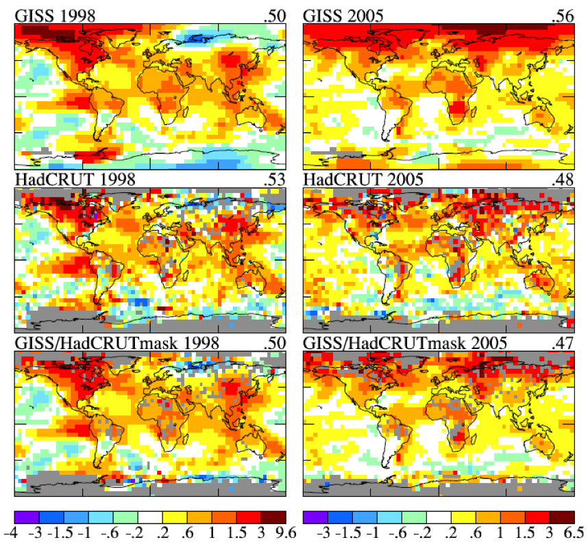
“Areas covered occasionally by sea ice are masked using a time-independent mask.”

So if there is sea ice coverage for any part of the year, GISS will not use SST values to cover those cells for the entire year.  Those cells must be covered by extrapolations from land for that year.  This means that when the area is cover with ice or with water or with part ice part water, it will have it’s anomaly extrapolated from land, regardless.  HadCRUT, on the other hand, does not extrapolate their coverage.  But they will use SST values for a cell when SST values are available for part of the year.  If the area is covered with ice for the entire year, HadCRUT will not assign it a value.  Therefore we get polar areas that are covered by extrapolation by GISS and not covered at all by HadCRUT.

When we look at the HadSST2 record, we see that the cool cells that show up above Svalbard in 2005 are consistent with the numbers in that record.   And these then go  into creating the sea surface portion of the HadCRUT3 temperature record.  So, obviously, how cells are filled with data can have a profound effect on the anomaly value that those cells have.  This leads one to wonder if extrapolations at the pole are legitimate.  I decided to look at some of the northern Russian stations, at the GISS site, that show up as being so hot in the 2005 version of the GISS chart when compared with the 1998 version of the chart.  I found that those big changes are in fact represented in the individual records – especially for the coastal stations.  Here are three of them.

Kanin Nos:   68.7 N, 43.3 E.

1998 Annual Mean –   -3.39

2005 Annual Mean –   0.60             1998 – 2005 delta    3.99 C

Ostrov Vize:   79.5 N,  77.0 E.

1998 Annual Mean – -14.99

2005 Annual Mean – -10.79            1998 – 2005 delta   4.2 C

Gmo Im.E.K F:  77.7 N,  104.3 E.

1998 Annual Mean –  -15.96

2005 Annual Mean –  -12.67           1998 – 2005 delta   3.29 C

For comparison, let’s look across the Arctic ocean and see what was happening in Canada and Alaska at the same time.

Eureka, N.W.T.:  80.0 N, 85.9 W.

1998 Annual Mean –  -17.38

2005 Annual Mean –  -17.34           1998 – 2005 delta   0.04 C

Barrow, Ak.:     71.3 N, 156.8 W.

1998 Annual Mean –  -8.80

2005 Annual Mean –  -10.44           1998 – 2005 delta   -1.64 C

So it seems that the North American side of the Arctic changed little, or even got cooler between 98 and 05, the Russian side warmed considerably.  Why is that?  I think that this ice cover map gives us the answer.  As is immediately apparent, the coastal ice cleared out far earlier in 2005 in northern Russia than it did in 1998.  This is even though the rest of the globe was slightly warmer in 1998 than in 2005.  When dealing with coastal stations, removing the ice and exposing the water is like taking the hatch off a heating source for the coastal thermometers.  For stations that are in areas where the temperature is well below zero, exposing the immediate area of that thermometer to a surface that is above zero, changes everything.  Looking at Ostrov Vize, we see that it is a small island, and therefore even more subject to changes in coastal sea ice.  And when we compare 1998 months on this island with 2005 months we can see that there are differences in some of the monthly means that are larger than 10C.  Even a partial ice cover as opposed to a complete ice cover will supply the stations with more heat.

So I think that we can safely say that the huge change in the anomalies of Russian coastal stations is mostly due to coastal sea ice changes.  In fact, if we look at stations further inland in Russia, the coastal effect begins to decline.  With this in mind, we need to ask if the GISS extrapolations of land based stations, particularly coastal stations,  to the poles is appropriate.

The answer would seem to be that it is not, and the Svalbard case makes this perfectly clear.  There we had a case where the SST anomaly was actually cool, and yet the land based extrapolation actually turned those sea based cells more than 3C hotter.  Reaching across the Arctic Ocean with temperatures that are the result of a coastal sea ice effect cannot give valid answers for what the temperature anomalies away from those coastal stations should be.  In fact, taking the variation that is represented by those coastal stations and extrapolating into the interior of Russia is also not appropriate, because the interior areas did not undergo the magnitude of temperature change of the coastal stations.

Looking at the SST temperature  anomalies that NOAA uses for 1998 and 2005 it again looks like nothing exceptional was happening in the Arctic (Note, the chart will not retain the months that I selected; so use your own sample months and they will plot).  It seems, from this analysis, that GISS polar extrapolations and interpolations are likely to simulate large variations away from the Arctic coasts that are really only present as changes at the Arctic coasts.  And the GISS divergence from HadCRUT, as well as from UAH and RSS are likely to be errors instead of enhancements.

0 0 votes
Article Rating
149 Comments
Oldest
Newest Most Voted
Inline Feedbacks
View all comments
January 29, 2010 10:43 am

I find the errors that are increasingly being highlighted deeply depressing. It is clear that some organisation need to go back to square one on the global temperature record starting with raw data froma much larger sample than is used today.
Lots of not very exciting number crunching but vital if we are going to get a decent global record

Mike Ramsey
January 29, 2010 10:51 am

[snip] What is the mystery?
Mike Ramsey

Mike Bryant
January 29, 2010 10:53 am

The butchers still have their thumbs on the scales….
Fortunately, scales of a different sort are falling from
the eyes of the misled.

Slabadang
January 29, 2010 10:54 am

The systematic efforts to manipulate data to get it warmer is so obvious!
Mr Hansen is NOT a scientist. He is an activist acting as scientist. Embarrassing for NASA and the whole American state. [snip -OTT]
Is there any list anywhere were I/we can protest against this [snip]
Good work Anthony!
REPLY: Thank Tilo Reber, he wrote this piece, not I. -A

DirkH
January 29, 2010 10:58 am

“Colin Aldridge (10:43:35) :
I find the errors that are increasingly being highlighted deeply depressing”
I find it highly entertaining to see explanations like those from E.M.Smith or Tilo. Maybe because i’m a programmer and often have to reverse engineer other peoples mistakes. Dismantle it all! I wanna see how the deception worked! (past tense because it won’t ever work again.)

Anton Eagle
January 29, 2010 11:01 am

And again, I am forced to wonder why “climate science” can’t restrict itself to using raw data. In my field, Medical Physics, where inaccurate data/results can kill people, if I used anything other than raw pristine data I would be laughed out of the room.
If temperature stations are providing data you can’t trust… its not appropriate to guess at how to “correct” them. If you do… you’re just guessing. Use good data, throw out bad data. If you need data in a certain area to complete your picture of global temperatures, then improve the way in which you gather that data so that its reliable. Don’t try to fix data that isnt reliable.
Sheesh… this isn’t that complicated. Do it right, or don’t do it at all.
-Anton

Andrew P
January 29, 2010 11:02 am

Very interesting. Has this been addressed anywhere in the literature?
If extrapolating coastal stations which sea the greatest temperature change causes bias, then if sea ice stabilizes or perhaps increases the next decade we should expect the divergence between GISS and HadCrut to remain the same or shrink. Some good reason to think sea ice will stabilize or increase given the -PDO which seems to correlate with a colder arctic and with sea ice if you use a lag time.
Now to explain the bigger divergence between land and satellite, is that just due to the greater coverage of HadCrut and GISS over the poles?

R.S.Brown
January 29, 2010 11:02 am

It looks like it will be tough for GISS to make any reliable statement
about Northern Hemispheric temperatures this winter due to their
non-function equipment way up north. They’ve lost the temperature, pressure, and winds data:
http://www.arctic.noaa.gov/gallery_np_weatherdata.html
At this same site you’ll see NOAA’s little notice that “The ice
mass balance buoy has stopped transmitting (Aug. 17, 2009)”

According to Environment Canada, the Polar and sub-polar ice coverage is extensive despite the “unprecedented” warm air temperatures allowed in by the Arctic Oscillation in December
and early January:
http://www.weatheroffice.ec.gc.ca/data/analysis/350_50.gif
North Pole Weather Data from 2009 Deployment
Tuesday January 26, 2010
Weather data plot
Ice-temperature plot
Map of station drift
Weather plot: This plot presents air temperature, air pressure, and winds measured by the meteorological station. No radiometer was deployed this year. The weather station sensors are working intermittently (Nov. 20, 2009).

Jeff Kooistra
January 29, 2010 11:03 am

Well, since inspecting and verifying the integrity of the actual thermometer stations from which their data comes is low on the priority list, I guess I’m not surprised that looking around at the local conditions around the world when they massage data isn’t too high on the list, either.

Erik in Cairo
January 29, 2010 11:04 am

I’d like to see a similar comparison for 2009. As a layman, I’ve been wondering how the Northern Hemisphere could have had a mild summer and a frigid winter, and yet the planet as a whole would have near record-setting average temperatures. One would have assumed that the people down south of the Equator would have noticed the presumably high temperatures there before last week’s NASA news release.

January 29, 2010 11:18 am

Perhaps the reason it is not warming as predicted, is because the entire premise of warming from 1975 to 2000 is flawed. A few cold winters (but not abnormally cold) from 1975 to 1985 produced a temperature trend that appeared to be global warming. This is based on hadCRU data; I have not yet done the analysis using GISS data.
http://sowellslawblog.blogspot.com/2010/01/cold-winters-created-global-warming.html

Gareth
January 29, 2010 11:21 am

Why all the manipulation at the heart of global ‘temperature’ taking? Is there something wrong with the raw data??? 😀
Just think; If, say 15-20 years ago, rather than burying their heads in computer code and “adjustments” the likes of Dr. Hansen and those that ended up at CRU had said “The surface station network needs massivly improving!” they could have surely gathered a bit of political muscle to fund a good quality global network of surface stations.
As it is they are working backwards – they take a set of stations that are haphazardly distributed and maintained to varying degrees of quality and try to massage a credible temperature record out of it. Perhaps due to successful scaremongering getting them plaudits and ears of politicians they decided the setting up of a decent network was not neccessary. That they could get all they need to from computers.

Dan in California
January 29, 2010 11:22 am

Are there any recent (post 1950) examples of GISS or CRU or NOAA adjusting the data downward? I’ve been reading about a lot of adjustments and they all appear to be upward. It seems to me that there should statistically be both upward and downward adjustments.

Bill Marsh
January 29, 2010 11:22 am

I guess the choice now is to ascribe this to either intentional manipulation to support a predetermined position or incompetence. I wonder which Dr Hansen would like to embrace?

Richard Wakefield
January 29, 2010 11:22 am

This filling of gaps in temperature records has major problems. I now have all of Ontario and decided to look at what is happenning in Southern Ontario. I’m findind that stations close by, within an hours’ drive of each other, have very different temperatures for the same day, more than 5C difference in some cases! The differences seem to be more pronounced in the winter than in the summer. See Appendix I in my new report: http://www.scribd.com/doc/25995131/Ontario-Surface-Temperature-Trends-no-Warming-happening
I’m finding for all of Ontario the same thing as the Belleville example. No warming at all but a narrowing of the variation with summers actually cooler now than in the 1920’s.
I have more to add to this report later today.
Next report will be British Columbia.

Mick (Down Under)
January 29, 2010 11:25 am

Erik in Cairo (11:04:23) :
One would have assumed that the people down south of the Equator would have noticed the presumably high temperatures there before last week’s NASA news release.
Well it’s been pretty cool here in N.Z. this ‘summer’. Can’t speak for anywhere else in the S.H. but my guess is that the massaged data will show a heatwave for NZ and the entire SH

Ray
January 29, 2010 11:26 am

Climatology is an Art, it is not Science.

David S
January 29, 2010 11:29 am

This is one of the reasons why I oppose extrapolating data from one area to another. Basically it’s just a guess. Let me illustrate an extreme example. Suppose we wanted to use only one thermometer to monitor earth’s temperature so we picked one that was very centrally located, i.e. at the geometric center of the earth. We would find that the earth’s temperature today is a balmy 7000 degrees C. (Or according to Al Gore it would be millions of degrees.)

Retired Dave
January 29, 2010 11:30 am

Good job – more fiddles as we suspected all along.
A bit off topic, but here in the UK – this is in the Daily Telegraph today.
http://www.telegraph.co.uk/earth/earthnews/7101004/Water-vapour-is-a-major-cause-of-global-warming-and-cooling-find-scientists.html
I don’t suppose that any of us suspected that Water Vapour was a greenhouse gas!!!!!!!!!! after all it isn’t even listed in the IPCC list of GHGases.
Just in case you are tempted to misunderstand – the last paragraph was an attempt at humour.

KeithGuy
January 29, 2010 11:31 am

You have to give Hansen some credit for the ingenious ways he finds to “refresh the parts others can’t reach”.
-reference to an old Heineken advert.

PJB
January 29, 2010 11:31 am

I was a convinced and concerned warmist until I saw a copy of the Vostok ice core data (temp and CO2) back in 2005 and started to question the “science”.
With the climategate e-mails, I took quite a hail of abuse from posters (where I post habitually) when I broached the subject but with each revelation, the objections got fewer and less strident.
Anthony and the rest of the “Realists” are to be commended and thanked for their diligence and forth-rightness in this area. We have been spared an economic and psychological nightmare.
In future references, your efforts will be well appreciated by our children.

Richard Wakefield
January 29, 2010 11:32 am

Since this article is looking at 1998 with 2005, I’d like to point out that in Southern Ontario 1998 was the “hottest” year of the average of the yearly mean temperatures. But when I looked at the daily temps and compared 1998 to other years I found that this was caused by not so cold winters in Dec and Feb, warmer spring and Oct temps, but NO CHANGE in summer temps. 1998 wasn’t the “hottest” year on record at all, it just happened to be a warmer spring and some not so cold days in the winter, nothing more.

Layne Blanchard
January 29, 2010 11:33 am

Send a copy to Osama too…..

john a
January 29, 2010 11:35 am

Why don’t these people simply provide temperature records for the areas where they have thermometers, and leave the unmeasured areas blank?
It doesn’t add any value at all to our understanding of climate to make up readings, regardless of whether someone is following reasonable rules, just to make a map appear filled in.
Why would scientists waste their time doing this?

Mom2girls
January 29, 2010 11:36 am

Butcher with his finger on the scales is probably the most accurate description I’ve seen. It’s why they can never, ever allow the raw data to be seen. It’s why they have to throw out stations that do NOT have UHI effects.
This isn’t science, it’s dogma.
It’s the climate version of Reefer Madness.

Bill Marsh
January 29, 2010 11:38 am

David S (11:29:15) :
I suggest using two placed at opposites sides of the globe – one in the Himalayas one in the Amazonian jungle.
Wait, maybe 4, with the above two and one in Antarctica and one at the NP.
Then we can extrapolate the temps world wide from there.

AdderW
January 29, 2010 11:38 am

USA Today:

Study: Water vapor may help ‘flatten global warming trend’
By Doyle Rice, USA TODAY
Why the Earth’s surface temperature hasn’t warmed as expected over the past decade continues to be a puzzle for scientists. One study out earlier this month theorized that the Earth’s climate may be less sensitive to greenhouse gases than currently assumed.
Another surprising factor could be the amount of water vapor way up in the stratosphere, according to a new study out Thursday in the journal Science.

Richard Wakefield
January 29, 2010 11:40 am

The bit about opening the water is also important. It tends to moderate the temperatures even more. It forced summers to be cooler and winters to be warmer. In Appendix I of my report I compared Port Hope daily temps to matching days at Belleville to see what differences there was in each day. I was amazed at the moderating effect Lake Ontario has on temperatures. Port Hope is right on the lake, yet Belleville only a hour or so from Port Hope, is not far inland from the lake. Yet, the temperature swings for Belleville is larger than Port Hope, with the winter having more deviation at Belleville than at Port Hope. Thus closing stations away from the Great Lakes, keeping stations on the lakes, will tend to show a warming trend where none exists.

January 29, 2010 11:47 am

Gents, learn to work with the KNMI climate explorer. Check its results here.
HadCRUT Arctic data 66-90N, CRUTEM+HadSST:
http://climexp.knmi.nl/data/icrutem3_hadsst2_0-360E_66-90N_na.png
No net change between 1940s and present, natural cycle related to AMO oscillation.
Compare with combined station+SST data from GISS for the same area: the 1970-2005 warming is much more pronounced
http://climexp.knmi.nl/data/igiss_temp_250_0-360E_66-90N_na.png
Now lets compare only the ground stations: CRUTEM vs GISS
http://climexp.knmi.nl/data/icrutem3_0-360E_66-90N_na.png
http://climexp.knmi.nl/data/igiss_temp_land_250_0-360E_66-90N_na.png
Quite similar, since there are relatively few stations and both datasets use them all.
So the difference must be caused by SST data.
HadSST ocean data from CRU/Hadley:
http://climexp.knmi.nl/data/ihadsst2_0-360E_66-90N_na.png
No net change between 40ties and present.
AFAIK, GISS uses NOAA ERSSTv2 dataset, which is quite different and features beautiful hockey stick:
http://climexp.knmi.nl/data/iersstv2_0-360E_66-90N_na.png
Anthony, please make a thread about the KNMI Explorer, since it is beautiful tool. I have compared for example rural Armagh and Lomnicky peak Observatory temperature record with MSU data for given grids and found excellent agreement.
http://climexp.knmi.nl/selectfield_obs.cgi?someone@somewhere

davidc
January 29, 2010 11:48 am

Erik:
“One would have assumed that the people down south of the Equator would have noticed the presumably high temperatures there before last week’s NASA news release”
No, a central point in this scam is that no-one can notice anything. Any personal observation is irrelevant because of “local” effects. Hence the invention of the “global” temperature, determined not by observation but by algorithm. And if anyone could actually experience this global temperature, the changes are so small (less than 1C in a century) that they couldn’t possibly be noticed against the background variation (where I live about+/- 10C each day).

D. King
January 29, 2010 11:51 am

The Game of divergence can only be played as long
as people’s perceptions of reality can be manipulated.
We have reached that tipping point. AGW proponents
are beginning to look incompetent. Soon they will
look profoundly incompetent.

January 29, 2010 11:51 am

This is yet further evidence that “global” temperature is a meaningless concept.
It is impossible to say to what extent any particular area will warm if the average goes up or any particular area will cool if the average goes down. The average can go up while some areas cool and vice versa. There is nothing global about it other than the fact that the meaningless figure is calculated by playing with initial measurements that are taken from (a small number of) places spread around the globe.

Lichanos
January 29, 2010 11:58 am

a (11:35:36) :
Why don’t these people simply provide temperature records for the areas where they have thermometers, and leave the unmeasured areas blank?
It doesn’t add any value at all to our understanding … just to make a map appear filled in.

Interpolation is a technique to “fill in” blank spots in the data. It is very useful, and sometimes essential. If you are a mining engineer, it helps you make rational decisions on where to invest money in digging, even though you have limited data. If you fail to find anything, you might be out of a job…
Problem here is we are not making decisions on where to invest – we are trying to understand a complex system. And there is little feedback to those who are doing the interpolating. It’s one of the pitfalls of our computer age – it is so easy to run algorithms to “smooth” the statistical surface.
Leaving blank spots on the map looks quaintly archaic, but it’s really a pretty darn good idea!

Bernie
January 29, 2010 12:00 pm

This is intriguing.
It would be more persuasive if you could show exactly how the temperatures inland differ from those on the coast in Russia.
Also, what pattern do you see in the overall period from 1998 to 2009?
It certainly seems odd to extrapolate land temperature anomalies on to the ocean.
How well covered is this area by the satellite record?

DEK
January 29, 2010 12:03 pm

Good for the Hadley Center. We should obviously believe everything they tell us now…. oops sorry, I forgot, they are duplicitous, lying, cheating, American hating, God hating, environmentalist, lefty, communist, child manipulating… and the worst… Europeans! My God! The sky is falling!

Lichanos
January 29, 2010 12:04 pm

BTW, if we assume that the divergence is an error on the part of GISS, how significant an error is it? The plots at Hansen’s house don’t look like more than 0.1 degree, and the trends are close.
Interesting piece, but is it a knock against the overall GISS argument, aside from evidence of their self-serving tendencies when it comes to data manipulation?

davidc
January 29, 2010 12:08 pm

Nitpick on presentation:
In
1998 Annual Mean – -15.96
2005 Annual Mean – -12.67 1998 – 2005 delta 3.29 C
“-” has three different meanings: first a separator, then a sign indicating the negative value of the following number, then a sign that seems to mean (in conjunction with the modifier “delta”) that the temperature in the year on the right (not the number itself) is to be subtracted from the temperature in the year on the left to give the result -12.67-(-15.96)=3.29.

January 29, 2010 12:08 pm

Not that I’m mounting a defense of his method, but it is worth pointing out that the polar regions are but a very small part of the whole.

DirkH
January 29, 2010 12:16 pm

“DEK (12:03:19) : ”
You’re one of the 3-letter-trolls, right? Is MJK a flatmate of yours?

January 29, 2010 12:17 pm

Andrew P.
“Very interesting. Has this been addressed anywhere in the literature?”
Not that I’m aware of Andrew. It would be nice if someone like Pielke did a more complete statistical job than I have done. I feel solid about what I have found in a qualitative sense. But it would be nice to get it wrapped up quantitatively as well.

Andrew30
January 29, 2010 12:22 pm

lichanos (11:58:00) :
“Problem here is we are not making decisions on where to invest ”
Actually, I think that is exactly what ‘we’ are doing.

January 29, 2010 12:23 pm

Roger Sowell:
“A few cold winters (but not abnormally cold) from 1975 to 1985 produced a temperature trend that appeared to be global warming.”
Roger, look at the ENSO transition that happened right around 1977. Both before and after.
http://www.esrl.noaa.gov/psd/people/klaus.wolter/MEI/ts.gif

January 29, 2010 12:27 pm

I have a silly OT question. It is so rudimentary that I have to wonder if I am missing something… Here are two ubiquitous graphs in the climate change debate:
First is the climate anomaly graph since 1880:
http://upload.wikimedia.org/wikipedia/commons/f/f4/Instrumental_Temperature_Record.png
Next is the “Spaghetti Graph”:
http://upload.wikimedia.org/wikipedia/commons/b/bb/1000_Year_Temperature_Comparison.png
Ok, now follow this simple line of reasoning and tell me where I am wrong.
1) The anomoly at 2000 is roughly +0.4 for both graphs.
2) The lead to the conclusion that the 0-line in very near to or equal in both graphs.
3) The Spaghetti Graph shows that out of all the 1100 years shown, only the last part of the 1900s registered a positive anomaly from the chosen mean.
4) “Zooming in” using the 1880-2000 graph we see that other than a brief stint in 1940, the global climate failed to climb above mean until about 1979.
5) So… here is the head slap moment.. does that mean that, by their own admission, the global temperature has only been above historic mean for about 35 of the last 1100 years?

January 29, 2010 12:27 pm

NASA had a lot of practice manipulating, distorting or hiding data before the events exposed by Climategate.
We parted way in 1972 because NASA didn’t like experimental observations that showed:
a.) Severe mass fractionation of Xenon (Xe) isotopes mixed with excess Xe-124 and excess Xe-136 from a supernova at the birth of the solar system [“Xenon in carbonaceous chondrites”, Nature 240 (1972) 99-101].
http://www.omatumr.com/Data/1972Data.htm
b.) Mass fractionation of Krypton (Kr) and Xenon (Xe) isotopes in the solar wind material implanted in lunar soils [“The role of isotopic mass fractionation in the production of noble gas anomalies in lunar fines from the Apollo 15 mission”, Third Lunar Science Conference, vol. 2 (1972) 1927-1945].
http://www.omatumr.com/Data/1972Data1.htm
With kind regards,
Oliver K. Manuel
Former NASA PI for Apollo
Emeritus Professor of
Nuclear & Space Sciences

DirkH
January 29, 2010 12:27 pm

“Leif Svalgaard (12:08:57) :
Not that I’m mounting a defense of his method, but it is worth pointing out that the polar regions are but a very small part of the whole.”
The polar regions are very important for two reasons:
1. Humidity should be very low there, especially in Antarctica. How does this affect the water vapour greenhouse effect?
2. Temperature is very low, so much less LWIR should be radiated upward.
In both ways, the icecaps behave very differently from the rest of the globe. The AGW people always pointed out “Global Warming comes stealthily, you won’t notice because the poles are most affected”. This could explain why they have such a big interest in NOT getting real measurement values from up there.

January 29, 2010 12:29 pm

Dan in California:
“It seems to me that there should statistically be both upward and downward adjustments.”
I agree with you Dan. Have a look at this adjustment chart from USHCN.
http://cdiac.ornl.gov/epubs/ndp/ushcn/ts.ushcn_anom25_diffs_urb-raw_pg.gif
At one time I had a link that broke it down by the different adjustment types. And they were all up.

bryan
January 29, 2010 12:29 pm

How do those same Russian coastal stations compare between 2005 and 2007 when sea ice reached its “historic Minimum” levels. Shouldn’t this have lead to a 2007 that would be similarly proven statistically warmer than 2005?

Tom
January 29, 2010 12:31 pm

The folks at NASA, have also decided that heavy-lift capability is not important for the U.S. space effort. Admittedly, I am not a rocket scientist but this decision does not make sense to me. Why are the leaders of these agencies so confused about their goals and missions? Money-nuts-both? How did these people get where they are today? The more I learn the less I understand…

Harry
January 29, 2010 12:36 pm

In my non-scientific study of driving my car that has a themometer readout in the rear view mirror. I live near a small lake…depending on the weather there is anywhere from a 1-5 degree temperature difference between my house and the grocery store 1.8 miles away.
Then if I go to GISS and put get a list of ‘reporting stations’ near me I get this one listed as ‘rural’.
47.2 N, 122.0 W 425742060030 rural area 1913 – 2009
It’s right in the middle of a nice subdivision of relatively new homes. It’s not rural anymore.
Earth to NASA…extrapolating temperature anomalies over large areas based on the quality of your data is impossible.

DirkH
January 29, 2010 12:38 pm

“Tom (12:31:29) :
The folks at NASA, have also decided that heavy-lift capability is not important for the U.S. space effort. ”
Big O deep sixed the Constellation program.

Herman L
January 29, 2010 12:46 pm

Slabadang (10:54:31) :
The systematic efforts to manipulate data to get it warmer is so obvious!
Mr Hansen is NOT a scientist. He is an activist acting as scientist. Embarrassing for NASA and the whole American state. [snip -OTT]
Is there any list anywhere were I/we can protest against this [snip]
Good work Anthony!
REPLY: Thank Tilo Reber, he wrote this piece, not I. -A

It’s interesting that you would reply to this comment without correcting the assertion that James Hansen is not a scientist. Dr. Hansen has a Ph.D. in Physics, and is widely published in scientific journals on climate science, and his work is widely cited in other climate scientists works. He was elected to the National Academy of Sciences more than ten years ago. He is a scientist. Instead, you write to inform the author of the post that he should thank Tilo Reber who, if he is a professional scientist, sure does an excellent job of hiding that fact from Internet search engines. Can you tell us more about this guest author of yours?
REPLY: Oh please. Here we go again with your troll word play. He makes a personal opinion. By your logic should I then snip any personal opinions you don’t like? Shall I snip yours? He is right though, Hansen IS an activist. He got arrested for his activism last year, but you neglected to mention that.
http://wattsupwiththat.com/2009/06/23/dr-james-hansen-of-nasa-giss-arrested/
Tilo’s right here, ask him questions if you like. -A

January 29, 2010 12:47 pm

Bah, ignore that… it was head slap indeed. Both are zeroed to 1961-1991 mean.

Will
January 29, 2010 12:50 pm

If it’s worth anything I can testify to the tremendous heating effect of open water. Earlier this winter I had -6F at my house which is 6.5 miles inland, and +15F at work which is a couple hundred yards inland. It does require dead calm and clear sky to produce that steep of a gradient. (Anchorage Ak)

January 29, 2010 12:50 pm

lichanos:
“The plots at Hansen’s house don’t look like more than 0.1 degree, and the trends are close.”
The divergence since 1998 is about .12C. But then the entire AGW trend since 98, as specified by the IPCC, should only be .24C. The important thing is that people who support AGW continue to point to GISS to show that we still have warming and to claim that 2005 was the warmest year.

boballab
January 29, 2010 12:52 pm

Actually this was known by Hansen and the CRU, they talked about this in the emails:

Phil Jones wrote:
Ben,
CRU doesn’t have an infilled land database at the 5 by 5 degree resolution.
We do at the 0.5 by 0.5 degree resolution though. It would take a bit of work to average these together to the coarser resolution, but it ought to be possible.
We have a new version of this (CRU TS 3.0) that Ian Harris (Harry) is finishing off. It runs from 1900 to 2006. It doesn’t take care of variance issues, so will have problems when in regions with poor data earlier in the 20th century. Should be OK though from 1950, if you want to start then.
Harry is i.harris@xxxxxxxxx.xxx. I think the temperature is finished, but Nathan could check. I’m away now till the HC meeting in Sweden and Spain. Another option is to use the infilled 5 by 5 dataset that Tom Smith has put together at NCDC. All infilling has the problem that when there is little data it tends to revert to the 1961-90 average of zero. All infilling techniques do this – alluded to countless times by Kevin Trenberth and this is in Ch 3 of AR4. This infilling is in the current monitoring version of NCDC’s product. The infilling is partly the reason they got 2005 so warm, by extrapolating across the Arctic from the coastal stations. I think NCDC and the HC regard the permanent sea ice as ‘land’, as it effectively is.
As a side issue , the disappearance of sea ice in the Arctic is going to cause loads of problems monitoring temps there as when SST data have come in from the areas that have been mostly sea ice, it is always warm as the 61-90 means are close to -1.8C. Been talking to Nick Rayner about this. It isn’t serious yet, but it’s getting to be a problem. In the AR4 chapter, we had to exclude the SST from the Arctic plot as the Arctic (north of 65N) from 1950 was above the 61-90 average for most of the years that had enough data to estimate a value.

http://www.eastangliaemails.com/emails.php?eid=795&filename=1178107838.txt
Notice that they deleted out data from before the reference period of 61-90 becuase it was warmer.

From: Phil Jones
To: James Hansen
Subject: Differences in our series (GISS/HadCRUT3)
Date: Tue Jan 15 13:17:19 2008
Cc: gschmidt@xxxxxxxxx.xxx
Jim, Gavin,
Thanks for the summary about 2007. We’re saying much the same things about recent temps, and probably when it comes to those idiots saying global warming is stopping – in some recent RC and CA threads. Gavin has gone to town on this with 6,7, 8 year trends etc. What I wanted to touch base on is the issue in this figure I got yesterday. This is more of the same. You both attribute the differences to your extrapolation over the Arctic (as does Stefan). I’ve gone along with this, but have you produced an NH series excluding the Arctic ? Do these agree better?
I reviewed a paper from NCDC (Tom Smith et al) about issues with recent SSTs and the greater number of buoy type data since the late-90s (now about 70%) cf ships. The paper shows ships are very slightly warmer cf buoys (~0.1-0.2 for all SST). I don’t think they have implemented an adjustment for this yet, but if done it would raise global T by about 0.1 for the recent few years. The paper should be out in J. Climate soon. The HC folks are not including SST data appearing in the Arctic for regions where their climatology (61-90) includes years which had some sea ice. I take it you and NCDC are not including Arctic SST data where the climatology isn’t correct? You get big positive anomalies if you do.
Some day we will have to solve both these issues. Both are difficult, especially the latter!
Cheers
Phil

http://www.eastangliaemails.com/emails.php?eid=854&filename=1200421039.txt

January 29, 2010 12:57 pm

Leif:
“Not that I’m mounting a defense of his method, but it is worth pointing out that the polar regions are but a very small part of the whole.”
This is why I never believed that the divergence between GISS and HadCrut could be due to the polar regions alone. But I think that Hansen’s masking experiment more or less proved that it was the difference. This means that all of the divergence had to be due to a very small area. And that further meant that the small area needed to be radically different. Now we know why it is radically different. It is a coastal sea ice coverage effect that is extrapolated and interpolated far beyond the coast.

jaypan
January 29, 2010 1:06 pm

This good work makes me think about a chain.
Each event is bad enough on its own, but they are building a sequence, where errors in each step go all the way to the final one:
-> Suspicious readings, based on poor station quality (UHI etc.)
-> cherry picking of stations used (south, urban, flatlands)
-> fill-in of blanks with at least questionable methods
-> “adjusting” all of those data
-> manipulate the past
-> select “smart” timeframes to compare
-> get rid of raw data and hide adjustment methods
-> report the results as undisputable science
-> blame man-made CO2 only for those results
-> suppress any questions that may occur
The results may be come out of the computer with 2 decimals, but it’s garbage, nevertheless. Expensive garbage.
Still thinking about chains, other context …

January 29, 2010 1:08 pm

bryan:
“Shouldn’t this have lead to a 2007 that would be similarly proven statistically warmer than 2005?”
I think that it depends more on how early you get ice clearing from the coastal areas than it does on the absolute minimum ice coverage, brian. And of course the contribution of the rest of the globe makes a difference.

carrot eater
January 29, 2010 1:09 pm

Tilo Reber (12:29:15) :
The breakdown of changes to the US mean temperature anomaly due to the different adjustments is given in Menne et al, 2009, in BAMS. There is a net warming due to TOB, a net warming due to other homogenisation, and a negligible effect due to FILNET.
The graphs you’ve seen before are maybe outdated, because they’ve changed the homogenisation method.
But that is all for the US only. Globally, there is a minimal net effect due to homogenisation in GHCN. See Q4 here
http://www.ncdc.noaa.gov/cmb-faq/temperature-monitoring.html
and here
http://www.gilestro.tk/2009/lots-of-smoke-hardly-any-gun-do-climatologists-falsify-data/

DirkH
January 29, 2010 1:11 pm

“boballab (12:52:52) :
[…]
Phil Jones:
In the AR4 chapter, we had to exclude the SST from the Arctic plot as the Arctic (north of 65N) from 1950 was above the 61-90 average for most of the years that had enough data to estimate a value.

Great detective work! …yes that would have shown that there’s no warming, Phil, you did that very nicely, now is that an admission of fraud to receive more grant money or what?

January 29, 2010 1:23 pm

boballab:
“The infilling is partly the reason they got 2005 so warm, by extrapolating across the Arctic from the coastal stations.”
Thanks boballab. Now I know that I’m in agreement with Phil Jones. But I don’t know if that is a good thing. LOL.
I’m not sure that I saw a recognition, on Jones part, of the extreme variation in temperature that is produced in the coastal stations depending on when sea ice opens up.

John Finn
January 29, 2010 1:30 pm

And the GISS divergence from HadCRUT, as well as from UAH and RSS are likely to be errors instead of enhancements.
UAH NoPol readings show 2005 ~0.74 deg warmer than 1998 and a linear temperature increase of ~0.6 deg over the 8 year period. There has also been more summer ice melt since 2000. GISS are probably closer to the true picture than Hadley.

January 29, 2010 1:42 pm

I build artificial intelligence systems intended to simulate human thought processes including high level complex mathematical constructs and how they are impacted by instinctual and emotional motivators. I built a two sided model to simulate information exchange between different scientific disciplines. This revealed an unexpected end state feedback loop that constantly corrupted the information exchange. I’ve run the simulation thousands of times and am at a 95% confidence level that the observed feedback loop is the principle component causing a divergence between logic, results, and data corruption that posters above keep asking about. While there is some variability in output, a typical example output follows:
Climatologist; I have a system of undetermined complexity and undetermined composition, floating and spinning in space. It has a few internal but steady state and minor energy sources. An external energy source radiates 1365 watts per meter squared at it on a constant basis. What will happen to temperature?
Physicist; The system will arrive at a steady state temperature which radiates heat to space that equals the total of the energy inputs. Complexity of the system being unknown, and the body spinning in space versus the radiated energy source, there will be cyclic variations in temperature, but the long term average will not change.
Climatologist; Well what if I change the composition of the system?
Physicist; see above.
Climatologist; Perhaps you don’t understand my question. The system has an unknown quantity of CO2 in the atmosphere that absorbs energy in the same spectrum as the system is radiating. There are also quantities of carbon and oxygen that are combining to create more CO2 which absorbs more energy. Would this not raise the temperature of the system?
Physicist; there would be a temporary fluctuation in temperature caused by changes in how energy flows through the system, but for the long term average… see above.
Climatologist; But the CO2 would cause a small rise in temperature, which even if it was temporary would cause a huge rise in water vapour which would absorb even more of the energy being radiated by the system. This would have to raise the temperature of the system.
Physicist; there would be a temporary fluctuation in the temperature caused by changes in how energy flows through the system, but for the long term average… see above.
Climatologist; That can’t be true. I’ve been measuring temperature at thousands of points in the system and the average is rising.
Physicist; The temperature rise you observe can be due to one of two factors. It may be due to a cyclic variation that has not completed, or it could be due to the changes you alluded to earlier resulting in a redistribution of energy in the system that affects the measurement points more than the system as a whole. Unless the energy inputs have changed, the long term temperature average would be… see above.
Climatologist; AHA! All that burning of fossil fuel is releasing energy that was stored millions of years ago, you cannot deny that this would increase temperature.
Physicist; Is it more than 0.01% of what the energy source shining on the planet is?
Climatologist; Uhm… no.
Physicist; rounding error. For the long term temperature of the planet… see above.
Climatologist; Methane! Methane absorbs even more than CO2.
Physicist; see above.
Climatologist; Clouds! Clouds would retain more energy!
Physicist; see above.
Climatologist; Ice! If a fluctuation in temperature melted all the ice less energy would be reflected into space and would instead be absorbed into the system, raising the temperature. Ha!
Physicist; The ice you are pointing at is mostly at the poles where the inclination of the radiant energy source is so sharp that there isn’t much energy to absorb anyway. But what little there is would certainly go into the surface the ice used to cover, raising its temperature. That would reduce the temperature differential between equator and poles which would slow down convection processes that move energy from hot places to cold places. The result would be increased radiance from the planet that would exceed energy input until the planet cooled down enough to start forming ice again. As I said before, the change to the system that you propose could well result in redistribution of energy flows, and in short term temperature fluctuations, but as for the long term average temperature…. see above.
Climatologist; Blasphemer! Unbeliever! The temperature HAS to rise! I have reports! I have measurements! I have computer simulations! I have committees! United Nations committees! Grant money! Billions and billions and billions! I CAN’T be wrong, I will never explain it! Billions! and the carbon trading! Trillions in carbon trading!
Physicist; how much grant money?
Climatologist; Billions. Want some?
Physicist; Uhm…
Climatologist; BILLIONS
Climatologist; Hi. I used to be a physicist. When I started to understand the danger the world was in though, I decided to do the right thing and become a climatologist. Let me explain the greenhouse effect to you…

UKIP
January 29, 2010 1:44 pm

http://hadobs.metoffice.com/hadcrut3/diagnostics/monthly/anomaly.png shows UK 1-3c warmer than average in December. This is completely fraudulent. http://www.climate-uk.com tells the true story.

John from MN
January 29, 2010 1:53 pm

Tilo, Anthony or anybody,
I have a different question that seems very pertinent. Why is all the land masses cooler in the hadcrut chart than the giss? Not just the artic. The differences in colors are startling yet the anamoly numbers are not so startling (GISS vs Hadcrut) considering the artic differences in their as well. Are the color charts wrong or the printed anamolies? Sincerely, John…

January 29, 2010 2:00 pm

Good work Tilo,
The offhanded excuse, we extrapolate CRU doesn’t, has always bothered me, but I never dug down into the details. I think most of us have argued consistently against this kind of extrapolation because it was essentially untestable. Now, you have identified a specific problem with extrapolation that makes the flaw obvious. It might be nice to send a copy to Gavin and Hansen and ask them for a comment. Also, It would seem your could also test other years ( if we had hansen’s code for the masking”) and get a nice paper out of it. Or better, Do a fancy Hansenism and check the icemaps before extrapolating.
Perhaps with EM smith running GISStemp with a hansen mask and jeffId
pulling in CRU data and Ice data a nice little study could be done.
Steve

January 29, 2010 2:04 pm

John Finn:
“UAH NoPol readings show 2005 ~0.74 deg warmer than 1998 and a linear temperature increase of ~0.6 deg over the 8 year period.”
That’s possible, John. But the GISS differences are much larger than that. And those differences are extrapolated to the pole.

Andrew30
January 29, 2010 2:14 pm

davidmhoffer (13:42:55) :
That is funny, well done.

wayne
January 29, 2010 2:16 pm

Related to Dr. Hansen’s handling of the grid’s data:
Might read http://www.ems.psu.edu/~fraser/Bad/BadGreenhouse.htm first to get some generalities from AGW proponent’s “science” stories, diagrams, and graphs out of your mind.
Then read http://cdsweb.cern.ch/record/1045824?ln=sv on “Falsification Of The Atmospheric CO2 Greenhouse Effects Within The Frame Of Physics” at CERN. Go to the link to the PDF paper at the bottom of page or directly at http://arxiv.org/pdf/0707.1161.pdf .
If you can not follow the math and physics, at least read “Physicist’s Summary” near page 92 for a summary of what this paper contains. Hope it’s a little enlightening!

carrot eater
January 29, 2010 2:18 pm

Tilo,
I must say that I enjoyed reading this one. I’m not sure about your reasoning, but you do ask a useful question (how good is the GISS Arctic infill).
I think in general it’s best to always show both GISS and HadCru results; if the argument being made specifically requires one or the other but fails if both are shown, then the argument may not be a good one.
In any case, even if you are on to something here, I still think the HadCru global mean is running a bit low. Omitting the Arctic in effect means that you are setting it to warm at the exact same rate as the global mean, which appears unlikely. Perhaps the truth is somewhere in between the two data sets.

George E. Smith
January 29, 2010 2:27 pm

“Interpolate” can be found in any English Dictionary. It fits nicely with Galileo Galilei’s “Dialog on the Two World Systems” Wherin he proves that somewhere in between the end points there must exist some place with any value between those end points.
“Extrapolate” is a swear word; not to be used in polite company.
George

Britannic no-see-um
January 29, 2010 2:30 pm

Its party-time for a computer when given no data and asked to contour it.

January 29, 2010 2:32 pm

John from MN:
Are the color charts wrong or the printed anamolies? Sincerely, John…
John, the colors cover a large range. For example the hottest color can be anything between 3 and 6.5 C anomanly. For me, it’s hard to tell what the effect is accross the rest of the globe. The arctic is so drastic that it was obvious. When Hansen masks off the cells that HadCrut does not have he comes up with a global answer that is very similar to HadCrut. You can follow the link to the RC article. There Hansen has charted the difference when the area coverage is the same. The only thing that bothers me about Hansen’s GISS/HadCRUT mask maps is why some of the cells that remain change value only as a result of other cells being masked off.

bryan
January 29, 2010 2:40 pm

Perhaps we should make it really easy for them. Do away with all reporting stations except for Death Valley Ca. They could then average out the temperatures reported with relative ease and claim thet they had done so due to the lack of stations. The whole would would be basking in the summer in 120deg temps. Talk about warming…WHEW

bryan
January 29, 2010 2:42 pm

meant to say “whole world would” instead of whole would would.

John from MN
January 29, 2010 2:48 pm

Tilo,
Well in the US, Africa, SA, and Europe, basically all the land masses in both the 2005 and 1998 maps, The GISSS is definetly warmer by a large degree than the HaDcrut. You don’t know why? Seems odd there can be that much difference in the land mass temps. John.

KeithGuy
January 29, 2010 2:55 pm

Noticed that Hansen’s printer seems to have a developed a red bias recently.
Here’s a tip Jim! Change the f***ing cyan cartridge!!!

Bulldust
January 29, 2010 3:03 pm

Sometimes I, somewhat cynically, wonder whether Hansen won’t be happy until the entire map is extrapolated from one thermometer situated in his office… next to the A/C vent.
Perhaps I am growing somewhat intolerant with age…

Simplicio
January 29, 2010 3:10 pm

re the post by davidmhoffer
I’m not a physicist or even a railway engineer. I put into the vernacular aspects of science and technology. I really enjoyed your dialogue and I think Galileo would have too. It reminded me a bit of Lewis Carroll.

January 29, 2010 3:10 pm

carrot eater:
Omitting the Arctic in effect means that you are setting it to warm at the exact same rate as the global mean, which appears unlikely. Perhaps the truth is somewhere in between the two data sets.
Your question is valid. Just for something quick and dirty I decided to plot the Amundsen-Scot sation at the south pole. It’s one data point that should be removed from too much of a sea ice effect and that should have a maximum CO2 polar effect. Oddly enough it shows about -0.2C of cooling over it’s 52 year period. But we can’t conclude too much from one station.

Roger Knights
January 29, 2010 3:10 pm

I suspect this means that if the ice extent expands again, there could be a sharper drop in the GISS global temperature than in other data sets. Right?

January 29, 2010 3:44 pm

Quote: Leif Svalgaard (12:08:57):
“Not that I’m mounting a defense of his method, but . . .”
Yes, Leif. Of course not.
With kind regards,
Oliver K. Manuel

January 29, 2010 3:46 pm

>>
davidmhoffer (13:42:55) :
An external energy source radiates 1365 watts per meter squared at it on a constant basis.
<<
Actually the TOA TSI varies with the Sun-Earth distance (assuming a constant solar output) from about 1321 W/m^2 (just after July 1st) to about 1414 W/m^2 (around January 1st). The 1368 W/m^2 value is the average (at about 1 AU or the semi-major axis distance of the Earth’s orbit).
Jim

January 29, 2010 3:47 pm

Roger Knights:
I suspect this means that if the ice extent expands again, there could be a sharper drop in the GISS global temperature than in other data sets. Right?
That should be what happens. I think I can give you an example of that. Take a look at the GISS 98 chart in the article above. Notice that there is a cool Arctic area that has been extrapolated above Russia. Now look at this chart:
http://3.bp.blogspot.com/__VkzVMn3cHA/SDtWvmPzrVI/AAAAAAAAACU/1xl7LBESwbs/s1600-h/Ten+Year+Divergence.bmp
Keep in mind that the different temp sets have different baselines. But you can see that GISS is higher almost everywhere. Now look at it in 98. It’s level is the same as the others and possibly lower. It’s an exercise in eyestrain, but it’s also an indication that the reverse effect applies.

January 29, 2010 3:51 pm

Tilo: Using that mapping features of the KNMI Climate Explorer, I created a few .gif animations for 1998 and 2005, North Polar view (north of 50N), to compare GISTEMP to HadCRUT3+HADSST2 and to compare GISTEMP to the SST dataset GISS uses, which in 1998 and 2005 was the NCDC’s OI.v2 SST data (not the ERSST.v3b data you linked in your post). I also made the base years for anomalies 1998 to 2005. Seemed appropriate.
Something to consider, though. KNMI does not provide HADCRUT3 data. KNMI uses HADSST2 and CruTEMP3 data and merges them themselves because:
http://climexp.knmi.nl/crutem3_hadsst2.html
Other than that the data should be similar. Keep in mind that the polar view skews perspective as the distance from the pole grows.
First animations are of GISTEMP (1200 km smoothing) vs OI.v2 SST anomalies. The GISTEMP smoothing does overwhelm the SST data, but is it significant? Dunno.
GISTEMP vs OI.v2 SST anomalies 1998:
http://i49.tinypic.com/1198nsy.gif
GISTEMP vs OI.v2 SST anomalies 2005:
http://i49.tinypic.com/1gpzic.gif
Next I compared GISTEMP (1200 km smoothing) to the combined HadCRUT3+HADSST2. Note how sparse the Hadley Centre data is over Siberia, parts of Northern Canada, and Greenland.
GISTEMP (1200 km smoothing) vs HadCRUT3+HADSST2 1998:
http://i47.tinypic.com/21o69vq.gif
GISTEMP (1200 km smoothing) vs HadCRUT3+HADSST2 2005:
http://i49.tinypic.com/2lc0axu.gif
This raised the question, is GISS infilling all of the areas missed by the Hadley Centre? The answer is no. To view this, I compared GISTEMP (250 km smoothing) to the combined HadCRUT3+HADSST2 In 1998 and 2005. GISS’s geographic coverage was much better than the Hadley Centre’s. However, keep in mind that the polar view skews perspective with distance from the pole, and the latitudes I illustrated are much greater than the Arctic.
GISTEMP (250 km smoothing) vs HadCRUT3+HADSST2 1998:
http://i47.tinypic.com/9867nm.gif
GISTEMP (250 km smoothing) vs HadCRUT3+HADSST2 2005:
http://i49.tinypic.com/11t4b3c.gif
While this doesn’t provide an answer for the difference between the two datasets, it provides a different perspective.
Also, I have shown that, by comparing GISTEMP and UAH MSU TLT data, the GISS infilling with the 1200km smoothing does add a significant positive bias in parts of the world with sparse surface station coverage, specifically Africa, Antarctica, Asia, and South America:
http://bobtisdale.blogspot.com/2009/06/part-2-of-comparison-of-gistemp-and-uah.html
Does the GISS 1200km smoothing also add a positive bias the Arctic, when compared to UAH MSU TLT anomalies? Yes:
http://i43.tinypic.com/1zp1q8j.jpg
And that graph is from this post:
http://bobtisdale.blogspot.com/2009/06/part-1-of-comparison-of-gistemp-and-uah.html
Regards

DR
January 29, 2010 3:55 pm

Re: John Finn (Jan 29 13:30),
UAH NoPol readings show 2005 ~0.74 deg warmer than 1998 and a linear temperature increase of ~0.6 deg over the 8 year period. There has also been more summer ice melt since 2000. GISS are probably closer to the true picture than Hadley.
John Finn,
The numbers are:
NoPol
2002-2009……….land………………ocean…………land/ocean
…………………… -.17c/dec…….. .0006c/dec……. -.10c/dec
2005-2009……….land………………ocean…………land/ocean
………………….. -1.27c/dec……. -1.14c/dec…….. -1.22c/dec
Hansen is making up temperatures where none are measured. Satellite at least does even if it isn’t 100% coverage of the Arctic. It really is amazing the extent to which some go to defend the indefensible.

rbateman
January 29, 2010 4:14 pm

Somehow, I seriously doubt that Hansen’s extrapolation was an error.
Remove the Arctic Ice Cap and replace with slush.
Switcheroo.

January 29, 2010 4:15 pm

For stations that are in areas where the temperature is well below zero, exposing the immediate area of that thermometer to a surface that is above zero, changes everything.

That is surely the basis for the very strong argument that a lack of polar sea ice is a negative ‘warming’ feedback as more heat is lost when there is no ice.

January 29, 2010 4:24 pm

Punxsatawney Phil (16:15:12),
Yes, on average everyone has less than two legs.

January 29, 2010 4:43 pm

JEROME:
“That is surely the basis for the very strong argument that a lack of polar sea ice is a negative ‘warming’ feedback as more heat is lost when there is no ice.”
If that’s true, then less ice should mean stronger currents. That would be interesting to look into. Of course the reverse side is that more ice means more albedo means less heat is gathered. I’m not sure which is the stronger effect. But a negative feedback does seem possible.

David Alan Evans
January 29, 2010 4:46 pm

bryan (14:40:22) :
I could be wrong, but I believe they moved the reporting station in Death Valley to Badwater which is a ‘hot spot’. All to the good eh?
DaveE.

January 29, 2010 4:55 pm

@ Tilo Reber (12:23:54) :
“Roger, look at the ENSO transition that happened right around 1977. Both before and after.”
First, Tilo, this is an excellent article and thank you for writing it.
Second, as to the ENSO transition in 1977, that is precisely the point – or perhaps entirely beside the point. Whatever caused the colder winters, there is no doubt they did occur. The simple statistical effect from having 1975 as the starting point that alarmists use to show the globe has warmed, with a string of cold winters immediately after that starting point, is all that was required to create global warming. This is a well-known statistical effect, that is, the undue influence on a trend line of starting and ending values in a data set.
Other known effects can explain warmer summers in those cities that show hotter summers and warmer winters, such as Urban Heat Island effect due to increased population, and increased humidity in formerly desert cities such as Tucson and Phoenix in Arizona, USA.
The evidence all leads to one inescapable conclusion: CO2 is not the cause of any changes in the earth’s average global temperature. The entire premise of man-made global warming due to fossil fuel consumption is absolutely false.

January 29, 2010 5:07 pm

Actually the TOA TSI varies with the Sun-Earth distance (assuming a constant solar output) from about 1321 W/m^2 (just after July 1st) to about 1414 W/m^2 (around January 1st).
I actually knew that, but adding it as a variable to the artificial intellgence model caused the simulation of the physicist to increase output verbage by an order of magnitude as he had to include that variable’s effect on each answer to the climatologist. As the end point feedback corruption loop didn’t seem to be affected one way or another, I took it out. There was one outlier however where the climatologist interrupted and insisted that the earth did not in fact spin, but that the sun circled the earth instead and that the observed data supported this. I am going to tweak the climatologist sim to see if I can make him do it again.

barry
January 29, 2010 5:12 pm

UAH satellite record for the poles shows warming trend of 0.44C, a much higher trend than for anywhere else. The anomalies, of course, are generally significantly greater than for the globe.
According to a data set favoured here, the Arctic appears to be warmer than the globe, and warming faster than the globe. Does this not corroborate the GISS extrapolation?
http://vortex.nsstc.uah.edu/public/msu/t2lt/uahncdc.lt

JDN
January 29, 2010 5:29 pm

Tilo: Liked the article. The most effective argument I’ve seen against what you’re arguing is the animation of the loss of “multi-year” ice at the poles. Do you have any comment on those observations? Are they similarly extrapolated or measured directly. Your argument against extrapolation of rising land temperature to the ice cap seems to require that surface temperature over the ice cap remain somewhat constant. But, the depth maps they are presenting argue for warming. Obviously , I suspect their technique given their desire to present the case for warming.

January 29, 2010 5:45 pm

barry:
“Does this not corroborate the GISS extrapolations.”
No, barry, the artic sea ice shore effect that GISS shows is a much larger variation than any actual warming trend at the poles.

January 29, 2010 5:51 pm

JDN:
“Your argument against extrapolation of rising land temperature to the ice cap seems to require that surface temperature over the ice cap remain somewhat constant.”
JDN, in the article I give you a link to the SST dataset that GISS uses. You can have it give you anomaly charts for any month of any year. Try it and you will see that the SST’s are not warming nearly as much as the surface station. The water temperature has gotten slightly warmer up there, but the shore ice effect is making the shore stations much warmer. Look at the stations that I provide a link for and look at the variation. The Arctic SSTs don’t show anything like that much variation.

wayne
January 29, 2010 6:22 pm

Have you ever seen where GISS and others overly report cooling? Not just half the time but ever? Non-randomness in errors strongly implies manipulation, if not pure agenda.

jorgekafkazar
January 29, 2010 6:27 pm

JER0ME (16:15:30) :”That is surely the basis for the very strong argument that a lack of polar sea ice is a negative ‘warming’ feedback as more heat is lost when there is no ice.”
I think your conclusion is right, but not for the reason you cite. The emittance of seawater is 0.993, close to a perfect black body. During the local polar winter, seawater will rapidly freeze. Ice slows the heat loss by both its insulating properties and its low emittance.
Summer conditions are different, of course. Remember, however, that the albedo of seawater is still fairly high at the zenith angles typical of the poles, depending on wind/wave conditions, plankton, time of day, etc. Open water polar albedos of .80 are typical, but not the maximum that can be encountered and often overlap ice albedo.

jorgekafkazar
January 29, 2010 6:29 pm

It is hard to make data where none exists. Oh, wait. Yes, it is. Never mind.

January 29, 2010 7:19 pm

I think your conclusion is right, but not for the reason you cite. The emittance of seawater is 0.993, close to a perfect black body. During the local polar winter, seawater will rapidly freeze. Ice slows the heat loss by both its insulating properties and its low emittance. >
My thought has always been that the above is sensible. during a warming cycle, the amount of ice would decrease. As the heat of transition for ice to water is massive, large amounts of ice would tend to keep the temperature stable. As the amount of ice decreases, the effect on stability would decrease as additional open water increased and could rise in temperature above the freezing point, hence radiating more energy. If you plot the nasa/giss temperature data by latitude zone (flawed data acknowledged) the arctic temperatures fluctuate around the mean by about 4 times the variance at the equator:
http://knowledgedrift.files.wordpress.com/2010/01/global-versus-equatorial-versus-arctic1.png

January 29, 2010 7:56 pm

Anton Eagle (11:01:15) :
If you want to see examples of science waylaid by farse in your own field of “medical physics,” venture (with caution) towards the field of psychology. If physcial health is something based on sound science, “mental health” is something very much like “global warming.”
They say that every cloud has a silver lining. If any good is to ever come of the shambles “global warming” has made of science, it will be because the lessons learned will be applied across the board, to all science, everywhere.

January 29, 2010 8:16 pm

>>
David Alan Evans (16:46:23) :
I could be wrong, but I believe they moved the reporting station in Death Valley to Badwater which is a ‘hot spot’. All to the good eh?
<<
Interesting. The Badwater move was reported by the late John Daly before he died.
One claim made about CO2 warming is that we’ll see the effects first where it is dry–at the poles and in deserts. During the (supposedly) hot year of 1998, Death Valley had a cool year. They’ve apparently “homogenized” the data over the years, so Death Valley’s cool years aren’t as obvious as I remembered. However, the record does show a cooler than average year during 1998. I guess Death Valley didn’t get the memo.
Jim

Jean Parisot
January 29, 2010 8:34 pm

After repeated being told that weather isn’t climate, in condescending tones by the alarmists, I think I am going to start referring to anything based on the surface temperature record as weather. Given the enormous variety of error sources, inconsistent measurement methods, and questionable historical record– what does it measure other then local “weather” phenomenon, how can it ever be normalized to a global value of any useful confidence.

Editor
January 29, 2010 8:44 pm

Can we not simply conclude that all of his “manipulated data” for the Arctic are simply “nonsense”? (Regardless of how he attempts to re-manipulate the raw numbers.)
Anthony: Look at your own web page, in the link for Arctic temperatures:
“Daily Mean Temperatures in the Arctic 1958 – 2008
Daily mean temperatures for the Arctic area north of the 80th northern parallel, plotted with daily climate values calculated from the period 1958-2002.”
1) Hansen is claiming 1.5 to 2 degrees WARMING for (almost all areas of) the Arctic over the recent time frame. Elsewhere, his AGW “profits” at other centers are claiming a rise (degrees per century) of as much as 4 degrees C. (Thus, over a half century) we should see right under 2 degrees C increase.
If we do not see that increase at a measured location, his “manipulations” are exposed – if not as a deliberate fraud – then as a “mistake” or “error” that must be retracted or explained. (In other words, Hansen is directly claiming (here and elsewhere) that the arctic is increasing in temperature by about 2 degrees, so the raw temperatures (away from heat island effects) MUST be measured with that increase.
2) Visually: Look at the 50 plus years of data for 80 degrees: Visually, it’s easiest to simple click on your link, then sequentially, go to every year since 1958. Then to see all the daily temperatures rapidly, use the “Back” browser button to see all of them quickly.
Result? There is NO increase in summer temepratures at all since 1958. NONE.
In winter temperatures, there is great scatter (the fall winter and spring standard deviation is much, much higher than across the summer) but no measured increase.
3) So, where is Hansen’s “manipulated” raw data from? Why is his manipulated data showing an increase not found elsewhere?

Editor
January 29, 2010 8:48 pm

Can we not simply conclude that all of his “manipulated data” for the Arctic are simply “nonsense”? (Regardless of how he attempts to re-manipulate the raw numbers.)
Anthony: Look at your own web page, in the link for Arctic temperatures:
“Daily Mean Temperatures in the Arctic 1958 – 2008
Daily mean temperatures for the Arctic area north of the 80th northern parallel, plotted with daily climate values calculated from the period 1958-2002.”
1) Hansen is claiming 1.5 to 2 degrees WARMING for (almost all areas of) the Arctic over the recent time frame. Elsewhere, his AGW “profits” at other centers are claiming a rise (degrees per century) of as much as 4 degrees C. (Thus, over a half century) we should see right under 2 degrees C increase.
If we do not see that increase at a measured location, his “manipulations” are exposed – if not as a deliberate fraud – then as a “mistake” or “error” that must be retracted or explained. (In other words, Hansen is directly claiming (here and elsewhere) that the arctic is increasing in temperature by about 2 degrees, so the raw temperatures (away from heat island effects) MUST be measured with that increase.
2) Visually: Look at the 50 plus years of data for 80 degrees: Visually, it’s easiest to simple click on your link, then sequentially, go to every year since 1958. Then to see all the daily temperatures rapidly, use the “Back” browser button to see all of them quickly.
Result? There is NO increase in summer temperatures at all since 1958. NONE.
In winter temperatures, there is great scatter (the fall winter and spring standard deviation is much, much higher than across the summer) but no measured increase.
3) So, where is Hansen’s “manipulated” raw data from? Why is his manipulated data showing an increase not found elsewhere?

January 29, 2010 8:49 pm

Quote: Caleb (19:56:59) :
“They say that every cloud has a silver lining. If any good is to ever come of the shambles “global warming” has made of science, it will be because the lessons learned will be applied across the board, to all science, everywhere.”
I sincerely hope that you are right! Astronomy, astrophysics, cosmology, solar and space science desperately need relief from decades of consensus thinking!
With kind regards,
Oliver K. Manuel
Emeritus Professor of
Nuclear & Space Science
Former NASA PI for Apollo

Fluffy Clouds (Tim L)
January 29, 2010 8:52 pm

Anthony…… u suck for RC… no really.
they have this red hot story and you through green house liquid on it (H2O)!
you may be on to the glow bull warming trend .
nice read eah?

Christopher Hanley
January 29, 2010 11:00 pm

The GISTEMP + HADCRUT3 data series 1979 – 2010 show a temperature rise of 0.5°C compared with UAH LT of 0.4°C – RSS is in between.
During that latter period of alleged AGW (i.e. human GHGs being the overwhelming climate driver) there is a slight warming bias in the surface data.
In light of the US ‘adjustments’ (http://www.mcculloughsite.net/stingray/photos/temp_adjust.gif)
and the recent developments, it is the unverifiable period c1945 – 1979 which is very suspect.

January 29, 2010 11:49 pm

>>Actually the TOA TSI varies with the Sun-Earth distance
>>(assuming a constant solar output) from about 1321 W/m^2
>>(just after July 1st) to about 1414 W/m^2 (around January 1st).
>>The 1368 W/m^2 value is the average (at about 1 AU or the
>>semi-major axis distance of the Earth’s orbit).
Would the Earth distance/orbit be coincident with the precession of the equinox?
If so, in 13,000 years time, minimum TSI would be coincident with winter in the N hemisphere, and we would be in for some very cold winters.
.

J.Hansford
January 30, 2010 1:00 am

NASA = Need Another Space Administration. 😉

John Finn
January 30, 2010 3:32 am

DR (15:55:59) :

Re: John Finn (Jan 29 13:30),
UAH NoPol readings show 2005 ~0.74 deg warmer than 1998 and a linear temperature increase of ~0.6 deg over the 8 year period. There has also been more summer ice melt since 2000. GISS are probably closer to the true picture than Hadley.


John Finn,
The numbers are:
NoPol
2002-2009……….land………………ocean…………land/ocean
…………………… -.17c/dec…….. .0006c/dec……. -.10c/dec
2005-2009……….land………………ocean…………land/ocean
………………….. -1.27c/dec……. -1.14c/dec…….. -1.22c/dec
Hansen is making up temperatures where none are measured. Satellite at least does even if it isn’t 100% coverage of the Arctic. It really is amazing the extent to which some go to defend the indefensible.

I’m not sure I understand what your numbers are supposed to show. Is this just a case that if 1998 doesn’t work – try 2002. What next 2010? Both GISS and UAH show arctic warming which appeared to peak in ~2005. If we look at the last 20 years (since 1990) the trends are
UAH NoPol +0.68 deg per decade
GISS 64N-90N +0.78 deg per decade
This is not a terribly robust comparison for a number of reasons but a proper analysis may actually show better agreement. The warmer arctic since 2000 (relative to the 1980s and 1990s) will probably mean that GISS is currently running slightly higher than Hadley. But, as Leif (I think) said the Arctic is only a relatively small region of the earth so this shouldn’t make a large difference.
I’ll say this again. If this is an attempted fudge by GISS in order to show a higher rate of warming then it’s not working very well. In the last 20 years there’s been barely a few hundredths of a degree between the 4 metrics.
Anyway, I wouldn’t worry about it too much because as we’re regularly being told on a number of blogs; the PDO has shifted and the Sun’s heading for a Dalton minimum at least. This is bound to affect the arctic which will, in turn, have a relative ‘cooling’ effect on the GISS record. Swings and roundabouts.

January 30, 2010 3:53 am

davidmhoffer (13:42:55) :
David, great piece of reading and Tilo, great piece of investigation.

Paul
January 30, 2010 4:31 am

” UKIP (13:44:08) :
http://hadobs.metoffice.com/hadcrut3/diagnostics/monthly/anomaly.png shows UK 1-3c warmer than average in December.”
The metoffice website’s December monthly summary in the UK Climate section states that the average temp for the month was 1.5-2deg C below the 1971-2000 average, flatly contradicting that image.
Don’t they check this stuff?

lgl
January 30, 2010 4:45 am

UKIP (13:44:08) :
Same with Norway. Airtemp december -1.1 C according to met.no http://met.no/filestore/tama1209m.jpg

Rabe
January 30, 2010 5:48 am

@ davidmhoffer (17:07:30) :
Yes! Occams razor at its best.

barry
January 30, 2010 6:03 am

No, barry, the artic sea ice shore effect that GISS shows is a much larger variation than any actual warming trend at the poles.
I don’t think that really answers my question. Let me try to be clearer.
I averaged the monthly UAH anomalies for the North Pole for 1998 and 2005. The area is roughly what HadCRUT leave out. The results are:
1998 – 0.5616
2005 – 1.2975
The NP anomaly for 2005 is more than twice that of 1998.
If GISS argue that their ranking 2005 as the hottest year is based on significantly warmer temps around the North Pole than 1998, then this is corroborated by UAH, no?
I checked the UAH data assuming it would be taken seriously here.
I suppose the next step is to determine whether UAH extrapolation techniques for the NP are sound enough.
————————————————–
Hoping you’ll address the UAH corroboration, I have a more general question.
Has the UAH record been subject to similar scrutiny as the surface records? Have there been requests for methodologies, algorithms, primary data and such. Has there been much effort to verify the robustness of the satellite records?
If not, why not?

January 30, 2010 6:05 am

Layne Blanchard (11:33:05) :
Send a copy to Osama too…..

hahahaha
So, Hansen got busted again…

DocMartyn
January 30, 2010 7:28 am

” davidmhoffer (19:19:14) :
during a warming cycle, the amount of ice would decrease. As the heat of transition for ice to water is massive, large amounts of ice would tend to keep the temperature stable. As the amount of ice decreases, the effect on stability would decrease as additional open water increased and could rise in temperature above the freezing point, hence radiating more energy.”
Let us not forget the impact of salinity.
Lots of ice, salty water, more ice=harder.
Little ice, less salinity, more ice easier.
What do you think of a person who applies equilibrium thermodynamics to a steady state system?

George Tetley
January 30, 2010 7:41 am

Press Release.
GISSNOAA have just issued a joint statement;
”To stabilize world temp. records, we, the above signed, having debated and modeled various hypothesis, (thousands, then, and now 600) have decided to use only ONE (1) temp. recording device, for all world temp. records. This will be read manually every 5 minutes 24 hours a day.
As to the placement and recording we graciously award this task to Anthony Watts and let him sort it out, (any place but Bolivia, or above 500m )
(sarc off )

John McCutcheon
January 30, 2010 8:02 am

Good piece from davidmhoffer showing that overall the Earth maintains a steady temperature but with temporary fluctuations. What worries me is the word ‘temporary’. Does this account for the current three million year old ice age? Sorry guys, you are really in a warming phase at the moment but don’t worry, it won’t last. How about previous epochs when climate was hotter and in some cases cooler?
The problem with david’s scenario is the assumption that the sun’s effect is constant. The scenario makes a good point about the so called greenhouse agents but I think what we really have to look at is our ‘relationship’ to our star. The ice age will resume any time now or maybe not!

DirkH
January 30, 2010 8:25 am

“barry (06:03:47) :
[…]
If GISS argue that their ranking 2005 as the hottest year is based on significantly warmer temps around the North Pole than 1998, then this is corroborated by UAH, no?”
You say that UAH has even higher anomalies for the poles in 2005 than in 1998? Well at least they don’t think 2005 as a whole is warmer than 1998:
http://wattsupwiththat.com/2010/01/17/spencer-hide-the-incline/#more-15346
This indicates to me that the GISS polar extrapolations cause the GISS to rank 2005 as the hottest year. The UAH doesn’t do these extrapolations but uses measurement values. This leads them to different conclusions. Where’s the problem with that? We could now argue whose conclusions are better. I tend to go with the UAH, others might be more inclined to listen to Hansen.
How does the UAH work?
http://wattsupwiththat.com/2010/01/12/how-the-uah-global-temperatures-are-produced/#more-15191
HTH

Gail Combs
January 30, 2010 8:25 am

Oliver K. Manuel (20:49:26) :
“…I sincerely hope that you are right! Astronomy, astrophysics, cosmology, solar and space science desperately need relief from decades of consensus thinking!”
Do not forget Chemistry. The Kow Towing to the green lobby by the American Chemical Society for the last 40 years has been absolutely nauseating. I could barely stand reading Chem Engineering news and finally quit the society ten years ago.

Gail Combs
January 30, 2010 8:33 am

@ davidmhoffer (17:07:30)
Thanks, I am still laughing. I am sending the link to friends.

johnnythelowery
January 30, 2010 8:57 am

Essentially: Since CH4 aired their Great Global Warming Swindle which levelled
both some questions, and some accusations at the AGW Frat boys. Am I right that none have been answered or refuted? That is why I came to believe the Skeptics were right….as the AGW offerred no sensical response. By the way, the captions for the Copenhagen / DC leg in the naturally occurring, organic carbon powered 747 is “the inflight entertainment will be ‘The Great Global Warming Swindle’ followed by ‘Catch me if you Can'”!

johnnythelowery
January 30, 2010 9:43 am

By the way, Friday’s Fresh Aire on National Public Radio here in the US featured a guy talking about a book he’s publishing on the Carbon Credit Market. What i’d interested to see is how a ‘Railway Engineer’ ends up at the top of the IPCC. Who decides who is to be the top guy? do they take applications for the job? Did Puschari stand to profit by ‘insider trading’ of construction contracts to Indian
contractors? Who are these people that are supposed to be verifying Carbon Emissions? How much is the carbon market worth today? How big is the Carbon Trading lobby in DC? Who is lobbying in DC? Dadyady yada. When can we expect the debate on climate being driven by AGW Vs. Sun/Solar particle to be settled?

January 30, 2010 9:50 am

barry:
“I averaged the monthly UAH anomalies for the North Pole for 1998 and 2005. The area is roughly what HadCRUT leave out. The results are:”
barry, you are showing about .7C difference. Now go back up to the article and look at the difference for the stations that I list. All the way from Svalbard to the far northeastern coast of Russia the anomalies for coastal stations were on the order of 2.5 to 3 C. A few, like Ostrov Vize, had more than 4C. And given the far nothern position of stations like Ostrov Vize they are going to play the largest role in extrapolating to the pole.
Warmer UAH and warmer GISS are not the same thing. You have to look at the magnitude.
You can try another experiment if you like. This is very crude, but it will help to make the point. Look at the top row of cells in the 2005 HadCrut and GISS charts. HadCrut has about 30% coverage in that top row. Now take the average value for the cell color for each cell, add them all together, and divide by the number of cells available for that top row of the chart. Both GISS and HadCrut will show warming. But I think that you will find that the warming anomaly that GISS shows is nearly twice as large as that of HadCrut. The reason for the difference is that the HadCrut cells are mostly SST cells, while the same cells in GISS have been extrapolated from shore stations.

Herman L
January 30, 2010 9:52 am

Oh please. Here we go again with your troll word play. He makes a personal opinion. By your logic should I then snip any personal opinions you don’t like? Shall I snip yours?
Everyone is entitled to their own opinions, but no one is entitled to their own facts. I did not ask for snipping of content, merely correcting factual errors. This is not word play. Whatever the original poster’s intent, it is presented as fact, and the fact is what he wrote is wrong. When someone presents something as fact and it is wrong, I reserve the right to call out the error. The fact that you did not point the error out is what troubles me, because it suggests (opinion here) that you do not care about correcting obvious factual errors. We already have way too much public blurring of the line between fact and opinion (just turn on TV news for daily evidence). My opinion is that we will all be better off if we try to keep opinion out of discussions of science and deal with the facts.
He is right though, Hansen IS an activist.
A fact which I do not challenge, so no need for me to address.

January 30, 2010 9:53 am

Quick correction. Where I say “anomalies for coastal stations” I mean to say “differences between 1998 and 2005 for coastal stations”.

Joe Crawford
January 30, 2010 10:58 am

What all this tells me is that (as I believe one of the Pielkes once stated) there is no such thing as an ‘average global temperature’, or, at the least, there is not now any valid method to measure/determine one. This leaves us with ocean heat content as the only metric for determining whether the earth is getting warmer, colder or staying constant. Perhaps our research dollars would be better spent enhancing the ARGO buoy system (and possibly the satellite remote sensing instrumentation) and leave the historical temperature data and associated ‘weather stations’ for what they were originally intended (i.e., determining regional weather patterns).

aMINO aCIDS iN mETEORITES
January 30, 2010 11:06 am

Right is might!

Gary Pearse
January 30, 2010 12:41 pm

Janurary 28th, 2010. Hundreds of cold related deaths and snow drifts all the way down to Instanbul… Ships stuck in ice in the Baltic…. the Danube freezing over… Temps 14deg colder in Berlin than average. …(Wood TV Grand Rapids)
http://blogs.woodtv.com/2010/01/28/bitter-cold-in-europe/comment-page-1/
I think the divergence problem is about to disappear.

Pamela Gray
January 30, 2010 2:26 pm

Weather stations are profoundly affected by local weather-related conditions (which are many). Good thing too. They are designed to measure exactly that: The local temperature response to weather-related conditions. If you want to measure warming due to CO2 and you believe that warming is buried in weather temperatures, you will not be able to extract it from ground sensors currently in use. They were NEVER meant to measure the subtleties of climate change!

Pamela Gray
January 30, 2010 2:36 pm

So the next question, if Hansen truly wants to measure climate change as a result of CO2, what kind of sensor would he want to use and where would he put them? What part of our Earth would show warming (or proxies of warming) as a result of increasing CO2, given that this gas is a VERY tiny fraction of our atmosphere’s other greenhouse gasses?
I have some ideas but what do you all think? Remember, CO2 is a globby substance that gets caught in the jet streams.

barry
January 30, 2010 6:51 pm

The UAH doesn’t do these extrapolations but uses measurement values.
This doesn’t make sense. The satellites only cover to 82N and 82S. Of course they extrapolate from ‘measurements’. That is what GISS do, although the data and techniques are different.
This leads them to different conclusions. Where’s the problem with that? We could now argue whose conclusions are better. I tend to go with the UAH, others might be more inclined to listen to Hansen.
Well, the obvious question is – why? I asked if there has been as much scrutiny on the satellite records as surface, particularly UAH as it is favoured here for some reason. Having searched around the site, it would appear that there are no vigorous appeals for processing algorithms, methodologies – all the things that people demand of GISS, NCDC and HadCRU to replicate and ‘audit’ their products. And there is at least one excellent reason for questioning UAH: of the three surface and two major satellite records, UAH is the outlier. It should be first in line for scrutiny. Is there a reason for ‘tending to go with UAH’ without the rigorous questioning of that source?
Thank you for the links to explanations on the UAH (and RSS) measuring systems. I note no one demanded the algorithms and processing methodologies (although someone did ask how often algorithms are used).
Tilo,
Now go back up to the article and look at the difference for the stations that I list.
I find it curious that you would extrapolate from a few examples – crudely, the same method applied by GISS to discern polar temps. I see that there is a difference in coastal between GISS and HadCRU, but to know for sure if GISS have overestimated, you’d need to crunch all the numbers. As A Watts says, it’s not enough to show pictures and graphs of a few questionable data points. The work needs to be done before conclusions can be drawn. There is already way too much innuendo based on scant info, which, as you must see, is accepted as gospel by many of the readers hereas it is on warmist sites, rather than challenged as vigorously as information form the ‘other side’. The proper antidote to propaganda is hard facts and maths, not more speculation, or we’re simply contributing to the politics.

barry
January 30, 2010 7:09 pm

Tilo, I do see that HadCRU shows cooler anomalies for SS areas at the NP. However, there are more degrees of measurement error going on here. You wrote:

This means that when the area is cover with ice or with water or with part ice part water, it will have it’s anomaly extrapolated from land, regardless. HadCRUT, on the other hand, does not extrapolate their coverage. But they will use SST values for a cell when SST values are available for part of the year.

As we know, ice is blown around by the wind and can open up along the edge of the Arctic (and the interior) at any time. We can see from the anomaly maps that HadCRUT has measured different areas at high latitudes between 1998 and 2005. It could be that for the periods when ice covered areas that were measured at one point in the year, it was warmer. That might sound counterintuitive, but we know it can be so. This is why a quantitative analysis is necessary to say anything approaching conclusive.
Also, we’re dealing with blocks of colour here. There may well be bleed simply because of the gridding, and that bleed may average out faithfully for all we know. However, it is clear that there is a significant area of warming that HadCRUT do not include in their global temperature product, and even if GISS extrapolate overly from land for some coastal areas, the corroborating satellite record on the warming leaves the question hanging. The only thing left to do is crunch thje numbers.

John Finn
January 31, 2010 3:33 am

Tilo Reber (09:50:43) :
barry:
“I averaged the monthly UAH anomalies for the North Pole for 1998 and 2005. The area is roughly what HadCRUT leave out. The results are:”
barry, you are showing about .7C difference. Now go back up to the article and look at the difference for the stations that I list. All the way from Svalbard to the far northeastern coast of Russia the anomalies for coastal stations were on the order of 2.5 to 3 C. A few, like Ostrov Vize, had more than 4C. And given the far nothern position of stations like Ostrov Vize they are going to play the largest role in extrapolating to the pole.
Warmer UAH and warmer GISS are not the same thing. You have to look at the magnitude.

Tilo
Compare 2005 UAH & GISS ‘arctic’ anomalies using a standard base period to determine the true “magnitude”.
UAH use the 1979-1998 period which, as was shown above, gives an anomaly of ~1.3 deg.
Using the same base period for GISS gives a GISS anomaly of ~1.9 deg.
So – yes – GISS is relatively warmer but its not ‘way out’ and there may be good reason for the discrepancy. GISS and UAH are not measuring the same things. But let’s say Hadley used the UAH figure as their estimate for the arctic. How would the 2005 anomalies look then?
Let’s remind ourselves of the respective 2005 anomalies:
GISS +0.63
Hadley +0.48
But these are relative to different base periods (GISS 1951-80; Hadlet 1961-90) so we need to find the GISS anomaly relative to Hadley (1961-90) base period. This show it here:
http://data.giss.nasa.gov/cgi-bin/gistemp/do_nmap.py?year_last=2009&month_last=12&sat=4&sst=1&type=anoms&mean_gen=0112&year1=2005&year2=2005&base1=1961&base2=1990&radius=1200&pol=reg
GISS 2005 Anomaly relative to 1961-90 is +0.56
Now, instead of Hadley ignoring the arctic, let’s use the UAH No Pol anomaly to estimate the arctic. I’m going to assume the arctic is ~7% of the earth’s surface so the calcuation becomes
0.48 x 0.93 + 0.07 x 1.3 = ~0.54
Hadley 2005 anomaly with UAH arctic adjustment is +0.54
The GISS anomaly is 0.02 deg higher – some fiddle!

BB
January 31, 2010 5:45 am

“The results may be come out of the computer with 2 decimals, but it’s garbage, nevertheless. Expensive garbage. ”
That’s my main beef here. The margins of error for measurement are LARGE compared to the described temperature increase (.1 C?) being sited, and the margins of error for interpolated “guesstimates” and proxy data are HUGE. Astronomical in fact.
When variance falls within the margin of error you can’t say anything at all with confidence. You’ll notice that no one seems to perform a signifigant figures analysis. It would be laughed out of real science.
http://www.chem.tamu.edu/class/fyp/mathrev/mr-sigfg.html

January 31, 2010 11:21 am

John Finn:
Unfortunately, John, what you are trying to compute is not what I was addressing. You are saying, “in an absolute sense, how close are Hadley and GISS at one point. Namely 2005. I’m talking about a divergence of Hadley and GISS which is clearly shown here.
http://4.bp.blogspot.com/__VkzVMn3cHA/SQkAxK2k6CI/AAAAAAAAADs/F4NlhqTzFgM/s1600-h/U+11+Year+Temp+Data.bmp
In order to show why that divergence is happening I show the difference between 1998 and 2005 as an example. Basically using Hansen’s own example. When comparing those differences, the base period doesn’t matter. I can compare 1998 GISS against 2005 GISS to get one difference and then I can use 1998 HadCrut to 2005 HadCrut to get the other differences. Each of them can be compared to their own baseline. It’s the change that counts.
Hansen already shows that you can get GISS to look like HadCrut by masking GISS cells off that are not represented in HadCrut. You simply go the other way. But that is not what my article is about. It’s about the GISS extrapolations being correct. If you want to use UAH as a point of comparison, fine. But you need to do this. Compare the difference at the N. Pole between UAH 1998 and UAH 2005. Then compare the difference of GISS 1998 to 2005 at the N pol. Again, when you are looking for the amount of change in the data within a dataset, the baseline doesn’t matter. Also, comparing against a base period doesn’t give you the complete picture when you are looking for a divergence, because both 98 and 05 contribute to the divergence, not just 05 against the base period.
So, try 98 UAH against 05 UAH and 98 GISS against 05 GISS, then compare. At the N. Pole of course.

January 31, 2010 11:30 am

barry:
Also, we’re dealing with blocks of colour here. There may well be bleed simply because of the gridding, and that bleed may average out faithfully for all we know.
We are only using blocks of color to get the initial impression. The differences that I’m talking about between 98 and 05 come from coastal stations for GISS. The Arctic SST anomalies that you can see in the link to the chart that I gave you are colors, but the difference between 98 HadCrut Arctic colors and 05 HadCrut Arctic colors is small enough that you can tell that the HadCrut changes are much lower than the GISS changes, even if you allow for bleed.

January 31, 2010 11:40 am

barry:
“It could be that for the periods when ice covered areas that were measured at one point in the year, it was warmer. ”
I agree that the SST of ice covered water may be warmer than the SST of open water. But that is not particularly relevant. You would have to make the case that the SST of ice covered water is warmer than the SST of open water in general, and by quite a significant amount. I would probably disagree with that. In any case the significance of the open water is in it’s ability to warm coastal stations where surface temperatures are much lower than the water temperatures. This is an effect that you cannot get with ice covered water.

Tenuc
January 31, 2010 1:18 pm

Thanks for posting this excellent piece of work, Tilo. Looks like Hansen has been getting up to his old tricks again with the GISS data. Wouldn’t trust the guy as far as I could throw him.
Please keep up the good work debunking the NASA crew – it’s good to see a real scientist doing his job, rather than someone who wants the data to show what he believes.

John Finn
January 31, 2010 2:22 pm

Tilo Reber (11:21:38) :
John Finn:
Unfortunately, John, what you are trying to compute is not what I was addressing. You are saying, “in an absolute sense, how close are Hadley and GISS at one point. Namely 2005. I’m talking about a divergence of Hadley and GISS which is clearly shown here.

Tilo
Are you saying that if we made a similar UAH adjustment to the Hadley record for every year between, say, 2002 and 2009 the divergence would remain. The arctic has been warm in recent years. The UAH record confirms this.

John Finn
January 31, 2010 4:29 pm

Tilo Reber (11:21:38) :
John Finn:

So, try 98 UAH against 05 UAH and 98 GISS against 05 GISS, then compare. At the N. Pole of course.

This does just compare 2 years and as GISS 98 is relatively low this seems a bit like cherry picking (well – a lot actually). But if you insist; GISS is ~1.4 deg higher than GISS 98 while UAH is ~0.7 deg higher than UAH 98. This tells us very little, though.
The difference in recent trends between GISS and Hadley can be explained by the GISS inclusion of the arctic.

barry
February 1, 2010 5:45 am

Well, we have a lot of maybes here, Tilo.
I was going to try and rebaseline UAH NPo to fit with GISS NPo for 1998 and 2005 – but John Finn’s analysis goes a step further.
I think you’re a bit stuck on a handful of stations. Until you crunch all the data, this is speculation. John Finn’s analysis is likewise provisional, and shows a different conclusion to yours. This is another analysis that should go in the ‘not sure’ basket at best.

February 1, 2010 6:59 pm

John Finn
“The difference in recent trends between GISS and Hadley can be explained by the GISS inclusion of the arctic.”
Yes, we know that. In fact we start with that. The question to be answered is if the GISS inclusion of the Arctic was done correctly. I contend that it was not. The SSTs that one would normally use over water were not used by GISS. Also, the variation caused by coastal sea ice coverage on the stations that are used for the extrapolation causes a local wide variation to be spread to other areas who’s variation is not that wide.
“GISS is ~1.4 deg higher than GISS 98 while UAH is ~0.7 deg higher than UAH 98. This tells us very little, though. ”
It tells me quite a bit. The divergence of the GISS and UAH trend lines since 98 is about .1C per decade. So 7 years worth (98 to 05) would be about .07C. The coastal extrapolations to the Arctic, and the extrapolation of those same stations further inland would account for most of that divergence.

February 1, 2010 7:10 pm

barry:
“I think you’re a bit stuck on a handful of stations. Until you crunch all the data, this is speculation. ”
While an exact quantification would be better, the only way that I could make it exact is by running the GISS code. But there are not that many land stations on the polar rim. And I looked at about 80% of the ones that covered both periods. The 5 that I gave in the post are examples only. The stations from Svalbard all the way across norther Norway to the far Northeastern Arctic coast display the same 2.5 to 3 C variation between 98 and 05. That covers about 3/5th of the Arctic rim. On the North American side 98 is very slightly warmer or about the same as 2005. So the net effect all the way around the polar edge will still give a huge positive variation between 98 and 05.

February 1, 2010 7:15 pm

John Finn:
“Are you saying that if we made a similar UAH adjustment to the Hadley record for every year between, say, 2002 and 2009 the divergence would remain.”
Yes, I’m saying that the divergence will still remain. It will be a little smaller, but it will remain. A simple look at the covered polar Hadley cells and the same GISS cells should tell you that.
“This does just compare 2 years and as GISS 98 is relatively low this seems a bit like cherry picking (well – a lot actually). ”
You’ll have to talk to James Hansen about that. He selected those two years to compare as examples for his post at RealClimate.

Brian G Valentine
February 2, 2010 4:14 pm

GISS data presented together with Hadley or any other data is meaningless by itself.
GISS can always claim that “the other guy got it wrong,” and it becomes nothing more than an academic discussion of “who’s right” and whoever has the more true believers “wins.”
To gain an accurate picture of how GISS data compare with others, the ERRORS on GISS data should be derived from independent sources. Then if there is a systematic bias on the part of GISS, the data will be consistently higher than the means of the independently derived errors. Right now GISS errors ore only estimates derived by themselves to make their data track the means of the errors.