Guest post by Bill Illis
We have often wondered what really causes the El Nino Southern Oscillation (ENSO) climate pattern. It is generally understood and this post will demonstrate that it is really driven by the Trade Winds over the ENSO region.
The Trade Winds blow East to West at the equator. Most of us living in other latitudes expect the wind and the weather to primarily come from the West but, at the equator, the weather comes from the East.
When the Trade Winds are stronger than average for a sustained period of time, the Trades literally blow or drag the warm surface water across the Pacific and it is replaced by colder upwelling ocean water from below. If the Trades are strong enough for a long enough period of time, we have a La Nina.
When the Trades are weaker than average for a long enough period of time, the ocean surface stalls in place and gets heated day after day by the equatorial Sun and we have an El Nino. Sometimes, this stalling even results in warmer ocean water from the Western Pacific moving backwards into the Nino region and this also contributes to El Nino conditions.
Let’s look at the data to see how true this assertion is.
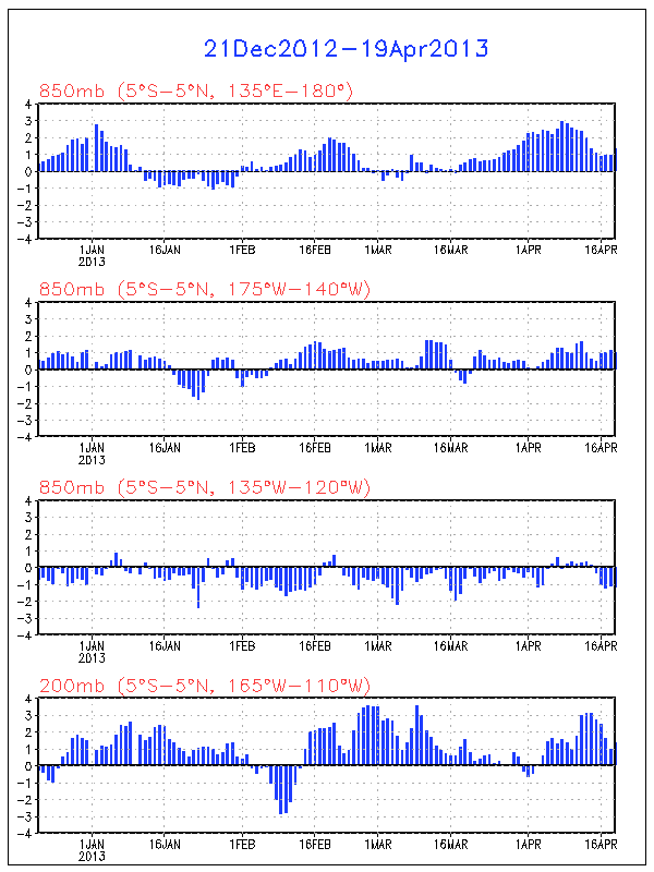
Here is a chart of the Nino 3.4 region temperature anomaly (which is the most consistent measure of ENSO conditions) versus the Trade Winds from 120W to 175W. The Trade Wind data is for 850 MB pressure or about 3,000 feet.

Click for a larger image
To see this correlation a little better, I’ve reversed the sign so that weaker Trade Winds are shown as positive values and stronger Trade Winds are shown as negative values. I’ve reduced the anomaly in meters per second by half as well so the scale is roughly the same as the ENSO.

Click for a larger image
I can’t imagine seeing a better explanation of what drives the ENSO than this.
For some perspective on the Nino regions and the latitude, longitude figures in question here, this is a map of the region produced by the Climate Prediction Centre.

I think you can see this impact in action if you watch an animation of the ENSO region over time. Let this SST anomaly animation load up, then speed it up as fast as your computer will allow and you can see the Nino region waters and temperature anomalies literally move across the Pacific with the Trades.
http://www.osdpd.noaa.gov/PSB/EPS/SST/anom_anim.html
But what drives these Trade Winds? I don’t really have an answer for that question.
The Southern Oscillation Index (SOI) was previously used as an indicator of these winds over the Nino regions. The SOI is a measure of the difference in air pressure between Tahiti and Darwin, Australia. The theory being that high pressure blows toward lower pressure which can provide some indication of the Trade Winds in the Nino region. There is certainly a correlation of this measure to the Nino 3.4 anomaly. In fact, the measure even lent its name to the ENSO.
I’ve found, however, the SOI consistently lags a little behind the Nino region temperatures and the Trade Wind measures so I believe it is more a result of the overall climate pattern rather than a leading indicator. I’ve also found no real correlation to the Pacific Decadal Oscillation or any of the other Oscillation Indices which are sometimes used to predict or measure the ENSO.
There is one leading indicator, however, which provides some predictive power – the Trade Winds just to the West of the Nino area. These Winds are, most often, concurrent with the Nino region Trade Winds but occasionally, they provide a ramp-up which might kickstart the ENSO. The West Trade Winds were a leading indicator of the Super El Ninos of 1982-83 and 1997-98 for example.

Click for a larger image
Unfortunately, I don’t know what drives these Western Trade Winds either, but they are currently pointing to a strengthening of the La Nina conditions which currently exist.
I also wanted to show more closely how the ENSO impacts global temperatures.
The warm or cold ocean conditions of the ENSO eventually impact the Tropics troposphere temperatures and this seems to be quite a direct impact with a lag of 2 to 3 months.

Click for a larger image
The Tropics temperatures then propagate out to the rest of the world with a small lag that may be up to 1 month but is more commonly concurrent with the Tropics anomalies.

Click for a larger image
The Trade Winds drive the ENSO, and the ENSO directly impacts the Tropics temperatures and the Global temperatures.
Who would have thought that Winds in some small region of the Globe could be so important. You can keep track of these Trade Winds on a daily basis at the Climate Prediction Centre.
http://www.cpc.ncep.noaa.gov/products/precip/CWlink/daily_ao_index/zw/zw.obs.gif
So, I think that provides a nice perspective on the ENSO.
The data used in this post can be obtained here.
http://www.cpc.ncep.noaa.gov/data/indices/
http://www.cpc.ncep.noaa.gov/data/indices/sstoi.indices
Ray (13:46:54) :
“Talking of wind… it seems that wind turbines can create heat islands miles down. Take a look at this http://www.sciencedaily.com/videos/2005/1012-wind_farms_impacting_weather.htm and the video.”
Known to only a few, this is why the tipped-nose Pelosi mouse range has moved further north to the Frisco Bay marshes from Palm Springs in only a few short years as a result of this global warming effect.
Off topic, but an thoroughly excellent article on “experts”, in this case financial. After a quick read, one can quickly place where the AGW crowd, like Gavin, and the AGW skeptics fit into the article.
http://money.cnn.com/2009/02/17/pf/experts_Tetlock.moneymag/index.htm?postversion=2009021816
A few select quotes:
“The models rested on a misplaced faith in the law of large numbers and on wildly miscalculated estimates of the likelihood of a national collapse in real estate. But mathematics has a certain mystique. People get intimidated by it, and no one challenged the models. ”
“My research certainly prepared me for widespread forecasting failures. We found that our experts’ predictions barely beat random guesses – the statistical equivalent of a dart-throwing chimp – and proved no better than predictions of reasonably well-read nonexperts. Ironically, the more famous the expert, the less accurate his or her predictions tended to be. ”
“Like all of us, experts go wrong when they try to fit simple models to complex situations. (“It’s the Great Depression all over again!”) They go wrong when they leap to judgment or are too slow to change their minds in the face of contrary evidence. ”
“You know the famous line that [philosopher] Isaiah Berlin borrowed from a Greek poet, “The fox knows many things, but the hedgehog knows one big thing”? The better forecasters were like Berlin’s foxes: self-critical, eclectic thinkers who were willing to update their beliefs when faced with contrary evidence, were doubtful of grand schemes and were rather modest about their predictive ability. The less successful forecasters were like hedgehogs: They tended to have one big, beautiful idea that they loved to stretch, sometimes to the breaking point. They tended to be articulate and very persuasive as to why their idea explained everything. The media often love hedgehogs. “
erlhapp (15:03:07) :
‘NO’ is too dismissive. I would go further. I would call it irresponsible.
Telling it as it is does not seem irresponsible. We have been down this road before. Your thesis seems to be that solar UV directly heats ozone in the upper troposphere and that raises the temperature there. The amount of ozone there and the amount of UV that survives down to there are so small that the direct heating is minuscule. Now, ozone is a powerful greenhouse gas and helps retain heat from below. None of this is controlled in any large measure by solar activity. The wavelength band of UV that reaches the upper troposphere even varies inversely with the solar cycle.
Is there not a hydro-mechanical element to it, and does that element not, in and of itself, serve as a feedback mechanism to the trade winds. The trades cause warm water to pile up in the Western “pocket” of the Pacific. At some point, that mass becomes gravitationally unstable. At some point where there is a minor “lull” at the synoptic scale, the mass surges eastward, as an additive “pulse” to the equatorial countercurrent (and at depth as well, under the main equatorial current). This wave of warm water reduces the east to west thermal gradient of the equatorial waters and thereby reduces that particular additive vector to the trades. The winds are reduced sufficiently that the movement of warm water westward is reduced. Etc.
Leif Svalgaard (15:33:27) :
The temperature data tells the story. 200hPa temperature peaks twice a year at 30°N and one of those peaks is in February when surface temperature is at its annual minimum.
Face the reality. Do the work. Look at the Hood presentation at http://www.atmosp.physics.utoronto.ca/SPARC/SPARC2008GA/Oral/day3_Hood.pdf
Notice the relationship between the solar cycle and ENSO with ozone dynamics in the upper troposphere in the mid to high latitudes where ozone accumulates.
At the moment you are saying that black is white.
“ozone is a powerful greenhouse gas and helps retain heat from below”
In the stratosphere yes. In the troposphere no. See:http://climatechange1.wordpress.com/2008/11/08/earth-laboratory-tests-the-greenhouse-theory-once-a-year-every-year-and-finds-it-wanting-every-time/
I’ll go with the evidence.
That is a fantastic series of plots, well done.
erlhapp (16:21:33) :
Look at the Hood presentation
They even say “Conclusion: The ozone solar cycle response coefficients calculated using a standard multiple regression statistical model do not change significantly when an ENSO term is added to the model”.
So, ENSO or not makes no difference for the solar cycle response, which is understandable as the work cited deals with the stratosphere 30-40 km up.
“ozone is a powerful greenhouse gas and helps retain heat from below” In the stratosphere yes. In the troposphere no.
from http://www.ghgonline.org/otherstropozone.htm
“Other Direct Greenhouse Gases – Tropospheric Ozone:
Tropospheric ozone can act both as a direct greenhouse gas and as an indirect controller of greenhouse gas lifetimes. As a direct greenhouse gas, it is thought to have caused around one third of all the direct greenhouse gas induced warming seen since the industrial revolution.”
Maybe you don’t believe that website, so here is better one:
From: http://www.temis.nl/products/o3tropo.html
“Ozone in the upper troposphere acts as a greenhouse gas by absorbing long-wave terrestrial radiation.”
Sreve Sadlov… pretty much… it’s called a kelvin wave, we’re in the tail end of one right now… that along with the end of the warm sst’s in the east (south of nino 1 + 2) are going to cause some nice cooling in the nino regions in the next few weeks. If that is joined by some cool sst’s from the north then this La Nina should stick around a bit longer.
Such a good thread. So maybe the real goodies will be found in studying this trade wind that flows East to West. If it is set up by temperature variations and rotation, anything we measure should be measured where this trade wind is. That means cloud cover, ozone blanketness (my word but it works), other trace gas blanketness, water vapor blanketness, etc, that occur in context with this trade wind. Maybe the focus should be right around the middle. Which is what I am trying to focus on since I am over a half century old. If I find out it is my Friday nights at the local tavern that is causing the bulge around the middle, I will swear up and down it is CO2. Wait…it actually could be too much CO2. Damn.
interview mit shaviv in haaretz.com
http://www.haaretz.com/hasen/spages/1063707.html
Leif Svalgaard (14:38:47) :
I agree on the millennial influence on cosmic rays. However, would not the near term fluctuation in Sun’s heliosphere also affect the Earth’s magnetosphere and in turn modulate the incoming cosmic rays?
See: Newell, P. T., T. Sotirelis, K. Liou, C.-I. Meng, and F. J. Rich (2007), A nearly universal solar wind-magnetosphere coupling function inferred from 10 magnetospheric state variables, J. Geophys. Res., 112, A01206, doi:10.1029/2006JA012015.
Note Brown’s short 3% correlation between cosmic rays & clouds over a few days:
Brian H. Brown, Short-term changes in global cloud cover and in cosmic radiation, Journal of Atmospheric and Solar-Terrestrial Physics Volume 70, Issue 7, May 2008, Pages 1122-1131
Is there evidence that there is no correlation between the solar wind and cosmic rays that could impact the cloud cover, insolation, sea temperature and consequently the trade winds? Or might such a connection be discoverable?
Leif Svalgaard
Apologies. I misread your meaning. I agree that the earth’s magnetic field varies on the millenial scale and thus is not an immediate cause of triggering trade wind variations. I was referring to the major influences modulating cosmic rays that I new of, not just limited to the immediate trade wind time scale.
David L. Hagen (19:26:53) :
However, would not the near term fluctuation in Sun’s heliosphere also affect the Earth’s magnetosphere and in turn modulate the incoming cosmic rays?
No, not through affecting the Earth’s magnetosphere.
The SOI continues in +ve territory. Yesterday the 30 day average hit a high for 2009.
http://www.longpaddock.qld.gov.au/SeasonalClimateOutlook/SouthernOscillationIndex/30DaySOIValues/
If SOI is a leading indicator then we should expect a stronger La Nina. NB La Ninas generally weaken in the northern spring/summer.
Leif Svalgaard
Could you please briefly explain what Newell et al. (2007) found and how it does/does not affect the impact of cosmic rays on low level clouds.
See: Newell, P. T., T. Sotirelis, K. Liou, C.-I. Meng, and F. J. Rich (2007), A nearly universal solar wind-magnetosphere coupling function inferred from 10 magnetospheric state variables, J. Geophys. Res., 112, A01206, doi:10.1029/2006JA012015.
Apparently I misunderstand the effects and/or terms.
Alan Chappell (07:07:07) :
As others have noted, this is false. Some researchers have been able to produce this effect in a lab-size sink, Science News had a note back in the early 1980s about it. IIRC, they were able to get the “proper” rotation 70-80% of the time, but had to work very hard to get the water still before opening the drain and had to worry about things like the symmetry of the drain (some are machined in a particular direction and that produces a bias).
Even at the size of tornadoes, some of them rotate in the “wrong” direction. Hurricanes are big enough to always spin in the right direction.
Let’s all use the right words for the same meaning.
Andre (22:47:47) wrote “Air moves from the tropics toward the equator to replace the hot air ascending over the latter.” By equator is meant the ITCZ (see below).
And crosspatch (02:20:13) wrote “Heated air rises above the tropics (again, ITCZ) and flows toward the higher latitudes (should be altitude), where it cools, sinks, and flows back toward the tropics (over the Tropics toward the ITCZ) in an easterly (east to west) (actually, NE to SW) surface pattern known as the trade winds. This constant, overturning flow in the tropics (troposphere) is called the Hadley circulation.
I think someone else had a similar comment also. Word usage and perhaps concepts seem to be getting a bit fuzzy. It is important to keep the regions and what is going on clear.
Usually, when speaking of these things we have polar latitudes, high latitudes, mid-latitudes, sub-tropical, tropical, and equatorial. Because the vertical sun travels back and forth across the Equatorial regions – mostly ocean – the air becomes warm and humid, and becomes buoyant. It will tend to rise. Clouds form (heat is released) and shadow. ItThe rising air is replaced by near-surface air flowing across the tropical latitudes, or Tropics. In the northern hemisphere these near surface winds appear to flow from the northeast, and because they were important in the age of sailing ships (think Columbus), they were called the Northeast Trades.
The SE Trades and the NE Trades usually meet, or almost meet, in the Equatorial area and thus the name Intertropical Convergence Zone (ITCZ). [One time when they did not meet has given us Coleridge’s The Rhyme of the Ancient Mariner.] The Trades feed into the Walker Circulation. In general, though, having risen to some height near the top of the troposphere (the tropopause) the air heads pole ward. The rotational effect (CORIOLIS force) gives this flow – high over the Tropics and the Trades – an eastward (right-hand) bias in the northern hemisphere. This high altitude air has lost its moisture and continues to loose heat (radiative cooling), becoming cold. Over the Subtropical areas it sinks toward the surface. The descent causes compressional warming (adiabatic descent) and the air nears the surface as a relatively warm dry air mass. The near-ocean surface air below it can be a few degrees cooler and a temperature inversion – almost no wind or clouds but hazy – frequently occurs. These areas are Sub-Tropical High Pressure (STHP) and provide the air that feeds the Trades and the air going north that feeds the Westerlies. Over land, winds that are part of the Hadley Cell still operate. In the Sahara they call this “trade wind” the Harmattan.
Not related to the above but: The western Pacific Ocean is topographically restricted (barrier like) while the Atlantic is not and the Atlantic, in the region of concern has the Amazon’s massive fresh water flow (over denser salt water) to add to the difference.
Leif Svalgaard (16:59:20) :
Let’s try and be relevant. What does Hood show?
1. The presentation links the production of the nitrogen compounds that degrade ozone to change in the AP geomagnetic index. “Strong correlation with Ap (and auroral & MEE power, and thermospheric NO) but not F10.7. Variability in SH stratospheric NOx from EPP controlled by variation in EPP-NOx production”
2. Temperature at 100hPa changes at 20°-30° latitude in both hemispheres with the change in solar radiation as represented by 10.7 Flux. This is linked to ozone content. The change across the ENSO cycle is stronger than the change across the solar cycle. La Nina frequently occur at solar Maximum and Solar Minimum.
3. Eddy Heat flux in the extratropical northern winter lower stratosphere, that drives planetary waves is shown to vary with ozone content. The flux peaks in January when sudden stratospheric warmings in the Arctic mainifest. This is the period of the year when stratospheric temperature in the northern hemsiphere varies most strongly. Temperature also varies elsewhere wherever there is abundant ozone such as at 20°-40°S. This is the time of the year when the tropical ocean warms most strongly. Its first and strongest peak is in April. It’s the time of the year where El Nino manifests. The 1997 event became obvious as a strong increase in ocean temperature off Chile in early March. The second peak is a midget by comparison and is associated with atmospheric heating and cloud loss associated with heating of the northern land masses and occurs in August.
4. The ozone ENSO coefficient is strongest in the East Pacific.
Re “Ozone as a greenhouse gas.”
Please take note.
1. There has been no increase in atmospheric temperature above 700hPa since 1948.
2. The increase in atmospheric temperature below 700hPa is associated with the release of latent heat. 850hPa temperature above the equator has increased by three times the rate of sea surface temperature in the tropics.
3. There has been a secular decline in atmospheric humidity and by inference cloud cover over the entire period since 1948.
The Earth has warmed because more sunlight gets to the surface to warm the sea. Only the skin of the atmosphere is in contact with the sea. So its only the first kilometer has actually warmed. The layers above the first km warm and cool with ENSO. So far, they have returned to base temperature after every heating episode.
The truth of the matter is that the troposphere very efficiently cools itself via convectional processes regardless of heat source and the mode and location of the warming activity. There is no greenhouse effect. None. Get over it.
The difference between the stratosphere and the troposphere is in the rate of convection. The stratosphere has cooled because of ozone loss due to moisture arising in tropical convection overshoot. That cooling process stopped about the turn of the century.
Now, an important question! Why does the tropical stratosphere cool as the Arctic stratosphere warms in a sudden stratospheric warming event of the sort that is just coming to a close? This is a very important question. Verify the facts for yourself at http://www.cpc.ncep.noaa.gov/products/stratosphere/strat-trop/
The answer to the question is vital to our understanding of the process by which ultraviolet light intensity at the tropopause and below varies independent of the suns output.
It would be nice if you actually conceded a point now and then rather than choose a point of attack and then push like blazes. It’s just good manners and common humanity.
Sir Anthony of the Watt:
A request please from this squire of your realm (Robt wonders if he is buttered up enough yet….) On a separate (but closely related) thread please address how much syrface and oceanic topography is actually included in the so-highly funded GCM that the world’s economies are now chained to.
Are ocean area represented – if so, how closely do their surface areas (their
finite element cubes) match the real world along the Pcific and Atlantic shores.
Do the GCM’s actually model (or predict) or even “notice” ENSO and PDO cycles? If not, why not.
Once a GCM has cycled for several hundred “years” (and do they model the “solar year” with it’s changing radiation and incidences, or only the “average” entire year ?) do any of them begin to create oscillations similar to ENSO’s?
Do GCM’s “create” cold fronts and the arctic air flows when they run, or are they “static” heat exchange models only (radiation received and radiation released are obviously their “drivers” … But what happens after the air masses have been “driven” for the equal of one or two “years” – do we see flows in the tropics, mid-latitudes, and polar latitudes than resembles earth’s circulation? Or do the final patterns more closely resemble the moon’s weather? 8<)
I have run, edited, definied, critiqued, created, and used the results from nuclear (neutron flux) 3D finite element models, stress-strain mechanical design models, heat flow finite elements, machining FEM’s, fluid flow 3d models, and even concrete and molded metal models. How large are the GCM “grids (boxes) and what “information” is “shared” through each element face as the simulation progresses?
How are GCM “boxes” divided vertically through the atmosphere? How do they account for mountains and large permanent influences like deserts, huge areas of grasslands (central US, central Russia, India, France, etc) compared to mixed regions like the Med, Great Lakes, and CA and smaller pennisulas or desert areas?
If the “boxes” are so large that every land area is considered equal – how are coastal regions and ice-covered areas modelled as they change over the year?
REPLY: Thank you, but I’m not an encylopedia for hire, perhaps readers can help with questions. – Anthony
On the dangers of specialization and the need for a well rounded education and keeping an open mind:
The discovery of the relationship between muon counts and sudden stratospheric warming in the Arctic began with a conversation between two specialists that is described in this way:
Osprey says the project shows the value of collaboration between different scientific disciplines. ‘These environmental effects have been well documented by physicists interested in cosmic rays,’ he says. ‘But there hasn’t been the cross-pollination with the atmospheric science community, because people haven’t been speaking to each other. If they had, we could have known about this connection 50 years ago.’
http://planetearth.nerc.ac.uk/news/story.aspx?id=300
It seems to me that there are people making pronouncements about climate that are ignorant of the basics, not interested enough to examine the historical data and quite unfamiliar with the geographical factors that are responsible for the differences that manifest between the hemispheres let alone across the span of latitudes with all the diversity that arises therefrom, and also due to the rapid change of state between the surface and the outer limits of the atmosphere.
Frequently I read some pronouncement about climate and I cringe. The word that gives rise to instant dismay and teeth grinding aggravation is, ‘greenhouse’.
Nevertheless, I commend all triers. Taking an interest is the best way forward.
The people who are arguing about oscillations that are totally within the Earth’s atmospheric/ocean system must realize that their debate is
ultimately pointless if the factors which control the long term changes
in the trade winds are externally driven.
I beleive that the following two graphs clearly show that changes in the PDO are driven externally by an as yet unknown process that is synchronised with the solar motion about the Solar Systems centre of mass. {note: I am not saying that the solar motion is causing the process, nor am I claimng to lnow
what this process is.]
http://f1.grp.yahoofs.com/v1/oC2dST9xJv9nbcZK4Og69pNMoPPG484WXOoWxYpaf-Q8d5BSUmpD6bHsnFVyTKnI-XmwMW0P40uyJEIPd0aw3Q/PDO_ROT.JPG
http://f1.grp.yahoofs.com/v1/oC2dSYSsAkxnbcZKvtKWaDBd-ktW0ZD8IXAIa9u5WwfBsttzY3QtPVNy3OCAw28wK2uTAjNvsccuZ-86VG8NyQ/Solar_rot.JPG
If you cannot see these graphs please let me know.
And I believe that the following graph shows that it is the PDO that reinforces the ENSO and not the other way around. This third graph clearly shows that
whenver the PDO is positive, the level of intensity of El Ninos get strong and strong, and whenever the PDO is negative, the intensity of the El Ninos gets weaker and weaker. Logic tells you that it the phase of the PDO (which seems to flip from a postive to a negative state] that is influencing the intensity
level of of the El Nino phenomenon.
http://f1.grp.yahoofs.com/v1/oC2dSbCyqOVnbcZKTWnhnZ-WlllYcH_NW8R6iolAo0Vu2EgQJCPL2munw3KTVhEB9KAX2_YykoYk_okI5ZfEaw/ENSO_PDO_COMP.JPG
Could someone one please explain why the PDO climate system seems to be
synchronized with the motion of the Sun about the centre of mass of the solar system?
Dismssing this data out-of-hand with trite arguments about how you don’t like what it implies will not hold water in the long run.
Bill and all oceanographers:
I revisited a paper by Hathaway et al which compares solar activity, geomagnetic activity and the Armagh temperature record, which runs from 1840 in a non-uhi-contaminated location 65m above sea level near the coast of Ireland.
http://solarscience.msfc.nasa.gov/papers/wilsorm/WilsonHathaway2006c.pdf
At the top of page 8, there is a graph which shows the residual left after taking the sunspot numbers smoothed over the hale cycle from the temperature data smoothed over the hale cycle.
Hathaway et al conclude with the usual “it could be AGW” statement at the end, but something caught my eye. If you were to subtract the AMO from the residual, you would end up with something pretty close to an anti-correlation.
http://images.intellicast.com/App_Images/Article/129_0.png
I realise the AMO will also have been affected by solar input, but given the AMO varies by 2C or so in the longer term, and the residual calculated by Hathaway et al is only 0.5C or so from peak to trough, it would seem that after allowing for the solar effect on the AMO there wouldn’t be much room for any co2 warming effect in the Armagh temperature record after the calcs were done.
Would it be worth someone like yourselves grabbing the data and doing a pro job on this?
Robert A Cook PE: I can try to answer part of your questions or at least provide you with links that can. The models used for IPCC projections do NOT model ENSO correctly, if they model it at all. This was confirmed by Kevin Trenberth a few years ago in a post at the Nature blog:
http://blogs.nature.com/climatefeedback/2007/06/predictions_of_climate.html
He wrote, “None of the models used by IPCC are initialized to the observed state and none of the climate states in the models correspond even remotely to the current observed climate. In particular, the state of the oceans, sea ice, and soil moisture has no relationship to the observed state at any recent time in any of the IPCC models. There is neither an El Niño sequence nor any Pacific Decadal Oscillation that replicates the recent past; yet these are critical modes of variability that affect Pacific rim countries and beyond.”
There are coupled GCMs that do attempt to model ENSO, with mixed results. Refer to:
“The El Niño Southern Oscillation response in the BMRC Coupled GCM”
http://www.bom.gov.au/bmrc/pubs/researchreports/RR91.pdf
And to:
“ENSO dynamics in current climate models: an investigation using nonlinear dimensionality reduction”
http://www.nonlin-processes-geophys.net/15/339/2008/npg-15-339-2008.pdf
And to:
http://www-pcmdi.llnl.gov/wgne2007/presentations/WGNE-Workshop/Manganello_WGNE.pdf
Eric Guilyardi has a number of papers here about CGCMs and their problems (and advences) with modeling ENSO here:
http://www.met.rdg.ac.uk/~ericg/publications.html
There are many more critiques (refer to references in the above papers) available through Google. I hope that helps.
Regards
I have noted lately that whenever someone dares to suggest a solar influence on any aspect of the earth’s atmosphere they will have to cross swords with Leif. Wouldn’t it be great if Leif in his great wisdom and academic brilliance could help us in finding a cause for the multi-decadal climate fluctuations we have been observing, in the same vein as his colleagues Svensmark, Shaviv, Friis-Christensen or Veizer are trying to do? Or is he a disguised AGW proponent trying to frustrate the skeptic community?
erlhapp (21:57:19) :
Let’s try and be relevant.
That would be refreshing. What Hood’s presentation is about is ozone in the stratosphere.
Greenhouse gases are very important, especially water vapor. Without GHCs the Earth would be too cold to live on [255K].
I say again [cutting through the mass of obscuring irrelevant detail] that as far as I can see your thesis [mechanism, whatever you like to call it] is that the solar influence is due to direct solar heating by UV of ozone in the upper troposphere and that that extra heat drives ENSO. True or false? One line will suffice for an answer.