Guest post by Bill Illis
We have often wondered what really causes the El Nino Southern Oscillation (ENSO) climate pattern. It is generally understood and this post will demonstrate that it is really driven by the Trade Winds over the ENSO region.
The Trade Winds blow East to West at the equator. Most of us living in other latitudes expect the wind and the weather to primarily come from the West but, at the equator, the weather comes from the East.
When the Trade Winds are stronger than average for a sustained period of time, the Trades literally blow or drag the warm surface water across the Pacific and it is replaced by colder upwelling ocean water from below. If the Trades are strong enough for a long enough period of time, we have a La Nina.
When the Trades are weaker than average for a long enough period of time, the ocean surface stalls in place and gets heated day after day by the equatorial Sun and we have an El Nino. Sometimes, this stalling even results in warmer ocean water from the Western Pacific moving backwards into the Nino region and this also contributes to El Nino conditions.
Let’s look at the data to see how true this assertion is.
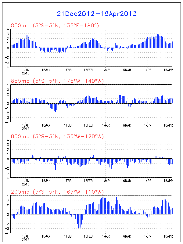
Here is a chart of the Nino 3.4 region temperature anomaly (which is the most consistent measure of ENSO conditions) versus the Trade Winds from 120W to 175W. The Trade Wind data is for 850 MB pressure or about 3,000 feet.

Click for a larger image
To see this correlation a little better, I’ve reversed the sign so that weaker Trade Winds are shown as positive values and stronger Trade Winds are shown as negative values. I’ve reduced the anomaly in meters per second by half as well so the scale is roughly the same as the ENSO.

Click for a larger image
I can’t imagine seeing a better explanation of what drives the ENSO than this.
For some perspective on the Nino regions and the latitude, longitude figures in question here, this is a map of the region produced by the Climate Prediction Centre.

I think you can see this impact in action if you watch an animation of the ENSO region over time. Let this SST anomaly animation load up, then speed it up as fast as your computer will allow and you can see the Nino region waters and temperature anomalies literally move across the Pacific with the Trades.
http://www.osdpd.noaa.gov/PSB/EPS/SST/anom_anim.html
But what drives these Trade Winds? I don’t really have an answer for that question.
The Southern Oscillation Index (SOI) was previously used as an indicator of these winds over the Nino regions. The SOI is a measure of the difference in air pressure between Tahiti and Darwin, Australia. The theory being that high pressure blows toward lower pressure which can provide some indication of the Trade Winds in the Nino region. There is certainly a correlation of this measure to the Nino 3.4 anomaly. In fact, the measure even lent its name to the ENSO.
I’ve found, however, the SOI consistently lags a little behind the Nino region temperatures and the Trade Wind measures so I believe it is more a result of the overall climate pattern rather than a leading indicator. I’ve also found no real correlation to the Pacific Decadal Oscillation or any of the other Oscillation Indices which are sometimes used to predict or measure the ENSO.
There is one leading indicator, however, which provides some predictive power – the Trade Winds just to the West of the Nino area. These Winds are, most often, concurrent with the Nino region Trade Winds but occasionally, they provide a ramp-up which might kickstart the ENSO. The West Trade Winds were a leading indicator of the Super El Ninos of 1982-83 and 1997-98 for example.

Click for a larger image
Unfortunately, I don’t know what drives these Western Trade Winds either, but they are currently pointing to a strengthening of the La Nina conditions which currently exist.
I also wanted to show more closely how the ENSO impacts global temperatures.
The warm or cold ocean conditions of the ENSO eventually impact the Tropics troposphere temperatures and this seems to be quite a direct impact with a lag of 2 to 3 months.

Click for a larger image
The Tropics temperatures then propagate out to the rest of the world with a small lag that may be up to 1 month but is more commonly concurrent with the Tropics anomalies.

Click for a larger image
The Trade Winds drive the ENSO, and the ENSO directly impacts the Tropics temperatures and the Global temperatures.
Who would have thought that Winds in some small region of the Globe could be so important. You can keep track of these Trade Winds on a daily basis at the Climate Prediction Centre.
http://www.cpc.ncep.noaa.gov/products/precip/CWlink/daily_ao_index/zw/zw.obs.gif
So, I think that provides a nice perspective on the ENSO.
The data used in this post can be obtained here.
http://www.cpc.ncep.noaa.gov/data/indices/
http://www.cpc.ncep.noaa.gov/data/indices/sstoi.indices
And…do not forget taking into account that the people who named El Nino as such (the descendants of the Moche Culture people) blame the Sun for this phenomena CLICK
REPLY: Just type in the URL with the comment, don’t bother with tags – Anthony
And…do not forget taking into account that the people who named El Nino as such (the descendants of the Moche Culture people) blamed the Sun for this phenomena see http://www.giurfa.com/theangrysun.jpg
Sorry, here is the link:CLICK
“When the Trade Winds are stronger than average for a sustained period of time, the Trades literally blow or drag the warm surface water across the Pacific and it is replaced by colder upwelling ocean water from below. If the Trades are strong enough for a long enough period of time, we have a La Nina.”
Biil, assume that you are right that the Trade Winds drive the ENSO, what then causes the trade winds to be stronger than average?
The CFS ensemble mean forecasts of Nino conditions are not very accurate. While they should be taken into account, the accuracy is pretty low.
The prediction (including the November forecasts) leading into this Nino season was for neutral conditions. A few weeks later and there is a La Nina.
The prediction as late as February 2007 was for just a 1% chance of a La Nina developing in 2007 and by the time the forecast had been published, the La Nina trend had already started.
I’ve been following the ENSO since I was very young when the 1982-83 super El Nino started to make the news. I haven’t noticed good predictive capability in the forecasts ahead of the events.
You can review the archive of the Nina predictions here.
http://www.cpc.ncep.noaa.gov/products/expert_assessment/ENSO_DD_archive.shtml
It is generally understood and this post will demonstrate that it is really driven by the Trade Winds over the ENSO region
Winds are a response to pressure differentials and I would think pressure differentials are ultimately caused by heat. So mabye this is mixing cause and effect?
Hm. The Hypothesis of Marcel Leroux starts with what drives the trade winds. He registered ‘pulses’ in the trade winds and postulates that they are driven by Mobile Polar Highs (MPH) when they end up near the equator.
His book ‘Global Warming – Myth or Reality’ (ISBN-13: 978-3540239093) is a fascinating read. Try http://www.amazon.de/Global-Warming-Climatology-Springer-Environmental/dp/354023909X/ref=sr_1_1?ie=UTF8&s=books-intl-de&qid=1234969104&sr=8-1
So it appears that trade wind speed decides if we have more El Nino’s (a quiet warm pond) or more La Nina’s (an agitated, thus colder pond). CO2, if it had any affect on trade wind speed should lead to the East to West trade wind speed slowing down, thus setting up the Pacific oscillation to its warm El Nino conditions as the predominant condition. So here is the test. Are the trade winds slowing as CO2 increases? What are its windspeeds right now? What has been the correlation in the past between trade wind speed and atmospheric CO2?
Don’t overlook tallbloke’s comments above.
We know LOD varies continually, partly a function of seasonal distribution of ice mass and partly a function of variable magnetic coupling betwixt sun and earth.
We know that as the rotational rate derivative changes, angular momentum is transferred between solid and fluid (atmosphere and ocean). (GLAAM is a poor measure of this.)
From a consideration of physics alone, this must be A (probably THE) major driver of changes in the trades. But not the only driver, as Tisdale points out; this is a complex, chaotic system….a chaotic system that is easily modeled, of course, which is why our weather forecasts are so bloomin’ accurate.
Andre Tahon (22.47.47)
Something else to ponder on;
in the Northern hemisphere water, when in a bath, will, when the plug is pulled will turn in an anticlockwise direction. In the Southern hemisphere it goes down the hole in a clockwise direction, I think Sir, all is not as simple as it seems, as gravity has a very important part to play in our weather systems.
REPLY: It manifests itself in something known as the Coriolis force – Anthony
Very informative on a mind-boggling subject. Nice job.
As i have pointed out before, every El NINO since 1980 has shown an anomalous cool pool at 150m depth in the 160e to 180e area. That cool pool has grown and spread east, over time, during the El NINO. During every La NINA since 1980, the exact opposite condition exists. The developement of El Ninos/La Ninas can be observed here http://www.bom.gov.au/bmrc/ocean/results/pastanal.htm. Since we are in a classic La NINA configuration, which takes several months to subside, and then several months for an El NINO to develope, it is very unlikelt that we will see an El NINO before August. The Indonesia area, where the Pacific Warm Pool exists, is also a very active geothermal area, which is not well accounted for in ENSO analysis.
What you have here, is a complex system consisting of oscillators, inside oscillators inside oscillators. Each oscillator moving at its own natural resonate frequency, sometimes helping or hindering the larger oscillator it is part of and sometimes being aided or retarded by a junior oscillator which is a part of it.
For a thought experiment, lets suppose we could let the earth stabilize to an absolutely isothermal condition, then “turn on” the weather, sun etc. to let the drivers begin to drive the system. At some place somewhere on the plains of some continent, the local heating on one slope of a gentle valley would be more strongly heated by the sun than the opposite slope. The warmed air above the more favorably heated slope would start to move up slope due to heating, and the cooler air on the other side of the valley would start to sink. You now have a small convection cell, which would quietly circulate until it gets strong enough to lift the warm air column above condensation level and start to condense a cloud out. Since the sun is almost never directly over head the shadow of the cloud would cool another piece of ground(not under the main updraft) that used to be heated by the sun. That air would sink and then get pulled under the rising column of convection, adding more energy. Eventually you get a thunder storm which, develops a strong updraft and pulls in warm moist air to feed the storm. Then it suddenly dumps rain, cooling the ground below it and producing a strong cool down draft. That produces a cold outflow boundary which sweeps across 100 miles of terrain as it mixes with local air and warms back up. This kick starts other convection cells into full fledged thunder storms and the cycle continues for ever.
Each small perturbation in that isothermal earth would do the same thing. Over time some of those local systems join to feed each other or inhibit each other and then you have large scale circulations.
In short you have a chaotic system with uncountable numbers of inputs all trying to equalize some small imbalance of forces/effects (temperature, density, humidity, radiant heat loss, radiant heat gain). Some of these actions amplify near by motions others inhibit near by motions. Some build into large scale regional circulations, which in turn build into global scale circulations.
Likewise on a global scale you have stronger heating near the equator than higher latitudes due to the curvature of the earth and the angle of incidence of the suns rays causing differential heating from the equator to the poles. Then you have different albedo of surfaces (sometimes albedo that changes by time of day due to terrain slope and sun angle).
I think we can reasonably expect to identify the more dominant factors, but to think we can trace that chain of instabilities and oscillations down to their source is naive in my view. Due to clouds, differences in humidity, winds and lifting due to terrain, axial tilt, rotation of the earth, orbit around the sun, the conditions are never uniform and always trying to equalize something.
Bottom line you have the butterfly effect in action. Everything is triggered by everything else in some measure, and everything drives something else, like a mobius strip, you cannot find the end, as one driven element always will lead to another driver, which in turn is driven by yet another driver.
Stability in an electronic circuit is determined by the degree of feed back and its phase to the input, change the phase shift or the strength of the feed back or modify dampening (resistance) and the characteristic frequency of oscillation will change. If you get the feed backs small enough or negative you have a stable circuit, but even a stable circuit will ring if you hit it hard enough. It just will not ring very long.
The tradewinds, sea surface temperature, and build up of pools of warm water are all elements of the same oscillator. You change any of them, and you change all of them. At some level of input they reinforce each other, but eventually that hump of hot water in the west gets big enough that it over powers the trade winds and tries to slosh back to the east. That changes the driving forces for the winds since thermal uplift is now occurring in a different place, so the whole system reorganizes. When you shift from El Nino to La Nina you didn’t change just one thing you have a whole new system.
At least that is how I see it, coming from the perspective of a severe storm chaser. We would see this chaos play out day after day. All the atmospheric conditions were favorable for explosive thunderstorm development and nothing would happen because too many thunder cells tried to form at the same time each stealing energy from its neighbor. On other days with lower theoretical potential, you would have one cell that got just a tiny head start on its neighbors and it would grow to a monster super cell and create its own local weather environment and literally “eat” other smaller storms.
Weather is fascinating, but I suspect will never be predictable in the common sense use of the word. I fear the best we can do is establish trends and probable outcomes.
Larry
Bill Illis: I’ve been looking (with no success) for data on the flow rates and reversals of the Pacific Equatorial Undercurrent and the Pacific Equatorial Intermediate Current. It would be nice to see the time-series data of those, too. I’ll keep looking, but I have a funny feeling there’s nothing available.
It sounds like we are just beginning to understand our climate and it’s mechanisms.
Regardless, what in the (blank) are we waiting for?
We must extract Americas oil NOW. The revenue and savings generated from home grown American energy will STIMULATE our economy. We are facing an economic crisis. Is there a [better] time to tap our own reserves? This will help buy us time to recover economically and help pay for alternative energy.
Drill here, drill now!
The prophet Al Gore and his blind sheep are only fueling the problem. This is simply more proof that extremists, sometimes unknowingly, erode the pillars of national security.
Wake up America. The planet is not anthropologically unstable. Some of the people are.
The complexity of ENSO is the reason that the worlds best minds and computers demonstrate little skill in ENSO forcasts. The trades are major contributors but there are additional contributions by SST’s in different locations and even the Antarctic Circumpolar Current. Not only will these factors play a role in the onset and duration of ENSO events, but their magnitude as well. Then there are subsurface temperatures associated with kelvin waves which also play a major role in ENSO.
The contribution of PDO is rather easy. The weather patterns that accompany different PDO phases will modulate the temperature of the SST’s being blown into the Equatorial Pacific. For instance, during a cool PDO phase, cool upwelling off the North American coast will be blown into the Nino 3 region which in turn prevents the warm tongue from propagating much farther than 140 or 160w. This holds the atmosphere along the equator in a neutral or La Nina pattern. If there is no contribution of cool SST’s to that area, then the warm tongue will move farther east and change the vertical structure of the atmosphere creating a greater liklihood of El Nino.
One important aspect which might help those looking for the driver of the Trade Winds is that there is a strong seasonal component to the ENSO.
About 80% of El Ninos and La Ninas start developing in the late spring and early summer. They peak around November to January.
The current La Nina is one of non-traditional 20% which do not follow this timeline although the peak could have been in January so it might fit as well.
So, it appears there is a driver related to the northern hemisphere summer which peaks and declines as the winter solstice hits.
The sun is directly overhead of the Tropic of Cancer as the trend starts, the sun then moves over the equator as the trend is accelerating the most and then the Sun is overhead of the Tropic of Capricorn as the Nino peaks and declines.
Something to think about anyway.
Pamela Gray asked about the current strength of the Trades. The Trades over the ENSO region are a little above average right now but the leading Trade Winds to the West are at their highest level in the record since 1979. This should lead to strengthening La Nina conditions if the correlation follows the previous trends.
There is a good explanation of the coriolis effect, with animation, at http://en.wikipedia.org/wiki/Coriolis_effect .
Bob Tisdale, re the data on the currents… I’d expect that data to be available at TAO… if not then try SCRIPPS, they’ve published a few studies on them… I usually just look at the thermocline slope since it’s going to give you the same general information in different terms and is probably a bit more relevant.
Bill: Is it possible that a reduction in geothermal heat, in the area around Indonesia, leads to a reduction in the supply of warm air lifting. This could lead to a reduction in East to West trade winds. As a consequence, the warm pool, along with the now anomalous cool pool, migrate East. Upwelling of cold deep water continues to feed the cool pool, which grows, frequently reaching the West coast of S. America. Food for thought.
Hmmmm…
“SST anomaly animation ” http://www.osdpd.noaa.gov/PSB/EPS/SST/anom_anim.html
What I find interesting is the Cooling of the North Atlantic in January and February
Alan Chappell (07:07:07) :
Andre Tahon (22.47.47)
Something else to ponder on;
in the Northern hemisphere water, when in a bath, will, when the plug is pulled will turn in an anticlockwise direction. In the Southern hemisphere it goes down the hole in a clockwise direction, I think Sir, all is not as simple as it seems, as gravity has a very important part to play in our weather systems.
REPLY: It manifests itself in something known as the Coriolis force – Anthony
The Coriolis Force is due to rotation not gravity.
“what then causes the trade winds to be stronger than average?”
In the industrial production of ozone the air is dried by chilling it to minus 80°C because ozone is very soluble in water.
On the west of all the major continents where the air is driest at about 30° of latitude high pressure cells tend to linger that bring ozone rich air downward into the upper troposphere. When the intensity of ultraviolet light from the sun increases, temperature rises in this ozone rich air and weakens the downdraft, lowers the surface pressure and with it the strength of the trade winds that blow across the ocean to the low pressure zones that form over the warm waters that accumulate in the west.
In short, its the sun.
More at http://climatechange1.wordpress.com/2009/01/02/the-southern-oscillation-and-the-sun-2/
It appears that the upper 300 metres of the eastern Pacific, the coldest part, is currently warming. See http://www.ecmwf.int/products/forecasts/d/charts/ocean/real_time/xzmaps/
When the upper troposphere warms, the ice cloud (cirrus) tends to disappear. That accounts for the surface warming that relates strongly to the temperature of the upper troposphere, the change in surface pressure in the high pressure cells at 30° of latitude and the strength of the easterlies that Bill has so neatly identified and described.
Bill, I like the choice of the 850hPa pressure level. Nothing ambiguous about that.
The climate shift of 1978 involved a massive increase in upper troposphere temperature at 30° latitude where ozone content is highest. Between 100hPa and 200hPa the trend since that date has been for temperature to decline.
The run of strong El Ninos that we have had since 1978 has diminished the level of humidity in the troposphere and with it cloud cover. It has increase the humidity of the stratosphere reducing its ozone content resulting in cooling. But since 2000 the stratosphere is starting to warm again as ozone recovers.
Looks to me like El Ninos occur about every four years and the intensity rises and falls over the 100 year solar cycle period.
It’s not the Coriolis but the lack of Coriolis at the equator. The lack of spin associated with vertical movement of air and water is a major contributor as to why there is ENSO in the first place. There is something of a separate weather and sst zone within about 5 to 10 degrees of the equator in each direction.
srchuck (07:05:41) :
We know LOD varies continually, […] and partly a function of variable magnetic coupling betwixt sun and earth.
No, that has not been demonstrated. I’m sure you can find many claims of that, but that does not make it so.