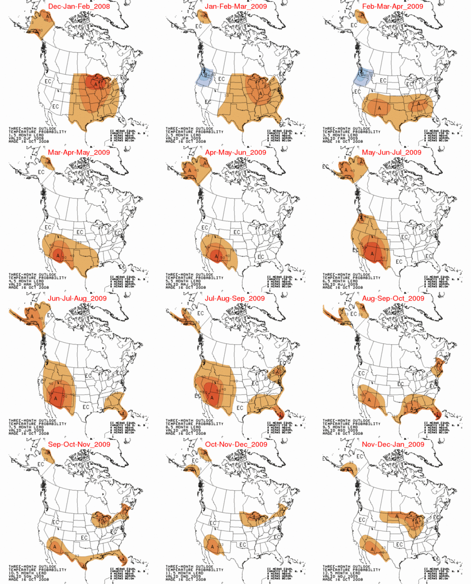
We are almost at the half way point for the meteorological winter (December through February) and it is a good time to evaluate how the NOAA CPC (Climate Prediction Center) and UK Met Office winter forecasts are doing so far. As seen below, CPC forecast the highest probability of warmth for Alaska and the upper midwest.

Trend of mild winters continues
25 September 2008
The Met Office forecast for the coming winter suggests it is, once again, likely to be milder than average.
Their scorecard is doing equally well, with the UK having it’s coldest winter in decades, as reported by the BBC.
last month proved to be the coldest December in more than 30 years, with the average temperature at 1.7C (35F), compared with the long-term average of 4.7C (40F) for the first part of the month.
On December 12, they issued this press release:
The Met Office seasonal forecast predicted the cold start to the winter season with milder conditions expected during January
Yet the Met Office appeared undaunted by yet another incorrect seasonal forecast, as reported by the always faithful Guardian earlier this week.
In the midst of a cold snap – a hot weather warning
As temperatures stay stubbornly well below freezing, it may feel like the last issue on anyone’s mind, but the government has been warned it may need to start thinking about introducing emergency hot weather payments to help poorer households keep cool.
The cold spell caused significant problems in many areas of the country. The Government’s bill for Cold Weather Payments is expected to rise to more than £100 million
How we did
The Met Office correctly forecast the spell of cold weather and kept the public informed via our various forecasts.
ML original site here:
http://www.esrl.noaa.gov/gmd/ccgg/trends/
Les Johnson:
I don’t think the dice example is a very good analogy for long term climate prediciton – far too simple and stable.
I would imagine the climate system is more like 3 dozen irregular objects, each with multiple faces; some faces change their values from throw to throw in random patterns and others change from throw to throw in a more predictable pattern. Most can provide fairly broad ranges of values both negative and positive.
You can know the approximate values contributed in each throw by 12 of the objects + or – 10%, you can only be given a broad range of probable values contributed by the next 12, and you know nothing about the contribution of the final 12.
You are given the total value of each of the previous 30 throws and you know that the total value fluctuates a lot within a certain range and statistically has increased by about 0.13 per each 10 throws. You are not told whether or not the trend is just statistical noise.
Assume you will throw them all 200 times. Now predict for us the trend of the total value over the next 200 throws. What is your prediction for the average of your first 100 throws? The last 100 throws? What is your prediction for the average of the last 10 throws?
I would imagine that the above game would actually be easier than predicting Earth’s climate over the next 200 years.
John Finn (14:02:03) :
But is it a cold winter?
E.M.Smith (15:04:13) :
Yes.
Any data to support this? (not newspaper reports).
Note that both satellite records (RSS & UAH) for December are ~0.2 deg above normal globally and ~0.4 deg above normal in the NH.
Re the weather vs climate distinction, I can’t see it is valid to claim that CO2 climate forcing is compatible with anything other than a steady observable increase in the planet’s heat content year on year.
So if the surface temperature is not showing this trend then that can only be explained away by uneven distribution patterns and believers in AGW have to show where it is being stored. The evidence is that it is not being stored in the oceans (Pielke snr’s Climate Science, 6 Jan 08).
Re UK Met Office claim that December coldest for 30 years.
I’ve been reading this blog for a while and found it a fount of knowledge, amazing common sense and great scientific debate and entertainment. Hope I can chip in with a little reference to an article on the ‘media’ claim for the ‘coldest December for 30 years in the UK’ that injects a bit of perspective.
Philip Eden meteorologist for Daily Telegraph (no sign of his article in online Telegraph – Weather statistics offer cold comfort) says basically this claim is due to ‘media’ ignorance and press offices trying to provide the media with attention-grabbing hype (I assume the press office in this case is the Met Office).
Eden said: ‘What the press release did not make clear was that the ‘coldest since 1976′ line referred to the period Dec 1-10…’ [presumably the *start* to December that Chris referred to] and he said any other selection of dates would not be particularly newsworthy.
Eden says Dec 1-8 coldest only since 1998; Dec 1-12 coldest since 1991; and claims monthly figures show December coldest for just 7 years not 30.
He then says a little about ‘cherry-picking’ statistics…
Les Johnson: “Lets say I throw a die. It has about a 17% chance of any particular number coming up. That’s weather.
Lets say I track this for 1000 throws. I can predict how many times a given number will come up, with pretty good accuracy. That’s climate.”
Sorry Les, apparently you are not much of a gambler. Each throw of the die is totally independent of all previous throws and has no relationship to them. Of course, using algorean science and by hansenizing the data you may be able to make people think you can predict with a degree of accuracy.
I’m going to make this my tagline on future emails:
“All forecasts should be written in pencil”
TWEEEEEEEET!!
Piling On! 10 yard penalty!
1. I didn’t say that climate could be predicted with any accuracy. Or weather. But climate should have better longer term predictablity.
2. I was using an analogy, to show how a series of chaotic events could be predicted better than the individual events. Note that I said that climate is “hellishly complex” to predict.
3. Tom : I am a very good gambler. If we throw the dice 1000 times, I predict that a 6 will come up 167 times, plus or minus 10. Did you want to bet me on this?
If you were thinking that I could predict an individual event; well, that would be just silly, now, wouldn’t it?
FYI, unpredictable weather and unreliable forecasts are largely a NH phenomena.
Most of you would be amazed at how accurate short term (up to a week) weather forecasts are in the SH.
Although, that doesn’t make our seasonal outlook forecasts (3 months) any more accurate, as Warwick Hughes has documented. Nor are (global warming biased) long term predictions any better.
My point being that forecasting short term weather and longer term climate are different things and success or failure in one tells us nothing about success or failure in forecasting the other.
The dice analogy is actually quite a good one.
We can infer from the UK Met Office that they have their heads up their ars*s.
The seas around even the South coast of the UK are freezing, albeit in sheltered areas at present, but this hasn’t happened since the windter of ’62-63. I’d say that is 46 years.
Just an anomolly; nothing to see here; move on. Besides, we predicted this warm spell.
It’s been so uncharacteristically wet here in Tennessee. Seems like I haven’t seen the sunshine in forever.
Jordan.
http://www.theriverjordan.net
John Finn, You are assuming that you know what “normal” is. That’s the kind of misleading misuse of words that we all complain about. The anomaly is against a chosen baseline. Who knows if that’s normal or not! IMHO it’s wrong to characterize any arbitrary choice of time frame with connotative words until a better understanding of the climate exists.
Cool Tim in Florida hansenizing the data I think this phrase will go down in imfamy 🙂
From my boss when a customer realizes the product doesn’t meet spec: “Hey, did you Hansenize the data?”.
Disclaimer: I am not now, nor ever have been, a Hansenizer.
crosspatch (10:52:53) :
” “but can anyone tell me how you generate high pressure over the dark arctic in winter? ”
Air aloft radiates its heat into space and cools. As it cools, it sinks generating an area of high pressure.”
My question, then, is why does the high pressure area happen this year, for such a prolonged period, but not every year? Surely the air above the arctic radiates its heat into space each year?
I am very familiar with black body radiation.
Roger E. Sowell
Marina del Rey, California
The Moana Loa Observatory CO2 reported for December 2008 (384.11) just happens to be identical to the value reported for November 2008. I expect them to revise the value shortly.
Tom in cooler than I like Florida (16:55:19) :
‘Sorry Les, apparently you are not much of a gambler. Each throw of the die is totally independent………’
Not unless the die are loaded. (hocky stick)
“Ellie in Belfast (16:22:12) :
Noting the UK Met Office forward projections.
News release 19th Aug 2007
“1998 is the current warmest year on record with a global mean temperature of 14.54 °C”
30 December 2008 Press release
“The warmest year on record is 1998, which was 14.52 °C, a year dominated by an extreme El Niño.”
1998 downgraded by 0.02°C in 18 months?”
Ellie,
How else can we make all these cold years warmer than 1998?
It’s just an adjustment. No one has been upset about the last three or four hundred thousand adjustments. Why should that one matter? Please pay no attention to the adjustments. We are doing it for the children.
Mike Bryant
Roger E. Sowell
Areas of persistent high pressure vary from one year to the next in intensity and location. For example, the summer hurricane season is greatly dependent on the intensity and location of a persistent high pressure zone off the coast of North America called the Bermuda High. If the Bermuda High is strong, strong trade winds blowing across the surface cool the sea surface resulting in storms having a harder time forming. If it is farther South or West, storms are pushed into the Gulf of Mexico. If it is farther East, storms come up the Eastern seaboard.
This year in the Atlantic, an area of high pressure was farther North than usual preventing the usual pattern of mild rainy weather and they experienced clear cold air instead.
These areas of pressure difference are always there, they just vary in their strength and exact location from one year to the next. If we could figure out exactly why, we would have weather forecasting pretty much figured out.
Apologies, forgot to change year on calendar. Pielke reference above should have been 6 Jan 09.
Roger Sowell (18:01:59) :
It does form each year. The drape of the jetstream and stormtracks influences host it moves south, but here in New Hampshire we our share. It’s often modified on a trek from the Dakotas and Minnesota (thanks guys!) so it’s not quite that cold, but I consider the winter a waste if it doesn’t go below 0F at least once each winter. The air is so clear, the sky so blue, it’s a delight to go outside (as long as the sun is up and the wind is still).
This year either the air has been trapped longer to radiate more or the starting air was pretty cold to begin with. Or something like that, I haven’t followed things closely.
Closer to you, there’s a persistant area of low pressure over the American southwest during the summer. The air is so hot that density drops and the air column ways less than average.
“into a time when the PDO has gone negative an La Nina dominates, you should expect to be mostly wrong in your forecast.”
Yep. The current climate and weather models do not take into account several of the most important factors in our weather and climate:
1) The Oceans. As Oceanographers will tell you themselves we do not yet have the capability to understand or PREDICT the oceans behavior.
2) The clouds. None of the AGW models take into account cloud formation caused by 3)
3) The Sun/Cosmic Rays. The sun and cosmic rays are the engine that helps drive our climate. When the sun is less active it causes more cosmic rays to get through which causes more cloud production, which causes even less of a weak sun’s energy to reach Earth.
Historically it takes far longer for the Earth to warm than it does to cool.
Historically cultures and peoples are much better suited to dealing with warmer climates than colder climates.
Roger Sowell asks:
Perhaps the reduction in UV from the sun has lead to a decrease in ozone allowing radiation to escape more readily.
Les Johnson (17:18:44) :
“I was using an analogy, to show how a series of chaotic events could be predicted better than the individual events.”
Unfortunately it’s a very bad analogy. For a start, with tosses of the dice you are just as likely to get the hottest day of the year in the middle of winter and the coldest in the middle of summder as the other way around. Does that seem a good analogy? One that abolishes winter and summer?
The problem with your analogy is that it models weather as a series of independent events, whereas in truth every weather event is very strongly determined by what went just before.
It’s the new Scarlet Letter.
Les: “I am a very good gambler. If we throw the dice 1000 times, I predict that a 6 will come up 167 times, plus or minus 10. Did you want to bet me on this?”
Les, it’s that kind of thinking that has made billionairs of Las Vegas casino owners. Let me give you a better way to phrase it. If we take groups of 3 sets of 1000 throws, 6 should appear 167 times in 2 of the 3 sets but will either appear a far greater or far fewer number of times in the other set. However, we can never really know which set we are observing because each set could be part of a different sequence of 3 sets. Our 3rd set could be the either the 3rd set of the first group, or the second set of the second group or the first set of the third group etc, etc, etc. End result: we really don’t know. BTW, betting is illegal at Bushwood and I never slice.
Here’s my shameless plug =)
2008-09 winter forecast – posted 11/04/08
http://www.wunderground.com/blog/sullivanweather/comment.html?entrynum=163