Wow! ECMWF Long-Term Weather Model Is Predicting a Super El Niño and I Mean Super
Guest Post by Bob Tisdale
I was notified today of the rather remarkable plume of ENSO forecasts for 2015 from ECMWF (European Centre for Medium-Range Weather Forecasts). See their System 4 ENSO region sea surface temperature anomaly forecast webpage here.
Figure 1 presents the ECWMF plume of sea surface temperature anomaly forecasts for the NINO3 region (5S-5N, 150W-90W), with some of the runs reaching highs in November 2015 in the neighborhood of +4.5 deg C.

Figure 1
For those unfamiliar with them, see the map of NINO regions here.
Figure 2 show the plume for the NINO3.4 region (5S-5N, 170W-120W). Note how a couple of the runs reach beyond the upper +4 deg C extent of the y-axis.
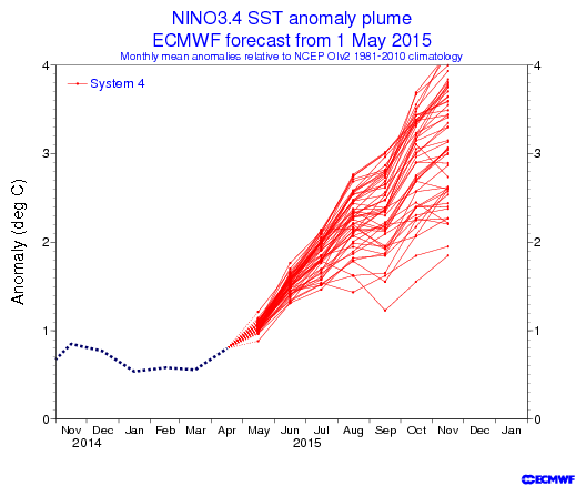
Figure 2
Now consider that NINO3.4 sea surface temperature anomalies peaked at +2.7 deg C in December 1997 in response to the 1997/98 super El Niño, and peaked at +2.8 deg C in January 1983 during the 1982/83 El Niño. See Figure 3, which is from the April 2015 Sea Surface Temperature (SST) Anomaly Update.

Figure 3
ARE NOVEMBER SEA SURFACE TEMPERATURE ANOMALIES OF +4.0 DEG C AND HIGHER IN THE NINO3.4 REGION PHYSICALLY POSSIBLE?
In the post Why Do El Niño and La Niña Events Peak in Boreal Winter?, we illustrated and discussed how and why the sea surface temperatures (absolute) of the NINO3.4 region mimic the seasonal cycle of, and come near to the values of, those in the western equatorial Pacific (5S-5N, 120E-165E) during a strong El Niño, like the one in 1997/98.
Based on the Reynolds OI.v2 data, the average November sea surface temperatures for the NINO3.4 region for the period of 1981-2010 is 26.64 deg C. That value serves as the November reference temperature for NINO3.4 sea surface temperatures anomalies.
Sea surface temperatures in the western equatorial Pacific (5S-5N, 120E-165E) are naturally warmer than those of the NINO3.4 region. The November sea surface temperature for the western equatorial Pacific in 2012 was 29.95 deg C; in 2013 the temperature there was 29.98 deg C; and, for 2014, it was 29.90 deg C. The average November temperature for the western equatorial Pacific for the past 3 years was about 29.94 deg C.
Let’s assume for a moment that the sea surface temperatures in NINO3.4 region did something very unusual in November 2015 and rose to that 2012-2014 average value of the western equatorial Pacific of 29.94 deg C. The November 2015 NINO3.4 sea surface temperature anomaly would be 3.3 deg C. That’s far short of 4 deg C.
Because someone’s bound to ask, in November 1997, the sea surface temperature for the western equatorial Pacific was 29.35 deg C, while the NINO3.4 region was remarkably similar at 29.31 deg C. And for November 1982, the sea surface temperature for the western equatorial Pacific was 29.08 deg C, while the NINO3.4 region was a little less at 28.81 deg C.
[My thanks for the heads-up, anonymous person.]
SOURCE
The Reynolds OI.v2 sea surface temperature data are available from the KNMI Climate Explorer.
Models, models everywhere, and not an accurate prediction to make….
The computer made me do it.
The programmer made the computer make me do it.
Models all the way down.
“Models, models, everywhere and all the trends did stink..”
The question we would always ask at Intel for something like this was:
“how much of your salary/retirement would you bet on this being correct?”
Ahh, a subjective naive prior, the gateway to Bayesian probability/inference.
Surely the Gavinator and his entire department will bet their entire year’s salary along with Richard Betts and Dame Slingo of the Met Office in England.
At least, if they had any honor at all, they should.
How much do you think Betts and Slingo sweeten the pot? Maybe Gav should just add a few hundred in cash to the pot, instead. Betts and Slingo would be hard to monetize.
You would think that when the majority of their runs produce something not just unprecidented but physically impossible, they might conclude their model is wrong. Instead, they publish it and embarass themselves.
OTH, you found Trenberth’s missing heat. It was hiding inside the ECMWF model.
Right on the money as usual, rv. Many thanks,
an (aka pokerguy)
Bob,
From a historical perspective, what are the odds of a weak/stalled El Nino in one year, intensifying significantly in the following year?
Rob, according to NOAA’s ONI index…
http://www.cpc.ncep.noaa.gov/products/analysis_monitoring/ensostuff/ensoyears.shtml
…the 1986/87/88 El Nino strengthened during the second year, but peaked earlier in the year than normal.
This year, there’s still a large pool of warmer-than-normal water below the eastern equatorial Pacific, so the El Nino conditions should strengthen somewhat from where they are now.
Much will depend on if and when we get more westerly wind bursts. We need them to push more warm water from the western to the eastern equatorial Pacific.
Cheers
http://www.cpc.ncep.noaa.gov/products/analysis_monitoring/ensostuff/detrend.nino34.ascii.txt
1997 3 27.15 27.34 -0.19
1997 4 27.98 27.81 0.18
1997 5 28.63 27.91 0.71
1997 6 28.86 27.69 1.17
1997 7 28.86 27.28 1.58
1997 8 28.69 26.92 1.76
1997 9 28.89 26.83 2.06
1997 10 29.13 26.79 2.34
1997 11 29.12 26.74 2.38
1997 12 29.04 26.69 2.35
1998 1 28.98 26.68 2.30
1998 2 28.72 26.84 1.88
1998 3 28.67 27.34 1.33
1998 4 28.66 27.81 0.85
1998 5 28.48 27.91 0.57
1998 6 27.42 27.69 -0.27
How about all the many data insufficiencies? The badly maintained floating equatorial stations? Those that have contributed to so many failed El Nino predictions in the past?
Orson, the moored TAO project buoys have been supplemented by drifting buoys for a few decades. And there are satellite measurements thrown in too.
Also, add a volcanic eruption, major or minor and when it appears that Nino died in its
crib or was a changeling, the volcano will be blamed…
just saying..
Thanks, Bob. If the ECMWF model is correct we’ll probably have some El Niño warming to keep the pause going.
But if it is correct about the increasing strength of the ongoing El Niño, global warming would resume.
Some charts that are important for the ENSO (updated to April 2015).
First, the Pacific ocean equatorial upper ocean temperature anomaly (probably the most accurate leading indicator for where the ENSO is heading).
Keep in mind, most of this temperature anomaly is actually below the surface at about 150 metres depth and mostly represents warm or cold water flowing to the East in the Pacific Equatorial Under-Current. It is not at the surface, as in a Kelvin Wave but it is the temperatures in the deeper ocean current which carries the most mass of water on the planet of any current. Large increase in the last few months (which is leading to the expectation of a large El Nino this year but there was also a large increase last year which did not result in a large El Nino).
http://s14.postimg.org/b74jrvcyp/Nino_34_vs_EUOTA_Apr15.png
In the last few weeks, this temperature anomaly has been decreasing (which again is exactly what it did at this time last year).
http://s4.postimg.org/9oo2b3831/EUOTA_Weekly_May15.png
The Trade Winds haven’t been doing much lately. An El Nino will need these winds to slacken by a huge amount (as in 1997) to produce a large El Nino.
http://s2.postimg.org/h3mvli4xl/Nino_34_vs_Trade_Winds_Apr15.png
Last several days have seen some extra slackening however.
http://www.cpc.ncep.noaa.gov/products/analysis_monitoring/enso_update/ua850_c.gif
And then lastly, Water Vapor. If an ENSO is going to impact global temperatures, there needs to be a large jump in water vapor levels but not much is really happening at this early stage of the ENSO.
In addition, the ENSO seems to be, by far, the most important driver of water vapor levels. It is not increasing anything like predicted in the theory and, since the ENSO seems to be the big driver of it and there is no increasing trend in the ENSO, as in more El Ninos are NOT occurring, as in there has been no change in this oscillation since the start of the record in 1871, one might be tempted to say the global warming theory got this wrong. At least half of the total warming expected comes from increased water vapor. If this is flat or only increases at half the rate expected, then the large warming will simply not happen.
http://s22.postimg.org/4g25h2p3l/Nino_34_vs_PCWV_Apr15.png
Thanks for the updates, Bill.
No chance of a strong El Nino. It is worth observe the temperature at a height of 3500 m.
http://earth.nullschool.net/#current/wind/isobaric/700hPa/overlay=temp/equirectangular
Bill Illis .comment-author .vcard May 16, 2015 at 9:19 am
…Large increase in the last few months (which is leading to the expectation of a large El Nino this year but there was also a large increase last year which did not result in a large El Nino)….
When there is a large increase that does not result in an El Nino, where does the heat go?
Clearly, global warming is causing disruption in the functioning of our high-tech society, leading to computer malfunctions that are only to increase in frequency and amplitude until planes start falling out of the sky and our cars act to murder us. We must act now to control our emissions.
This is just to get the politicians in the right mood for Paris, although if it doesn’t happen……OOPS.
James Bull
That was my first thought James. Give the shysters in Paris one more thing to point at so we become convinced to turn over our lives to them.
Joe Romm is in ecstasy over the possibility of a huge elNino breaking the pause. Too funny.
To me the ~1992-1995 and 2002-2006 action seems more like what we are getting now. Hope it brings some moisture to California as they are in need of it.
And there was me thinking Rantin’ Romm didn’t want the world to warm up…
he’s just an alarm-junky
forget global warming, climate change, extreme weather, irritable climate syndrome……..
it’s weather
What does this mean for California?…..rain or no rain?
@TRM, and @Latitude,
Watch Joe Bastardi’s weekly weather forecast. He talks about CA.
First time I’ve watched Joe Bastardi’s informative and entertaining Saturday Summary. Thanks for the link.
Exactly – rain or no rain. Whichever it is, it will be bad, and the fault of fossil fuels.
I agree. At least half of their model run predictions are physically impossible. The western warm pool temperatures vary a lot less than el-nino temperatures. Their upper limit changes even less. You have shown how the Kelvin wave ties the two temperature changes together. Their models apparently do not include the Kelvin wave effect.
Jamstec and IRI blend usually best on this matter Weatherbell predicts similar enso event to 57-58, 65-66 should peak before winter, and shrink back to enso 3.4 warmer than 1.2 a marker for a cold winter. Look for major flop to global temp dropping la nina within 3 yrs. Before that though, get ready , the agenda offendas are coming out in full force. You think its bad now with their global temps, wait till this cranks more
Thanks, Joe. With all those graphs and alphabet soups, sometimes I need a weatherman to tell me which way the wind’ll blow.
btw that warm water still around Australia is a huge negative for the trades cranking up enough for ECMWF idea. We see some fairly good soi drops as we are having now, but nothing like the kind of set up we had in 97-98 as the water was very cold around Australia by now, meaning high pressure and the slow down of the trades. Same problem last year, though this year its off to a warmer start in enso 3.4. Interestingly enough the CFSV2 this am had many more colder recent runs ( blue) than its average.
http://origin.cpc.ncep.noaa.gov/products/people/wwang/cfsv2fcst/imagesInd3/nino34Sea.gif
and the earlier peaking. 1.2 noticeably lower
http://origin.cpc.ncep.noaa.gov/products/people/wwang/cfsv2fcst/imagesInd3/nino12Sea.gif
Jamstec under all of them, like it was last year
Thanks, Joe. Great Saturday summary! I too watched Superchicken way back…
SOI drops? According to KNMI SOI just popped positive.
Here is a CPC/NCEP plot of a few predictions. A lot of diversity, but some fairly super
http://www.cpc.ncep.noaa.gov/products/NMME/current/images/nino34.NMME.png
Hey, Nick!
Let’s take an average of all those predictions. Then we’ll know what to expect… right?
Nick that science looks pretty settled alright
GCR growth will weaken southern polar vortex and larger cooling the South Pacific.
http://www.bartol.udel.edu/~pyle/thespnplot2.gif
Last week on Joe Bastardi’s Saturday forecast, he talked about (and showed) the warmth in the waters around Australia now. Then he showed the waters around Australia at the start of the 1997/98 El Nino: it was cold. Ditto 1983. So his prediction was that this year’s El Nino was not going to be a super El Nino. He said the water surrounding Australia has to be cold for a super El Nino, and explained why.
I just checked his site because sometimes he doesn’t put the new report up until later in the day. But May 16th’s report is up now. He talks about this year’s El Nino, and it’s nowhere near as dramatic as the ECMWF above.
Ah, I was typing as Mr. Bastardi himself was explaining.
The alarmist narrative desperately requires those ‘predictions/projections’ to be true in order to validate the excuses made ex post facto for the near 20 year pause.
If it doesn’t happen they have a real problem.
My position is that the quiet sun is increasing global cloudiness by a means I have set out elsewhere and reducing solar energy getting into the global oceans so that the balance between El Nino and La Nina within the ENSO cycle is moving towards weaker El Ninos and stronger La Ninas for, eventually, a net cooling effect.
If Bob thinks the predictions are physically unfeasible then I go with that. I don’t know any other researcher with even a fraction of his knowledge in this subject.
>The alarmist narrative desperately requires those ‘predictions/projections’ to be true…
Since when?
>If it doesn’t happen they have a real problem.
Not really, if accuracy in forecasting was important to alarmists they’d have faded away by now, I can’t think of a single alarmist prediction that has come true in 25 years. Something else is driving this, and it certainly isn’t any actual threat of catastrophic warming.
The excuse to tax everyone’s energy use is irresistible. Governments use the money gathered this way for other nefarious purposes. They then tell angry people paying high energy prices that this will save the planet from burning up.
Cold, snowy winters and colder than normal summers are screwing this up for our rulers.
Looks like more pre-Paris fever.
Dead on!
Ocean oscillations are just that, oscillations. If a major high happens, a major low is lurking.
So do these models rely on global warming models as an input. In essence basing El Niño on CO2 levels?
Dave, these are long-term weather models (about 6 months), not climate models.
http://www.ecmwf.int/en/forecasts/tools-and-guidance/documentation-and-support/long-range
i’ll believe in El Nino when he gets to #Failifornia…
until then, this is all just wishcasting
Just wait….the Anchovies know…
The current sea temperature.
http://oi61.tinypic.com/2hf6mat.jpg
That’s a nice picture. I wonder what the cell sizes are?
http://www.ospo.noaa.gov/data/sst/contour/global_small.fc.gif
Ren ST diagram. Looks right in Sydney where the sea temp is currently around 20 C whereas normally around this time in other years it would be 16 to 17 C.
Also it might be El Nino but we are still getting consistent rain no doubt says the BOM due to the higher sea temp.