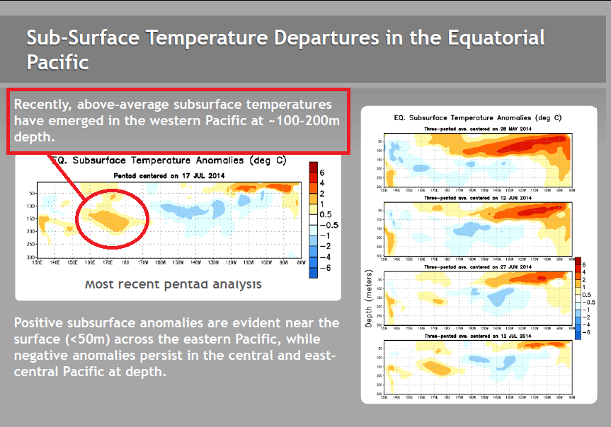
 There may still be a chance for an El Niño during the 2014/15 ENSO season. A new “pocket” of warm subsurface water has formed in the western equatorial Pacific. See the note in the page from the most-recent NOAA Weekly ENSO Update to the right. (Please click on illustration for full-sized image.) In their update, NOAA also makes note of that anomaly during their discussion of the Hovmoller on their page 15. That subsurface temperature anomaly appears to have been caused by the recirculation of warm water from the earlier downwelling (warm) Kevin wave, not by another westerly wind burst. Come along, I’ll show you.
We’ve illustrated and discussed in recent posts the quickly diminishing remnants of the strong downwelling Kelvin wave that had carried a large pulse of warm water from the western equatorial Pacific eastward as far as South America. See…
- Part 11 – Is the El Niño Dying?
- Part 12 – July 2104 Update – The Feedbacks Need to Kick in Soon and
- Part 13 – More Mixed Signals…
…of this series. And the bottom line of those posts was, if the trade winds along the equatorial Pacific did not start to provide the feedback necessary to support an El Niño, the 2014/15 El Niño was going to die an early death…basically, it would run out of warm water.
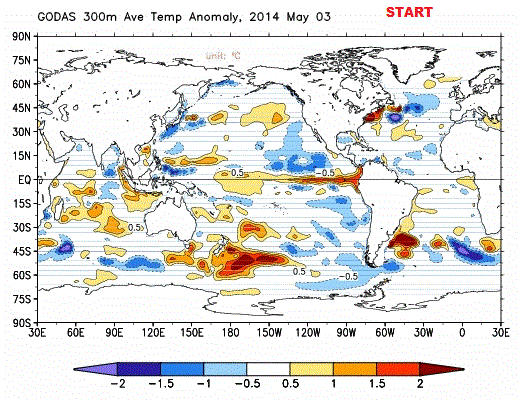
Now a warm subsurface temperature anomaly has appeared in the west-central equatorial Pacific. See Figure 1, which is the most recent (a 5-day average centered on July 22) equatorial cross section available from the NOAA GODAS website. That pocket of warm subsurface water has been there, growing stronger, for the past few weeks.
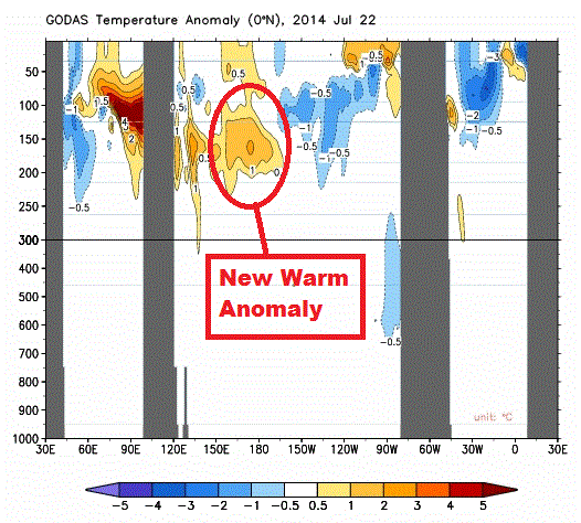
Figure 1 – Equatorial Cross Section
Yet, according to the equatorial wind stress data, there has not been a westerly wind burst in the western equatorial Pacific for a few months to nudge any warm water from the West Pacific Warm Pool. See Figure 2. So where’d the warm water come from?
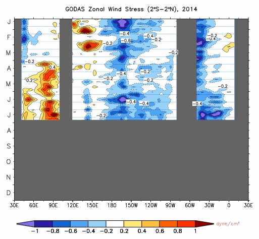
Figure 2 – Wind Stress Hovmoller
For that, we’ll have to look at an animation of the temperature anomaly maps for the top 300 meters of the oceans. But before we do, let me first show you what you’ll be looking for. See Figure 3. There is a pocket of warm water off the equator near the dateline. That pocket of warm water will be isolated as the equator cools. It travels slightly west and then gets “drawn” to the equator again.
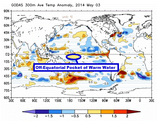
Figure 3
And in Animation 1 you can watch that transpire. The animation starts with the May 3rd pentad (5-day average) and runs through July 22nd.
Animation 1
For those interested in watching the off-equatorial pocket of warm water form, see the animation here of sea level anomaly maps and temperature anomaly maps for the top 300 meters of the oceans from July Update. The “T300” maps are on the right. That animation runs from the start of the year to July 2, 2014, so it does not capture the warm water returning to the equator. That’s only happened over the past few weeks.
Animation 2 includes the equatorial cross sections for the same time period. Yes, there are other positive subsurface anomalies west of the one nearer to the dateline, so without the T300 maps, it’s difficult to speculate about how the larger warm anomaly formed.
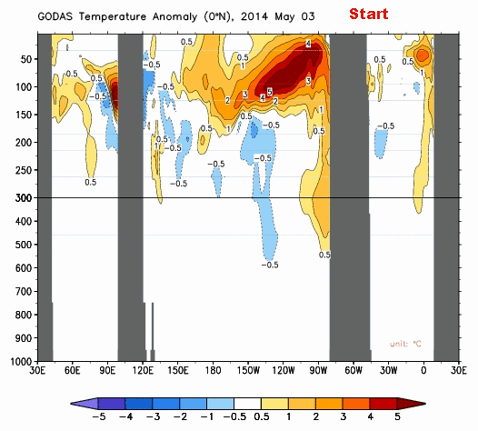
Animation 2
BOTTOM LINE
Regardless of where that warm anomaly originated, it’s there now. The equatorial undercurrent in the Pacific (a.k.a the Cromwell Current) should now carry that anomaly to the east, where it should become a more-positive anomaly (because the water in the east is normally cooler than in the west). And if that additional warm water just south of the equator in the western tropical Pacific should also feed into the equatorial undercurrent, then there will be even more warm water to possibly fuel an El Niño for this year. (Yeah, I know, there’s lots of “shoulds” in those sentences, leading up to a “possibly”.)
We’ll just have to watch and see what Mother Nature decides to do. She’s always in control…and she’s always full of surprises.
EARLIER POSTS IN THIS SERIES
- The 2014/15 El Niño – Part 1 – The Initial Processes of the El Niño.
- The 2014/15 El Niño – Part 2 – The Alarmist Misinformation (BS) Begins
- The 2014/15 El Niño – Part 3 – Early Evolution – Comparison with 1982/83 & 1997/98 El Niño Events
- The 2014/15 El Niño – Part 4 – Early Evolution – Comparison with Other Satellite-Era El Niños
- The 2014/15 El Niño – Part 5 – The Relationship Between the PDO and ENSO
- The 2014/15 El Niño – Part 6 – What’s All The Hubbub About?…
- The 2014/15 El Niño – Part 7 – May 2014 Update and What Should Happen Next
- The 2014/15 El Niño – Part 8 – The Southern Oscillation Indices
- The 2014/15 El Niño – Part 9 – Kevin Trenberth is Looking Forward to Another “Big Jump”
- The 2014/15 El Niño – Part 10 – June 2014 Update – Still Waiting for the Feedbacks
- The 2014/15 El Niño – Part 11 – Is the El Niño Dying?
- The 2014/15 El Niño – Part 12 – July 2014 Update – The Feedbacks Need to Kick in Soon
- The 2014/15 El Niño – Part 13 – More Mixed Signals
And for additional introductory discussions of El Niño processes see:
- An Illustrated Introduction to the Basic Processes that Drive El Niño and La Niña Events
- El Niño and La Niña Basics: Introduction to the Pacific Trade Winds
- La Niñas Do NOT Suck Heat from the Atmosphere
- ENSO Basics: Westerly Wind Bursts Initiate an El Niño
FURTHER READING
My ebook Who Turned on the Heat? goes into a tremendous amount of detail to explain El Niño and La Niña processes and the long-term aftereffects of strong El Niño events. Who Turned on the Heat? weighs in at a whopping 550+ pages, about 110,000+ words. It contains somewhere in the neighborhood of 380 color illustrations. In pdf form, it’s about 23MB. It includes links to more than a dozen animations, which allow the reader to view ENSO processes and the interactions between variables.
I’ve lowered the price of Who Turned on the Heat? from U.S.$8.00 to U.S.$5.00. A free preview in pdf format is here. The preview includes the Table of Contents, the Introduction, the first half of section 1 (which was provided complete in the post here), a discussion of the cover, and the Closing. Take a run through the Table of Contents. It is a very-detailed and well-illustrated book—using data from the real world, not models of a virtual world. Who Turned on the Heat? is only available in pdf format…and will only be available in that format. Click here to purchase a copy. Thanks. (I also am very happy to receive tips or donations.)
Thanks, Anthony.
I sure hope we can enjoy an El Niño. I would love to have a winter in the Midwest with mild temps. and greatly reduced snowfall. It would be great if my snow blower could be inactive all winter and remain in the corner of my garage. Global warming in the winter time would be wonderful.
Until there is a significant slackening of trade winds there is not going to be a Nino. While they are slack in the far western Pacific, they are basically nominal elsewhere. Still looks like more “La Nada” to me at least for the next several weeks.
Oops, forgot. Over the past week, sea surface temperature anomalies [correction: sea surface temperature anomalies of the NINO3.4 region of the equatorial Pacific] have dropped well below zero:
http://www1.ncdc.noaa.gov/pub/data/oisst/navy-anom-bb.gif
Nominal trade winds, enlargement of antarctic down welling cold is pushing the SH jets closer to the equator effectively breaking up any chance of an oscillation occurring. Enlargement of arctic cold area has already begun pushing the NH jets to the equator. By the time we reach equinox there will be opposing forces that will not allow oscillation to begin.
IF the area of cold water intrudes from the north this warm pocket will be depleted in short order. (and this one is likely to occur if we get a hurricane formation.)
El NOPE!
excuse me, typhoon formation…
Fascinating, as always. One question: Ian Plimer told me some years ago that seismic tremors became more active in the Pacific for six months before each el Nino. Is this a possible cause for the warmer water every few years; and, if not, what does cause it?
Thanks Bob!
I’d also be interested in seeing Joe Bastardi’s analysis of this. Wouldn’t mind a milder winter and I have friends in California who could use the rain.
Monckton of Brenchley, you have to be kidding. I get more hot flashes in the six months before each El Nino. Wonder what that connection is between my hormones and the top few meters of the equatorial Pacific ocean.
Pamela: It depends on how close you get to that “warm” water.
The odds of an El Nino seem to be shrinking daily. For some reason, there was never an “atmospheric” hook up.
Monckton of Brenchley says: “Fascinating, as always. One question: Ian Plimer told me some years ago that seismic tremors became more active in the Pacific for six months before each el Nino.”
Hi Christopher. I’ve never seen seismic data that confirms or contradicts the statement, nor have I ever seen it mentioned before now.
Regards
It looks like the El Nino is dead now.
But that warm patch you mentioned should recirculate toward the equatorial Pacific Warm Pool area. There is a monthly animation of this counter-current at 8S from Godas – every month going back to 1979. Kind of hard to see what is going on in here but that is what it does. Its a long animation so it is only for those truly interested in this.
http://www.cpc.noaa.gov/products/GODAS/mnth_gif/xz/movie.temp.8s.mon.gif
El Nino is caused by a slackening of the trade winds that blow from East to West along the Pacific ocean equatorial band. This video gives a history of the discovery and developing understanding of the root cause of trade winds, the Coriolis Force.
This video explains why the trade winds slacken due to weakened and reversed pressure systems along the equatorial band.
And finally, this is a Yale presentation the delves deeper into El Nino and La Nina processes.
There is also a song dedicated to this topic but it was so pot smoking stupid I just can’t paste the youtube here and call myself intelligent. If you want to venture into such a weird realm, use the following search phrase at youtube.com. If you’re like me, you will slap yourself for watching it.
EL NINO – PERFORMED BY ‘BODY’
did anybody ever predict a nino / nina acurately?
I remain very confident that weatherbell.com forecast for an enso event similar to 02-03 and 09-10 is on the way. This is a cold pdo/meI REACTIVE event, a bounceback similar to how la ninas during the time of the warm pdo/met periods can occur. We are highly unlikely to have a super nino until the PDO gets ready to flip for good again, Basically we are seeing what we have seen before if you go back and look at the 50s-70s. The warmest of the events, such as 57-78, 65-66,72-73 collapse quickly. The very nature of the enso with the warming where it is when the decadol signal of the PDO is cold, invites the destruction of the warm water pool. YOU MUST HAVE SOME SOI LINKAGE because if not, then the warm subsurface water simply cools coming to the surface and you just saw that. There should be a few months of linkage in the fall, as the water is cooling a bit around Australia and this will lead to the higher pressures needed to link the SOI So yes it is coming and I think our those analogs will prove to have had merit. Please remember, my counters have been to take apart the Super Nino crew which since 1997 has been wishcasting super nino though the cold guard lead by Hansen apparently have new heirs to carry on. No one said there would be no el nino and to be frank, this is how we felt it would evolve, because we kept harping on the lack of coupling ( linkage) that should occur through in the coming months.
That warm water pool is not by itself that significant, as if there is no linkage to the SOI, it will cool again, only it isnt as warm as the one that set some flipping out back in April.
BTW there is a reason they call it “el nino” it shows up later in the season but the ones that do are not the super nino’s and that is where the main thrust against Trenberth etal, was.. that it was irrational exuberance given the physical players on the field to be yelling about super ninos..IMO ( Joe D’s too)
cheers
I return to an earlier observation I have seen in the El Nino data. It appears that the amplitude of El Nino’s generally increased up until the 1998 El Nino. Since then the amplitudes have generally decreased. This observation appears to mesh with Bob Tisdale’s discharge/recharge phenomenon. The tank empties in stepwise fashion with each step being steeper up to a point (thus also connecting to the increasing stepwise global temperature series). The tank hits a peek amplitude then slowly slides down as measured by El Nino amplitude thus connecting to the pause. What conditions of discharge/recharge would have to be in place for global temperatures to fall?
hmmmmm.
Thank you for this article. It answers my question on your last thread.
Yes, the El Nino may be happening – the predictions aren’t wrong – but the size of the temperature anomaly looks like it will be weaker than would have been expected last decade.
Interesting. And it looks like we are beginning to get an understanding of this and are able to make worthwhile predictions. This is progress and you seem to be at the forefront.
Monckton of Brenchley says:
July 26, 2014 at 9:11 am
The hypothesis linking El Niños & volcanism has been around at least since 1988:
http://www.nytimes.com/1988/11/29/science/theory-ties-earthquakes-in-pacific-to-el-nino.html
It has taken me some time to learn how to read Hovmoller graphs. See Figure 2 – Wind Stress Hovmoller. Think of it as a flip book animation but shown on one page instead of several. Play the animation by slowly scanning down the graph to see how things change or move locations over time designated on the y axis in the geographic area span designated on the x axis.
Pamela Grey at 9:25
A wise person told me “THOSE ARE NOT HOT FLASHES those are POWER SURGES ! ”
I’m sure you agree…..(: < ))
re: volcanic events and El Ninos
Milodonharlani, a super large equatorial eruption in the Indonesian area appears to be able to initiate an El Nino event, likely due to disrupting the atmospheric pressure cell mechanism that drives normal trade wind conditions from East to West, IE the western Pacific ocean high pressure cell and its interaction with the Coriolis Force setting up the Walker Cell equatorial circulation. It seems that ash and sulfur obscuring the Sun is the primary agent, which makes sense.