Guest Post by Willis Eschenbach
In a post here on WUWT, Nils-Axel Morner has discussed the sea level in Kwajalein, an atoll in the Marshall Islands. Sea levels in Kwajalein have been rising at an increased rate over the last 20 years. Nils-Axel pointed to a nearby Majuro tidal record extending to 2010, noting that there’s been no acceleration there. A furor seems to have erupted in the warmosphere over his comments, with folks like Tamino pointing out that we have tidal data for Majuro up until 2013, not just 2010 as Nils-Axel highlighted, and those final three years show higher rates of sea-level rise, so indeed there is acceleration there …
Bemused by the excess of heat over light, and dismayed by the battle over twenty-year sea-level trends, as a long time sailor and commercial fisherman with more than a bit of knowledge about tides, let me say that they’re all wrong, warmists and skeptics alike. Here’s the critical graph for any discussion of sea-level rise and fall:
 Figure 1. Confidence intervals for the estimation of sea-level rise using tidal gauge data. This means that 95% of the results fall between the two extremes. For twenty year trends, these are from a sea-level rise of three mm/year to a sea-level fall of three mm per year. See endnotes for the corresponding equation. SOURCE: Pacific Country Report, Sea Level & Climate: Their Present State Marshall Islands December 2010
The interpretation of Figure 1 is as follows. Let’s consider twenty-year trends in sea level rise. The uncertainty is 2.8 mm per year … which is about equal to the global average sea-level rise itself.
Now, twenty-year trends are convenient because trends of that length are under discussion by Morner and the rest. It’s also convenient because we have twenty years of satellite records, as well as twenty years of SEAFRAME records in Majuro. The uncertainty in Figure 1 says that IF there were absolutely no change in global sea levels over time, about one tide gauge out of every six would show the sea levels as rising between 1.5 and just under 3 mm per year over twenty years. Another one in six tide gauges would solemnly assure us that the sea level is falling between 1.5 and 3 mm per year over the same twenty years.
SO … if you see a couple of twenty-year trends from two tide gauges that differ by say four mm per year, that is an EXPECTED RESULT of the short length of the data. Let me explain why the uncertainty is so large, and then we’ll look at the Marshall Islands sea level data. The problem is the tides. The ocean tides are a driven resonant system. By “resonant” I mean that ocean water “sloshes” back and forth in the ocean basins, just like the water in a wide basin after you set it down. Each ocean basin has natural resonant periods. The driving forces are the gravity of the sun and the moon. They vary in a hugely complex cyclical motion, which sort of repeats only after over fifty years. The basins have long- and short-period “standing waves” on the surface, or rather waves circulating around a wandering “amphidromic point” where there is no tide. There is no known way to predict what the combination of driving force, natural sloshing, and standing waves will look like at any given point for a given ocean basin. As a result, you have to wait for at least 50 years to get an accurate reading of the rate of sea-level rise. With shorter records, the uncertainty rises rapidly, and with 20-year records, the 95% CI is ± 3 mm per year.
With that as a preface, let’s take a closer look at the sea level rise in the area. First, where are these mysterious “Marshall Islands”, and how many tide gauges in the Marshall Islands have records up to the present?
Figure 2 shows the location of the three tide gauge records in the Marshall Islands that extend up to the present. They are at Wake Island, Kwajalein, and Majuro. The Majuro tide gauge is part of the “SEAFRAME” sea-level measurement project.
 Figure 2. Location of Majuro (the capital), Kwajalein, and Wake Island in the Marshall Islands. Australia is at the lower left. Papua New Guinea is the large turkey-shaped island at center-left. The islands in the chain to the right of Papua New Guinea are the Solomon Islands
Now, what do we know about the sea levels at those points? Here are the three records. I’ve spliced together the recent and the previous record at Majuro (Majuro B and Majuro C), as they are nearly identical in their overlap periods. Here are the three records.

Figure 3. All available tidal records which extend to the present, Marshall Islands. Heavy lines show 6-year centered Gaussian averages of the data.
You can see the post-2010 uptick at the end of the Majuro record (red) that Tamino referred to. Now, the whole hoorah has been about the trend of the last 20 years in Kwajalein. The records for Kwajalein and Majuro differ by about 4 mm per year … remember what I said about 4 mm per year above? Not meaningful.
Now, we do have one other source of information about the sea level rise in the Marshall Islands. This is the satellite record. At the time of writing, you could find the satellite sea-level record for any spot on the ocean at the University of Colorado “Interactive Sea Level Time Series Wizard” (it currently says “Under Revision”). Figure 4 shows those results. I’ve left out the annual results this time, and just shown the Gaussian averages, so we can get a sense of the difference between the tide gauge records and the satellite records.
 Figure 4. Gaussian averages of the three tidal gauge records shown in Figure 3. In addition, the satellite records for the same location are shown, aligned to the average of the first five years of the common period of record.
I show the data from 1970 so we can compare recent records (last twenty years, back to the early 1990s) and early records (previous 20 years, early 1970s to early 1990s. Now, there are a few oddities here. First, although the satellite records generally “wiggle-match” the tide gauge records, the agreement isn’t all that great.
Next, of the three dataset pairs (satellite and tide gauge), two of the pairs (Wake Island and Majuro) end up together after 20 years. At Kwajalein, on the other hand, the tide gauge record ends up about 50 mm above the satellite record … the cause of this divergence is unknown. It appears to start in 2003, and it may be something as simple as the dock where the tide gauge is located slowly sinking into the sand … or not.
The most internally consistent data that we have, the satellite records, show little difference between the rise in Majuro and Kwajalein over the last 20 years. One is 6.4 mm, one is 7.4 mm … be still, my beating heart.
So Nils-Axel and Tamino are both wrong. We can’t conclude anything either way by comparing Majuro and Kwajalein. Their records are far too short and too similar.
Finally, how unusual are these three satellite-measured trends at Wake, Kwajalein, and Majuro, of 2.1, 6.4, and 7.4 mm respectively? Well, to answer that, I took the approximately half a million areas of the ocean for which the satellite has measured the trends from the University of Colorad, and made a histogram …
 Figure 5. Histogram of the sea level trends for each 0.25° square gridcell of ocean area from 89.5 North to 89.5 South.
Now, the trends shown in Figure 5 are 20-year trends. Recall from Figure 1 that the 95% confidence interval on tide gauge records was estimated at just under ± 3 mm. The 95% confidence interval on these satellite measured trends in Figure 5 is somewhat larger, at ± 5 mm per year. Note also that about 12% of the gridcells show a decrease in the sea level, and thus they have a negative trend.
Finally, you need to be aware that the trend that is shown by the tidal gauge data is NOT the rate of sea-level rise, for a couple of reasons. First, what you are seeing is the rate of global sea-level rise PLUS the tidal effect from the sun, the moon, and the shape and resonant frequency of the basin. The means used for removing those tidal effects is beyond the scope of this discussion (see Mitchell for details under “Asymptotic Trend Evaluation”). However, generally what has to be done is the 112 different major solar/lunar tidal components are estimated from a tidal record to date at a specific location. Then the “best guess” estimate of the combined tidal effect is subtracted from the observed change in sea level. What remains is the best estimate of the actual change in the underlying sea level, but it still needs to be corrected for the land uplift/subsidence.
So for example, the measured change in the sea level at the Majuro B (SEAFRAME) tide gauge was +5.6 mm/year 1993-2010. But after subtracting the tidal effects, it drops to 4.3 mm/year. And after removing land subsidence effects, the actual trend was estimated by the SEAFRAME folks at 3.8 mm/year.
To complete the circle, here are the Majuro and Kwajalein tide gauge and satellite records, aligned on their 1995-2000 averages.
 Figure 5. As in Figure 4, but with the Majuro records adjusted upwards by 59 mm so that they are all aligned on the average of their 19/95-2000 period.
SUMMARY: TIDE GAUGE AND SATELLITE DATA, MAJURO AND KWAJALEIN
• The early (1973-1993) and late (1993-2013) trends in Majuro were about the same.
• In Kwajalein, the early trend was about flat, and the later trend was quite steep.
• Given the close physical proximity of the two atolls, and the similarity of the two satellite records, one or the other of the tidal records may contain an error.
• After about 2003, the Kwajalein record wiggle-matches with the two satellite records. The Majuro record does not. On the other hand, after diverging from the two satellite records in 2003, the Majuro record ends up agreeing with them, while the Kwajalein record ends up ~ 50 mm higher than the other three. Go figure.
° The post-1993 Majuro tide gauge “B” is a modern design acoustic SEAFRAME gauge, and is presumably quite accurate.
• There is absolutely no statistical significance in the ~4 mm difference between the 20-year tide gauge trends for Majuro and Kwajalein. And the satellite trends, as you can see above, are nearly identical.
• In short, there is no evidence for or against an acceleration in sea-level rise in the three Marshall Islands records.
Best to all,
w.
DATA AND CODE: Spreadsheet is here … enjoy
UNCERTAINTY EQUATION—The empirical equation relating years of record (YR) and uncertainty (one standard deviation) is:
Uncertainty (mm/yr) = 0.102 * EXP( -4.939 * EXP( -0.02 * YR ) )
This says that with a fifty-year record we still have an uncertainty of plus or minus two-thirds of a millimetre per year, or 63 mm (2.5 inches) per century.
If a skater spinning puts their arms out their rotation speed slows.
If there is a sea level rise, then you must be able to detect it in the rotation speed of the earth.
If the gauges are on different sides of the islands, then presumably prevailing winds would have an effect linked to enso?
It might be a good idea to wait for a reply from Nlis-Axil Morner since he is still the world’s sea level expert.
Land movement can be different between two close oceanic islands which could explain the difference between these two Marshall (unrelated) Islands.
Nick says:
August 2, 2013 at 3:08 am
[snip]”If there is a sea level rise, then you must be able to detect it in the rotation speed of the earth.”
I don’t think so. Warmism (whether true or not) says that sea level rise comes from melting land ice. So the ice would be falling while the sea rises, pretty much canceling out.
(OT with apologies to Willis, please do note but do not respond)
Is Global temperature sensitivity for doubling of CO2 = 0.7C ?
Calculations from correlation of global land temperature to the geomagnetic Ap index indicates so as realistic possibility.
http://www.vukcevic.talktalk.net/Ap_LT.htm
Global Land Temperature (HadCru3) for the period 1880-1990 rose about 0.8C, it could be concluded that half of this is due to solar activity (via geomagnetic storms as measured by the Ap index) and the other half had to be attributed to all other factors including CO2 rise
Eustace Cranch 5:32
“I don’t think so. Warmism (whether true or not) says that sea level rise comes from melting land ice. So the ice would be falling while the sea rises, pretty much canceling out.”
The ice is at the poles, near the axis of rotation, water moves to the entire globe and, in fact, bulges a little at the equator, so the effect would be there. I don’t know if it would/should be detectable.
“They vary in a hugely complex cyclical motion, which .”… You have a few words missing from that sentence, Willis
[Thanks, fixed. It was late … -w.]
“They vary in a hugely complex cyclical motion, which . ”
I suspect there are some words missing from the above sentence.
Quite so Willis. Figure 1 should be memorized by all as it very well demonstrates the fatuity of short term trends.
“In short, there is no evidence for or against an acceleration in sea level rise in the three Marshall Islands records.”
This statement is incorrect. Figure 5 shows clear evidence for an acceleration in SLR after 1990.
The mean of 18 tide gauge records from the central Pacific also shows an acceleration after 1990:
http://oi41.tinypic.com/11ak7sh.jpg
The question isn’t whether relative SLR accelerated in the Pacific after 1990, because it did. The question is what this acceleration signifies.
lowercasefred says:
August 2, 2013 at 5:46 am
The ice is at the poles, near the axis of rotation, water moves to the entire globe and, in fact, bulges a little at the equator, so the effect would be there. I don’t know if it would/should be detectable.
=============
there was a graphic the other day showing sea levels rising in the western pacific and falling in the eastern pacific. clear evidence of a delay in the “extra” water from the pole getting up to speed, and being pushed by the eastward rotation of the earth in a westward direction. 🙂
Nick-
The speed of rotation of the Earth was very recently discussed here at WUWT-
http://wattsupwiththat.com/2013/07/11/length-of-day-governed-by-earths-core-processes/
So it appears that sea level rise/land ice melt/earth’s rotational speed would be a highly non-linear relationship and probably not a useful metric.
I think we should correct your definition/explanation of a confidence interval (see figure 1). A 95% confidence interval will cover the true value of the thing we are trying to estimate on 95 out of of 100 occasions that we compute it. Each of those 95 out of 100 intervals will be different. In some cases the true value will be slap in the centre of the interval and in some cases it will be near the edge. So you are not correct when you imply that 95% of results will fall between the extremes of a single interval.
I am slightly suspicious that all of your intervals are centred on 0, especially those to the left
I doubt that this affects the point that you are making
Thanks Willis. I came across a reference to the tidal effect of the moon alone rising the sea six feet when overhead, and the crust of the earth some 16-18 inches. What we experience as solid is a lot more plastic than one might assume, and is in constant flux from within and without. With all the modeling and guess work, measuring millimeters seems specious.
Roger Andrews says: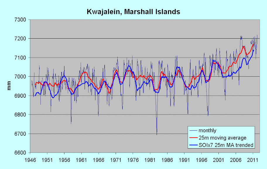
August 2, 2013 at 6:34 am
The question isn’t whether relative SLR accelerated in the Pacific after 1990, because it did. The question is what this acceleration signifies.
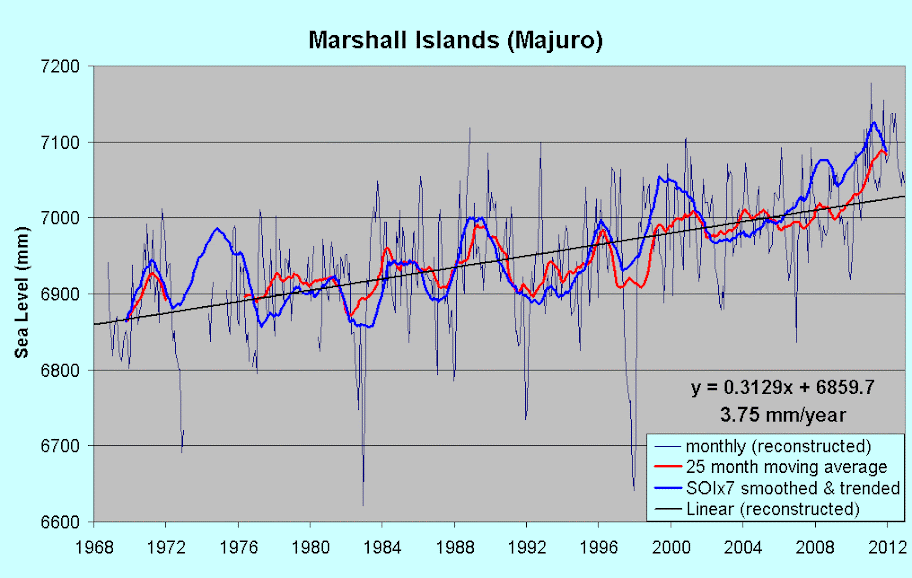
Indeed, and the answer’s simple – it’s ENSO. Sea-level at Kwajalein was trending down between 1976 and 1992, as SOI was trending negative. After then, SOI trended up to a positive peak in late 2010/early 2011, and has since dropped back to zero at present (June 2013). Sea-level has followed almost in lock-step, with an underlying upward trend, of course. Most south-western Pacific stations match those trends closely, including Majuro, Pago Pago, Pohnpei (FSM), to name but a few, and northern and western Australian stations also. Note the latter – it doesn’t chime in any way with what Mörner claimed here back in April.
Here are the relevant two, with an SOI multiple smoothed and trended added:
Kwajalein
and Majuro
Eliminating SOI by subtracting the multiple from monthly sea-level data removes the extreme lumps and bumps and the 1990s-present uptick entirely. I’m just about to post on both correlation and SOI removal, with Darwin and Fremantle included – the method works particularly well there.
Maybe it’s due to the missing heat hiding in the 700 to 2000 meter layer of the Pacific causing it to expand to 700.1 M, or thereabouts.
/sarc
johnmarshall says:
August 2, 2013 at 3:47 am
It might be a good idea to wait for a reply from Nlis-Axil Morner since he is still the world’s sea level expert.
———————————————————————————————
+1
studies of the effect of sea level rsie ( and ice cap melting) on rotational speed are out there.
One artcile in 1988 ( I forget the title) and this
http://www.scientificamerican.com/article.cfm?id=global-warming-shortens-day
@Willis:
I would be very interested in hearing more about areas where sea level is rising at an average 15 mm/yr. In 20 scant years, the sea level is reported to increase by a foot (~30 cm). What does that look like? Are these places anywhere near an island?
My bewilderment was why anyone would look at some islands and conclude anything. I ean, you are claiming that the Pacific Ocean is rising,which to me means it is rising EVERYWHERE. Look at
ocean levels all around the ocean on the shorelines, etc. if you want to determine Pacific sea levels. The ocean isn’t going to just rise at certain spots.
Nick, if you can gauge the change in length of a day to the microsecond, then please be my guest. That would very much be interesting. However, proving that it is due to sea level rise instead of any number of astronomical interferences or internal geological effects would be a challenge beyond the scope of possibility.
Actually I think there’s a point to expecting changes in earth’s rotation if sea level rises. Water from Ice melting in the polar regions would be assimilated into the oceans and shift the mass balance. On the other hand we have effects like humidity in the air creating a greater amount of drag against the surface and an increased mass of the oceans deforming the crust. Not an easy thing to fiddle apart.
How do the sea level data correspond to the altitude data?
I mean, there are probably Differential GPS stations at or near each location. Is it possible to compare the land “altitude” record from the GPS data to see if there’s any indication of subsidence/consolidation of the atolls themselves? Would this be unexpected, given that their formation is through hot spot volcanism?
Sea level rising across the pacific is not that daft an idea, given that the Pacific basin is (mostly) surrounded by subduction zones and is shrinking by 0.5km²/year according to the refs on wikiwassit.
Nick says:
August 2, 2013 at 3:08 am
“If a skater spinning puts their arms out their rotation speed slows.
If there is a sea level rise, then you must be able to detect it in the rotation speed of the earth.”
Yes. That’s LOD, Length Of Day.
http://tallbloke.wordpress.com/2009/11/29/planetary-solar-climate-connection-found/