Guest post by Bill Illis
We have often wondered what really causes the El Nino Southern Oscillation (ENSO) climate pattern. It is generally understood and this post will demonstrate that it is really driven by the Trade Winds over the ENSO region.
The Trade Winds blow East to West at the equator. Most of us living in other latitudes expect the wind and the weather to primarily come from the West but, at the equator, the weather comes from the East.
When the Trade Winds are stronger than average for a sustained period of time, the Trades literally blow or drag the warm surface water across the Pacific and it is replaced by colder upwelling ocean water from below. If the Trades are strong enough for a long enough period of time, we have a La Nina.
When the Trades are weaker than average for a long enough period of time, the ocean surface stalls in place and gets heated day after day by the equatorial Sun and we have an El Nino. Sometimes, this stalling even results in warmer ocean water from the Western Pacific moving backwards into the Nino region and this also contributes to El Nino conditions.
Let’s look at the data to see how true this assertion is.
Here is a chart of the Nino 3.4 region temperature anomaly (which is the most consistent measure of ENSO conditions) versus the Trade Winds from 120W to 175W. The Trade Wind data is for 850 MB pressure or about 3,000 feet.

Click for a larger image
To see this correlation a little better, I’ve reversed the sign so that weaker Trade Winds are shown as positive values and stronger Trade Winds are shown as negative values. I’ve reduced the anomaly in meters per second by half as well so the scale is roughly the same as the ENSO.

Click for a larger image
I can’t imagine seeing a better explanation of what drives the ENSO than this.
For some perspective on the Nino regions and the latitude, longitude figures in question here, this is a map of the region produced by the Climate Prediction Centre.

I think you can see this impact in action if you watch an animation of the ENSO region over time. Let this SST anomaly animation load up, then speed it up as fast as your computer will allow and you can see the Nino region waters and temperature anomalies literally move across the Pacific with the Trades.
http://www.osdpd.noaa.gov/PSB/EPS/SST/anom_anim.html
But what drives these Trade Winds? I don’t really have an answer for that question.
The Southern Oscillation Index (SOI) was previously used as an indicator of these winds over the Nino regions. The SOI is a measure of the difference in air pressure between Tahiti and Darwin, Australia. The theory being that high pressure blows toward lower pressure which can provide some indication of the Trade Winds in the Nino region. There is certainly a correlation of this measure to the Nino 3.4 anomaly. In fact, the measure even lent its name to the ENSO.
I’ve found, however, the SOI consistently lags a little behind the Nino region temperatures and the Trade Wind measures so I believe it is more a result of the overall climate pattern rather than a leading indicator. I’ve also found no real correlation to the Pacific Decadal Oscillation or any of the other Oscillation Indices which are sometimes used to predict or measure the ENSO.
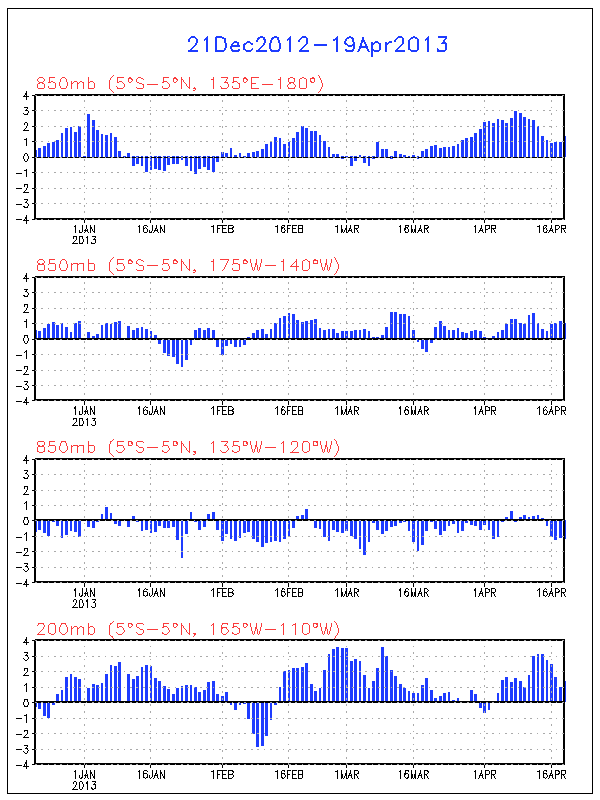
There is one leading indicator, however, which provides some predictive power – the Trade Winds just to the West of the Nino area. These Winds are, most often, concurrent with the Nino region Trade Winds but occasionally, they provide a ramp-up which might kickstart the ENSO. The West Trade Winds were a leading indicator of the Super El Ninos of 1982-83 and 1997-98 for example.

Click for a larger image
Unfortunately, I don’t know what drives these Western Trade Winds either, but they are currently pointing to a strengthening of the La Nina conditions which currently exist.
I also wanted to show more closely how the ENSO impacts global temperatures.
The warm or cold ocean conditions of the ENSO eventually impact the Tropics troposphere temperatures and this seems to be quite a direct impact with a lag of 2 to 3 months.

Click for a larger image
The Tropics temperatures then propagate out to the rest of the world with a small lag that may be up to 1 month but is more commonly concurrent with the Tropics anomalies.

Click for a larger image
The Trade Winds drive the ENSO, and the ENSO directly impacts the Tropics temperatures and the Global temperatures.
Who would have thought that Winds in some small region of the Globe could be so important. You can keep track of these Trade Winds on a daily basis at the Climate Prediction Centre.
http://www.cpc.ncep.noaa.gov/products/precip/CWlink/daily_ao_index/zw/zw.obs.gif
So, I think that provides a nice perspective on the ENSO.
The data used in this post can be obtained here.
http://www.cpc.ncep.noaa.gov/data/indices/
http://www.cpc.ncep.noaa.gov/data/indices/sstoi.indices
Bill, that is just eye candy to this weather nut. I wonder if these winds are set up by Earth rotation? Would the Terra firma spin faster than the atmosphere at the equator, thus making it seem like the wind is blowing from East to West instead of West to East in concert with Earth’s rotation direction? And then maybe viscosity of the atmosphere makes the trade winds strong or weak?
I wonder if trade winds are effected in fact by airborne particles.
http://qcl.farmonline.com.au/news/nationalrural/agribusiness-and-general/finance/global-warming-not-to-blame-for-drought/82765.aspx
Keith Potts has contended a close correlation which may be worthy of follow up.
Thanks Bill. You make it beautifully clear.
It would be interesting to know that the ENSO contribution to the global anomaly is. The billion dollar question is: What number of El Nino degrees C were part of the 1998 peak. If the models didn’t include this, then they would have concluded that too much of the warming was man made.
Of course the trade winds are driven by the rotation of the earth.
They may vary in their intensity and exact position but as long as the earth spins they will continue to blow.
They also drive the great surface ocean currents such as the Gulf Stream: which is why ideas that these currents could stop due to changes in water temperature is absurd.
Kindest Regards
“Who would have thought that Winds in some small region of the Globe could be so important.”
M. Ghil et al. / Physica D 237 (2008) 2111–2126
Climate dynamics and fluid mechanics: Natural variability
and related uncertainties
Abstract
The purpose of this review-and-research paper is twofold: (i) to review the role played in climate dynamics by fluid-dynamical models; and (ii) to contribute to the understanding and reduction of the uncertainties in future climate-change projections. To illustrate the first point, we review recent theoretical advances in studying the wind-driven circulation of the oceans. In doing so, we concentrate on the large-scale, wind-driven flow of the mid-latitude oceans, which is dominated by the presence of a larger, anticyclonic and a smaller, cyclonic gyre. The two gyres share the eastward extension of western boundary currents, such as the Gulf Stream or Kuroshio, and are induced by the shear in the winds that cross
the respective ocean basins. The boundary currents and eastward jets carry substantial amounts of heat and momentum, and thus contribute in a
crucial way to Earth’s climate, and to changes therein.
Changes in this double-gyre circulation occur from year to year and decade to decade. We study this low-frequency variability of the winddriven, double-gyre circulation in mid-latitude ocean basins, via the bifurcation sequence that leads from steady states through periodic solutions and on to the chaotic, irregular flows documented in the observations. This sequence involves local, pitchfork and Hopf bifurcations, as well as global, homoclinic ones.
The natural climate variability induced by the low-frequency variability of the ocean circulation is but one of the causes of uncertainties in climate projections. The range of these uncertainties has barely decreased, or even increased, over the last three decades. Another major cause of such uncertainties could reside in the structural instability – in the classical, topological sense – of the equations governing climate dynamics, including but not restricted to those of atmospheric and ocean dynamics.
We propose a novel approach to understand, and possibly reduce, these uncertainties, based on the concepts and methods of random dynamical
systems theory. The idea is to compare the climate simulations of distinct general circulation models (GCMs) used in climate projections, by applying stochastic-conjugacy methods and thus perform a stochastic classification of GCM families. This approach is particularly appropriate given recent interest in stochastic parametrization of subgrid-scale processes in GCMs.
As a very first step in this direction, we study the behavior of the Arnol’d family of circle maps in the presence of noise. The maps’ fine-grained resonant landscape is smoothed by the noise, thus permitting their coarse-grained classification.”
This is a very important paper in terms of our understanding of atmospheric -ocean circulation coupling.IE it increases our understanding of the fluctuation theorem.
The winds apparently affect the earths rotation, so I’m not so sure the rotation causes the winds…?
http://www.nasa.gov/centers/goddard/news/topstory/2003/0210rotation.html
Pamela,
The E to W direction of the dominant winds near the equator is a result of the coriolis force, a component of Earth’s gravitation, which is indeed due to the planet’s rotation. The coriolis effect makes large moving masses of air deviate to the right in the northern hemisphere and to the left in the southern hemisphere. Air moves from the tropics toward the equator to replace the hot air ascending over the latter. On their way to the south and the north, the coriolis effect makes the air masses deviate to the right and the left in the northern and southern hemispheres respectively, hence the north-easterly and south-easterly trade winds. Near the equator, these masses meet along an east-to-west course. Over the equator itself, there is a belt of unstable air with little wind; these are the so-called doldrums where sailships could get caught up in windless air for long periods at a time. The coriolis effect is also responsible for setting up the rotation in developing cyclones (anticlockwise in the northern hemisphere, clockwise in the south).
Bill,
Great stuff. I had often wondered about the band of contra-rotating vortices one sees develop over the equator in the SST anomaly plots, as in the animation you link to (particularly well-developed in the 12/29-31/2008 frames). These imply rather fast-moving (relatively speaking) masses of water, which might well be “driven” by stronger-than-average trade winds. This could be checked by comparing the strength of these vortices in the SST anomaly frames over time against the strength of the trade winds.
BTW
Compare your graphs of trade wind velocity above with the upper troposphere temperature graphs at http://discover.itsc.uah.edu/amsutemps/execute.csh?amsutemps. I checked quite a few years and it looks like there is a correlation between high velocity trade winds and colder upper air temperatures, and lower velocity trades with higher upper air temperatures. It once again looks like the sun is in control of these wind speeds and El Nino and La Nina. The colder air should result in higher pressures around 30 degrees latitude which should increase the strength of the trade winds.
another debunking of Steig’s paper at Lucia’s blog ?
http://rankexploits.com/musings/2009/steigs-antarctica-part-three-creative-mathemagic/
Interesting post….
It’s interesting that we now have had a prolonged period of +ve SOI.
This link will show SOI over the past 56 years
http://www.bom.gov.au/climate/current/soi2.shtml
The cool 70’s period is during the most positive phase of the recorded SOI. In fact this period was both cold & very wet down here in Australia. This also coincided with a weak solar cycle. It appears we are now looking at a possible extended +ve phase and once again we are in a weak solar sycle.
Surely this is just a coincidence !
Or: Both the ENSO and the tradewinds are driven by a third, as yet unidentified mechanism, and therefore vary in tandem … ?
http://en.wikipedia.org/wiki/Walker_circulation
“The Walker circulation is caused by the pressure gradient force that results from a high pressure system over the eastern Pacific ocean, and a low pressure system over Indonesia. When the Walker circulation weakens or reverses, an El Niño results, causing the ocean surface to be warmer than average, as upwelling of cold water occurs less or not at all. An especially strong Walker circulation causes a La Niña, resulting in cooler ocean temperatures due to increased upwelling.
A scientific study published in May 2006 in the journal Nature indicates that the Walker circulation has been slowing since the mid-19th Century. The authors argue that global warming is a likely causative factor in the weakening of the wind pattern.”
http://www.gfdl.noaa.gov/research/climate/highlights/PDF/GFDLhighlight_Vol1N3.pdf
http://www.nature.com/nature/journal/v441/n7089/abs/nature04744.html
I’ve tried to piece all these effects together, changing conditions of moisture, pressure, heat, wind patterns, and have come away with the impression that AGW modelers are out of their friggin gourds if they think they can predict future global conditions, especially such as a drier southwest US. And the “weather” right now, what with the jet stream way south and a weak lingering LaNina still haunting, one system after another dropping tons of precip on the SW, sure doesn’t appear to be fitting in with their projections.
Quick question (not ment as critique). Since correlation does not imply causality, could it not be the other way around? That the ENSO is driving the wind? From eyeballing the figures, it seems as if the trade winds are lagging the ENSO just slightly. Can I suggest that you do a phase analysis of the two signals? That should resolve the question.
Wrt the airborne particles theory posted by Howard, what comes first, the chicken or the egg ?
During strong El Nino periods we get drought in Northern Australia and Indonesia and therefore an increase in fires. This means we will likely see an increase in particle pollution as a consequence of the reduced trade wind.
Am I missing something with this idea ?
It sounds completely convincing to me. The lags etc. may indicate that the winds are the cause and ENSO is the effect – unless it’s the other way around, of course. Still, I would like to know why the trade winds oscillate in intensity. They may be “more elementary” than the temperature indices but they’re still not making things predictive.
Remember, coriolis does not imply causation, Andre. The consensus among climate scientists is that the earth’s temperature is retrospectively caused by the atmospheric CO2 concentration 800 years later (the Gore Effect).
What an intricate dance our earth is weaving through time and space. This is another beautiful piece of the puzzle you’ve given us, Bill — a potential explanation for what causes the ENSO phenomenon that seems to account for quite a big chunk of year-to-year temperature variation. Intriguingly, the trade winds may be the product of chaotic forces and as such inherently unpredicable. (The 1998 El Nino may even have been initiated by the fluttering , not of the wings of butterflies, but of the arms of all those concerned environmentalists at the 1992 Earth Summit in Rio.) And if that’s the case it will be pretty difficult to cap, trade or tax the source of that portion of the earth’s thermostat.
I think it is more likely that the tradewind and the ocean current have the same cause. The kinetic energy of the upper ten meters of ocean are the same as for the whole atmosphere above, and they only touch each other on one surface. Correct me if I am wrong.
How about comparing ENSO with the moons apogee and perigee and its position relative to the equator, together with aphelion and perihelion of earth?
If the moon in its perigee is north of the equator and in the apogee south, it would have e greater effect on the east2west currents and winds on the souhtern hemisphere. With the earth at aphelion at the same time, it would amplify this effect.
I can’t find data or a simulation program on the net for this, or what to look for. I only found that we are closest to the sun a few days after newyear.
Are the trade winds blowing clouds across the region preventing the sun from heating the water? If it is as you say that it is just mixing, then the heat still exists but is more spread out. If it is clouds blocking the sun light from warming the oceans, then that would explain the lost heat. Is there a correlation between the trade wind strength and the amount of cloud cover in the Nino area?
John M Reynolds
Some interesting stuff on the subject here
Annular Mode
A hemispheric-scale circulation pattern defined by changes in the westerly winds at midlatitudes. Those winds arise from the temperature contrast between the tropics and polar regions. The annular modes see-saw between positive and negative phases in what’s called a dipole pattern for weeks or months and take a circular shape (annular means ring-shaped). The two major types are the Northern Annular Mode (also called the Arctic Oscillation and strongly related to the North Atlantic Oscillation) and the Southern Annular Mode (also called the Antarctic Oscillation).
Circulation, Global
Energy from the Sun puts Earth’s atmosphere and oceans in motion. One reason is that solar radiation is not evenly distributed: the Sun hits the equator more directly than the poles, resulting in more heating in the tropics than at higher latitudes. In addition, the tilt on its axis that gives Earth its seasons results in a twice-yearly shift in the zone of maximum radiation: northward from December to June and southward from June to December.
Heated air rises above the tropics and flows toward the higher latitudes, where it cools, sinks, and flows back toward the tropics in an easterly (east to west) surface pattern known as the trade winds. This constant, overturning flow in the tropics is called the Hadley circulation.
Farther from the equator, Earth’s rotation combines with temperature contrasts between the tropics and polar regions to create midlatitude westerlies, along with cyclones and anticyclones, that move heat from the subtropics to higher latitudes. The warm fronts seen on weather maps are the leading edge of warm air pushing poleward, while cold fronts signal the flow of cold air toward the equator.
The oceans also redistribute heat via the thermohaline circulation, sometimes referred to as the ocean conveyor belt.
An introduction to atmospheric and ocean circulation, including explanations of pressure gradients and the Coriolis effect, for example, may be found on a University of Wisconsin Web site.
Kinetic energy is maybe the wrong term without talking about the same velocity of the two comparable masses, at the same time. … sorry
Hope you understand what i mean.
“The winds apparently affect the earths rotation, so I’m not so sure the rotation causes the winds…?
http://www.nasa.gov/centers/goddard/news/topstory/2003/0210rotation.html ”
The winds are created from high and low pressure cells, and that’s all caused from temperature differences related to the suns energy “influence” on the oceans/land and cyclical weather patterns. The only change for rotation is our bulging earth. Same rotation, just a bigger girth, adding one more second to our rotation this year( and more). Sea levels have been rising since the ice age, natural global warming the culprit.
It’s most ridicules to claim that AGW is now taking over for the SUN influences and when it comes to rises in seas levels (and temp). This has come to a stop or dropped for more then a few years.
Reason,
Expansion of our planet through planetary continental divide(seen on most planets) … of course caused by the sun/sun and planetary momentome magnetic forces.
Coupled with Bob Tisdale’s work on the links between El Nino and upward step changes in temp, and his work on the correlation of cloud cover and SST’s, we have a nice group of variables to play with. Toss GLAAM (Global Atmospheric Angular Momentum) into the mix, and it’s relationship with LOD (Length of Day) and the earth’s magnetic index, and we’re getting somewhere at last.
Really exciting stuff. Well done Bill Illis!
We reside in the suns atmosphere and solar radiation varies between sun cycle peaks and troughs. Does the suns gravitational pull on the earth vary between solar maximum and solar minimum, which in turn affects the earths gravitation which in turn affects trade winds?
So the water is hot… then the wind blows…. water cools…. less wind…. then the water heats….. then the wind blows….. sounds like a cycle to me…
let us add to this… the sun is 0.1C hotter the wind blows harder…. water cools faster…. wind stops fast…. even reverse… then the sun cools 0.1C….. water heats slower… the wind blows slowly not enough to cool water completely to stop wind…..
to heat water…. LIA?????? MWP????
Just my 2C
In electronics if we have two transmitters on at the same time, you can get “beats,or sidebands” of different frequencies. if we have sun cycle and add a geo thermal cycle there might be a sideband and or moments of both +/- here again mwp/lia?
Jeff ID? here is something to put into a regem mod. lol
NOOOOO!!!! it is CO2 driving weather!!!!! C+O2= IR2…… rolls eyes ! LOL
We’ve found that the upper ocean heat content is an even better leading indicator than trade winds. Check it out here:
http://www.cpc.ncep.noaa.gov/products/analysis_monitoring/ocean/weeklyenso/heat-last-year.gif