By P Gosselin
Fall Snow in Siberia
There is news from this part of Russia that often goes through the roof in the media. Forest fires or unusual summer temperatures come to mind. If only we had a speed limit in Germany, or at least installed more wind turbines, then it wouldn’t be so bad.
We have already recommended Ventusky several times here. The site visualizes weather data in an excellent way.
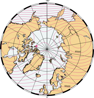
The snow cover can be displayed and there is interesting data from Siberia. The snow cover in mid-October 2024 is greater than it has been in recent years.
Ventusky himself believes it could have an impact on the winter weather in Europe because such large areas are already covered in snow. A line was drawn at the westernmost boundary in 2024, so you can see what the extent has been in recent years.

Screenshot Ventusky
It is likely that this anomaly will not reach the media. Yet it is good evidence of more moisture in the atmosphere. But one that can also have an effect on the weather and temperatures in the opposite direction. But that doesn’t induce clicks so well.
“Ventusky himself believes it could have an impact on the winter weather in Europe because such large areas are already covered in snow.”
Maybe, although Siberian air masses tend to head over to Alaska and Western Canada, plus Europe’s winter is heavily influenced by the NAO and Arctic Oscillation. We’ll see.
The reason he thinks that is because previous statistical analysis suggests a correlation. It’s not causal, it’s just more likely than not.
Still, all the alarmists will say -when the blizzrads will hit Scandinavia and western Europe – we did not see it coming. We believe in global warming! Because Globalist-Ursula has prompted us to say so!
The cold Siberian snow is CAUSED by global warming, the models are robust!
Anyone who knows anything about the Post Office Horizon scandal is extremely cautious whem robust software is involved.
No warming for decades.
PG claims a mid-October Siberia weather report could be a leading indicator of the upcoming winter weather in Europe. He presents zero evidence of any historical correlation PG usually writes much better articles than this one. Thos is a nothingburger.
Siberia Summer 2024
The global average temperature for the boreal summer (June–August) was the highest on record, and Europe’s average temperature was also the highest on record.
The average temperature of Europe is a stupid statistical construct.
Yes, there being hundreds (thousands?) of unique climates in different regions all around the world, each with their own behavioral and seasonal characteristics, anyone thinking that dodgy disparate temperature constructs from all of these climatic localities can be “averaged” into any sort of meaningful indicator of anything needs to quit their daily dosage of Kool-Aid.
One commenter on another blog even believes that altering temperature data into different formats affects the physical representation of the data itself.
Copy and paste is everyone’s enemy.
P. Gosselin copied what the editor(s) of KlimaNachrichten {Climate News} wrote. You need to take up the “zero evidence” claim elsewhere.
You don’t win a prize, but thanks for playing. 😏
And yet you provide your normal evidence-free bluster as a counter. .. YAWN !
I don’t see where he claims that. All he says is that it seems to indicate more moisture in the atmosphere and the snow cover could be interesting to consider.
Yep, too many variables at play to determine anything at all from this current Siberian snow cover. Certainly it might be worth considering if there were to be much more snow cover over Western Russia. A cold pool over this area (W Russia) at this stage in the winter can certainly influence the weather further west into Europe. But, we’re much more at the mercy of the Atlantic out here on the western edge of Europe. Also, if we do see Scandinavian blocking, we need Western Russia and the Baltic to be cold before we can expect any of the fabled “Beast from the East”. While it is mildly interesting that Siberian snow cover is more extensive this Autumn, I’ll only really start considering its impact on the winter if or when it extends much further west. Even then, the synoptics would need to be favourable, and this will only be achieved if the Atlantic doesn’t have its usual steamroller effect.
Much more likely that because of developing La Nina, we’ll see a colder than average NE of N America. This combined with warmer than average N Atlantic will drive a powerful jet stream east/ north east across into NW Europe. This powerful jet will usually mean a milder than average NW Europe. Even with powerful SSW events, a powerful N Atlantic jet can steam roller everything else. Meanwhile, the distant Siberian snow cover, would have little or no impact further west.
You can get a very cold Poland/Germany/Austria/Switzerland and a very mild Scotland/Norway in the same winter, you know.
This of course is true 🙂
It’s weather for goodness sake. Five years or ten or twenty.
Yellowstone National Park has had it’s first snow of the season. I think the second half of October is about average.
Last year was heavy precipitation (El Nino) year for the western US. This year is heavy precipitation for Siberia … are these events tied?
North America are getting early heavy snowfall. Sorry Mr Gore.
Really there isn’t sufficient evidence that anything unusual is developing thus this speculation is premature.
Weather varies every year thus the variations seen year by year is understandable as the atmospheric conditions that generate weather events are variable.
There is actually sufficient evidence that La Ninã is developing and this does often have the affect on the NE of North America I described earlier. As far as the main article is concerned however, I do agree that this doesn’t amount to much at this stage. Only in as much as extensive Siberian snow cover can in turn affect other atmospheric processes, does this situation present any possible affect further down the line into the winter.
There is an observed correlation here:
https://www.severe-weather.eu/global-weather/polar-vortex-winter-weather-pattern-forecast-snow-cover-anomaly-influence-united-states-canada-europe-fa/
“Weather patterns can influence the Polar Siberia. Multiple studies have proved that the snow cover extent in October over Siberia weakens the stratospheric Polar Vortex at a later period.
You can see a simple month-by-month diagram below, indicating the timeline of how a high snow cover over Siberia impacts the stratospheric Polar Vortex in winter.
A stronger winter high-pressure system can develop over the region due to snow cover. Then, this stronger high-pressure area affects the Polar Vortex, as it helps to send more vertical energy up into the Stratosphere.
A weaker Polar Vortex naturally means weaker polar circulation and a greater chance of cold air outbreaks over the United States and Europe during Winter. Below, you can see the basic schematic of the changing Polar Vortex circulation in an even simpler way.”
Very interesting. This is the potential effect on the PV. However, as noted earlier, even with total PV collapse, a warm N Atlantic can very quickly steamroller any cold outbreaks that might filter down to the UK in particular. Central, E and N Europe however may well be affected more broadly and for a longer duration by PV collapse. In recent years, the rather weak to medium stratospheric warming events we’ve seen have definitely affected mainland Europe more than the UK. More often than not the colder air being unlocked from the PV would be deflected south east from the Pole, through Scandinavia, then eventually pivoting west once it reaches E Europe, finally filtering into central and sometimes even W mainland Europe…..strategically missing the UK🤗
See my reply above
I think inner continental regions are always more likely to receive a direct hit from unlocked PV cold air masses….. famously the Central and Southern USA.
Agreed:
There really needs to be an eastern-based -veNAO/-veAO develop with an anticyclone stretching from Iceland to Scandinavia, such that NE to Easterly winds blow over the N Sea creating “lake effect” snow showers (if the air is cold enough – early season the NS SSTs are still quite warm). Often the high moves west into Greenland/Canada allowing the south-based PJS to bring in warm air from the SW – that set up brings frontal snow, and if the cold air pushes back, some spectacular falls in the south of England.
Meant as a reply to Neutral1966.
I don’t like rooting for cold to prove warming wrong… it’s easier to just say “I hope they’re right” and ask for plastic bags in the grocery line,
Also.. there’s the issue of temperature vs precipitation.
Alaska and western Canada are more exposed to air from Siberia, and with La Niña, the Great Lakes region.

In November, La Niña should be fully developed.
A weakening of the polar vortex is evident in the lower stratosphere, where two vortex centers have already formed in line with the two centers of the geomagnetic field to the north.

By way of update: Siberian snow cover has now dropped back to average and likely to stay that way until month end at least. Dr Judah Cohen, in his Polar Vortex forecast was also getting quite excited about the extent of Siberian snow cover but has now conceded that, with it falling back so quickly, he now doesn’t anticipate any outstanding disruption to the PV.
However, due to slow sea ice recovery, he is mildly supporting the idea of northern blocking over Greenland and Barents Sea, with a weak signal for colder outbreaks for Western Europe. Unfortunately, his earlier enthusiasm for a much more widespread colder N Hemisphere has now vanished.