To learn how ocean water is melting glaciers, NASA’s Oceans Melting Greenland mission extensively surveyed the coastline of the world’s largest island.
The most important thing to remember about NASA’s Oceans Melting Greenland mission, which ended Dec. 31, 2021, may be its name: OMG proved that ocean water is melting Greenland’s glaciers at least as much as warm air is melting them from above. Because ice loss from Greenland’s ice sheet currently contributes more to the global rise of the oceans than any other single source, this finding has revolutionized scientists’ understanding of the pace of sea level rise in the coming decades.
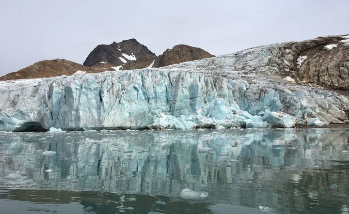
These new, unique measurements have clarified the likely progress of future ice loss in a place where glaciers are melting six or seven times faster today than they were only 25 years ago. If all of Greenland’s ice sheet were to melt, global sea levels would rise by about 24 feet (7.4 meters).
But that’s just the tip of the iceberg in the story of this small plane- and boat-based mission. In six years of operations, OMG made the first scientific measurements along many miles of the most remote coastline in the Northern Hemisphere. The mission performed the most complete survey of the seafloor around Greenland’s coastline, including dozens of previously uncharted fjords (cliff-lined inlets clogged with icebergs from disintegrating glaciers), and measured how the ocean temperature changed from place to place, year to year, and top to bottom. To get this unique dataset, mission planes logged enough air miles around and over Greenland to circle the globe more than 13 times.
Preparation
More than 220 glaciers flow from Greenland into the ocean. Before OMG, scientists figured the ocean water swirling around and under these glaciers had to be contributing to their ice loss. But how much?
Satellite observations of sea surface temperature weren’t much help in answering that question. Around Greenland, the top layer of the ocean is extremely cold and not very salty, containing a lot of water from the Arctic, the freshest of oceans. A shallow glacier that only touches this layer melts slowly. But hundreds of feet below, the ocean is warmer and saltier. A deep-seated glacier is eaten away by the warmer water, losing ice four or five times as fast as a shallow one.
The only way to find out any glacier’s risk is to go to Greenland and measure the glacier and the seafloor and water in front of it. Scientists had been studying individual glaciers that way for years, but Josh Willis, principal investigator of OMG at NASA’s Jet Propulsion Laboratory in Southern California, wanted to get the complete picture: to measure all 220-plus glaciers for five years – the length of time available to missions funded by NASA’s Earth Ventures airborne research program.
“When we started to design OMG, we asked ourselves, ‘Can we do an experiment in five years that will tell us about the next 50?’” Willis said. Results have proved that they could. NASA even allowed them a sixth year of fieldwork to observe unexpected, rapid swings in water temperatures off Greenland’s west coast.
Operation
The mission’s first job was to map the seafloor around the island to see where deep, warm water can reach glaciers. A contractor completed most of the mapping using a research boat, and OMG Deputy Principal Investigator Eric Rignot of JPL and the University of California, Irvine led smaller surveys in following years to fill in missing sections.
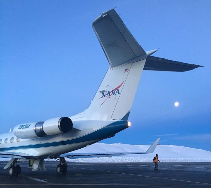
To measure the ocean temperature and salinity down to the seafloor, Willis ran a summer airborne campaign that dropped about 250 probes each year into the ocean at strategic locations around the entire coastline. Six summers of flying over the remote Arctic may sound more like an adventure than a research project, but, Willis said, “It’s only an adventure in retrospect. While you’re in it, you have your head down and you’re working as hard as you can.” For the scientists, the data streaming into their computer from the probes was excitement enough.
The detailed maps and temperature data collected by OMG show that two to four times as many glaciers sit in water that is several degrees warmer than previously thought and, thus, are at higher risk than anyone knew. Researchers understood that about a third of Greenland’s glaciers account for half of its ice loss; OMG found that all of these culprits reach down into warm water. Climate models that don’t account for the warm water’s effects underestimate glacial ice loss by at least a factor of two – in other words, missing half the sea level rise from this source.
Collaboration
OMG’s groundbreaking data has influenced many kinds of Arctic studies besides oceanography. For example, Kristin Laidre of the University of Washington is an internationally known expert on narwhals, Arctic whales with a tusk-like protruding tooth. She and Ian Fenty, an OMG co-principal investigator at JPL, developed a project that benefits both marine biologists and oceanographers: a research cruise to place OMG probes and acoustic sounders that record the presence of narwhals in front of West Greenland glaciers.
The probe data provides a close-up view of how much ocean conditions can vary in a small area, and Laidre hopes that, in combination with the sounder data, it will help explain why certain glacier fronts are especially attractive to narwhals. “We biologists can get a better understanding of animals and populations by working with physical scientists,” she said, referring to the OMG team. “To have a group of scientists who want to collaborate is really great.”
Continuation
The end of the mission doesn’t mean the end of all new data from the Greenland ocean. In 2021, the team dropped a few longer-lived probes in areas where changes in ocean temperatures or circulation are not fully understood. These probes “winter over” below the surface, continuing to bob up and down through the water to collect data that will be read remotely when the ice melts next summer.
And scientists in many fields will continue to draw on OMG’s observations for their research. To date, about half of peer-reviewed journal articles using the data are written by researchers outside the mission’s science team – an unusually large portion. “We’re seeing a lot more science than we originally planned,” Willis said. “Those papers aren’t going to stop.”
Jane J. Lee / Andrew Wang
Jet Propulsion Laboratory, Pasadena, Calif.
I am all for objective study but the conclusions should be based on the data not speculation.
“OMG found that all of these culprits reach down into warm water. Climate models that don’t account for the warm water’s effects underestimate glacial ice loss by at least a factor of two – in other words, missing half the sea level rise from this source.”
What they are calling warm water is likely what most people would call slightly less feezing water. That aside, finding there may be more melting of coastal glaciers due to exposure to sea water does not automatically translate into increased sea level rise. This is only one end of the glacier and at the other show and ice are accumulating from precipitation. It is the balance of the two that determine contribution to sea level rise. Warmer oceans will in theory support increased evaporation and precipitation leading to increased snow and ice deposited in glaciers. The more energy in the ocean/atmosphere system the greater the water transport. I am sure the authors of the article know this and the omission of that fact seems intentional so that an alarming narrative can be birthed yet again based only on speculation and models.
This would be only one of multiple deficiencies of climate models which are well preventing to be useless about predicting future climate and all the impacts of that.
Sorry “we’ll proven” not “well preventing”
Indeed.
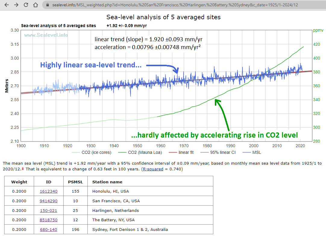
Most climate alarmists think warmer temperatures necessarily cause melting, and thus accelerate ice mass loss from glaciers and ice sheets, and thus necessarily accelerate sea-level rise. They build those assumptions into the models which predict catastrophic sea-level rise, and they have a hard time believing the measurement data which shows very little acceleration in global sea-level rise in response to rising CO2 levels and global warming:
https://sealevel.info/MSL_weighted.php?id=Honolulu,%20San%20Francisco,%20Harlingen,%20Battery,%20Sydney&c_date=1925/1-2024/12
A warming climate doesn’t necessarily cause melting. For example, Antarctica averages more than 40° below zero. I hope it is obvious that a few degrees of warming cannot melt it!
Of course warming does cause melting, in some places, in the right circumstances. But the most important factor affecting annual changes in ice mass, for the Greenland and Antarctic ice sheets, is NOT melting. Nor is it iceberg calving, nor sublimation.
The most important factor affecting the annual ice mass balance of ice sheets and glaciers is snowfall.
Snowfall is the most important factor affecting net ice mass flux for both the Greenland and Antarctic ice sheets, and snowfall was also certainly a very important factor affecting the advance and retreat of the great Laurentide, Fennoscandian & Cordilleran ice sheets, 8K to 14K years ago.
A warming climate accelerates snowfall accumulation on ice sheets and glaciers, through two distinct mechanisms:
#1. Warmer air carries more moisture. Below freezing, it’s 8-12% more moisture per 1°C of warming. (That’s why heaviest blizzards occur when temperatures are only moderately below freezing.)
● https://web.archive.org/web/20190928155425/https://web.gccaz.edu/~lnewman/gph111/topic_units/labs_all/water%20vapor%20capacity%20of%20air.pdf
● https://www.google.com/search?q=%22too+cold+to+snow%22
#2. Reduced sea ice coverage = more open water, increasing ocean evaporation and thus “lake/ocean-effect snowfall” (LOES) on downwind land.
● http://archive.is/vp9eP#selection-1257.0-1257.450
● https://google.com/search?q=%22lake%2Focean-effect+snowfall%22
The importance of LOES is illustrated by the story of Glacier Girl, a P-38 warbird which made a forced landing on the Greenland Ice Sheet during WWII. It was buried by snowfall which averaged ≈70 feet/yr (no, that’s not a typo!), and recovered 50 years later.
That snow represents evaporated water, mostly removed from the North Atlantic and Arctic Oceans, which then fell as ocean-effect snow on the Greenland Ice Sheet.
The story of Glacier Girl is fascinating. You can read more about it here:
● https://www.airspacemag.com/history-of-flight/glacier-girl-the-back-story-19218360/?all
● https://p38assn.org/glaciergirl/recovery.htm
The near-linearity of sea-level trends over then last nine decades, despite a warming climate, prove that accelerations in ice mass loss in some places are being roughly balanced by accelerations in ice mass gain in others, through increased snowfall accumulation. Here’s a list of a half-dozen papers (and a few articles), published over a span of about thirty years, about accelerating snowfall accumulation in Antarctica:
https://sealevel.info/feedbacks.html#antarcticsnowcitations
It is remarkable how slow the climate modelers sometimes are to incorporate the influence of measured reality into their models. It took about thirty years (counting from this 1991 paper) for the modelers to discover that warmer temperatures increase snowfall accumulation on Antarctic ice sheets, largely offsetting ice loss from melting and iceberg calving, and to incorporate that fact into their “new generation of climate models.”
Let’s say that all of Greenland’s ice melts, and all that water goes into the oceans. What happens to the land mass of Greenland? Right now it’s held below sea level from the weight of the ice, so it will rebound. But then, if all the ice melts and puts that weight into the oceans, then the ocean floors will sink. Maybe the continents will rise as well to match, so how can we be sure that the sea level will actually rise to match the volume of water released into the ocean? After all, if Greenland is floating on the mantle and rebounds, there’s gotta be some volume of the mantle that flows in to fill that void, and with the extra weight of water, the additional volume would likely be created by a sinking sea floor.
And once again arctic sea ice is at the second highest level it has been in the last 19 years.
Does this seem circular AND false-to-fact to anyone else? I should think that anyone would need at least some part of 50 years of observation to be able to claim any result from a five year experiment. Is a model really an experiment?
The fundamental premise that this research is based on is wrong. Oceans cannot be warmed by increasing surface radiation. Increased surface energy uptake simply accelerates evaporation and upwelling. The upwelling water comes from a very cold place typically at 2C.
Hence increased surface radiation cools the oceans. Oceans have warmed because they are getting less sunlight and the net water cycle has slowed down. In the present era the net water cycle is near its minimum. Over the next millennium, it will accelerate again, particularly during boreal winter, increasing precipitation on northern land masses.
Science advances.
Or maybe not.
Climate models need to know/model glaciers melt? Apparently, they are not really climate models.
First they assume they know all of the sources for sea level change… Then the first one they examine is melting twice as fast…
What’re they going to do? Increase sea level rise to match their absurd assumptions?
One of the authors is involved in earlier controversial adjustments to the data from early Argo floats. Rejected data that was colder than preconception, was the allegation.
Proper, hard science tends not to attract adjustment or preconception criticism. Geoff S
The other elephant in the room is the bottom melting due to magma plume heating. This is evidenced by the sinking of Camp Century and the WWII fighter airplanes. The latter are now down about 350 feet, and they are nowhere near the ice cap edge, where gravity flow would influence ice levels.