from the NoTricksZone
By Kenneth Richard on 18. November 2021
Despite sea level rise, 1984-2019 satellite data show coastlines have been globally expanding by a net +0.26 m/year.
A new study affirms what satellite data have been telling us for years: “the global coastline is prograding” (Mao et al., 2021).

Growing islands, beaches, coasts “all over the world”
This isn’t the first time shoreline expansion in the era of global warming and allegedly rapid sea level rise has been documented.
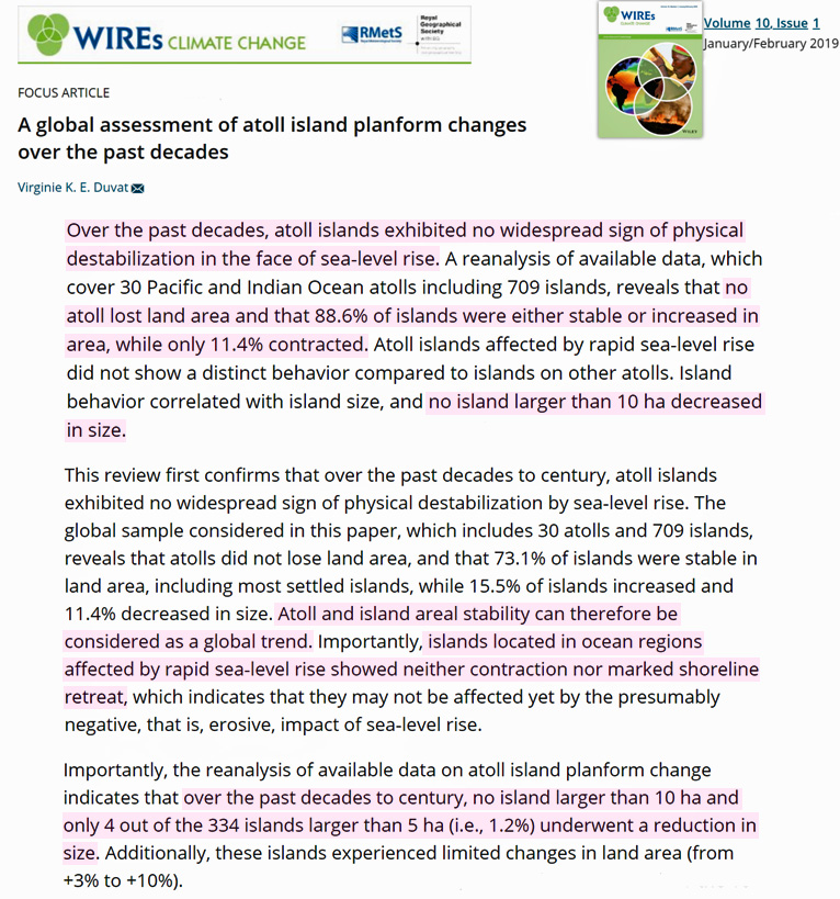
A 2019 global-scale analysis of 709 islands in the Pacific and Indian Oceans revealed 89% were either stable or growing in size, and that no island larger than 10 ha (and only 1.2% of islands larger than 5 ha) had decreased in size since the 1980s (Duvat, 2019).
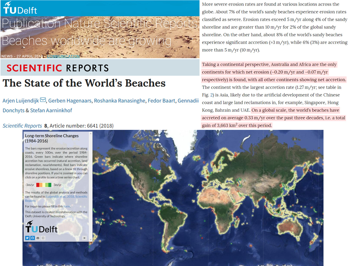
Likewise, the globe’s beaches been growing by 0.33 m/year since 1984 (Luijendijk et al., 2018).
In a press release for a 2016 paper on coastal land area changes from 1985 to 2015, scientists acknowledged this:
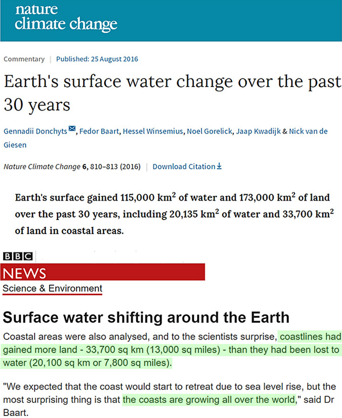
“We expected that the coast would start to retreat due to sea level rise, but the most surprising thing is that the coasts are growing all over the world“ – BBC
“Accretion is the dominant trend…across the world”
Today there are high resolution satellite images available from Google Earth clearly demarcating global-scale decadal shoreline change since the 1980s.
According to Mao and colleagues, Australia’s coasts have been growing at a rate of +0.10 m/year. Asia’s coasts have been expanding +0.64 m/year. Europe’s coasts are accreting +0.45 m/year. And the African continent has been observed expanding at a +0.31 m/year clip since 1984.
The only two continents where coasts have not been observed expanding in recent decades are South America, 0.00 m/year, and North America, -0.29 m/year.
Claims of dangerously accelerating sea level rise posing an imminent global threat to coasts have once again been challenged by real-world observational evidence.
Mao is a rather unfortunate last name for anyone in the West who intends to be a public figure. Perhaps Yongjing might want to consider some sort of modification.
Tuvalu water stunt is totally bogus and shameless pandering for more CACA bucks.
Mao is a rather unfortunate last name
There once was a time when that was actually true.
Just remember that in Chinese names the family (“surname”) comes first, with personal names after. (Sorry about the pedantry)
Not necessarily (alas!). Respecting and never criticising Emperor Xi of the PRC, who sees himself as the new Mao, is part and parcel of the alarmist movement who would much rather destroy their own part of the world instead of even politely asking Xi to change anything in his country. With this kind of reverence prevalent, the mere name of Mao really should give _any_ message a bit of extra weight!
Good study with real data
NA land is stored in landfills.
Real-world observational evidence is always so much more interesting, challenging, factual, and informative than endless computer-generated graphs and spreadsheets.
This particular “observational evidence” has big holes in it. In particular, the width of the scanning radar pulse is kilometers wide from satellite distance. Resolving it statistically to .1 meter as the author seems to claim is a complete fantasy. A tight beam looking at a metal target from 2 miles away is needed to succeed at that…So junk science….
It says it used surface reflectance imagery not radar
It is unfortunate that the NoTricksZone author of the above-cited article did not make it very clear that the “coastline expansion” was in the horizontal direction only . . . without any vertical component . . . since the article’s title referred to “sea level alarmism”.
A good editor would likely have caught and corrected this oversight, but alas, c’est la vie.
Gordon, not sure I understand. The rise in sea level is generally cited as one of the dangers posed to human development along side the oceans. If land is expanding out, that seems to be lie any concerns about encroachment from the seas.
Well … I can imagine what Gordon’s point is: the article has no information about how much vertical deepening occurred at the oceans bottom. It is the only way to demonstrate that the sea level is rising in spite of the horizontal spreading of the emerged land … I think that such explanation would very well fit into a redefinition of the concept of “sea level rising”: sea level can rise and become apparently lower. A kind of what happens with global warming causing global lowering of temperature (you know, temperature and warming are completelly different things, they are independent from ech other and so they can vary in opposite directions… but I digress!).
The sea level is supposedly rising how does the land increase if it isn’t higher than the rising sea. The expansion process HAS TO BE KEEPING UP WITH SEA LEVEL CHANGE BY DEFINITION.
Natural sedimentation with the help of wave action.
Dave,
Please look at the graphic map in the above article . . . land is not always expanding out (the green coloration on the map), there are quite a number of contracting shorelines (the red coloration on the map).
I think those people living in or near the red areas need to stay concerned about encroachment from the seas.
But that was always true for coast lines. Some expand, some retract. Nothing unseen before there.
I actually wonder of the net gain is coming from humans actively preventing encroachment thereby generating an artificial human-made positive bias that easily offsets what sea level rise does.
So, I may be denser than your typical brick, but how does one expand out against the ocean, but not up at the same time? Is there some mysterious force that keeps water at bay, from overflowing this new expansion of the coastline?
Must be the same way the Netherlands expanded their usable land, just all over the world without actually building dams and dikes, but by magic!
Those unicorns at work again.
And as to “A good editor would likely have caught and corrected this oversight ” Yes a climate change gatekeeper editor would surely have caught that, and kept the paper from being published.
Its the Klimate Karens/Kevins new trick
Invent a new rule that immediately dismisses any physical data that contradicts the alarmists rising sea/ sinking land theories. “It doesnt matter “
Well, one way this happens is that the water (tides, waves, currents) washes more sand up onto the beach than it washes away from the beach. The level of the mainland does not rise, nor does the sea level fall. This seems to be the main effect on the expanding small atolls.
Too small for sand to move far , it’s actual acreation as the only source of coral sand is from the reef. Those parrot fish I understand cruch away at small pieces and spit it out as sand
“and spit it out as sand”
Well, nearly. As this is a family blog, perhaps we should leave the spelling as is!
Totally understand that. But if the sea level was changing, wouldn’t that mean the shoreline would also move in – unless the accretion of beach material was faster than the sea level is rising, which means that the net effect is no sea level change?
Please see my additional post below for an answer to your question.
When a coastline expands 3 inches, go back 3 inches inland from the new border. That spot has some vertical gain. Or not. Can you figure a way that did not expand vertically?
I’ll take a crack at it. That would happen if the sea level were falling.
See Harlech castle sea gate.
Bingo. We have a winner!
Ragnar.
What happens is that the hinterland is lowered as the shoreline increases. Think of a pile of sand being washed by the sea.
Coasts all over the world are either rising or sinking, often due to Isostatic equilibrium.
During last glaciation, where land ice was thick, land sunk and is now rising again. This mainly occurs in higher northern latitudes.
Where glacial ice did not cover, and because a continental mass can act like a stiff board, land rose earlier, but is now sinking because ice moved back to the oceans. This occurs in southern North America.
Half of the rise in sea level around Chesapeake Bay is due to sinking costal land.
Always wondered how the Greenland Glaciers persisted and expanded through the end of the last glacial era into the present day interglacial while the North American glaciers melted away. One would think the same insolation process that melted the NA glaciers would have effected a similar change in Greenland.
The Greenland ice sheet is more or less hemmed in between two mountain ridges. The orographic precipitation that occurs adds more ice/snow than can melt away in summer. The glacial sheet mass losses that do occur are mostly due to glacial floes and calving not direct melting.
More than half.
Gordon Gordon Gordon are you really that stupid. If the expansion was only horizontal then shouldn’t it be exactly at the water level and the beaches getting shallower and the land less as the water is rising according to you. What I am trying to get you to think about is the stupidity of your statement. IF THE WATER IS RISING AS YOU CLAIM the only way the land can expand is to be higher than the rising water.
LdB, LdB, LdB,
I duly note your ad hominem attack . . . and note the quality of its source.
To wit: regarding your last sentence, please point out, specifically, where I ever claimed, or even implied, “the water is rising”.
LdB,
Still waiting on my request to you . . . but now not really expecting anything.
You see, the logical fallacy of a strawman argument is so sophomoric, so easily spotted, and so easily refuted that most commenters here at WUWT know better than to use it.
When someone is called out for such, the usual response is silence . . . just as in this case.
From the number of dislikes I’ve received, I obviously need to explain my previously posted comment better.
Here goes:
If a “coastline” is expanding HORIZONTALLY (as seen from airplanes or from satellites), this has THREE separate interpretations: (a) it could mean that coastland is actually being newly formed (accreted) faster than the local sea level is rising, such as commonly occurs in coral atolls, or (b) that land is being uncovered from previously being under water due to local seashore uplift being faster than the local sea level is rising, or (c) that the local sea level is actually falling, not rising, and at a rate faster than any seashore subsidence that might be occurring.
Hence, the observation of “coastal expansion”, without more exact definition (specifically, the vertical component of “coastal expansion”), is ambiguous as to telling us how absolute, or even relative, sea-level is changing adjacent to such “expansion”. That’s the basic reason for my previous post.
The relative rate of change of sea varies significantly around the world, even going negative in some places and over some durations,
A good explanation of why there can be large temporal and spatial variations in “mean sea level” across Earth’s oceans can be found at
https://www.e-education.psu.edu/geog862/node/1820
From that linked article:
“So, while there is a relationship between Mean Sea Level and the geoid, they are not the same. They could be the same if the oceans of the world could be utterly still, completely free of currents, tides, friction, variations in temperature, and all other physical forces, except gravity. However, these unavoidable forces actually cause Mean Sea Level to deviate up to 1, even 2, meters from the geoid.”
Oh, a fourth factor to consider in how “costal expansion” can be occurring, with a tip-of-the-hat to certain commenters below (and embarrassment on my part for having overlooked this now-obvious certain mechanism):
(d) the erosion of rocks and soils from inland highlands being transported down to the seashore, such as occurs in the “coastal expansion” of the Mississippi River delta and the Nile River delta. Then, too, there is the low-lying State of Florida . . . “As the Appalachian Mountains eroded, sand and clay were deposited over Florida’s limestone layer. Much of the quartz sand covering the state today came from the rocks of that mountain chain.”— source: https://fcit.usf.edu/florida/lessons/land/land.htm
So your answer A,B,C and D all give vertical movements and there are more but lets go back to your stupid opening statement
They don’t need to talk about the vertical because it is IMPLICIT to anyone with half a brain. They don’t measure the land movement because if your read the paper the technique doesn’t allow it. You got all the down votes because your post was stupid.
Op. cit.
And would that be vertical upwards, or vertical downwards . . . being so implicit, that is?
Now, you were saying something about “stupid” . . .
Right so vertical downwards below sea level would expose more land mass … yeah sums you up .. you certainly earnt your down votes.
I think we are done here don’t you.
Isn’t it obvious, as I previously posted, that shoreline subsidence (i.e., vertical downward decrease) would still reveal more shoreline . . . an expanding shoreline . . . as long as the rate of local sea level decrease was greater.
Mathematics can be your friend.
Sure, I’m done . . . it was enjoyable up to the point of your ad hominem attacks.
No, it’s totally obvious. A downward would flood more.
Seriously, this is really easy. If there’s no vertical change in the land/shoreline (relative, local, global – doesn’t matter), then there CANNOT BE any horizontal change.
The ONLY way the shoreline moves out is that the land ends up higher than the water. Don’t care HOW it happens – but it has to happen, otherwise it doesn’t work.
Fantastical theories notwithstanding.
Hence my OP criticism that the above article needed reference to what was happening vertically in those areas identified as both “expanding coastline” (called accretion in the article) and “contracting coastline” (called erosion in the article).
As I identified above, and as indicated be the large number of comments to my OP, without reference to what is happening in the vertical direction on both the coastline land and its adjacent sea level at any given location, a statement about just horizontal coastline “movement” will be very misleading.
I stand by my OP statement (with the underlined clarification noted here): “A good science-educated editor would likely have caught and corrected this oversight . . .”
Nope, you stated affirmatively that the land only had horizontal movement.
Nothing at all about the four possibilities you tried to later use to rescue your folly.
Gordon, sorry for nitpicking,
But you have left out the fifth factor, a very meaningful factor when it comes to the “vertical component”, especially.
The incredible uge uge number of Hiroshima(s) going non stop into the oceans.
Must already be depressing and sinking considerably the oceans bottom, and therefore affecting-effecting, whatever, the vertical component… at the very least…
till the dreaded time of overblowing and great inundation and global heat scorching comes.
As Dana will put it;
internal variability… not natural though, but still internal variability, although anthropogenic in this case.
well!
cheers
whiten,
I don’t mind nitpicking, except when it is far off-base and flat-out incorrect . . . which it is for your post.
To wit:
1) “The incredible uge uge number of Hiroshima(s) going non stop into the oceans.” Assuming you are referring to huge number of Hiroshima-size atomic bombs of equivalent energy being put into the world’s oceans, one hardly know where to begin with a reply, but I’ll try.
A quick Web search reveals that the fission bomb exploded over Hiroshima resulted in a energy release of about 15 kilotons of TNT (63 TJ)—source: https://en.wikipedia.org › wiki › Little_Boy
And for comparison, let’s just look at a small slice of the world’s oceans centered on the equator:
“During an average day, the 60 million square kilometers of surface waters of the tropical oceans (located approximately 10 degrees north to 10 degrees south of the equator) absorb one quadrillion megajoules of solar energy-equivalent . . .”— source: https://issues.org/avery-2/
Working out the math: a terra joule (TJ) is equivalent to 1 million megajoules, and one quadrillion (10^15) megajoules is equivalent to 1 billion million megajoules.
So, Hiroshima bomb = 63 TJ = 63 million megajoules.
Average daily solar energy absorbed in world’s oceans 10N to 10S = 1 billion million megajoules.
Let’s assume “1 million per day” would qualify as a “huge” number in the context of you post. In that case:
One million Hiroshima-size bombs per day = 63 million million megajoules,
versus
solar energy absorbed in world’s oceans 10N-10S per day = 1 billion million megajoules.
Therefore, your “huge number” (my estimate of 1 million per day) of Hiroshima-bomb equivalents of energy actually represents only
63 million/1 billion = .063 = about 6% of the daily solar energy input to just a fraction of the world’s oceans.
2) Note that solar energy input arrives from a external source, so “internal variability” and “anthropogenic” having no bearing with regard to this matter.
3) “Must already be depressing and sinking considerably the oceans bottom, and therefore affecting-effecting, whatever, the vertical component… at the very least…”
Energy input (in this case thermal input from solar radiation) does not create a unidirectional force . . . it only results in isotropic thermal expansion of ocean waters over the depth of absorption of sunlight. In additional, the absorbed thermal energy does NOT change the mass of the world’s oceans. Therefore, I’m at a complete loss to understand your reference to energy “depressing and sinking considerably the oceans bottom”.
4) Your phrase ” . . . till the dreaded time of overblowing and great inundation and global heat scorching comes” belongs in a Bible-study discussion, not a science-based discussion.
Nevertheless, cheers back at ya.
Gordon,
A good reply… at last… really good one.
Wish I could e-mail it to Nuccitelli.
The guy and his pals are really really worried about those Hiroshima(s).
thank you
cheers
True. Here’s one way the length of a coastline could increase while sea level rises: if the higher coastline were more jagged. Take for example a region made of boulders uphill from a sand beach. The sand beach is more or less straight (curved, for sure, but not jagged); if sea level rises so that the new coast line is in the boulders, then the length of coastline will be longer because the waterline goes back and forth around the boulders.
That’s a contrived example, which probably doesn’t make a gnat’s worth of difference in the real world. But it does show that length of coast and sea level do not necessarily march in synch.
Please read these books, the two best books debunking climate change crap. Click the links to download a free copy. Please share with your family and friends.
The moral case for fossil fuels
http://library.lol/main/95AC3FC1E1D3768A2FF58A9556284B4E
Fake Invisible Catastrophes and Threats of Doom
http://library.lol/main/62F19352A7FD8FA7830C90D187094289
Another brick in the AGW wall.
what did you dream/fear?
It’s alright we told you what to dream
With a lot of this remote sensing stuff, take it with a dose of salt. KR at NTZ tends to highlight stuff confirming his skeptical bias, as here. So I did some quick remotes sensing research on recent papers assessing horizontal spatial accuracy. Not good. The conclusions in the new Mao paper are shaky at best.
First resource, USGS.gov. They brag about their LIDAR and GPS coastal measurements from low flying aircraft. Accurate to about 0.5 meters, but very expensive. So they talk about their less accurate Landsat derived estimates. The newest LandSat bird is LS9, and per USGS their method has a spatial resolution of 15 meters!
Second resource RSE v229 pp260-270, 2019. Describes a new coastline extraction method from commercial satellite high resolution coastline images. The new algorithms resolve coastlines down to 2 meters.
Third resource Geoscience 5/2020 available at http://www.mdpi-Res.com. Corrected the GeoEye1 sat images (resolution 2 meters) for an Italian harbor using a low flying UAV. Got it down to 0.5 meter by essentially correcting via the USGS LIDAR/GPS method, achieving the same result as the ‘accurate but too expensive’ USGS primary US coastline method.
So I am NOT persuaded by Mao’s new paper’s conclusions. All are within the intrinsic uncertainty, proving nothing about coastal accretion or about SLR.
BTW, I live directly on the Atlantic coastline in Ford Lauderdale. I watch it changes with tides, storms, and the general southerly sand flow that requires beach replenishment every 20 years or so. Intrinsically uncertain coastline over time visible right off my east balcony, so am not surprised by these results—except for Mao’s poor paper.
Their have been separate studies of pacific atolls based on aerial photos which have found the same thing. Appreciable growth in land areas on most, declines on a few
They use field data as well
https://www.auckland.ac.nz/en/news/2020/11/30/low-lying-pacific-island-has-more-land-above-sea-level-than-in-1.html
This interesting instrument has a resolution of only 30 meters:
https://aqua-monitor.appspot.com/
In case of considerable sea-level rise, you would expect to see mostly drowned flat coasts – if anything visible. I was looking for them, but could not find such a pattern. Check for yourself: zoom in on known beaches or on places where you expect to find a certain pattern. Green is ‘Land Growth’ and blue is ‘New Water surface’ over the mentioned period.
Southeast of the Amazon river a mixed pattern of blue and green is visible. Northwest of the Amazon (where the North Equatorial Current transports most of the sediment to) the flat muddy coast most times shows growth. Human influence may be expected to be small or totally absent in both areas. Both areas also have the same predominant (northwest directed) sea current.
More info: https://www.deltares.nl/en/software/aqua-monitor/
Rud
You identified these wonderful sources of coastline remote detection data. But I think that you forgot to mention what these data sources actually turned up. What did they find? Expanding or contracting coastlines?
The papers found ‘nothing’ because of the resolution.
I’m no expert, but my take on the headline was that sea level is not rising. That’s not what the paper says. The accretion seems to be principally public works projects. The paper provides little that’s new to the issue of sea level changes
Jim,
Care to cite significant public works affecting the thousands of km along coastal northern Australia? Darwin, the only city, must be doing some heavy lifting! Geoff S
Nothing significant in the form of public works along the north and north-east coasts, just a small amount of sand replenishment where discharge from rivers has been inhibited by weirs, and a small amount of dredging. Last time I counted, there were about 43 tide gauges on the Queensland coast. They all tell a slightly different story and none are necessarily wrong. Australian plate is moving ~north at 70mm/yr. In front of my place, 19°11’25.58″S, 146°40’40.19″E, and the long-shore drift continues. Top of frontal dune is now a couple of metres beyond the line of pumice that was deposited from the Havre Seamount back in 2012.
Those red areas are erosion.
lee,
Yes, and those green areas are replenishment. The point is, no change of any significance is caused by the Hand of Man along the north Australian coastline.
Quite the feisty discussion. Note my disclaimer of expertise please. Of course, I did not say that the increased coast always and everywhere (Darwin??) was by virtue of public works. I was suggesting that the headline was not appropriate given that a lot of the increasing coast is by reclamation and not by failure of the seas to rise, as implied by the headline. A more appropriate headline, albeit more wordy, might be “There is much conflicting data on whether or not sea level is materially rising, but don’t worry as man’s ingenuity is finding ways to increase coastline faster than it is lost.”
Exactly, Jim H.
This stuff reblogged from the (No?)TricksZone shows that they stubbornly tried to distort an information having nothing to do with sea levels, and turned it into ‘no sea level rise’ aka ‘no warming’.
” Claims of dangerously accelerating sea level rise posing an imminent global threat to coasts have once again been challenged by real-world observational evidence. ”
This is simply ridiculous: sea level rise might very well become a problem, but certainly not before decades: actually, both satellite altimetry and global tide gauge data show for 1993-2020 around 3 mm/yr on average (it might of course be less or more depending on single locations).
Moreover, soil accretion on e.g. the Marshall Islands won’t help them much, because the accretion will extend the islands’ surfaces, but certainly not elevate them.
“Moreover, soil accretion on e.g. the Marshall Islands won’t help them much, because the accretion will extend the islands’ surfaces, but certainly not elevate them.”
How does that work out? If the surface extends despite simultaneous sea-level rise, it follows necessarily that the extended surface must be ABOVE the new, risen sea-level and therefore more elevated. A totally flat accretion would be reversed by the rising level of the water and not show as an actual extension at all. The fact that extension happens in step with, or even faster than, sea-level rise in so many places says not much about current, past, or future sea levels, but it proves that whatever the sea level has done so far has not eaten away noticeable areas of dry land (which is what the alarmists try to sell us as imminent and fatal danger), and is not likely to do so in future, as the land accretion processes will continue like before. Any calculation of land loss due to sea level rise that does not take the rather considerable and continuous natural accretion on many coastlines into account, is bound to be grossly overestimated. It looks more like erosion and flooding in some places are offset by accretion and build-up (yes, elevation!) in others, while the sum total of dry land stays the same in the long run. And since a salient characteristic of all living things is that they can MOVE from one place to another – some (e.g. most plants) not as individuals, but all of them as species – the total area of dry land is much more important than individual wiggles in the coastline.
Tide gages show about 1.4 mm and ZERO acceleration.
So now we know why the global sea level is rising, the ocean basins are getting smaller.
Caspian Sea would take an inch off sea level if it were refilled…
This post really needs a </sarc>… Some could take you seriously!
Isn’t it terrible when a favourite scare story gets completely falsified by a big ugly fact? The Climate Mafia, however, will simply ignore this one, just like all the others and as usual will make sure it doesn’t get a mention in any of the MSM outlets. Just imagine if you can, a Gruniard headline saying “New Study Shows Sea Levels Are Not Rising”.
Especially when they have measurable evidence that the latest mean sea level measurement in Sydney Harbour, a great stilling pond for the Pacific Ocean, is now ~ 5 inches LOWER than the first MSL measurement in May 1914:
http://www.bom.gov.au/ntc/IDO70000/IDO70000_60370_SLD.shtml
The BoM conveniently ignore this big ugly fact, too, Barry.
spangled drongo
Maybe this lets you think a little bit?
https://drive.google.com/file/d/1kLZZQH-zQjkWMvwT72JxAM34cLPOUjMr/view
You see in the list the (negative or positive) levels of several tide gauges worldwide (caution: the list shows raw trends in mm/decade, without vertical land movement correction).
Your mistake: to think that begin and end of a series tell you anything about its trend. You have to evaluate the entire series’ data by using a technique like ‘ordinary least squares’.
*
Raw tide gauge data:
SYDNEY,_FORT_DENISON_2: 1.1 mm/yr
SYDNEY_PORT_JACKSON: 1.9 mm/yr
(Don’t care about ‘NORTH_SYDNEY’: it’s in the US)
To be deduced: the negative land mass velocity of -0.9 mm/yr measured by a GPS station in the near (of course: this is only recent GPS data, and does not need to be valid for the gauges’ whole lifetime).
Sydney’s gauges show, when the correction for vertical land movement has been applied (assuming a constant velocity around them), between 0.2 and 1 mm/yr, i.e. no rise at all.
*
Other places behave quite different, e.g. the gauge ‘Furuögrund’ in the Bothnian Gulf between Sweden and and Finland.
Raw data: -7.9 mm/yr; land mass velocity near the gauge: +10 mm/yr, due to strong glacial isostatic rebound, which certainly was even stronger 100 years agp.
Nobody doing serious work ignores all that, drongo.
Anyone who claims that when arguably the best SL indicator for the biggest ocean in the world shows less than nothing happening in over a century [supported by increasing Pacific atoll and other world coastline areas] is a valid reason to scream catastrophe and destroy the global economy, can only be suspected of an agenda that has nothing to do with honest and rational motives.
As always with CAGW, the C, the A, the G, are MIA, and the W is debatable and mostly at night and mostly beneficial.
Hmm…so this suggests that man CAN adapt to changing sea levels? Who would have thunk?
Nature adapts far more easily than man, the coastline is always changing, there is no such thing as a ‘base ‘ sea-level either
Both the coastal expansion and sea level rise can be attributed to CO2 via cosmology.
After the Big Bang which was caused by primordial CO2, the universe has been constantly expanding. Dark CO2 propels this expansion ever faster. Now the earth’s coastal expansion is simply in step with the cosmic expansion of everything. Likewise the sea level rise is caused by the oceans expanding with the cosmos, all driven by dark CO2. Anthropogenic CO2 accelerates the cosmic expansion still faster. Although expansion of a gas into a larger volume decreasing its pressure would normally be expected to cool its temperature, not so when that expansion is CO2 driven: in this case temperature can only increase, for ever and ever, Amen.
Good. You raised CO2 to the level of respect, worship and honor that has been its due for decades, if not centuries.
Sea level is a complex issue that cannot be measured be shoreline gain or loss.
Several variables interact in the variable which is called sea level.
1) Rate of subsidence: which is the rate that the substrate is rising or falling.
A. An example of rising substrate is seen in areas where glaciers are melting or have
melted and the substrate rebounds upwards slowly over a period of years until
equilibrium is reach.
B. Another example of a rebounding substrate is where the overburden rock is eroded
and the substrate rises due to the loss of overburden rate
C. When the substrate is uplifted due to mountain building
D. Normal faulting where the substrate is subsiding along the downthrown side of a
fault.
E) Tectonic loading mostly occurring along compressional margins result is both rising
and sinking substrates. The rising compressional mountains obviously are going above
the sea level. The compressional load of the rising mountains causes the land to
subside in the foreland basin just in front of the compressional load.
F.) volcanoes are associated with negative subsidence so as in the case of a volcanic
island forming along a hotpot in the ocean, the seal level will actually appear to be
dropping.
2) Eustasy: Worldwide rising or falling sea level
A) Normally attributed to glaciation at the poles which takes water out of the oceans.
Likewise melting of the polar ice adds water to the sea level.
B) Increased activity of the mid-oceanic ridges fills in space occupied filled by
seawater which causes the sea level to rise.
3) Sedimentatlon: The rate of sedimentation into a basin will fill in space occupied by water.
A) If rate of sedimentation is greater than the space created by subsidence +eustasy
then you have a progradational shoreline where the shoreline moves seaward.
B) If the rate of sedimentation is less that the space created by subsidence + eustasy,
then the shoreline is transgressional or retrogradational and moves landward.
C) If the amount of sediment filling a basin is equal to the space created by
subsidence + eustasy, then the shoreline is aggradational, and stays in the same
spot.
Therefore; sea level is a complicated issue where a shoreline can move landward, seaward or stay in the same place depending on the relationship between eustasy + Subsidence + Sedimentation.
That is why the Louisiana shoreline is progradation because of the overwhelming sediment load from the Mississippi river overwhelms eustasy+subsidence. The Florida gulf coast is retrogrational because the sedimentation rates are less than Eustasy + subsidence. While subarctic countries are experiencing rebound from the melted glaciers 12,000 years ago and the shorelines are moving seaward because the rate of the substrate rebound overwhelms the rate of sea level rise.
Sea level is a complicated issue with three important variables sedimentation, subsidence and eustasy. That is why interpreting map views or satellite images of the coastlines of the world is an oversimplification which fail to capture the complex relationships of these three variables.
Well thought out reply. Indeed, a very complex dynamic.
Yes, indeed, the only missing where the front and back quotes.
Fine, it’s complex, but it’s important not to lose track of the main point: all over the world .. sea water is NOT encroaching on land.
Starting 30+ years ago the fear mongering Chicken Littles have been squawking constantly about how the seas would soon be flooding our cities, everywhere, and per their words Florida should already be under water. But .. nothing, no change at all.
“Entire nations could be wiped off the face of the Earth by rising sea levels if the global warming trend is not reversed by the year 2000.” -Noel Brown, ex UNEP Director, 1989
“European cities will be plunged beneath rising seas as Britain is plunged into a Siberian climate by 2020.” -Paul Harris, UK Ecojournalist, 2004
Yes. When something is complex enough, anything that happens can be massaged to support one’s agenda.
Who ya gunna believe , “science” or your own lyin’ ruler.?
I wonder how can we know the risen sea level if the sea level is the base of measures?
The best would be for you to read the following document:
https://drive.google.com/file/d/1-ilhh3ov20tfb03P5ZKDHTzZuJ9rD4P8/view
Thanks to Rud Istvan
https://wattsupwiththat.com/2021/11/19/sea-level-alarmism-unravels-as-earths-coastlines-are-observed-expanding-since-1984/#comment-3392238
and to John I Reistroffer
https://wattsupwiththat.com/2021/11/19/sea-level-alarmism-unravels-as-earths-coastlines-are-observed-expanding-since-1984/#comment-3392346
for their intelligent comments.
The article referred to by the (No?)TricksZone couldn’t be more superficial, is based on measurement with an uncertainty that bypasses by dimensions that of temperature measurement; and the pernicious correlation between coastline expansion and sea level rise is no more than the usual (No?)TricksZone nonsense.
As John I Reistroffer clearly explained:
” Sea level is a complex issue that cannot be measured be shoreline gain or loss. ”
Sound skepticism is welcome and indispensable; this here deserves at most the name “pseudoskepsis”, and only serves to support the CO2 fanatics.
Bindidon –
I think you are being very unfair to this reposted article. Whereas I, personally, agree that Pierre Gosselin’s NTZ posts are very selective, sometimes superficial, and invariably partisan, the same cannot be said of the redoubtable Kenneth Richard, from whom this particular post originates.
Nowhere does he claim, or even suggest, that the rising of sea levels is in doubt. That’s just a shallow (sic) misinterpretation by some on both sides.
But KR is absolutely right – this paper (and several like it) DOES CHALLENGE the alarmist statements about sea level rise dangers. It may be true that we face future problems, but there’s no sign of it yet.
The antics of the elites in Tuvalu, Vanuatu, and Maldives are especially offensive, and absurd, and would have been absurd at any time since the work of Charles Darwin. They probably have the least to fear of all nations in the face of sea level rise.
I also think Rud Istvan is being unnecessarily critical here about this paper – the agreed uncertainties of individual measurements do not invalidate the assembly of gross global figures.
Your meaning!
I keep 100 % on what I wrote – including my impression about Rud I.’s meaning concerning Richard’s article, desperately superficial and above all irrelevant wrt sea level estimations.
” Sea level is a complex issue that cannot be measured be shoreline gain or loss. ”
Well, then tell me: What else apart from shoreline gain or loss does in any way affect human life, or for that matter any land-bound lifeforms? Determining changes in average sea-level value is a rather futile exercise, simply because nobody experiences or even senses average sea-level. It is exclusively local conditions, i.e. the sea level RELATIVE TO THE LOCAL COAST, that can endanger those living close to that coast. Nobody will care whether, or how fast, the absolute or average sea level is rising or falling, as long as the habitable land rises or sinks approximately at the same rate. And if there should happen a gross discrepancy leading to harbours falling dry or cities being flooded, the average or absolute sea level still is of no practical importance, because the same ill effects can also be caused by the land mass moving vertically against a perfectly steady sea level.
For these reasons, I repeat that shoreline gain or loss is the not only a useful, but _the_only_ useful measurement in matters of changing sea level. Just like local temperature (with its consequences for crop growing, flora and fauna, changing need for heating or AC) is the only useful observation regarding temperature change. Averages and their long-term trends that cannot be felt or observed by the inhabitants of this planet and do not affect their daily life are purely academic exercises, masturbation with numbers that only caters to political and journalistic charlatans who then use these meaningless numbers to instil fear in the population and further their own agenda. Making simple issues complex is the domain of poetry and fantasy, not science.
Quote:“Coastlines Are Observed Expanding Since 1984”
Funnily enough, the process has a name.
It’s called Soil Erosion
The business of dissolving land surface dirt/soil and rock and letting it wash away downstream in rivers.
By example: is exactly how China’s “Great River” came to be renamed as “Yellow River”
Farmers moved onto into its watershed and started draining ploughing digging and fertilising
The Romans found similar things happening – their seaports became stranded miles inland.
Her’s a minor brain-ache to make/break or spoil your day…
Take World’s ocean to be 4,000 metres deep on average (I think that’s roughly it figure)
Take the Ocean to be covering twice the surface area of earth as does dry land (actually a 70/30 split)
OK
Now imagine that the height of the land surface is, on average 2,000 metres (is that the height of Antarctica, roughly)
The processes of soil erosion, wind and rain are dissolving the land. They can do nothing else- rain is acidic, rock of alkaline so one dissolves the other and flows downhill.
Thus, what happens at the ‘conclusion; of that process – when all the land has fallen into the water
To a first approximation does that mean that the water is now on average 3,000 metres deep and the land is zero metres..
Here’s your brainache:
Does that mean that:
a) The ocean has risen by 2,000 metres and swallowed the land
b) The ocean has fallen by 1,000 metres (it became shallower on average)
wither ye sey levelle ryse – as Knut might have said.
(If he’d actually been on a beach and not the banks of the River Trent at Gainsborough where a pub now stands)
There is only one definitive way to mesuare ‘sea-level’ (that I can immediatly see) and that is to record the volume of soil/dirt and rock that is not in the water.
Standing on the beach, building sandcastles ## and waving your arms around like a child as you blame everyone else for your feet getting cold/wet is not really any way to go.
## Having run through that, it always helps to write stuff don’t it, are ‘building sandcastles on the beach‘ not so very similar to ‘building castles in the sky‘
aka The Green House Gas Effect
Interesting. I like this. Can I re-blog this?
It must be true: data were collected with a Google engine!
If it were not true, it would b contrary to Google’s policy. (shall I need to write /sarc at the end?)
Nooo!
The sea-level alarmist-card is lame and pathetic. Oooooowww, so scary!
Not.
eNGOs ‘can’t win for losing’ view of everything will quickly plug the accreting coastline gap by claiming that climate change is increasing erosional deposition of interior soil onto beaches.
Having flown over the north-west coast of Australia on a regular basis in the 1990’s, I know for a fact that not much of that coast has any beaches at all. The vast majority of it consists of cliffs, and rocky hills, that rise directly from the ocean. They are ancient rocks, too, so they are not exactly being eroded away at rates similar to the chalk cliffs on the English Channel coast of Britain.
This begs the question of the accuracy of the methods used by the researchers to determine if a coast was receding or advancing.
Exactly!
Interesting that North America is the only continent with a measured loss of land area. I wonder how much Louisiana contributes to that. It’s a well-known phenomenon that the state is losing land area due to levees along the Mississippi preventing replenishment of sediment needed to maintain the current coastline (the map correctly shows this noticably).
Yes, Yes, this actual measurement idea is all very well but you have to go to computer modelling for real data.
Just ask Michael E Mann.
When the computers don’t pump out the right numbers well just make stuff up and show some pictures of animals in a state of distress. That will pull on the heart strings and make people believe, as per David Attenborough. Tumbling walrus anyone?.
When those scare mongering tactics and down right lies fail to move the people to action, then it is best to organise a pointless, but very expensive get together for the believers in Climate Alarm, Then get the world media to promote the story of imminent tipping point towards Armageddon, if we don’t destroy the world economics of success and wellbeing, immediately..
While all this is going on, a smiling real global leader looks on with satisfaction. To avoid any confusion, I am not referring to sleepy old Joe.
Please read these books, the two best books debunking climate change crap. Click the links to download a free copy. Please share with your family and friends.
The moral case for fossil fuels
http://library.lol/main/95AC3FC1E1D3768A2FF58A9556284B4E
Fake Invisible Catastrophes and Threats of Doom
http://library.lol/main/62F19352A7FD8FA7830C90D187094289