Reposted from the Cliff Mass Weather Blog
More people died last night in the New York area from the “remnants” of Hurricane Ida than over Louisiana and Mississippi as one of the most powerful hurricanes of the century made landfall on a low-lying coastal zone. (Current count: about two dozen in the NY area, about 8 in Louisiana)
Think about that. And as I will suggest in this blog, we can do much better, both in terms of forecasting and communicating serious weather threats. There are investments and new policies that are needed.
Heavy rain, flooding, and even tornadoes struck in a relatively narrow band stretching southwest-northeast from Pennsylvania and New Jersey, through New York, Connecticut and Massachusetts, as shown by a recent precipitation analysis by the NOAA/NWS Weather Prediction Center for the 48-h ending 6 AM EDT this morning (see below).
A fairly large area of more than 6 inches of rainfall, with some locations hitting 8-10 inches.
Much of that rain fell during short intense bursts of precipitation associated with thunderstorms. Newark, NJ, experienced 3.24 inches in one hour, with NY Central Park hit by 3.15 inches in one hour. Both are hourly records for those sites.

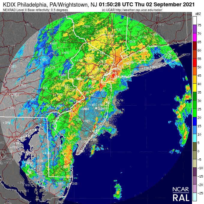
The intense convective (thunderstorm) nature of the rain is illustrated by a weather radar image at 9:50 PM EDT last night, with the red colors indicating extraordinarily high rainfall rates.

After landfall, Hurricane Ida transitioned into a tropical storm and then underwent extratropical transition in which it took on the characteristics of a midlatitude cyclone. The National Weather Service sometimes calls the resulting storm a Post-Tropical Cyclone.But there was a real danger in this transition.
Extratropical cyclones have strong upward motion, often associated with frontal zones, where temperatures and winds change rapidly. And tropical storms undergoing transition often entrain large amounts of tropical moisture that can result in heavy precipitation as the moist air is forced to rise by the storm circulation. This moisture can be converted to rain very rapidly in strong thunderstorms/convection.This is exactly what happened last night.
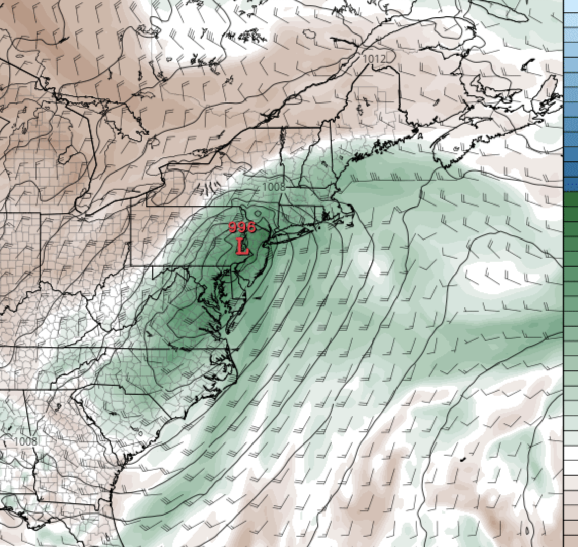
Below is a map of sea level pressure and atmospheric moisture (called precipitable water) for 10 PM PDT last night; you can see the low-pressure center and the plume of moisture (green colors) moving in from the southwest.

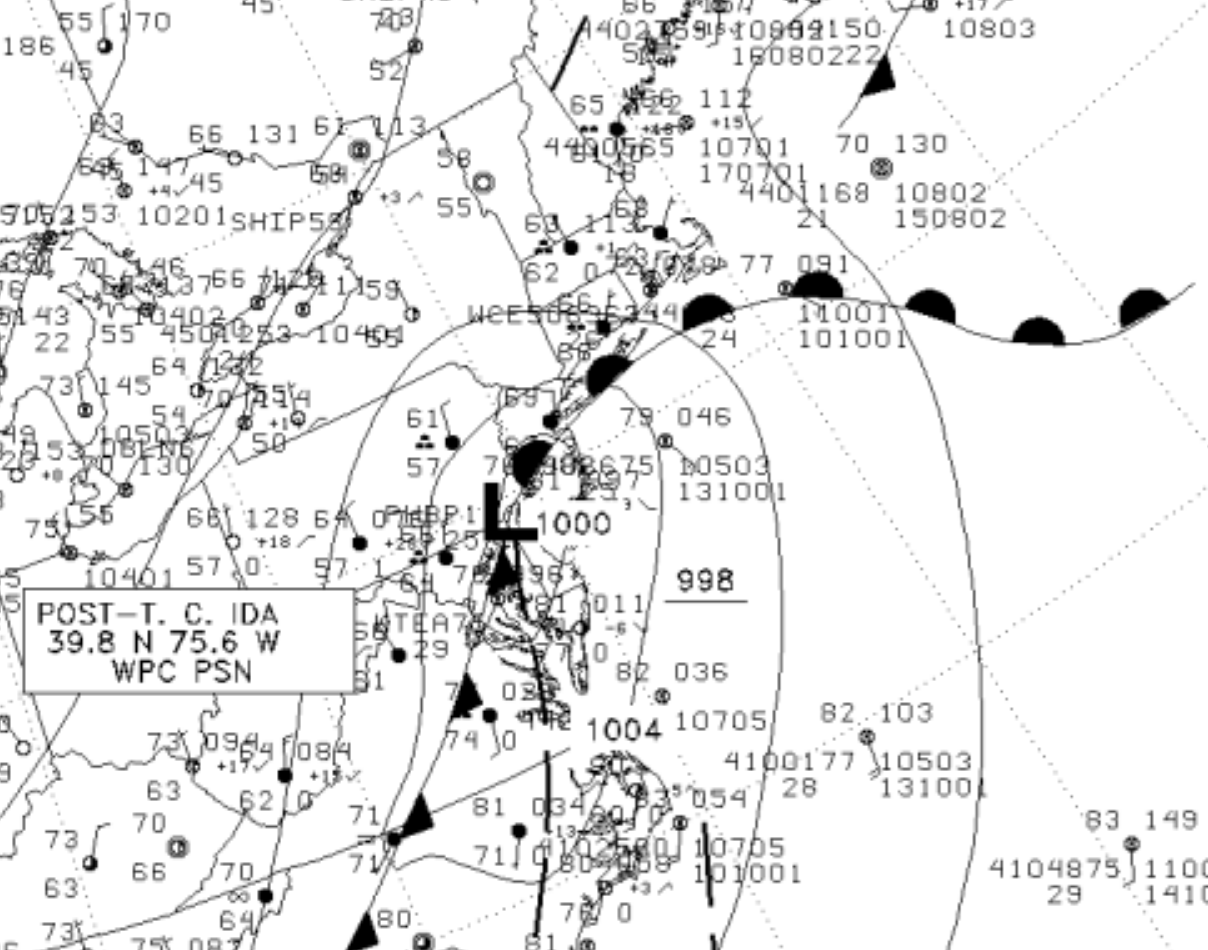
To the east of the low center, there was a warm front, as indicated by the National Weather Service analysis for 8 PM EDT (indicated by the black half circles)

The warm front had warm, southerly winds on the south side and cooler, easterly winds on the north side, with the warm, moist, unstable air to the south forced to rise by the front, resulting in heavy convective showers to the north of the line. That is why the intense precipitation paralleled the front.
The Forecast
My colleagues at the National Weather Service had warnings out much of yesterday for heavy precipitation and the potential for flash flooding, with a flash flood watch out more than a day ahead of time.

Our models were useful but had some issues in both intensity and position. High resolution is critical for this kind of forecast for many reasons, including the convective (thunderstorm) nature of the heavy rainfall, and the sharp frontal boundary that helped produce the rain. 3-4 km grid spacing is a minimum that is viable.
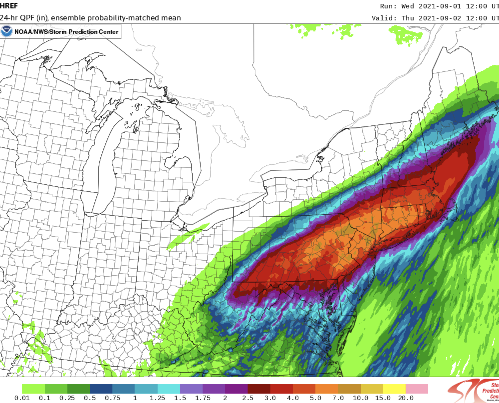
The highest resolution model run by the National Weather Service several times a day is the HRRR model….the High-Resolution Rapid Refresh Model, run with 3-km grid spacing. Its total precipitation for a run starting at 8 AM on Wednesday for precipitation for the next day showed the band, but it was displaced a bit north and somewhat underplayed the precipitation intensity.

The National Weather Service also runs a small (7-8 member) ensemble of several high-resolution simulations (around 3-km grid spacing), called HREF A statistically enhanced mean of these runs (starting at the same time) is shown below. Better.

Everyone involved in numerical weather prediction knows what this country needs to get such forecasts correct: a relatively large (30-50 member) high-resolution (3-km or better for the grid spacing) ensemble of forecasts that are carefully calibrated to give good probabilistic/uncertainty predictions.
Committee after committee, workshop after workshop, have recommended this. The National Weather Service’s own modeling experts say the same thing.
But the investment is never made to do this. This means acquiring the necessary computer resources and building the modeling/statistical post-processing system. Very, very frustrating that this critical capability is pushed off into the future. (Senator Cantwell please take this on!)
Communication
We obviously failed last night. Around a dozen people died in flooded basements. Many people took to the roads that were flooded out. Abandoned cars were everywhere.
There are two stages to the warning process based on time. Yesterday, hours before heavy rain, it was clear that a serious event was in store and people had to be warned in the strongest terms to stay off the road and to prepare.
By late in the afternoon it was clear that a severe event was about to take place, and we needed to get the message to folks not only to stay off the road but to get out of low-lying basement apartments. That did not happen.

Newark Airport
There is no reason why so many people had to die last night from an event we knew was coming and which we could watch unfold with weather radar and surface observations.
Concluding sentence of the above article:
“There is no reason why so many people had to die last night from an event we knew was coming and which we could watch unfold with weather radar and surface observations.”
Of direct relevance to the “reason”, there is Zappa’s Law (aka Zappa’s Canon):
“There are two things on earth that are universal: hydrogen and stupidity.”
— attributed to Frank Zappa (1986); probable rewording of phrase originated by Harlan Ellison (1985)
If a cat4 hurricane makes landfall on a non populated area…does it make a sound?
Are you asking the right question?
Does it make a sound or does it make a noise?
Is it a sound when someone hears it but a noise when nobody does?
It’s a pressure wave when nobody/nothing hears it. It’s a sound if something does. It’s a noise if it bothers someone.
It’s so annoying when someone is so correct.
😜
(Nice, TonyG)
Sadly, I think this is a “feature” – it gives politicians an excuse to “do something”. It may be cynical, but I don’t think the people running things really care about the tragedy, they just want more crisis to exploit.
Unfortunately, I think you are right. Just the speed at which NY politicians started calling it an official disaster may have been an indicator.
I have this stupid problem. This NYC disaster was caused by climate change’ was it? But surely the disaster was climate change? You can’t have climate change causing climate change. So what did? Oh it must have been global warming? But there’s been none for six years and precious little for 150.
Wait – what you’re saying is that climate change got itself pregnant by self-implanting cimate change, and had a baby which was a disaster?
Can anyone do the math on that?
Wait, what? Er, does that make Mikey Mann the midwife or maybe a faulty condom?
Oh, my aching ribs! That was cloudburst funny!!!! Thank you, Richard Page. I needed that!!!!
“Cops were out in the hardest-hit areas”
I thought New York was defunding all those racist meany-head police? Amazing how they are suddenly appreciated when a disaster hits.
How does one “drown” in a basement? Were these people too old to move? Really confusing.
Like always, a post-disaster (in the future, not right now) becomes an opportunity to build safer neighborhoods. These people will be suffering for a while but they can come out of this stronger with good leadership.
The news service this morning indicated that they were living illegally in basement spaces. And it’s easy enough to drown in a basement if the drain is clogged to start with.
One can’t walk up a flight of stairs to the ground floor? One can’t float up to the door to the ground floor?
Some people really are that dumb, as well as lazy.
I wondered much the same, Dave. Here’s one scenario I came up with.
–
If the stairwell floods – almost instantly from a flash flood – and the door opens outwards, and the drain is backing up into the basement apartment, you’re screwed.
You can’t open the door until the water pressure is equalized from the inside, and by then you have drowned.
Check out this video showing a basement flooding in NJ the other day, fortunately everyone survived. https://twitter.com/Bogs4NY/status/1433864450340265987?s=20
One would think that the 28 Trillion we are in debt would have given us the best infrastructure in the world? If not, where did all thatmoney go???
That money never existed which is why it didn’t go anyplace. You can’t make money up out of thin air. Real wealth comes out of the ground.
We’re dedicating a lot of teraflops to pointless climate modeling when that power could be doing the hires weather modeling we seem to need.
Basement apartments suck.
No … they fill. !
Ooh, too soon.
Convective precipitation with the approach of a cold front from the northwest to the warm Atlantic can always be blocked and produce precipitation as high as 100 liters per square meter.
A weak solar wind provides blocking of zonal circulation.
Who is “we” paleface? They made their bed, let them fix it.
If they don’t like the dung pike they voted to create, don’t move here. Move to some Blue State.
They spent all their money on equity and LGBT and BLM protest sympathy to waste it on things like flood control measures.
Diversity [dogma] (e.g. racism), inequity (e.g. redistributive change), and exclusion (“=”) have em-pathetic appeal that can be exploited for leverage.
https://www.marketforum.com/forum/topic/74503/#74533
This was the 24 hour rain for that event.
Note the band of very heavy rains that tracked right along the I-95 corridor, almost exactly where the most people live. …….from Philly to NYC to Boston. That area saw 6+ inches of rain with 3 isolated spots of 10 inches. Much of this fell in a matter of several hours.
Producers/farmers that live in the cornbelt, probably remember a map similar to this with extreme rains at least several times in the last decade. Whether they remember it or not………..it’s happened.
++++++++++++++++++++++++++++
We hear that this is a once a century type event but that’s very misleading.
Once a century………...for any 1 location.…………even while events like this are expected several times a year in the world but scattered around.
The odds of NYC, for instance to see this much rain so fast might be very tiny but the odds for the United States are actually pretty high every year and for the world………..it’s actually very likely/expected that several to numerous places will see rains like this every year.
It just so happened that this extreme rain event occurred where the most people live and it maximized the impact and the coverage.
That said, there WAS a connection to how extreme this and other heavy rain events are becoming with global warming.
At +1 deg. C vs 100 years ago, the atmosphere/air can hold 7% more moisture. Not 700% or 70% more…….7% more. As as result of this, all things being equal(which they never are), rain events like this, should be able to yield 7% more rain.
So the highest totals up near 10 inches, would have been more like 9.3 inches. 5 inches would have been more like 4.7 inches.
The actual weather pattern and hurricane remnant were not from climate change but individual systems, when you superimpose 1 deg. C of warming, can hold 7% more water vapor/precipitable water. So for every inch of rain that would have fallen, you can add .07 inches(all other things held constant).
We can actually use an equation in meteorology that applies to the correlation between temperature and saturated water vapor in the air.
https://en.wikipedia.org/wiki/Clausius%E2%80%93Clapeyron_relation
“Clapeyron equation” and “Clapeyron’s equation” redirect here. For a state equation, see ideal gas law.
The Clausius–Clapeyron relation, named after Rudolf Clausius[1] and Benoît Paul Émile Clapeyron,[2] is a way of characterizing a discontinuous phase transition between two phases of matter of a single constituent. The relevance to climatology is that the water-holding capacity of the atmosphere increases by about 7% for every 1 °C (1.8 °F) rise in temperature.
+++++++++++++++++++++++++++++++++
Yes, this is part of climate change(7% increase in heaviest rains).
Is it killing the planet?
Actually, the thing that is supposed to be killing the planet, is greening up the planet, from the best weather/climate for life in the last 1,000 years(since the last time that it was this warm).
CO2 is still the building block for life and is still a beneficial gas NOT pollution.
Fake beer crisis/Death by GREENING!
https://www.marketforum.com/forum/topic/69258/
A 7% AVERAGE increase in atmospheric water vapor cannot materially affect the ABNORMAL conditions of a tropical storm (TS). The massive amounts of additional TS moisture in a relatively small area over a short period of time is not normal. Since local average atmospheric water vapor varies as to location, wind speed, altitude & etc. and is always very minor compared to additional TS water vapor, the CliSciFi practitioners are lying to you when they say the about 1 C increase in AVERAGE global temperatures (mostly increasing poleward and at night) made TS’s measurably stronger.
Remember, TS are sucking water in massive quantities from the oceans, lakes, rivers and wet land and flinging the water molecules (vapor) skyward. Don’t get caught up in the CliSciFi increasing humidity meme. All we get is a little more rain on average. Then they abuse language to talk about increasingly more severe rain events.
👍 👍 , particularly
“A 7% AVERAGE increase in atmospheric water vapor cannot materially affect the ABNORMAL conditions of a tropical storm (TS).”
and
“Since local average atmospheric water vapor varies as to location, wind speed, altitude & etc. and is always very minor compared to additional TS water vapor, the CliSciFi practitioners are lying to you when they say the about 1 C increase in AVERAGE global temperatures (mostly increasing poleward and at night) made TS’s measurably stronger.”
“Don’t get caught up in the CliSciFi increasing humidity meme. All we get is a little more rain on average. Then they abuse language to talk about increasingly more severe rain events.”
Dave,
I don’t need to listen to /read what other sources think. The data is overwhelming. As a meteorologist for the past 39 years, observing and analyzing global weather patterns, the data speaks loudly.
Deleted hasty, unthinking comment. I need more of my Black Rifle coffee.
Looks like it was pulling moisture up & northeast from the warm Chesapeake Bay waters. And I also like & view the AHPS precipitation analysis webpage — very useful.
Surely the point is to not forecast accurately but throw one’s hands up in a good strong signalling of virtue and say ‘Unprecedented – climate change’!
This is another Katrina controversy. There was another storm-induced surge that flooded New York City around a decade earlier. They have the awareness, the technology, the skill, the greenbacks to mitigate property and human risk.
deleted so ignore.
Shan’t.
ho ho .
Hurricanes-
“NOAA’s Geophysical Fluid Dyamics Laboratory (GFDL): “Leaders in Climate Model Development and Research.” See their website.
For about a decade (or even longer), GFDL has annually updated their statement on hurricanes and climate change. This excerpt from their 15 August 2019 update lists some of their negative findings about current hurricane activity.
“We find that, after adjusting for such an estimated number of missing storms, there remains just a small nominally positive upward trend in tropical storm occurrence from 1878-2006. Statistical tests indicate that this trend is not significantly distinguishable from zero. In addition, Landsea et al. (2010) note that the rising trend in Atlantic tropical storm counts is almost entirely due to increases in short-duration (<2 day) storms alone. Such short does not provide compelling evidence for a substantial greenhouse warming-induced long-term increase.“-lived storms were particularly likely to have been overlooked in the earlier parts of the record, as they would have had less opportunity for chance encounters with ship traffic. …
“The evidence for an upward trend is even weaker if we look at U.S. landfalling hurricanes, which even show a slight negative trend beginning from 1900 or from the late 1800s. …
“While major hurricanes show more evidence of a rising trend from the late 1800s, the major hurricane data are considered even less reliable than the other two records in the early parts of the record. …
“In short, the historical Atlantic hurricane frequency record “In short, the historical Atlantic hurricane frequency record does not provide compelling evidence for a substantial greenhouse warming-induced long-term increase.“
Louis Uccellini is a prat. I’ve heard him speak and he is arrogant and dismissive. I have seen his actions as head of NOAA’s Environmental Forecast Center and of the whole National Weather Service, and he is self-serving and unimaginative. A lot of our weather forecasting problems are due to this incompetent fool. You-know-what floats to the top.
This, from my own neck of the woods in NZ. Hope you can read it. It needs an update, but you get the gist. It put some of the local alarmists to bed, for a while at least. Here, very extreme rainfall events are very localised – sometimes less than 1 km in diameter. 5″ in one hr have been recorded. High rainfall events and flooding are very seldom unprecedented. We know this from the records and the stories from Old-timers.
Mods: could you check for my stray comment. It was on topic and no other issues to block it. Thx
The Biden Administration seems intent on using this to promote its “infrastructure” plans. One must wonder, however, how flood resilience is improved by “free” community college or a network of EV charging stations.
How do all-electric vehicles behave on flooded roads? Do the batteries get damaged driving through high water?
Too shocking to talk about
If water gets into the battery compartment (which is usually low down in the car and often accessed from underneath) and inside the battery then it would be bad, very bad – almost ‘crossing the streams’ bad. If the lithium in the battery is exposed to water then expect a violent reaction, lots of gases given off (including hydrogen) just before it goes up in flames. A word of caution – do not ever drive an electric vehicle through flooded streets.
Don’t be such a ninny, Richard. Nobody drives an EV through flooded streets more than once.
😜
(As you describe it, they never get a second chance to do it again.)
Reminds me of a favourite quote: “Everything is air-droppable. Once.”
This unfortunately is a case of crying “wolf” .. err .. “existential” event one too many times.
No only a weather forecasting failure, but this exposes a massive past failure to update infrastructure despite past problems. New Jersey has allowed building in low-lying areas and known flood zones. That New York City transit didn’t stop subway trains and evacuate people to the surface streets is shameful.
Here Andrew Bolt and Bjorn Lomborg discuss the actual deaths from extreme weather events over the last 100+ years.
Then less than 2 bn people at risk and today 7.8 bn at risk, DUH.
And the DATA shows that deaths from extreme weather events have fallen OFF a CLIFF since those earlier,very dangerous times. CHECK OUT the GRAPH for yourselves.
Up to July 2021 deaths from extreme weather events around the world have been at record lows AGAIN.
How can they get away with their BS and fra-d and so little condemnation from our MSM extremists?
Little wonder that the young girl at the demo is so afraid and fears for the future.
Unbelievable but true.
Alex Epstein’s quote is the best when referring to extreme weather events.
“Fossil fuels haven’t taken a safe climate and made it dangerous they’ve taken a dangerous climate and made it safe”.
Just check the extreme weather DATA over the last 100 years and beyond and WAKE UP.
I thought everyone understood this factual data by now, but apparently NOT.
BTW who is advising the clueless so called leader of the free world?
https://notalotofpeopleknowthat.wordpress.com/2021/09/01/fossil-fuels-havent-taken-a-safe-climate-and-made-it-dangerous-theyve-taken-a-dangerous-climate-and-made-it-safe/
Karl Marx and The Three Stooges are currently advising Joe Biden.
If only, Tom. He would be doing a much better job with the Stooges advising.