By Joe Bastardi |August 20th, 2021
The situation with Henri is growing dire. I strongly believe this will be stronger than the National Hurricane Center has at landfall. Their track has come to ours and ours is likely going to shift to the west this afternoon.
Note the SSTs to the east of the Virginia Capes:

This is as warm as the Gulf Loop Current. The outflow pattern tomorrow is as textbook-perfect as it can get, with two jets ventilating it.

Keep in mind unlike other storms in this region, Henri is coming into this area to intensify. Most storms that hit New England are coming out ot their area of highest intensity. Consequently, my call on intensity is down to 960 mb or lower at its peak late tomorrow afternoon or night, and a hit at 980 mb or lower. The water is quite warm relative average, even to the coast:

Low-level inflow and great upper-level support until landfall mean the weakening may be slower and only relative to how strong it gets in the first place.
Note the SSTs when Bob hit in 1991:

It was coming out of its area of maximum outflow support., not into it, and SSTs were much cooler. This current situation is the opposite:

As per our morning discussion, this will join the who’s who of the greatest storms in this area and for some will become the new benchmark. A shift to the west in my track (and I don’t like to do that since we have been stronger and farther to the west all along), is becoming more likely.
This storm is something my dad would talk to me about for years when I was young, the shortcut storm that hit the northeast moving west of north, There is nothing that says this cannot happen. After all Fran, in 1996, was moving west of north all the way to western PA, this is just displaced east. But like the Texas freeze where I was doing cartwheels trying to get the media to pick up the week before, the bread and circus of the media and politics is ignoring what may be a dominating story by Monday morning. And what’s more, the weather weaponizers will be out in full force, when the very person who exposes this stuff has been talking about this for years for one, in our preseason forecast for 2 and all this week for 3. It’s almost like they are climate predators, they wait until after, then pounce on the unsuspecting which is almost everyone since no one is paying attention until it’s obvious. Then they turn around and come after the people who were watching it, yelling they deny climate when climate and past events is what they use to set this up from afar!
The best one can do if the mission is like the Watchman in the bible is to try to show to all who will look and listen. And understand who it is who does not want that out until it can be used for their own purpose.
Henry is weather, not climate, but the time to prepare is NOW.
Author

is a pioneer in extreme weather and long-range forecasting. He is the author of “The Climate Chronicles: Inconvenient Revelations You Won’t Hear From Al Gore — and Others” which you can purchase at the CFACT bookstore. His new book The Weaponization of Weather in the Phony Climate war can be found here. phonyclimatewar.com
National Hurricane Center
Tropical Storm Henri Forecast Discussion
https://www.nhc.noaa.gov/text/refresh/MIATCDAT3+shtml/210853.shtml?
Yawn. It’s a tropical storm. Long Island will take the brunt, the CT shore will see some nice TV pictures of waves, and upstate New York and Vermont will get inundated, hopefully nothing like Irene.
Yep, the estimated track keeps nudging further west. New Hampshire will get the leftovers – I’m guessing in the 2-3″ range, although the southwest part of the state could certainly get more.
Hey! Maybe the west side highway will actually be underwater for a short time and then the climatistas can claim their messiah was correct!
I liked it better when they named the Hurricanes after women. Then the feminists complained. Not one woman complained about a hurricane being named after them.
Joe Bastardi is right the MSM will be hawking it as proof of climate change and we may even see Al Gore advertising carbon credits. All after the fact.
I have neve r been near a coast when one of these storms comes ashore, so,I will head to Silver Point on Long Beach island to see what’s what.
The only Long Beach Island I know is a barrier Island off New Jersey.
A cold front from the west and a storm along the east coast looks like a typical fall storm.
On Wednesday at the start of our overnight flight to London from Dallas, Texas the captain announced that he was taking the overland route across the US as this would give us a smoother journey. At the time I had no idea why he made this decision. I am now using my quarantine time to catch up with this storm’s development..
The 1938 New England Hurricane, now that was a storm to be reckoned with (no relation to Amanda B.). They just don’t make ’em like that anymore. Must be “climate change”.
We had some good storms then. A flood in 1936 wiped out most of the mill dams here in Sutton Mills, a calamity the village has never really recovered from. While the river is across the street from me, my house was built in 1860, so I may be safe should there be a repeat. Not so sure about the garage.
Other storms – see my https://wattsupwiththat.com/2013/09/21/weather-before-and-after-the-hurricane-of-1938/
Henri is no Hurricane of ’38!
They just shouldn’t let them build there … that the problem.
Drown libs drown.
I remember a hurricane that hit Brooklyn in 1944, and knocked down a lot of trees. What’s so special about this one? Ignore the hype.
So, just what is Joe B predicting?
That may well be a better way to measure intensity, especially storms with a fast forward motion or are in an eyewall replacement cycle.
http://www.atmo.arizona.edu/students/courselinks/fall10/atmo336/lectures/sec2/hurricanes.html has a graph that converts central air pressure to wind speed (in km/h). 980 mb at landfall is some 135 km/h, or 81 mph. Oh, hey – that’s Cat 1! Ranges 74-95 mph 64-82 kt 119-153 km/h.
Color me unimpressed.
Out at sea, 960 mb is 180 km/h, 120 mph, that’s better (Cat 3), albeit over water (big waves, not big destruction). Hmm, should check my conversion – I was mentally converting 1 km to 0.6 mile. https://www.nhc.noaa.gov/aboutsshws.php says Cat 3 is 111-129 mph, 96-112 kt, 178-208 km/h and that 180 km/h is very low end.
And what does the NHC have to say in its 2300 update?
The map shows it’s east of northern VA, where Joe said it was going to intensify to 960 mb.
Don’t be surprised if it’s not a hurricane at landfall.
Any chance this storm will drown Joe Talibiden in his Delaware basement?
I am exactly down the middle of the projected track for this storm passing through north central Connecticut tomorrow.
Other than stocking up on water, batteries, and non-perishable food, this thoroughly precedented weather event is out of my hands.
It is what it is. And what it is not is anything to do with climate change, unless it’s a sign of a return to the cooler, stormier times we had in the 50s through the 70s.
Happily, a non-event for me. Not even close to the strongest storm of the season.
Speak for yourself snowflakes. I’ve never been afraid of the weather, but thanks for the heads-up.
The first thing I noticed wa the intricate DETAIL of his graphs! WOW! I was almost able to figure out where it was!
It’s going East. Any bets on no landfall?
You got that right for Long Island
Good thing we didn’t have a Cat 3 hurricane hit Long Island when CO2 was below 350ppm in 1938
Henri eye passed directly over NDBC station 41001 just before noon.
https://www.ndbc.noaa.gov/station_page.php?station=41001
The storm wall was slightly stronger on the trailing side compared to the leading side.
Maximum sustained wind speed recorded by the buoy was 31 knots.
At the same time the NHC stated that Henri was Category 1 which is 64 knots.
To be fair, the anemometer height was 4 meters above the surface.
The next buoy in the path is 44066.
Then the real test will be station 44017 which is 23 miles off Montauk Point
I hope it’s a direct hit on democrats.
Wipes ’em out.
Known New England striking hurricanes (categories at landfall):
“The Colonial Gale” – 1635, estimated Category 3.
“The Great Storm” – 1815, estimated Category 3.
“The New England Gale” – 1869, estimated Category 3.
“The Great New England Hurricane” – 1938, measured Category 3 (petered out in Canada).
“Carol” – 1954, measured Category 3.
“Gloria” – 1985, measured Category 3.
“Bob” – 1991, measured Category 2.
Source – The Washington Post.
Thirty years, one would almost say that one was overdue. Most of them have been Category 3 at landfall, too, except for Bob. Looks like this is another one.
Now a southward-flowing Atlantic jet stream is pulling the hurricane away from the US east coast.

Current situation.
It is now the middle of hurricane season. Tropical waves in the Atlantic need to be tracked.
Currently, a large drop in air temperature is evident in the Southern Hemisphere.
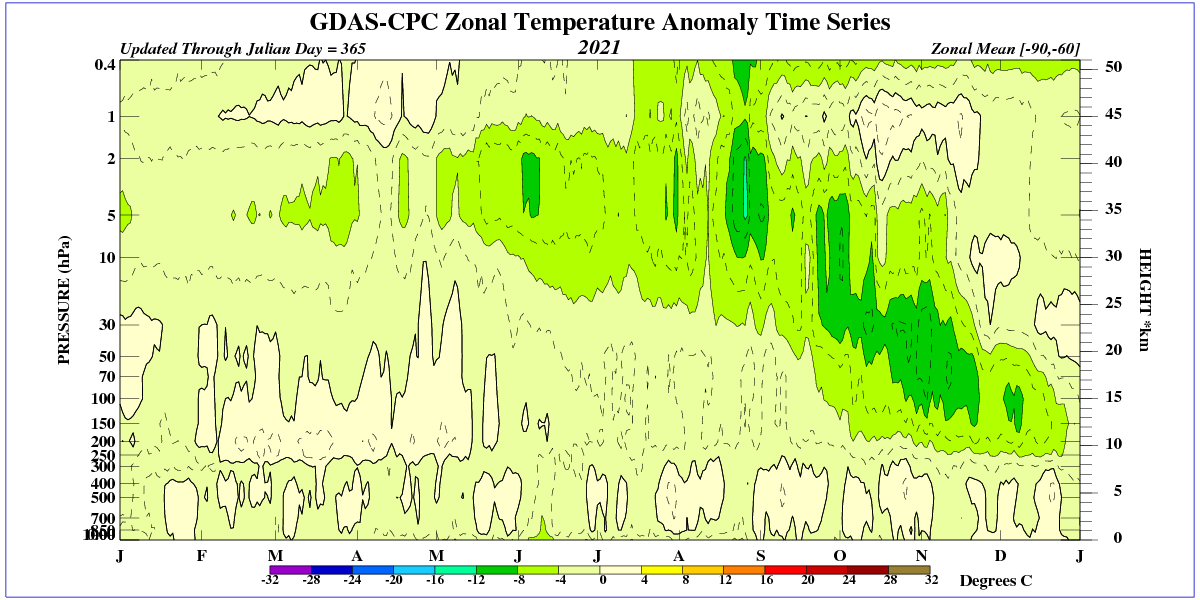
This drop is associated with a marked decrease in temperature in the upper stratosphere due to a decrease in UV radiation during the 25th solar cycle.
https://www.iup.uni-bremen.de/gome/gomemgii.html
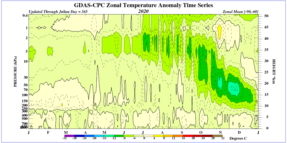
This drop was also evident during the previous winter.
See the ozone hole in 2020.
I predict a very snowy winter in the northern hemisphere due to warm oceans in the northern hemisphere and a drop in the temperature of the troposphere during the winter.