Reposted from the Cliff Mass Weather Blog
June 26, 2021
A One-Hundred Year Heat Wave Event Comes Into Focus
As we get closer to the big heat event, powerful new forecasting tools are becoming available. Tools that provide a higher resolution and more nuanced view of the extreme heatwave event that is about to happen.
One such tool is ultra-high resolution numerical weather prediction models. My group at the University of Washington runs the highest-resolution operational weather prediction system in the region, with a grid spacing of 1.3 km. High enough resolution to get many of the local water bodies approximately correct, as well as the impacts of our regional terrain features.
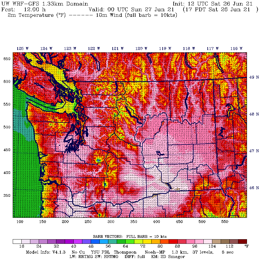
Let me show you the surface air temperatures predicted today through Monday…all shown at 5 PM.
Today, Portland and the lower Columbia Basin surges above 100F and Seattle rises into the upper 90s. The kind of conditions we typically experience once or twice each summer.

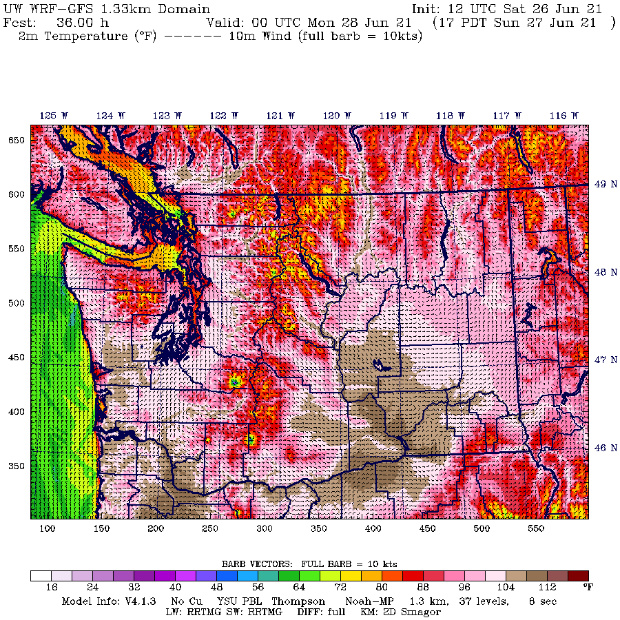
Sunday afternoon is a much warmer story. Portland is above 104-108 and the central Puget Sound away from the water is above 100F.

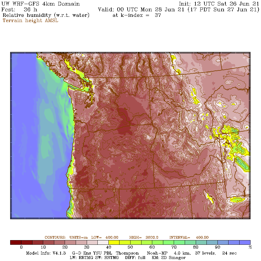
What about humidity? Will the air be so moist that evaporation on your skin won’t be effective? The answer is no.
Here is the predicted relative humidity at the same time (5 PM Sunday): most of the region will have relative humidity below 30%. Sweating or wetting your skin will provide substantial cooling. Very good.

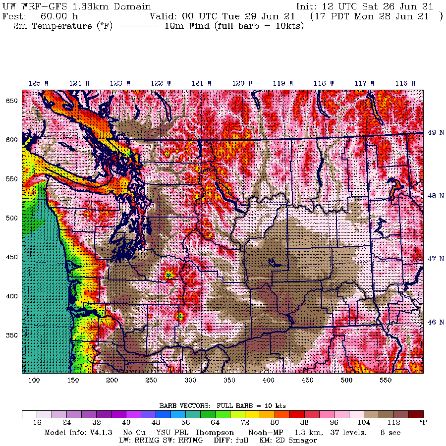
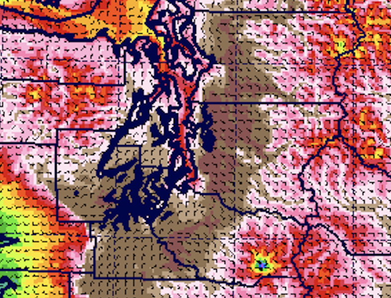
And then there is Monday, a day that will be the warmest in the past century for portions of western Washington.
Just madness. If you are right on Puget Sound temperatures will be tolerable (80s), but go inland a few miles and temperatures will zoom above 104F. Go inland a bit more, temperatures will be above 110F. I have provided a zoomed-in view for better viewing below. I never expected to see such temperatures in my lifetime.
Eastside communities like Bellevue, Redmond, and Woodinville will be hit much harder than Seattle, Tacoma, and Everett.


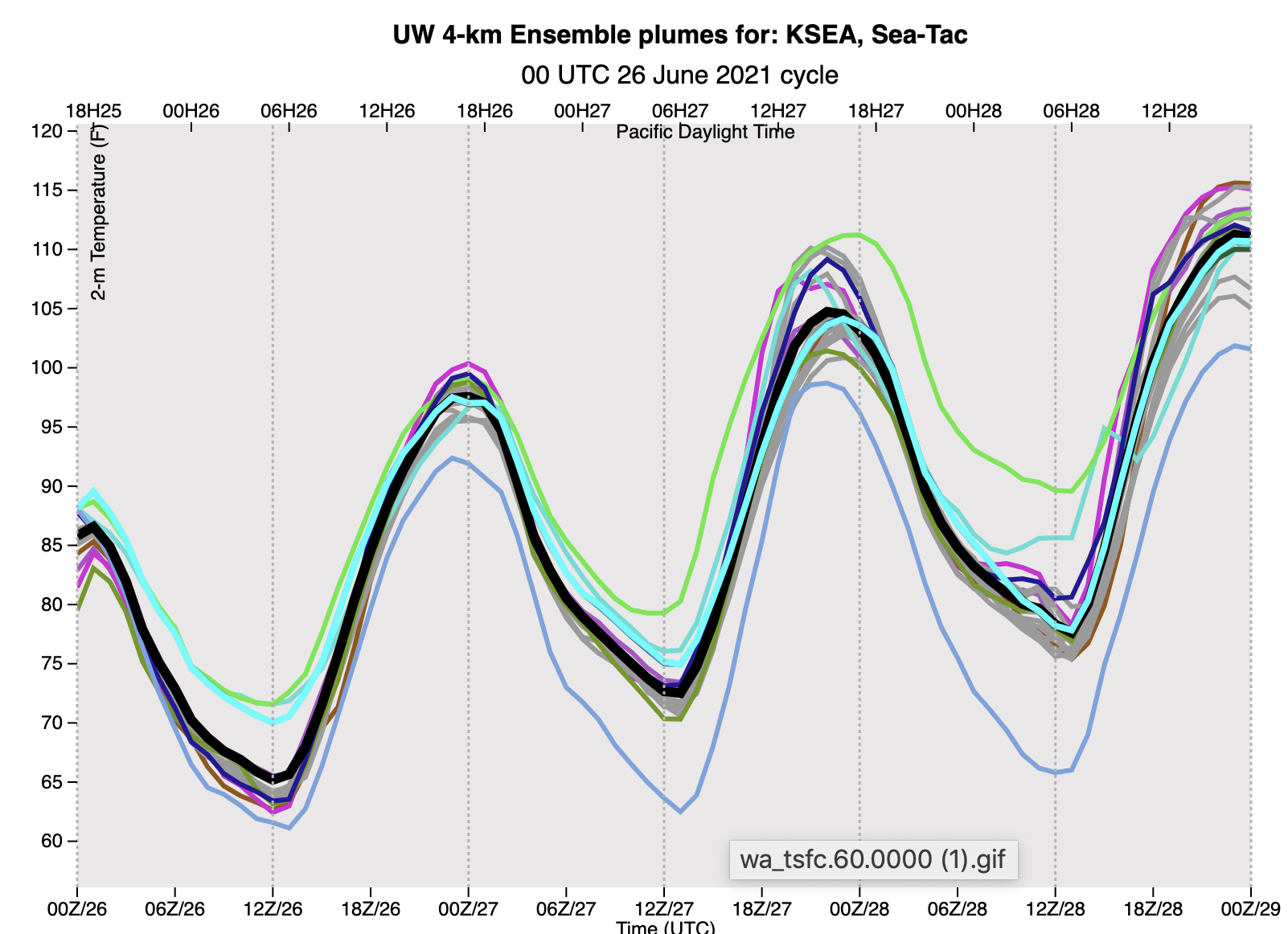
Another powerful tool is high-resolution ensembles of many forecasts, which allow us to see the uncertainty in the forecasts.
Here is the University of Washington high-resolution ensemble prediction for the temperature at Seattle Tacoma Airport, with the black line indicating the mean of all the forecasts (a good forecast in general). Today (00/27) has the ensembles on the same page (the upper 90s). More variations on Sunday, but nearly all above 100F (man about 104-105). And on Monday the mean is around 110F, with a range of 100-115. Yikes.

Now I have been somewhat fixated on high temperatures, but nighttime lows are also important because they greatly influence the quality of our sleep and ability to cool down our homes and apartments.
The ensemble predictions above indicate a substantial increase in daily minimum temperatures, with temperatures on SundayNight/Monday morning only dropping to around 75F.
Wow…that is more than our typical highs this time of year (~72F). It will be very hard to cool off before the super warm day on Monday. We will be breaking major low-temperature records–the highest low temperature in history–at many stations.
The good news in all this? Tuesday will be considerably cooler, but still way above normal. More on that in my next blog.
When this is all over, I plan to do a detailed examination of this event in the context of global warming.
Here in calgary they are talking about an unprecedented heat wave that if we get 6-7 days above 30c it will be the first time ever…….since 1912.
So global warming finally got us back to where we were 109 years ago
Yay global warming
Don’t get your hopes up Pat. Winter will be back, come September:)
Portland airport hit 111 in the last 30 minutes which surpasses yesterday and is the new all time hottest ever/record. I noted an EAST wind at 11/12mph. This is taking the already hot air to the west and downsloping it on the west side of the Cascades which is adding to the heat.
Portland NWS: https://www.weather.gov/pqr/
Seattle NWS: https://www.weather.gov/sew/
The hottest temperature in Oregon history was:
117 °F / 47 °C July 27, 1939
https://en.wikipedia.org/wiki/U.S._state_and_territory_temperature_extremes
https://www.marketforum.com/forum/topic/71468/#71660
This is taking the already hot air to the
west(should be east sorry about that) and downsloping it on the west side of the Cascades which is adding to the heat.The forecasts appear to have been high by 4F. My area was forecast for106F. The high has been 102F. Portland Oregon is currently at 108F, missing the 112F forecast according to WeatherBug.
Oh no! Weather variability means my parents should’ve stopped driving cars in the 60s! We’re doomed.
Except when it’s unseasonably cold and then it’s just random weather.
I was out working in this sh*t all day – driving a truck over the mountain. Up in the hills it was around 99-102 – when I got back into town just now, at 4:40 it’s 108.
It DID get to 113 inside my car sitting in the parking lot all day.
That’s in the hills fourteen miles west of Portland OR.