By Rud Istvan,
The mainstream media (MSM) is abuzz about the present Western Drought allegedly caused by ‘anthropogenic climate change’. Lots of ‘we are gonna die’ stuff. Charles has a way of provoking thoughtful investigations. He asked me, ‘does this mean future California electricity blackouts from lack of hydro’? [HT/Macusn~cr] Which intriguing question set me off on another quest for climate truth. Only a few key references are provided below, as most of what follows is easily googled.
Anthropogenic Climate Drought?
Alarmists need to be a bit more specific as to where and when and why. This post covers the Columbia River basin, the Colorado River basin, and California. In that Western US geography, the ‘drought’ is mainly in the Colorado basin and California, in both from lack of Sierra and Rockies snowpack. The Columbia basin is so vast, that even in the previous ‘peak’ California drought year of 2015, the Bonneville Power Administration (BPA) experienced no water flow problems across its 33 hydroelectric dams since there was no drought in British Columbia.
Just focusing on California and the Colorado basin, tree ring studies peg the present situation as only the fourth worst in the last millennium. Abandoned Chaco Canyon proves it was previously much worse. Chaco was abandoned about 1250 because of a worse western drought than at present.

And the three previous ‘worse’ droughts can have had nothing to do with anthropogenic ‘carbon pollution’, which a greening Earth seems to like as fertilizer.
That objective history is, however, still a problem for the Colorado Compact, formed at the time of the Hoover Dam and Lake Meade. The 7 states plus Mexico water allocations were based on annual Colorado flows from a (abnormally) wetter prior decade. So just wrong hydrological assumptions.
Electricity Impact?
We need to separate California from the Colorado Compact for purposes of analysis. The data sources for the facts below are primarily from the US government’s EIA at EIA.gov, from the California Energy Commission (CEC) at Energy/Ca.gov, and from an open access paper ERL 15 (2020) 094008.
California 2019 electricity was 16.5% supplied from the states internal ‘large hydro’ (about 287 dams like Oroville, which almost collapsed from TOO MUCH water in 2017), or imported from BPA hydro 9.7%. ‘Small hydro’ inside California supplied 2.7%; imports were only 0.4%. So California only hydro in 2019 was about 19.2% of CA generation. 2019 is used as the baseline because 2020 numbers are not yet available mid 2021. Dunno if Covid or just gov work pace.
In 2015 (peak previous drought year) that output was cut to 41% of 2012 pre-drought output, meaning that maybe in 2021 it would be cut to (0.41*19.2) 7.9%, a drop of about 11.3%. Now most grids run with on the order of 12-15% reserve capacity, so the California grid can maybe handle this loss without going dark.
There is, however, an interesting ‘brought to you by the government’ BPA qualification, since in 2019 when you add imported BPA, total California hydro was about 26%. The BPA issue probably isn’t drought water, based on 2015. It is that 1/3 of BPA capacity has ALREADY exceeded its design life, and they are not keeping up with replacement. An unplanned outage is possible. Plus, for sure by 2030 California will be on its own, since Washington State just passed a law mandating all its electricity will be green by 2030, meaning no California exports.
The Hoover Dam/Lake Meade hydro electricity mainly goes to Nevada and Arizona, albeit on the western grid connecting to CA. Their electricity issue is a different one. Hoover Dam has 17 hydraulic turbogenerators. These have a thing called ‘deadpool’, below which the hydrostatic head cannot safely spin them and they must be shut down. That deadpool was a Lake Meade original design elevation of 1050’. In 2015, Meade got down to 1085’, scaring everybody. So in the past 6 years, all 17 Hoover hydroturbines have been replaced by a new design that lowers the deadpool to about 950’. As of this week, Lake Meade stood at an alarming ‘record low since 1937’ of 1071’, only about 36% of full water capacity as evidenced by its ‘bathtub ring’.

Not good for water supply (below), but still far from an issue for its new electricity deadpool.
Water Impact?
Obviously there will be one, but again one has to separate California from the Colorado Compact.
In California, about 50% of water is used ‘environmentally’ (northern California salmon run rivers, and the central CA infamous delta smelt), about 40% in agriculture (the Imperial Valley fruits, nuts, vegetables, and dairy), and about 10% for ‘people and industry’.
One semi-serious idea is to declare the delta smelt extinct (nobody has seen one for years), and reduce ‘environmental’ water use in favor of ‘agricultural’.
The bigger reality is that ‘people’ will never suffer, but some farmers may. Nobody is going to ‘die’, but some farmers may be driven out of business. The subject is a bit more complex (as in Arizona), because of grandfathered water rights to pioneer farmers who were there before Silicon Valley thirst.
There is a related interesting water related Cali agricultural ‘factoid’, known to this near four decades Wisconsin dairy farm owner. The number one milk producing state is California (18.6% of US), while Wisconsin is only #2 (14%). Why, given that the main dairy feed is protein rich alfalfa, a very water intense hay crop? About 1.2 million acres of alfalfa in California, all irrigated. The reason turns out to be a simple but foolish political policy. Milk has had (since FDR) price supports. And ground zero (no support) is Madison, Wisconsin. The further from Madison, the higher the milk price support. And California is the farthest CONUS distance from Wisconsin. California is subsidy farming milk price supports from irrigated alfalfa using water it doesn’t presently have.
In the Colorado Compact, the same generic issue exists. About 70% of the water goes to agriculture, and about 30% to ‘people and industry (like Elon Musk’s massively subsidized Nevada Gigafactory)’. The principal ‘people’ beneficiaries’ are Las Vegas and Phoenix. They will never suffer, although farmers might (again subject to grandfathered water rights complications). As one newly discovered factoid, about 1/3 of all the fresh vegetables grown in the US are grown in the Sonoran desert south of Phoenix using Colorado irrigation water.
Conclusions
Neither California nor Las Vegas will go dark because of the current drought, which itself provably isn’t attributable to anthropogenic climate change.
Nor are Los Angeles, Las Vegas, or Phoenix going to parch, although some farmers may become rich by selling their grandfathered water rights to these thirsty newer cities, and then ‘retiring’ while their former desert restores itself.
Interesting review of yet another policy distortion
Oregon is also in drought, especially in the Klamath Basin, which river flows into CA.
La Nina causes moisture-bearing storms to hit WA and BC rather than the OR and CA Cascades.
As I type the rain is pouring down here in the Willamette Valley. The rivers are overflowing. The soil is saturated. The aquifer is fully charged. Cars are hydroplaning. How do you define “drought”?
Btw, Klamath farmers have lost their water rights in favor of salmon and suckerfish, yet those fish populations have not responded to the added water. Lots of virtue signalling backed by junk science, and inflicted bankruptcies, but no effect on the fish.
Drought? Unfortunately nobody told the slugs, which are unusually abundant. The mildew has mildew. My neighbor told me he thought somebody stole his pickup truck, but then he mowed the lawn and there it was! And the rain is still coming down in buckets. Evidently drought in Oregon excessively damp compared to other places.
Really? Somebody gave me a minus, but nobody answered my question. How can you declare a “drought” in the pouring rain?
Is less than average precip between two arbitrary dates a “drought”? Is less than average snow pack in June a “drought”?
Is a completely corrupt media and/or govt. agency using Alarmist rhetoric to frighten the citizenry into accepting more govt. control of their lives just a fairy tale or a solid fact of our current situation? And is knuckling under to accept basically absurd declarations from well-established propagandists proper behavior of free thinking humans?
Okay, you win. It’s a “drought” with pouring rain. My problem is I haven’t yet learned how to disbelieve my own lying eyes.
Did not know of the milk /alfalfa information. Thank you.
I didn’t know that “1/3 of all the fresh vegetables grown in the US are grown in the Sonoran desert south of Phoenix”.
My ONE foray into the life of a farmer was working on a hay ranch in So. Oregon. We grew #1 alfalfa that we sold direct to the dairy farmers of Oregon. The alfalfa was watered 24/7 by overhead sprinklers fed by underground artesian wells. Yes. It is a water intensive crop
I guess we don’t need as much milk as people switch to soy “milk” or nut “milk,” so maybe they can use the water for something else.
False, the reduction in milk consumption is based on anti-cattle superstition green activism and will have a detrimental effect on health in the long term. And California was once the leading U.S. supplier of almonds and high on the list for soy–which is easily grown in standard rotation. Can’t grow either sort without water, which California is mismanaging.
As a dairy farm kid from upstate NY, I fail to see how you get “soy or almond milk” as a “natural product”. Me thinks there is a whole lot of processing going on in between those natural state solid foods, and a milk product. Only “city folk” can call them “natural”.
“Alfalfa roots may penetrate over 20 feet deep. This great rooting depth gives alfalfa excellent drought tolerance.”
Certainly, the more that alfalfa is irrigated, the quicker its growth and the quicker the turn-around time between successive cuttings and balings.
Don’t worry — within 10 years there will be no more problems — says AOC. These Villagers may be enjoying their last boat ride — so sad … https://www.youtube.com/watch?v=D9OeWswZGaQ
Rud:
I believe that Colorado water is relatively hard. What effect does that have on long-term irrigated soil?
Causes salinazation, TDS left behind as salts, if excess water is not applied to leach the salts away from the crop.
Not much. Hard water is mostly dissolved calcium carbonate. My farms soils are full of limestone chunks, and the alfalfa, corn , and soybeans thrive.
The irrigation problem is mainly slow salt buildup, a factor in parts of southeastern California (Salton sea) and in India. Without sufficient rain to leach the salt, it eventually poisons the soil. Covered this in my ebook Gaia’s Limits in the long food chapter. Per FAO, the decadal global loss of irrigated arable land is about 5%, presently offset by ‘new’ arable land from, for example, agriculture intruding into the southern edge of the Amazon rain forest. Not good if you look out several decades.
Forgot to mention. The bathtub ring image proves both that the water is hard and that it is mostly dissolved calcium carbonate.
Complicated problem.
Selenium build-up (Kesterson effect) is a serious problem that is now being better managed in the San Joaquin basin. As the graphic below shows, the San Joaquin is the only natural outlet to the sea from the Western SJ valley. Thus the only way to naturally flush out the accumulating high selenium run-off from the coastal range run-off into the valley streams and then to the water table.
https://www.usgs.gov/mission-areas/water-resources/science/linking-selenium-sources-ecosystems-irrigation
But the Se doesn’t come from Colorado river water. The link itself names the sources, and the graphic shows the Sacromento and Kern drainage systems with Se coming eastward from coastal range and alkalai desert drainage.
Colorado contributes to AZ and Southern CA agriculture and urban areas. The hardness of Co river water does not hurt the soil, and is optionally cheaply removed for human consumption.
I can bear witness to this. Salinization (sodium chloride) from natural water sources of the Colorado does not happen. Magnesium and Potassium salts, from natural or human sources, are actually good for plants, but occur in extremely small quatities.
The natural water from the Colorado is “hardened” mostly from calcium carbonate, as you say, and does plants much good, among other things deacidifying soil (and eventually the Gulf of California).
Most of the Colorado drainage is very fertile, and has been so seasonally for millenia.
Sodium chloride salt is a form of pollution, mostly from human sources, but absolutely rare from natural sources. It is still a filler in a lot of detergents.
In Arizona from time to time we mix Sulfuric acid with the irrigation water to dissolve the mineral buildup. Occasionally the farmer will flood the field and drain the water to wash away the salts. The problem is what do you do with the waste water. They have constructed drain channels separate from the water supply to dispose of the salty runoff.
Normally the runoff water from the field is captured in a settling basin to separate the silt then it’s pumped back to the field. Waste not, want not. If you don’t remove the silt from the water, it will wear out the blades in the pump in just a few days. Cleaning out the silt from the basin allowed my dad to feed us and helped pay for my education.
Rud,
I love your tongue-in-cheek write-up.
If sanity prevailed, there would be plenty of water for every use.
That would require rationing by means of taxing water use per gallon, an equal rate for all uses.
The tax would increase, based on the available water.
People, industry, farming, etc., would quickly find ways to limit their water use
Irrigating by spraying water in the air is idiotic, as about 50% is lost before it is absorbed by the plant.
In Israel, a dry and very prosperous place, drip tubes are used to directly water plants, as required by law.
Calizuela does not have a water problem.
It has a nutcase problem, aided and abetted by Newsom and his enviro-maniacs
As is spraying that water during the hottest portions of the day. Much water is wasted across the West and Midwest.
Interestingly, on the east side of the Rockies in Colorado, it’s much wetter than average. Two things are striking to me this year, however. There is going to be a bumper crop of ragweed. On some of the trails that I bike, I’ve never seen so much. For whatever reason, unfortunately that plant is thriving.
Normally by this time, insects would be thriving. That’s not the case this year so far. Even with all the rain, the mosquito population has been low and I’ve seen only a few bees. I didn’t see a single bee on my flowering trees this spring, which is atypical.
“Calizuela does not have a water problem.
It has a nutcase problem,”
You got that right! 🙂
Stupid question- as silt slowly raises the bottom of the lake – won’t this raise the level of the surface of the water near the dam? So, that’s a good thing? And, what is the rate of sedimentation?
The level does not rise, the depth decreases.
Doesn’t matter. To preserve the Colorado in its ‘natural state’ below Hoover, once a year they sluice it for a few days using Meade bottom water. That flushes the sediment so it doesn’t build up. Is sent downstream.
Really? The following web site discusses this issue and doesn’t mention sluicing: https://www.nps.gov/lake/learn/nature/sedimentation-lake-mead.htm
I’ve found several other web sites discussing this issue and none mention sluicing. But the lake built upstream (Lake Powell) is now retaining much of the silt so silting in Lake Mean isn’t a problem and won’t be for centuries.
Hoover now releases into Glen Canyon dam, finished 1963. Glen Canyon bottom release now does the annual Grand Canyon spring flood. Used to be Hoover. USGS has a publication on what it calls the annual scour. Sluice was not the correct technical term; it’s scour.
Huh? I think you misspoke. Glenn Canyon dam and Lake Powell is well above Lake Mead and Hoover Dam.
Hoover does not release into Glenn Canyon dam. The opposite is true.
the dam immediately South of Hoover is the Davis Dam.
Yup. Got them mixed up.
Thought so.
Lake Powell release is used to maintain Lake Meade at necessary and agreed to levels.
When questions are politely asked why does any reader of WUWT downvote that comment?
Usually a knee jerk reaction to something that doesn’t match their opinion in some way either about the subject or the OP.
yuh, I was wonder about that- I’m really racking up the negatives today- not that I care- I hate the climatistas as much as anyone here- since they want to end all forestry, which I’ve been doing since Nixon was in the White House- and when done right, it’s a great thing- though much of it is poorly done
We have six or so alarmist trolls frequenting this website, so if you don’t get more than about six down votes, then you shouldn’t worry about it. It’s probably those guys, and they can’t be considered unbiased observers.
I like that they’re around- because when the climate realists here deconstruct them- it’s a good learning experience for me- since I hear the same kind of BS every day here in MA- helps me respond to the climatistas here.
JZ, could have used you on my Wisconsin dairy farm. Had three plus woodlots, each about 40 acres, mixed hardwoods. Because when I bought it all were in a woodlot tax easement, state forced a logging with trees marked by state foresters. The logger did a botch job. Didn’t take out wolf trees, did take out good but immature stuff. We did another logging 20 years later, and even though I was much more careful (private forester marked the trees, recommended logger) there were still some supervision problems like big old red oaks that the logger missed because on steep slopes, that then got winter storm damaged.
Once got offered $11k stumpage for just ten big straight mature oaks on my very steep non-woodlot strip slope from the pastures down to the county road. Declined because of erosion fears: over two hundred feet of elevation in a 100 yard wide (horizontal measure) strip. They offered to drag the crowns up to the pasture for firewood. Would have made erosion worse by damaging the understory.
Will say, tho, we never lacked for fireplace hardwood from the crowns. Would lay in 6-8 full split dry cords per year. Didn’t need a gym membership. When there in winter (horses, Xcty skiing, snowmobiling) we heated exclusively by a blown double wall basement wood burner plumbed to the propane furnace plenum, and a woodburning fireplace/stove in the family room (the core of the old 1880’s log cabin, converted in four steps into our farmhouse).
Rud, first of all, your state screwed you but insisting the trees were to be marked and the project handled by a state forester- rather than a reputable consulting forester who has the obligation of overseeing the work, holding a bond, only allowing reputable loggers to bid on the work, etc. In some states there are too few consulting foresters because some states have too many foresters on their staffs and they like their easy jobs and benefits. Unfortunately, forestry is a messed up world- too many bad loggers and bad foresters- bad state forestry policies- too much regulation, etc. A consulting forester might get something like 10-20% of the sale price and worth every penny. Here in MA, the previous state extension forester at the university wrote a paper that said a consultant will get most owners at least 2-3 times what the owner might get trying to negotiate a deal themselves. Here in MA, I’m considered a rebel as I’ve been speaking up about all the problems since I started. Twice the state’s forester license board tried to bust me for daring to challenge state policies and pointing out idiocy of some of their top honchos- but they failed at that. I actually had the ACLU help and I threatened to sue them so they chickened out. Once, back in 2003 or so, the state forestry agency managed to get me locked out entirely of the state’s email system so I couldn’t even email my state politicians or any state agency. My attorney threatened to sue them and they back off that time too- claiming it was just a glitch in the system- that they didn’t lock me out. I have some rank amateur videos I’ve done- 3 on forestry and one on the construction of a solar “farm” next to my ‘hood in north central MA. They are at: https://www.youtube.com/user/JoeZorzin. And, a few videos taken with my 360 deg video camera- one kayaking and one called “snowball Earth”. Also, regarding the fact that forestry can be done very well- another consulting forester also in central MA has a fabulous Facebook photo album with hundreds of photos showing what great forestry is all about. I’ve seen just about everything about forestry on the internet and his site is the best. It’s at https://www.facebook.com/pg/MikeLeonardConsultingForester/photos/?tab=albums. Yes, I know, many people don’t like Facebook- including me- but that site is worth it for anyone interested in forestry- at least, private sector forestry. Government forestry is a totally different thing.
JZ, thanks. I lived and learned. Like, said, needed you on both the first and second logging goes.
BTW, the game production (a main personal interest, ruffed grouse, wild turkey, white tail deer) ALWAYS increases after logging. There is more light for the understory, so more year round food. The mast crop is only the fall. Not sufficient. I used to plant forest feed plots early on (to keep excess deer out of the planted fields, the realized logging plus big bunting parties were a better plan.
To give a scope, my dairy warm totaled only 260 acres, about 160 forest and 100 crop and pasture. Was conjoined to the adjacent farm, plus he rented extra cropland. So we ran about 300 head, milking between 150 and 200 2x per day. Our best hunting year with just 8 family and friends, we took out 11 white tail deer in just three days. Including one 8 point and one 10 point buck. My then young son’s first was a morning no snow 8 point with me in the stand guiding him, his later best a 36 inch rack atypical 16 point taken alone in a foot of evening snow we named Monstro.
Most silt deposition happens where the water slows, miles upstream from the dam.
The other very important factor is that non-agricultural, non-industrial water use is overwhelmingly devoted to landscape irrigation – lawns, trees, shrubs, golf courses, etc.
If the arid western states and populated areas with high populations (southern California, and Las Vegas) ever got serious about water conservation, they would transform their heavily irrigated urban landscapes into native plantings, “xeriscape”, and eliminate their longstanding attempt to recreate the humid landscapes of the east into their western cityscapes. That would immediately cut 75+ percent of their current water consumption.
Of course, that would be politically painful. But hey, Arizonans and New Mexicans have always valued natural desert landscaping as well as architecture that is “native” to the desert southwest (often referred to as “Santa Fe style”).. It’s all actually extremely attractive, but the green stuff is what appeals to transplanted easterners who made up most of the population of California and now Las Vegas.
Clarke County, home of Las Vegas and Henderson, has strict regulations now in effect that govern landscape. Among them is the removal of Home Owner Association rules requiring green lawns, the payment of the expense of removing grass from lawns, the restrictions on planting grass and other water hungry plants. New built communities use native landscaping.
As an FYI, the large casinos have private wells so their water use from Lake Mead is limited.
The Colorado Compact, which allocates water usage for the western states, allows California the largest percent of water from Lake Mead and the Colorado River basin.
And never forget that Lake Mead is man made, not a natural lake.
California, build desalination plants. Israel is one of the driest places on the planet yet they are in WATER SURPLUS! Take note.
No, desalination plants are for regions that don’t have water. California has more than enough fresh water. So much that most of it gets shunted to the ocean. What California needs is better water management. Smart agricultural irrigation and increased storage for starters.
Good report, Rud. The general public, both before and after being fed fake news, has no appreciation of natural cycles. Google: “lake Tahoe water levels” and it say in 2019 the lake level was at the limit and the beaches were disappearing, then in 2021 the lake level was near the lower limit and the boats tied to docks were far from the water. One of the real problems is that drought has been weaponized by the CAGW/faux politicians as one more anti-capitalist too.
WRT Lake Tahoe, the Reno area (home of the Tesla Gigafactory) gets much of its water from the Truckee River which is what drains Lake Tahoe. Most of the state of Nevada is in the Great Basin and Reno is several hundred miles away from the nearest portion of the Colorado river basin.
Half of Lake Tahoe is in Kalifornia, and it’s level is controlled by rain and snowpack in the Sierra Nevada Mountains, mostly on the Kalifornia side. The snowpack of the Kalifornia drainage side exceeds that on the drier east side (look up “rain shadow”) so my comment is relative to Kalifornia AND the water draining into Kalifornia valleys.
Erik, check out the next WATTS article “Facing Dry Year…” which shows low water levels in Lake Oroville, which is filled by water from the western side of the Sierra Nevada. In that report they mention that Lake Oroville was filled to the brim in 2019. The Truckee River drains Lake Tahoe, goes through Reno, passes the Tesla Factory, and terminates in Pyramid Lake.
what is certain is that with more heat waves the electricity demand in California will again hit record levels, which is what caused problems last year…
What is not certain is whether there will be “more” heatwaves in California than usual. You are assuming things not in evidence.
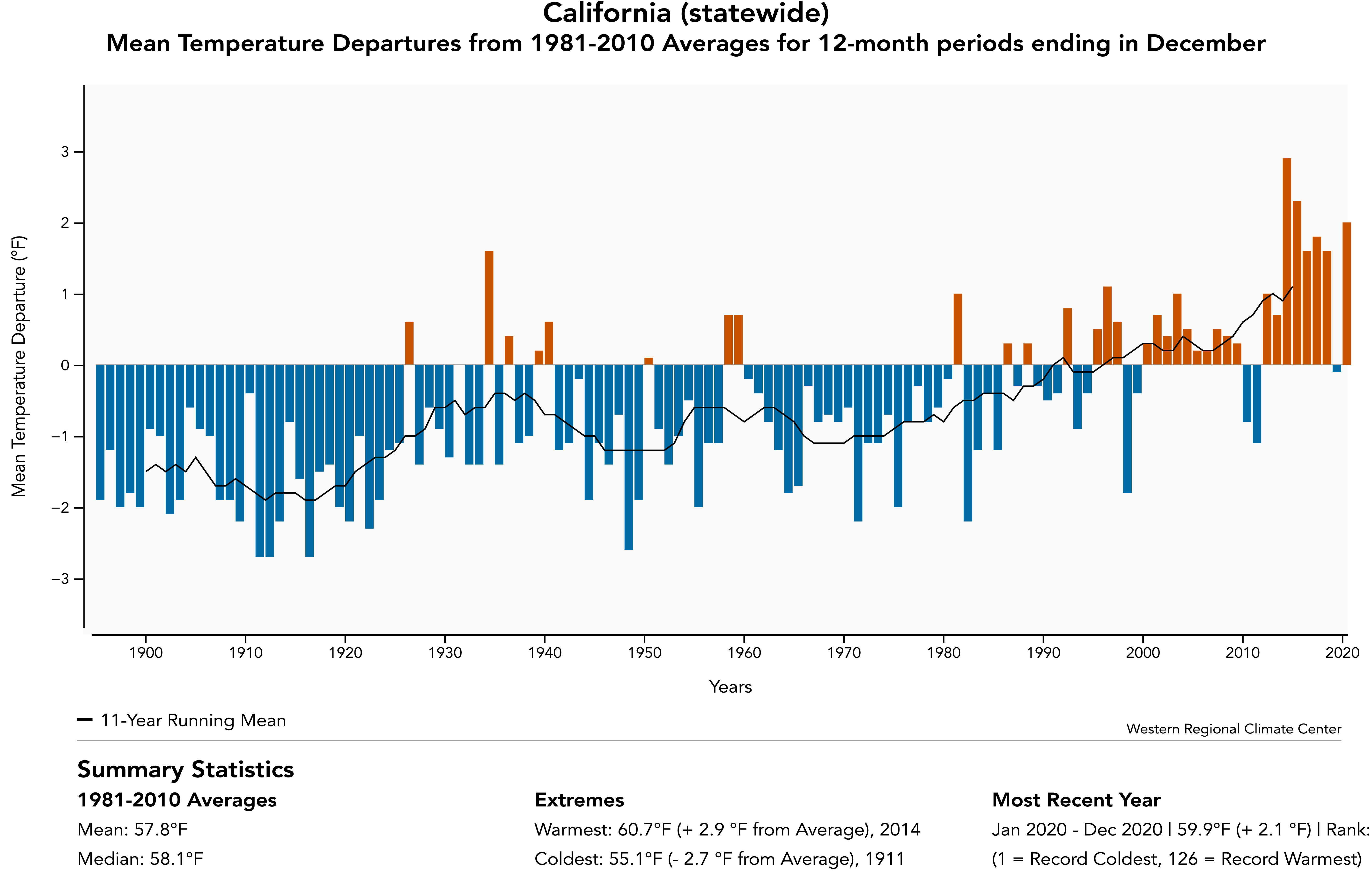
There wasn’t any record heat in California last year. California is in a temperature downtrend since the 1930’s.
“There wasn’t any record heat in California last year. California is in a temperature downtrend since the 1930’s.”
https://www.nbcbayarea.com/news/local/climate-in-crisis/climate-focus-bay-areas-hotter-temperatures/2484549/
 ?w=1024
 ?w=1024
“2020 was the hottest on record, following a series of four of the top five hottest since 2014. Average temperatures spiked highest vs. seasonal norms from late summer into fall, coincidentally the most dangerous time of year for fire season due to the gap in substantial rainfall from the previous spring.”
Where can I buy a mean temperature departure fahrenheit thermometer for my backyard? That’s where the mean temperature departure affects me.
The all time record temperature where I live in California was 108F in 1908. I wasn’t born yet, but I’m sure people were complaining then too.
I would be curious to see if higher lower temperatures were driving the higher mean temperatures.
Jim Steele has shown many times on here that california is not hotter than in the past
That is why you show the mean temperature, because it’s the nighttime lows that aren’t as cold.
Plus what you are showing undoubtedly is contaminated by UHI and serial adjustments all in step with co2.
At a guess
Pure climate Scientology
Heat waves in California are nothing new. What is certain is that the 5 million illegals living in California all want to live with air conditioning too. Since California has voluntarily refused to build adequate power plants to meet demand, power problems are the new normal.
Only an evangelist would ignore the role of cycles in order to leap to the case of historic, new trend and do so around the world with less and less perspective in each case.
griff,
You might try to read California’s official study findings as to what actually caused the problems last year. The #1 reason was poor planning – including not properly accounting for the fact that solar doesn’t deliver at the time of day that power demand peaks from 5 to 7 pm. Look up the “Duck Curve”. Do you see that it’s easily possible to plan for warming at the slow rate that is has been happening, little more than 1 degree C in a CENTURY (averaged throughout the year, but less in the summer than in the winter and less during the day than at night)?
You might consider a visit to a proctologist – you clearly have a bad case of Cranial-Anal Impaction.
It’s worse than that.
I recommend that he reach Down between his legs, grab his neck with both hand and give a sharp pull.
It can only help.
Re AGW attribution, have you checked the journals on this or these droughts? I would be amazed if there are no claims of an AGW probability contribution. They use climate models, so argue that paleo data is irrelevant, AGW being a new cause in the mix. Junk of course, but still needing careful counter arguments.
Did not. Thought natural variability as illustrated by Chaco Canyon sufficed.
Turns out it has been attributed to death. Even a study on media coverage of the attribution:
https://journals.ametsoc.org/view/journals/wcas/12/4/WCAS-D-19-0050.1.xml
That is media coverage of percentage attribution to AGW of the California drought. They at least point out that different researchers are getting different numbers. Pure junk.
I have been watching the fast growing attribution scam for a long time. The media loves it. There is a shop in Oxford U.K. that can produce one for an extreme event in days. Our NAS did a big report on attribution 5 years ago: https://www.nationalacademies.org/news/2016/03/attribution-of-extreme-weather-events-in-the-context-of-climate-change-new-report
They love it but the report include 40 or so pages on the problems, which I consider fatal. They just compare a computer model with and without AGW forcing.
My understanding is that under the Paris Accord each country is supposed to start reporting loss and damage due to AGW, which I expect to be huge. Have not seen that yet but it could make attribution a big industry. Or the countries may just attribute all bad weather to AGW. In either case damage claims may follow. Lawyers love big damages, right?
Came across this this morning:
https://phys.org/news/2021-06-western-drought-impacting-power-grid.html
Someone needs to get in there with some tub cleaner and elbow grease.
Not me, though. I did it last time.
But they WILL go dark because their Leftist governments want to punish their opponents.
In order to add to my collection of downvotes I shall point out that Lake Mead hydrological electricity production is already decreased by 25%. That hydro system is generating electricity which goes to Nevada, Arizona and California.
Original Post informs that the dead pool draw has become 950 feet and level is now 1,071 feet (it got as low as 1,081 feet in 2014). The 121 feet of water left now before reaching dead pool (1071-950=121) should be given more context – which is that the Bureau of Reclamation currently projects the water level to drop until November 2021.
Facts shouldn’t get you downvotes.
Most people can’t handle the truth.
Leftists aka Democrats simply redefine things to make themselves look good and others bad.
Air Quality is significantly better than in 1970, but because the limits have been changed WE ARE ALL GOING TO DIE!!!!!!!
Meanwhile:
Various shopping locations in Las Vegas are cooled by spraying water mist into the air to cool the general locale.
Various casinos using large water displays that change the local humidity.
Las Vegas golf courses and many other Nevada golf courses that affect downwind humidity.
Nor should one overlook that Arizona has their own golf courses to maintain.
And, alarmists run in circles screaming and shouting about the Lake Meade water level.
How many people will remain in Phoenix If the golf courses go to gravel?
You could see a day with sand courses, and you carry a chunk of astroturf to hit off of, and then oiled sand greens that I recall from my Saskatchewan youth.
Such courses require no water
An excellent article regarding the politics behind Ca water management:
https://journal-neo.org/2021/06/10/a-sinister-agenda-behind-california-water-crisis/
One thing is for sure. This year’s drought will deliver a repeat of all of the 2015 doom that spewed forth for years.
Even during the subsequent years when everything filled up out west. Like Texas has done is spectacular fashion rebounding from a drought year can be quite impressive.
“One thing is for sure. This year’s drought will deliver a repeat of all of the 2015 doom that spewed forth for years.”
That is absolutely for sure. The alarmists will blow this up into a horror story as much as they can.
They do it every time a drought forms and whine and cry until the rains come and shuts them up for a year or two. Then, a couple of years later, the drought comes again, and the alarmists whine again and claim it’s only going to get worse, and then the rains come again, and the alarmists shut up. It’s getting a little ridiculous for knowledgeable people.
The geological record says that western droughts of long duration are not uncommon. Lacking an adequate knowledge of why, there is always the possibility that the current one may be one of those lasting for a generation or two.
Funny (I guess it really isn’t) that Lake Meade keeps getting lower and lower. The intakes are going to have to be lowered. Can’t reduce the electric-generating/irrigation water-flow because S Cal and Las Vegas couldn’t stand it.
Lake Oroville Dam in California hydroelectric plant running needs that lake to have water at least equal to 640 feet and it is currently (June 2021 at 701 feet. This level is down 0.64 feet since the previous day. This same time last year (June 2020) the water was over 800 feet and similarly 2 years ago (June 2019) was over 875 feet.
Even a month ago California was projecting that 500,000 acres of land that is suitable for planting will just be left fallow this season. That does not address forthcoming issues farmers who have crops they are trying to manage will be dealing with as California’s summer progresses.
Original Post’s 3rd paragraph last sentence final word link about greening might have been better fleshed out some. Here’s that link’s relevant quote as a synopsis: [the greening cooling effect is mainly] “… due to intensive agriculture … and ambitious tree-planting … cooling …[effect] … only about 10-20% compared to pace … warming.” I am not attributing drought to CO2; whatever the impetus drought is significant.
Beng135.. it is not possible to lower the intakes on Hoover Dam… the intake towers sit on solid rock.The base of the towers is at the lowest altitude necessary to provide sufficient hydraulic head to spin the turbines at max efficiency.. The controllers at the power plant can open intake gates at any level of the 395ft tall intake towers
It takes a gallon of water to grow each and every almond in the CA Central Valley.
I think CA needs to decide if that’s the best use of an extremely limited resource.
What limited resource? There is exactly as much water on earth as there ever was. The fresh water resource is limited by management and nothing else. Guess who has been managing California since the 1970’s?
Even more when considering that hydrocarbon combustion (and cement manufacturing) liberates water in addition to CO2.
Water management has been a joke in CA. No disagreement there.
However, if you don’t think the resource is limited, I’m guessing you don’t live in CA.
We haven’t seen a drop of rain for at least 4 months where I live in Northern CA. The snowpack is already close to non-existent. And the major reservoirs are at half of their normal levels.
We certainly have a problem this year and even if the will and the funds existed, it will take many years to correct the under-investment in our water infrastructure.
Residential consumers who, of course, lack any powerful lobby will bear the brunt of the restrictions which have already been ordered by some water companies. Others will undoubtedly follow very soon.
For edification see the California Snow Pack map below, which is for 27 May 2021. It seems this year, that by April, the snow pack had melted significantly and some might phrase the remaining snow pack water as “extremely limited” in quantity.
All California reservoirs were full in 2019. Obviously, something happened to the water 18 months later. That’s no small amount of water. That’s the result of a California water management issue and nothing else.
I get something from eating almonds. It’s on the tip of my tongue. I know, joy.
And you rather wouldn’t drink a gallon of water instead.
The title is wrong according to the MSM! It’s not just a drought it’s a “MEGA DRAUGHT”.
MAGA drought 😉
“all its electricity will be green by 2030”.
It would be interesting to keep a running total of all countries (and/or states, in the USA) that have managed to reach this milestone, and publish it on the front page of this site somewhere.
What’s the total right now? Zero? Actually, come to think of it, I think I heard a claim that the ACT in Aus. is 100% powered by unreliable energy (which I’d be willing to bet needs a bit of wishful thinking to actually be true).
And on a related note, does hydro count as ‘green’, or not. I thought the CO2 from the vast amounts of concrete used in the construction of it disqualified it as ‘green’.
In California, hydro power is not counted as renewable power and is excluded from the total because it’s not “sustainable”. That makes it ungreen by definition.
That 50% water that gets released for environmental reasons wouldn’t even be available in the summer/fall if not for the efforts made by making the water available in the first place. Letting 50% of the water go to the ocean for environmental reasons is a real waste of fresh water, after having gone to all the effort to make it available for human use in the first place. Could probably pump some of that water in a circulating loop within the flatter river deltas and estuaries back upstream 5-10 miles, and reduce that 50% to 10%. There would always be new fresh water in the river delta and the flow could be supplemented by re-using some of that last mile fresh water for more flow volume upstream.
I would be all for exploring massive continental water diversion schemes such as the Rocky Mountain Trench pipeline bringing surplus water from northern Canada, the proposed James Bay Canal diversion pumping massive fresh water back to the Great Lakes, and diverting surplus Mississippi River water over the continental divide. You get a big chunk of the energy back pumping it up over the divide on the downside.
Other ideas include collecting fresh water in giant water bags from creeks and rivers draining into the ocean from the PNW/Alaska that a tug boat could pull and can be delivered anywhere along a coastal setting. The Medusa water bag would hold up to 2 million m3 of fresh water that floats on the ocean surface and could be towed via a tug boat to any coastal setting. Smaller versions have been tested, but acquiring export water rights is always the problem.
https://medusaenterprise.com/
There is no shortage of fresh water on the North American continent, just an impossibility to get real major infrastructure projects done. The Romans excelled because of their massive irrigation schemes around their empire. There is a major net gain to the economy and agricultural/industrial output of a society that does develop its water resources. California is a prime example of that, but would be impossible to develop that today from scratch.
Commercializing and privatizing bulk water exports would contribute massively to the future growth of the economy and support future population increase and stability.
I love to bring this one up with my Canadian Liberal friends, which causes their heads to explode, exporting water to thirsty jurisdictions that need it. Probably cheaper to desalinate at some point. Water and energy are the two things that that planet is not short of, if we want it.
https://en.wikipedia.org/wiki/Great_Recycling_and_Northern_Development_Canal
Mr. Newsom, tear down these dams!
Correct sentiment, wrong message.
Heartbreaking to travel central California in 2014 to see all the dying farmland. Enraging to hear then gov Moonbeam Brown blame farmers for the drought.
Some people in Kali are going to make a lot of money from this drought. For example, check out this 2019 article on the J.G. Boswell Company (BWEL). Since then the stock has doubled.
Then there’s the Resnick family, who uses more water than anyone else in Kali.
These are very savvy people who understand worth and timing.
Very helpful Rud, thanks.