Posted on March 1, 2020 |
Sea ice around Svalbard, Norway at the end of February 2020 is way above average, as the graph below shows – with more polar bear habitat now than there has been in two decades.

Some comparison charts below show that the graph above includes some very high ice years in the 1980s (reaching that dotted line above the mean) for which only global charts are available.
However, contrary to suggestions that more Svalbard ice is better for polar bears, there is no evidence that low extent of sea ice habitat in winter or summer over the last two decades harmed polar bear health, reproductive performance, or abundance. In fact, polar bear numbers in 2015 were 42% higher than they were in 2004 (although not a significant increase, statistically speaking) and most bears were found to be in excellent condition.
This suggests a return to more extensive ice to the Svalbard region in winter will have little impact on the health of the entire Barents Sea subpopulation, although it might change where pregnant females are able to make their maternity dens if ice forms early enough in the fall. In other words, the population should continue to grow as it has been doing since the bears were protected by international treaty in 1973.

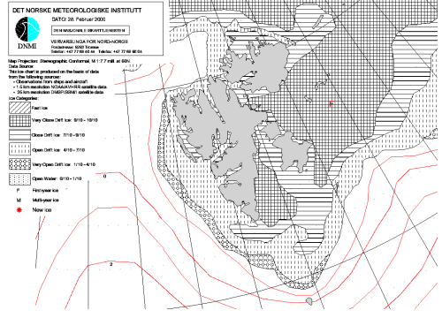
After substantial thick ice persisted into July last summer, at 28 February 2020 Svalbard is virtually surrounded by ice, as is Bear Island to the south (that little patch of grey at the bottom, surround by green and yellow) – the presence of pack ice invariably brings polar bears to Bear Island. There is substantial ice off the west coast (giving polar bears easy access to settlements there) and very close drift ice (red, 9/10-10/10 coverage) is dominant at both north and south ends, which was not true even twenty years ago, as I show below:

At 2019 for the same date, the ice was not quite as extensive or as concentrated, with open water between Spitzbergen and Nordaustlandet:
2017 was very odd, with a big patch of open water to the northeast of Nordaustlandet (the first and only time this has occurred in winter, as far as I know):

In 2014, so little ice reached south of Svalbard that Bear Island is left off the chart, which was also true back to 2008 (but the island came back to the maps in 2017):

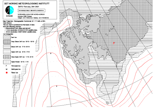
The year with anything close to the amount of ice as this year, at this date, in the Norwegian Ice Service record (which only goes back to 1997) was twenty years ago, in the year 2000 (see chart below). At the end of February 2000, Svalbard was completely surrounded by ice, with a thick band of ice off the west coast and much ice to the south, although the ‘tongue’ of open water extending north of Spitzbergen that has been characteristic of conditions for the last two decades was already present:
See 2020 below again for comparison with 2000 above. Notice that in 2000 the ice did not reach Bear Island and there was not nearly as much “very close drift ice’ as this year (cross-hatched in the chart above, red in the 2020 chart below), especially to the north and south of Spitzbergen. This year, that prominent ‘tongue’ of open water north of Spitzbergen is gone and there is highly concentrated ice between Spitzbergen and the large northeastern island of Nordaustlandet. Also, in 2020 the ice extends so far south it runs off the bottom of the chart beyond Bear Island:
By 2001 (below), a change in the pattern of sea ice during the winter that had been the norm in the 1980s and 1990s (discussed below) set in. From 2001 onward, there was less ice than usual by the end of February and/or less concentrated ice, especially on the west coast and north of Spitzbergen. While this year’s pattern is a stark reversal of that trend, it will be a few years before we can tell if this is another shift or just yearly variation.
For the period 1979-2020, polar bear habitat around Svalbard at this time of year was probably at its most extensive in 1979, as the NSIDC chart for February shows (below, where the magenta line is the 1981-2010 mean), even while ice in the Bering Sea was below average (more on that in another post):

In the 1980s, Svalbard ice varied up and down but generally above the long-term mean (see 1986 below, for example):

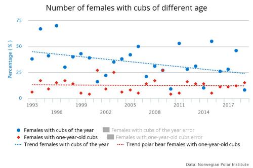
Polar bear health and reproduction values are only available in detailed form back to 1993 but there is not much difference between the 1990s and the 2010s (see graphs below, but also see Larsen 1972; Wiig 1998). The number of females with one year old cubs (mortality is always highest in the first few months and these surveys are done in April, just after mothers with new cubs emerge from their birth dens) has not changed:
Nor has the weight of adult males changed over this period:

What has changed is the number of females able to make dens on the islands of the west coast of Svalbard (see graph below).
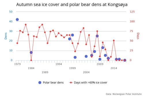
Most polar bear females that once routinely made their maternity dens on the eastern islands of the Svalbard archipelago (see map below) now den on the sea ice to the east and north of Svalbard, on the ice around the archipelago of Franz Josef Land, or on the islands of Franz Josef Land itself (Aars 2015, 2018; Aars et al. 2009, 2017; Andersen et al. 2012).

Aars and colleagues found only about 200-250 bears were loyal to the immediate Svalbard region in 2015 (Aars et al. 2017). During 2004 population survey, Aars and colleagues (2009) found about three times more bears in the Russian sector of the Barents Sea than around Svalbard (for a total estimate of about 3,000 bears). This fact is the basis of my suggestion that the 2015 survey that was limited to Svalbard (Aars et al. 2017) could plausibly be extrapolated to give a population estimate for the entire Barents Sea of about 3,750 at 2015 (Crockford 2017, 2019, 2020), still not a statistically significant increase given the methods used.
If Svalbard sea ice habitat continues to vary in the future as it has since 1979, there is no reason that Barents Sea polar bear population growth will not keep on going.
References
Aars, J. 2015. Research on polar bears at Norwegian Polar Institute. Online seminar (‘webinar”), January 14. pdf here.
Aars, J. 2018. Population changes in polar bears: protected, but quickly losing habitat. Fram Forum Newsletter 2018. Fram Centre, Tromso. Download pdf here (32 mb).
Aars, J., Marques, T.A., Buckland, S.T., Andersen, M., Belikov, S., Boltunov, A., et al. 2009. Estimating the Barents Sea polar bear subpopulation. Marine Mammal Science 25: 35-52.
Aars, J., Marques,T.A, Lone, K., Anderson, M., Wiig, Ø., Fløystad, I.M.B., Hagen, S.B. and Buckland, S.T. 2017. The number and distribution of polar bears in the western Barents Sea. Polar Research 36:1. 1374125. doi:10.1080/17518369.2017.1374125
Andersen, M., Derocher, A.E., Wiig, Ø. and Aars, J. 2012. Polar bear (Ursus maritimus) maternity den distribution in Svalbard, Norway. Polar Biology 35:499-508.
Crockford, S. 2017. Testing the hypothesis that routine sea ice coverage of 3-5 mkm2 results in a greater than 30% decline in population size of polar bears (Ursus maritimus). PeerJ Preprints 2 March 2017. Doi: 10.7287/peerj.preprints.2737v3 Open access. https://doi.org/10.7287/peerj.preprints.2737v3
Crockford, S.J. 2019. The Polar Bear Catastrophe That Never Happened. Global Warming Policy Foundation, London. Available in paperback and ebook formats.
Crockford, S.J. 2020. State of the Polar Bear Report 2019. Global Warming Policy Foundation Report 39, London. pdf here.
Larsen, T. 1972. Norwegian Polar Bear Hunt, Management,and Research. Bears Their Biology and Management 2: 159-164.
Wiig Ø. 1998. Survival and reproductive rates for the polar bears at Svalbard. Ursus 10:25–32.
What a world of conflicting wishes. It appears that the authors are hoping for more ice and more polar bears. The people that produce those Great White Shark videos are hoping for warmer oceans and more sharks. Are both hoping to film bears/sharks eating people? I personally intend to avoid either scenario and, wait for it, take vacations that follow good golfing weather.
Very informative!
Thx!
If 42% is not statistically significant you must have some pretty lousy stats !
In the last graphic I misread the label as “polar bear dinning area” . I suppose the dinning area mush be just outside the tourist buses.
Actually there are tourist guides in Longyearbyen which takes tourists on expeditions into this area with dog-sleds in spring to photograph polar bears in their natural habitat. A friend of mine went a couple of years back. He was a bit grumpy though, since many bears had numbers painted on them (that’s how they know how many there are).
It is not particularly risky, though they of course go armed at all times. At this time of year the bears are well-fed, and polar bears are not at all aggressive towards humans like e. g. grizzlies. Don’t go too close to females with cubs though. And be very careful in autumn-early winter when the bears are hungry!
Counting polar bears is a tricky thing. It’s hard to get them to line up and sound off.
Helicopters and trank guns.
https://www.worldometers.info/coronavirus/covid-19-testing/
Barents Sea population is estimated between 2500 & 3000 bears. so a 42% increase is around 1200 bears. Definitely not Insignificant for the specific area though only around 5-6% of the global population.
A much better showing though than Renewable (Solar/Wind) proliferation
It’s times like this I miss our Griff!
Not at all, 😀
SHHHHH
He’s like Lord Moldywart, You utter his name and he pops in
Webcam from the Zeppelin mast at Nyålesund in NW Svalbard:
The whole inner part of Kongsfjorden is frozen – very unusual.
Wow, tty, that’s gloomy….
It’s better in summer, but it’s not exactly Malibu Beach even then.
Article excerpt:
Most humans don’t even know what’s best for themselves, ……. and they damn sure don’t know what’s best for Polar bears, …… even many of those who claim to be PB “experts”.
If our early human “hunter-gather” ancestors had to search hundreds of square miles of fields and forests just to hopefully find enough nourishment to cure their hunger tantrums, ……. the H sapiens species would have never evolved to what it is today.
Ten (10) potential meals of “seal pups” distributed over one (1) square mile area of sea ice ……. is far, far better for a hungry Polar bear than is …… one (1) potential meal of a “seal pup” located somewhere within a ten (10) square mile area of sea ice.
From this particular area (Svalbard) there is quite a lot of historical data quite far back (from 1596 as a matter of fact). The sea-ice today is more extensive than on the same date in most years in the 1930’s and similar to conditions in the 1950’s and 60’s:
http://www.climate-cryosphere.org/resources/historical-ice-chart-archive/quicklooks
Note that 1979 (the beginning of history for IPCC) was a very extreme ice year.
“The sea-ice today is more extensive than on the same date in most years in the 1930’s”
There is the very warm 1930’s popping up again. It pops up in all sorts of records.
Willem Barentsz landed up on the northwest corner of Svalbard in 1596 in mid June. I noticed that in mid June last summer he could not have landed at the same spot. This was a handy factoid to have, when dragged into one of those silly arguments, that certain people who never bother look at history start.
There is a northern tendril of the Gulf Stream that curves back, from off the south coast of Norway, and sneaks into the arctic on the east side of Fram Strait. That is what melts the ice on the west coast of Svalbard, and sometimes even north of Svalbard. When a west wind blows sea-ice across Fram Strait from the far colder west side the ice can vanish (from satellite views) with astonishing speed on the east side of Fram Strait. However, to get up to Svalbard, this tendril of warmer water must cross a vast expanse of ocean exposed to the ferocity of North Atlantic Gales. This year the gales have been especially ferocious and the howling winds have been from the cold north more often than in the recent past. I can’t help wonder if the tendril has been chilled and churned to a degree where it will melt ice less, on the west coast of Svalbard.
Yes, I noticed on the ice-maps that Svalbard is both surrounded by ice and very cold this winter. Bering Sea off of Alaska very cold & icy too.
Thanks Susan.
While being of the USA, I have never been good at “place name geography” — college training in the subject goes a different direction – and that I have. Anyway, I have an old globe (one should be in every house) so I had a look at Svalbard & Spitsbergen. Using the globe is useful when contemplating these places. Looked on the web for an image that conveys the same vision. None. I did find this interesting photo –
White bear & a white hat ?
Also, “I searched it up” as the young folks say. From Wiki:
Under Norwegian governance, the archipelago was named Svalbard in 1925, the main island becoming Spitsbergen. By the end of the 20th century, this usage had become common.
That’s definitely not Svalbard. Here is the tallest “tree” in Svalbard:
Past Weather in Longyearbyen
https://www.timeanddate.com/weather/norway/longyearbyen/historic
That is definitely colder than average for the time of year.
From most of the sea ice maps, it seems like there is open water along the west coast of Svalbard in most years, while there is consistently more sea ice to the east, where the polar bears prefer to have their dens. If there is more ice than usual to the west this year, there could be an increase in polar bear population there this spring.
Already happened:
https://www.highnorthnews.com/nb/matte-avlive-isbjorn-som-feiret-romjul-og-nyttarsaften-midt-i-longyearbyen
The comment by the WWF gal is telling:
Since the polar bears are under stress from climate change, it would have been better to tranquilize it and relocate it somewhere else.
This is par for the course in the eco fascist explanation for more polar bear availing themselves of garbage dump food throughout the Arctic: they’re starving because of climate change. Not they’re loads of them and human garbage is easy pickings.
How to twist the story.
boy, talk about ‘cherry picking’: one town in Norway. conclusion: problem solved!
sheesh
Exactly, Like One tree in Yamal
One Tree to rule Yamal
One Tree to find them
One Tree to call Yamal
And in Climate Science Bind Them
Reporting on changes in ice behaviour and bear population isn’t cherry picking.
Coronavirus.
I’m convinced arctic sea ice extent is dictated by chinese power plant pollution.
TTY,
Who ever told you that? “not at all aggressive towards humans like e. g. grizzlies.” Don’t listen to him. I’ve worked up there. If a polar bear sees you, HE OR SHE WILL TRY AND EAT YOU! Not at all like grizzlies, that have often seen people, and tend to be shy. i worked in the Arctic off and on from the ’70’s to the ’90s in the oil industry. No one could travel from the camp to the drilling rig unless in a vehicle, and a polar bear sighting was a “red alert”. A bear inside the camp perimeter was considered an emergency. ie. no one to be outside. If you ever travel to Churchill Manitoba to see the bears, ask the locals. https://www.google.com/search?q=POLAR+BEAR+SAFETY+SIGNS&rlz=1C1GCEB_enCA838CA855&oq=POLAR+BEAR+SAFETY+SIGNS&aqs=chrome..69i57.11996j0j9&sourceid=chrome&ie=UTF-8
“Who ever told you that?”
Nobody. Personal experience.
I’ve met quite a few Polar Bears in Svalbard. And, yes, they are potentially quite dangerous, and, yes, you always carry a gun when outside Longyearbyen township, but I’ve never used one, and I’ve never met anybody who has had to use one either.
And, yes, I know about the english tourist killed a few years ago in Svalbard. And there was another case in the seventies if I remember right. Hardly a horrific record.
Agh. Wrong link. Have a look at this one. There is a link to the video script. http://www.bearsmart.com/play/safety-in-polar-bear-country/
STAY AWAY FROM POLAR BEARS!
Note that I have ammended my post to reflect a tweet by the NIS that *2004* was the last time there was as much Svalbard ice as 2020 on 28 Feb. https://twitter.com/Istjenesten/status/1233391529626087424
As I discussed, clearly 2000 had less ice than this year but somehow I missed 2004 in the archive. Oversight corrected.
Susan
The east side of Svalbard has the ice, while the west has a warm current and open water. Way back in 1596 Willem Barentsz found open water on the northwest corner and landed in mid June, when sea-ice usually hasn’t melted back all that far. He could not do the same landing last June.
Currently sea-ice extent is at higher levels than the past five years, and temperatures at the Pole are at the lowest level of the winter, and below normal.
https://sunriseswansong.wordpress.com/2020/03/03/arctic-sea-ice-a-wrap-around/