First ever study of how North America’s four main weather regimes are affected by polar vortex strength

The four US weather regimes (clockwise from top left): Pacific Trough, Arctic High, Alaskan Ridge, Arctic Low. Red indicates warmer conditions and blue colder conditions
Credit: Simon Lee
Winter weather patterns in North America are dictated by changes to the polar vortex winds high in the atmosphere, but the most significant cold snaps are more likely influenced by the tropics, scientists have found.
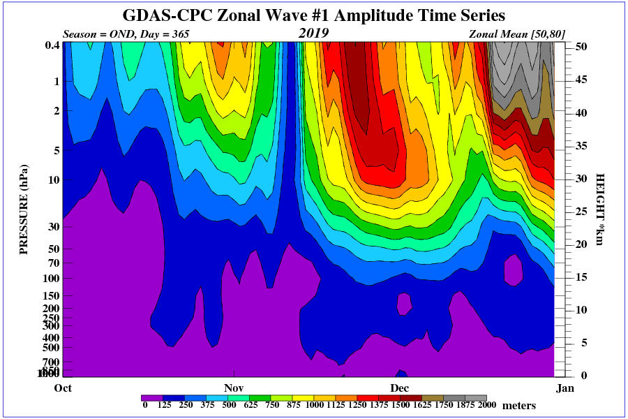
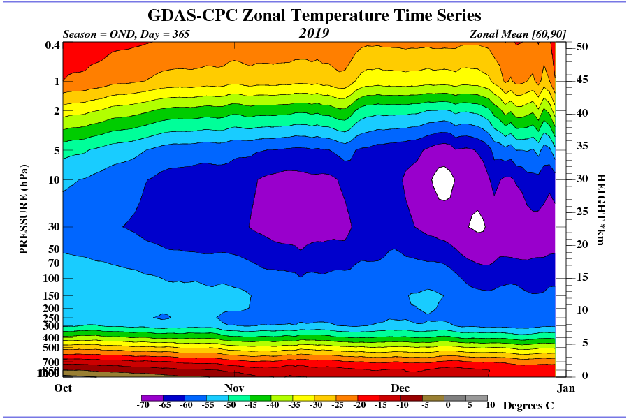
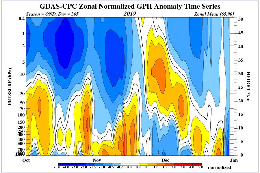
A team led by the University of Reading conducted the first ever study to identify how the four main winter weather patterns in North America behave depending on the strength of the stratospheric polar vortex. This is a ribbon of wind and low pressure that circles the Arctic at heights of 10-50km, trapping cold air inside.
It is already well established that the vortex wind strength influences weather in Europe and Asia, and the study revealed it also has a strong effect on three out of the four main winter weather patterns in North America, giving forecasters an additional tool to understand potentially high-impact weather during winter.
The study, published in Geophysical Research Letters, also revealed that, unlike in Europe, the most extreme cold snaps affecting the whole of North America are not most likely to occur after a weak vortex. Instead, the shape of the vortex and conditions in the tropics were identified as stronger influences of these conditions.
Simon Lee, atmospheric scientist at the University of Reading and lead author of the study, said: “Despite the most extreme cold snaps experienced in North America often being described as ‘polar vortex outbreaks’, our study suggests vortex strength should not be considered as a cause.
“We know that a weakened polar vortex allows cold air to flood out from the Arctic over Europe and Asia, but we found this is surprisingly not the case the other side of the Atlantic.
“In fact, our work suggests we should actually look south to conditions around the equator, rather than north to the Arctic, for the causes of these widespread freezing conditions in North America.
“Our results did reveal that the polar vortex strength provides useful information on the likelihood of most weather patterns over the US and Canada further in advance, including some potentially disruptive temperature changes or heavy rain. The more accurate information populations have about upcoming changes in weather, the better they can prepare.”
One of the clearest suggested effects of a strong vortex was a 10-15% likelihood of extremely cold conditions in western parts of North America, including Alaska, but milder conditions in central and eastern parts of the US.
Another weather pattern found to most often follow neutral or strong vortex wind speeds brings temperatures 5°C above normal and wetter weather in the eastern US.
The exception in the results was that the weather pattern associated with the highest chance of the most widespread extreme cold in North America, in which average temperatures in the central US are more than 5°C below normal, was not found to have a strong dependence on a weaker vortex, as it does in Europe.
They found widespread extreme cold is more common when an area of high pressure extends up to Alaska, and the polar vortex stretches down towards North America – pushing cold Arctic air southward in the lower atmosphere.
The scientists say the influence of the stratosphere on weather patterns, as well as how this interacts with long-term weather patterns in the tropics like El Niño, should be studied further and incorporated into forecasts to improve their accuracy.
###
That article didn’t really give me much insight into how the climate works.
It’s probably true that the coldest winters in the U.S. are when a high pressure system sits up around Alaska which has the consequence of directing cold arctic air down into the United States.
I think the question is why does this high pressure system establish itself here.
re: “I think the question is why does this high pressure system establish itself here.”
Let’s start with what’s known: ‘Descending air’ in the middle of a high pressure system.
It can’t give any insights how climate works, because the study is about US winter weather
Krishna the data covers 1979-2017. Dominant winter weather patterns for almost 40 yrs are climate.
“The scientists say the influence of the stratosphere on weather patterns, as well as how this interacts with long-term weather patterns in the tropics like El Niño, should be studied further and incorporated into forecasts to improve their accuracy.”
The data may cover a climate periode, but the study refers to weather prediction possibilities
“Weather” is reigned by the quasi biennial oscillation, too – and that genuinely is “Climate”:
https://www.google.com/search?q=quasi+biennial+oscillation&oq=quasi+bi&aqs=chrome.
It is difficult to say “we don’t know” in so few words.
Curious George
HeHeHe……Wkd. 🙂
As Joe Bastardi of Weatherbell Analytics– the Madden Julian Oscillation describes the process. It essential starts with Indian Ocean dipole moment and thunderstorms releasing enormous amounts of heat in the upper stratosphere forming the Artic Highs.
Historical analogue information has been known for years to cause cold Winters. This December warmth is a prelude to a very cold Jan-March this year.
As new subscriber to Weatherbell Analytics that is what Joe has suggested. If I’m wrong in that assessment and your out there Joe please correct my evaluation.
Totally agree. JB has provided a lucid explanation of how the winter season will evolve the way you stated… see the Saturday Weekly summary (free) at Weatherbell.com… excellent stuff. JB is ruthlessly honest about delusions on both sides of the climate debate, and is just as tough on himself when his predictions fail (and why they failed).
Joe has a wonderful ability to remember similar maps from the past, but a computer can bring up analog maps. What Joe also recalls is the motion in the map. A map of a ridge and a trough is a static thing. Joe remembers if the ridges and troughs were digging or lifting.
Me? I make a wild guess and then sit back to see how wrong I can be.
It has recently been interesting to watch how the cold built at the Pole and especially in Alaska and the Canadian Archipelago the moment the flow around the Pole became quasi-zonal.
https://sunriseswansong.wordpress.com/2019/12/28/aectic-sea-ice-slack-tide/
This justifies a return to my old hypothesis set out here:
https://www.newclimatemodel.com/is-the-sun-driving-ozone-and-changing-the-climate/
whereby jet stream waviness is a consequence of the interaction between a top down solar effect above the poles and a bottom up oceanic effect from the tropics.
The result of more such waviness is increasing extreme episodes of both warm and cold but overall increased global cloudiness that eventually cools the whole climate system.
Stephen,
I read the explanation for your theory for the first time several years ago. It makes complete sense to me.
Hi Mike,
It makes sense to a lot of people but those who ought to be investigating the concept are simply ignoring it.
Not convenient, politically.
When I read “first ever study of”… is my feeling, it didn’t worth a study.
…something weather forecasters have known for decades
So, given that most of the atmosphere is below the polar vortex why would it have much influence on the weather?
Is it possible that conditions in the troposphere influence the stratosphere and not vice versa?
Because the temperature of the lower stratosphere over the poles affects the height of the tropopause over the poles and thus alters the gradient of tropopause height between equator and poles.
Changes in that gradient affect Jetstream behaviour and overall global cloudiness.
Weak sun activity with less UV radiation lets shrink the atmosphere.
(TCI)
That relies on the quirky climate science definition of “atmosphere”. If you look at this years SWAN instrument paper you will see Earth hydrogen molecules extend 640,000 Km into space way past the moon. So you could say that it the atmosphere boundary.
Probably stick to the name you are talking about which is the thermosphere, and leave the word atmosphere alone.
At spaceweather.com you find an explanation of the TCI and the data too.
Krisna I am wondering if the weird high speed jet streams are a consequence of the sun being quite. The other question that comes to mind is did this happen before the LIA??
Since North America is surrounded by copious amounts of warm water in the winter on its southern flank (Pacific off California, the Gulf of Mexico and the Atlantic south of Cape Hatteras), all you need to do is get the winds blowing in from the southwest, south or southeast to hit the arctic air coming in from the north and bingo, you can have Snowmaggadon.
I’m not so sure many people living in North America don’t know this already. It happens once or twice a winter.
Of course the weather is influenced by the tropics. That’s the weather-engine that drives all the other “parts”, all the way to the poles.
Svensmark’s attempts to sell GCR affects on the earths albedo (cloudiness) seems to revolve around Willis Eschenbach’s Equatorial Convergence zone. I started following the https://wattsupwiththat.com/2007/10/17/earths-albedo-tells-a-interesting-story/ (Great Bear Observatory) work years ago, and it seems that the basic science is still not confirmed.
Alarmists still say the solar radiation changes cannot explain climate, but they refuse to accept the amplification effects provided by cloud formation.
And the changing UV radiation during solar cycle affecting the ozone layer, the temperature of the thermosphere…
. . . because that is where the greatest energy is.
“..our work suggests we should actually look south to conditions around the equator….for the causes of these widespread freezing conditions in North America.”
What a crock! These people just think the tax paying public is dumb enough to fund their “research”…
I had a very frustrating conversation recently with a self-described climatologist and IPCC reviewer. I tried to explain why the climate models could never work but they wouldn’t listen. They just kept repeating that the models simply followed the rules of physics. So the answer to this issue is remarkably simple: just look at the climate models’ runs from just before these temperature patterns appeared and the models will (a) show the temperature patterns as just experienced, and (b) explain why they occurred.
Either that, or the models really will never work.
Oh they’ll work, but not for a long, long time.
For understanding the movements of atmosphere, read Marcel Leroux ! His Mobile Polar Anticyclone explains why North America can be frozen, not an alledged “vortex”.
Leroux was referring to the tendency of northern high pressure regions in the troposphere to drift equatorward taking cold air with them.
That is consistent with my hypothesis concerning changes in the gradient of tropopause height between equator and poles.
You will note that changes in the stratospheric polar vortex (which contains descending adiabatically warming air that depresses the tropopause over the poles) can facilitate the equatorward drift.
“Leroux was referring to the tendency of northern high pressure regions in the troposphere to drift equatorward taking cold air with them.”
I think that describes what we see. High Pressure systems drift around unless acted upon by an outside force. Sometimes high pressure systems practically stop over one location for a period of ttime..
These Leroux MPH are mostly small ones at a very low hight.
Not at all: they could be hemispheric sized MPHs.
They could, yes, but Leroux’ observatios found a lot of small ones too over days and weeks. That’s the base of his work.
The oceans have tremendous thermal inertia ……….having stored massive amounts of heat from solar energy of previously active periods of the sun…………..which is still coming out after the sun has morphed to being less active.
This lag between the peak in heating of the oceans from the sun and when the oceans burping out that heat is exhausted is probably, at least a decade.
Indeed. The “Polar vortex weakening” supposedly “permitting cold air to escape the polar regions” cannot be based on factual observations. Synoptic analysis of satellite imagery shows cold air masses in the lower troposphere constantly move from the polar regions toward the tropics, regardless of the season.
Using averages tends to obliterate the real working of circulation hence those “Azores anticyclone” types of so called action centers. Observing circulation at work is truly the first order of business for anyone.
Here’s what the jet stream looks like today according to Nullschool:
https://earth.nullschool.net/#current/wind/isobaric/500hPa/orthographic=-101.92,51.66,660
The jet stream is taking a deep dip into the lower United States.
The good part about the jet stream dip into the lower U.S. is it is bringing in tropical air off the Pacific ocean, not arctic air.
Which accounts for the snow the last couple of days in my neck of the woods. And yes Virginia it does snow in the high altitude areas of Arizona.
chemman, yes, it does and the White Christmas was lovely!
I’m in the loop that has dipped down through the Rockies. There is little wind but I woke to a few inches of white stuff this morning, just enough moisture being brought up from the south to be frozen out by the northern cold.
European MSM making a lot if the lack of snow in Moscow, because, of course, climate jitters. That it all seems to have gone to Minnesota is not mentioned, of course.
@Krishna Ghans: When I read “first ever study of”… is my feeling, it didn’t worth a study.
@Lititude: “…something weather forecasters have known for decades”.
Very true!!
It again shows how peer review works for some particular group of climate scientists. Actual innovative research from true scientists will suffer a long delay and most of the time will be rejected; whereas silly and known ideas are getting published so quickly in renowned journals.
I start with the fact that it comes from EurekAlert! and proceed to the fact that it is research conducted at the University of Reading, before concluding with this question. Are they just correlating weather outcomes with stratospheric conditions and assuming causation? If the same “study” is repeated with next year’s conditions, will it contradict what “we know”? Null hypothesis anyone?
I start with the fact that the study covers 1979-2017, not just one year.
Ok, substitute the next four decades for next year if you like, it doesn’t touch my point.
Are they inferring causation from correlation, or aren’t they? The reason I ask is that they claim to “know” that polar vortex causes cold events in Europe, but “surprisingly” not in North America. No hypothesis about the physical mechanism involved or what should be different in the North American case. If there is a physical process that is responsible for the correlation they discovered, why would the process not be applicable everywhere at the same latitude?
So that sounds a lot like the rooster crowed and then the sun came up, therefore sunrises are caused by rooster crowing (on the farm). Then we checked a place with no roosters, and “surprisingly”, the sun still came up. Apparently in those areas, song birds chattering are more responsible for sunrise. However, in a few cases we observed alarm clocks having a strong effect.
It is a matter of geography.
Arctic high pressure regions with their associated cold air can easily slip eastwards and southwards across the continental land mass to the east of the Rockies but such regions forming west of the Rockies cannot easily propagate eastwards so they tend to move southwards and are easily dissipated by warm Pacific waters to the south. Water has a hugely greater heat capacity compared to air.
As always, a knowledge of basic meteorology provides answers.
What part of that involves a mechanism that depends on the stratosphere? And is that their hypothesis, or just yours? Your explanation can be perfectly correct without their correlation being a reflection of any physical reality.
The temperature of the stratosphere above the poles influences tropopause height above the poles and thus the likelihood of equator ward surges of cold higher pressure air in the troposphere.
“Waiting on the Polar Vortex” sounds like a song title.
Those of us that live in the real world have to prepare for sun, wind, rain, snow, and cold well in advance of any forecasts.
When you have outside animals you best should fix the frost-free faucet and the heater on the water tank, and not wait until the researcher models claim it might get cold.
Same with firewood, snow tires, and a warm coat. October, in the NH, is a good time to get these things done.
The distribution of ozone in the stratosphere and the associated polar vortex pattern depend on the strength of the geomagnetic field and the solar magnetic field. When the solar wind weakens, the polar vortex pattern follows the geomagnetic field pattern in the north.
http://sol.spacenvironment.net/raps_ops/current_files/Cutoff.html
https://www.esa.int/Applications/Observing_the_Earth/Swarm/Our_protective_shield
Another stupid question: does the position of the magnetic pole have any affect on regional temperatures at all?
Currently, a strong wave is operating in the upper stratosphere, which results from the weakening of the stratospheric polar vortex by one-sided inflow of ozone to the polar circle.
The wave from the upper stratosphere eventually moves into the troposphere, directly affecting the weather.
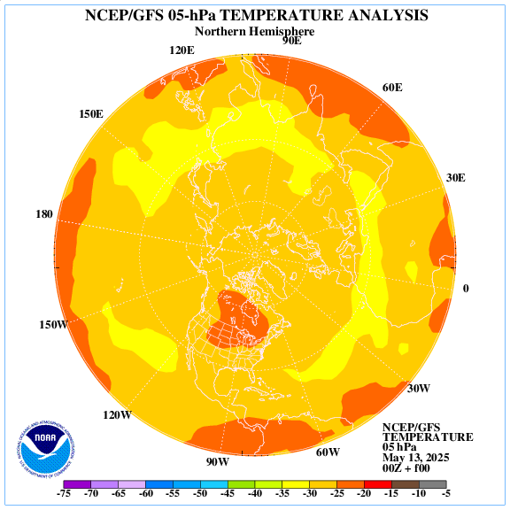
It will be on around 8th Jan in central US, an elongated High from Canada to the gulf coast with deep cold in the NE pulled down to the GOM.
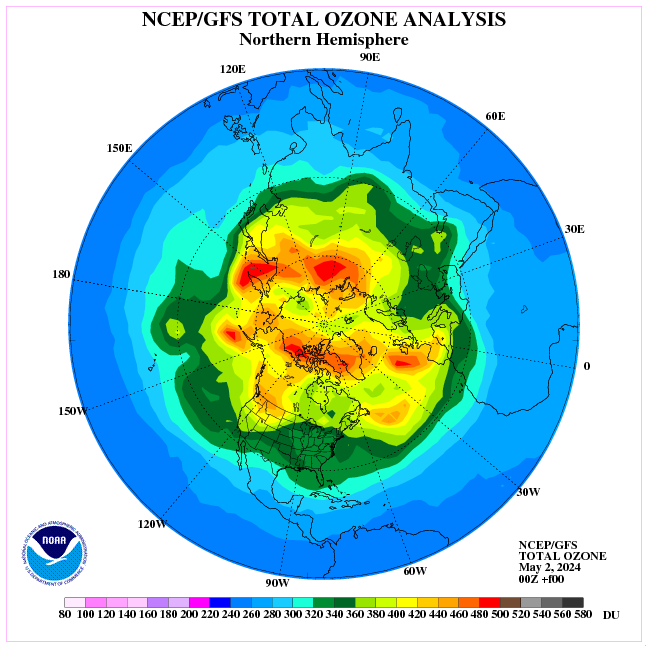
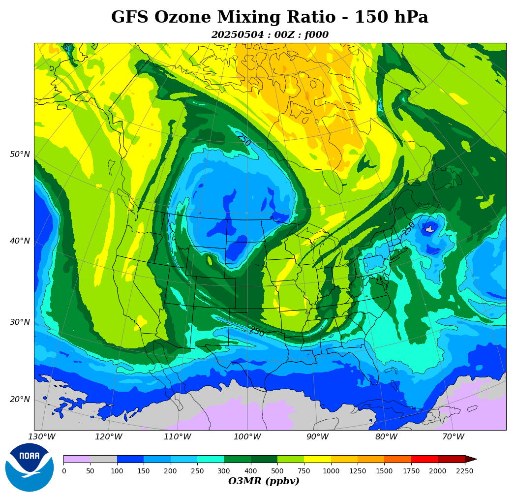
This is now the distribution of ozone in the north.
I found this article on the sun’s effect on the Jet Stream very interesting. I would be interested in thoughts on this.
“Meridional Jet Stream” Upsets Europe’s Apple –and Pear– Cart
http://bit.ly/2ZVxp2B
August 8, 2019
Europe is forecasting a sharp reduction to its apple and pear crop this season after a long-lasting spell of Spring cold followed by a brief (but much-documented) burst of July heat dealt production regions something of a one-two punch — yet another example of the Swings between Extremes brought on by a wavy jet stream, which itself is associated with historically low solar activity.
…Furthermore, some regions of the planet actually warm during times of global cooling — the Arctic, Alaska and N Atlantic/S Greenland to name a few (though ‘warm’ to the Arctic, for example, still averages well-below zero, there is no additional melt):
Temp change between 1780 (a year of normal solar activity) and 1680 (a year within the depths of the Maunder Minimum) — NASA
Earth’s climate is cyclic, never linear — driven by the sun.
And history is repeating, our star is again shutting down (relatively).
The SSW, which is already visible in January, may once again prolong the waves of frost in Europe until April.
Currently, an anomaly of stratospheric ozone over western US is visible.

The 2 MSM companies that control 80% of news publications in New Zealand are making big over a warm marine blob centered ~ 2000 km off our east coast. They then go on about tropical fish having been observed further Sth than ever and publish comments from the most extreme alarmist scientist in NZ. They make no mention of the cold trend surrounding the country.
This cold zone has been creeping north and intensifying over the last month. Balanced journalism would surely discuss both phenomenon. The US and Australia have media that balance the debate, but NZ has none. We are now subjected to daily sermons with no means of reply.
M
Snow coming from the Tropics…..Heh, Heh,…..maybe that’s something we should be looking out for in Queensland next winter.
Snowmageddon again? Yeah, we had that last winter and this time, deep cold and snowy winter is keeping itself out of my AO. And it can stay out! I don’t want to shovel snow this winter!!
For the tropical connection, this left off 3 very important words – Madden-Julian Oscillation…
Ozone is a good tracer, as it defines the boundaries of cold air parcels like the polar vortex, an ironically good use for a trace gas 50-200X less concentrated than CO2; but it’s not a good basis for a climate theory, nor is the thermosphere, neither control the ocean temperature or the tropics.
but it’s not a good basis for a climate theory, nor is the thermosphere, neither control the ocean temperature or the tropics.
Agree.