Guest by metaphor mixing by David Middleton
Right after geology & geophysics, my favorite hobby is military history, particularly that of the U.S. Navy and Marine Corps. The constant whining about Kiribati being washed away by carbon-fueled sea level rise inspired me to employ geology and military history in a combined offensive against the sea level rise “crisis”.
Anyone else fed up with crap like this?
[…]
So the world kept getting hotter. The global community sailed past the 1.5 degree Celsius “‘safe’ threshold of warming” mark around 2038, and summers of Saharan intensity became an annual norm in Europe—often in North America, too. These extreme bouts of heat—too routine now to be dubbed “heat waves”—claimed annual death tolls of thousands in many countries, while wildfires courted the specter of mass famine by burning up billions of dollars’ worth of cropland. Around 80 percent of Earth’s coral reefs died off, tanking fishing and tourism economies around the world. The ocean rose about 1.5 feet, exposing an additional 69 million people every year to regular extreme flooding. Residents of the tiny Pacific island nation of Kiribati, which sits an average of a little less than six feet above the precrisis sea level, began to flee to Australia and New Zealand en masse.
The world’s population ballooned to 12.6 billion by the end of the century, and Earth’s temperature rose by 4 degrees Celsius—twice the level that scientists…
[…]
Today, at 4 degrees, there is still civilization. But there is no Kiribati, given that sea levels have risen three feet since the beginning of the century. Most of the nation’s 110,000 people have fled to Australia and New Zealand—both of which are struggling with climate-driven scarcity in their own economies, and reverting to uglier forms of discrimination from their shared colonialist past. Australia has continued its practice of housing migrants in inhumane offshore detention centers in Papua New Guinea—except now, drought has dried up the rainwater tanks that supplied New Guinea’s drinking water, and salt water from the rising sea has leached into the soil, further decimating agricultural production on the island.
And Kiribati is but one snapshot of the new global normal.
[…]
The New Republic
Kiribati…
Kiribati (/ˌkɪrɪˈbæs, -ˈbɑːti/),[8] officially the Republic of Kiribati (Gilbertese: Ribaberiki Kiribati),[1][3][9] is a sovereign state in Micronesia in the central Pacific Ocean. The permanent population is just over 110,000 (2015), more than half of whom live on Tarawa Atoll. The state comprises 32 atolls and reef islands and one raised coral island, Banaba. They have a total land area of 800 square kilometres (310 sq mi)[10] and are dispersed over 3.5 million square kilometres (1.3 million square miles).
Wikipedia
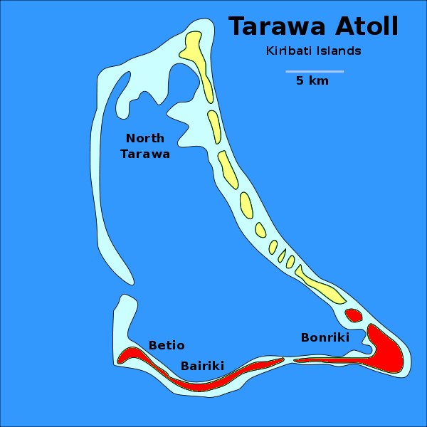
While Kiribati comprises a whole lot of islands, the main island group is Tarawa Atoll.
Geography
Wikipedia
Location Pacific Ocean
Coordinates 1°20′N 173°00′E
Archipelago Gilbert Islands
Area 500 km2 (190 sq mi)
Highest elevation 3 m (10 ft)
Administration
Kiribati
Demographics
Population 56,284 (2010)
(Make a mental note of the current highest elevation.)
Anyone who has ever seen the classic John Wayne movie, The Sands of Iwo Jima, is probably familiar with the Battle of Tarawa.
It was one of the costliest battles in US Marine Corps history. If the history holds no interest for you, skip past the excerpt that follows. For anyone interested in the Battle of Tarawa, I highly recommend reading the entire article.
Across the Reef: The Assault on Betio
Despite abysmal conditions and mistakes in execution, the 2d Marine Division wrested control of Tarawa Atoll’s key island in 76 hours of vicious fighting.By Colonel Joseph H. Alexander, U.S. Marine Corps (Retired)
December 2008 Naval History Magazine Volume 22, Number 6Rear Admiral Harry Hill’s Southern Attack Force bore down on Tarawa at full speed the night before D-day, each vessel at general quarters and “darken ship.” The Marines spent a restless night confined to their sweltering troop compartments, each man alleviating his pre-D-day anxieties by recalling fond memories of the past eight months of New Zealand hospitality. Earlier that evening, Major General Julian Smith, commanding the 2d Marine Division, dispatched a message to his troops, saying: “A great offensive to destroy the enemy in the Central Pacific has begun. Our Navy will support our attack tomorrow with the greatest concentration of aerial bombardment and naval gunfire in the history of warfare.”1
Deceptively soft-spoken, Julian Smith was a steel-nerved, distinguished marksman and a proficient trainer. His Navy Cross attested to earlier valor against Nicaraguan guerrillas, but Operation Galvanic, the codename for the invasion of the Gilberts, would be the 58-year-old general’s first encounter with the Japanese and his first major landing. He did not exaggerate the scale of the preliminary shelling that would commence at dawn. In terms of duration and weight of munitions, Tarawa’s three hours of preassault bombardment would exceed any amphibious prep fires in the war to date.
[…]
Betio was three miles long and less than a half-mile wide—an unremarkable 300 acres of sand dunes and palm trees. On military maps the island resembled a bird lying on its back, its head pointed toward the west, its long tail, east. A 600-yard pier ran from the bird’s belly to a landing at the reef’s edge. The stubby Burns-Philp wharf jutted out east of the pier. The airfield overwhelmed the long axis of the island. Although the perimeter bristled with fortifications, the most formidable Japanese positions were to be found between the wharf and the pier, where a series of mutually supporting strongpoints were located, and along the northern re-entrant—the “bird’s throat” or “Pocket.”
[…]
‘The Tide That Failed’
A neap tide occurs at the first and last quarter of the moon when there is the smallest rise and fall in tidal level. But something strange happened that caused the battle for Tarawa to be remembered for “The Tide That Failed.” Not only did the morning’s tide fail to rise its anticipated three to four feet, it hardly rose at all for the next 30 hours—a phenomenon later discovered to have been an apogean neap tide that occurred only twice in 1943. One of those occasions coincided with D-day at Tarawa.10Japanese gunners feasted on the clots of Marines stumbling shoreward, rifles raised over their helmets.
[…]
Issue in Doubt
The Marines were in a particularly tight spot the first night of the battle. Five thousand men had crossed the reef; 1,500 had fallen. The balance were scattered in uneven pockets along one mile of shattered shoreline. “This was the crisis of the battle,” Julian Smith recalled. Veteran war correspondent Robert Sherrod had survived the unnerving wade ashore to Red Two. He knew the Japanese proficiency in night fighting and how thin the Marines’ lines were. “I was quite certain that this was my last night on earth,” he said.12[…]
After 76 hours, the battle for Tarawa was over. In the end, some 5,000 men lay dead in close quarters—1,100 Marines, the rest Japanese. The island reeked. Correspondent Sherrod tried to describe the stench: “Betio would be more habitable if the Marines could leave for a few days and send a million buzzards in.”14
[…]
Hard Lessons
“There had to be a Tarawa,” stated both Julian Smith and Merritt Edson to Congress after the battle, as they emphasized the operational, logistical, and tactical lessons learned. Material shortfalls, faulty decisions, inexperience, and poor luck had led to a high cost in flesh and blood. Yet the doctrine of amphibious assault had proven valid. If the principles worked at Tarawa under the worst imaginable hydrographic and tactical conditions, they would work again at places like Normandy, Luzon, Iwo Jima, and Okinawa.[…]
Naval History Magazine
Here’s a description of Betio Island in 1943:
Intelligence reports from Betio were sobering. The island, devoid of natural defilade positions and narrow enough to limit maneuver room, favored the defenders. Betio was less than three miles long, no broader than 800 yards at its widest point and contained no natural elevation higher than 10 feet above sea level. “Every place on the island can be covered by direct rifle and machine gun fire.” observed Edson.
Across the Reef, The Marine Assault on Tarawa
Key points about Betio’s physical geography in 1943:
- Betio… —an unremarkable 300 acres of sand dunes and palm trees.
- Betio was less than three miles long
- no broader than 800 yards at its widest point
- contained no natural elevation higher than 10 feet above sea level
Here’s a 1943 USMC intelligence map of Betio:

I digitally planimetered the area of the island:
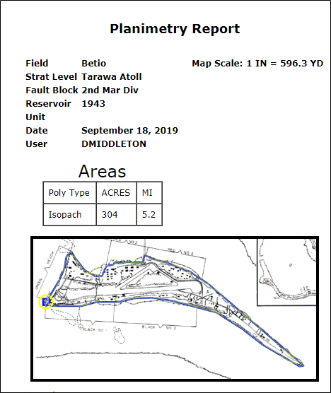
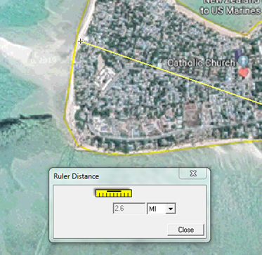
Since Kiribati is supposedly being inundated by Gorebal sea level rise, one might think that it must have shrunk in size over the past 76 years of climate crisis. So I planimetered a Google Earth image of Betio. Note that I cropped off the man-made jetty.
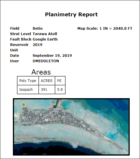

Betio appears to have a larger land area now than it did in 1943.
In 1943 “Betio was less than three miles long”.

In 1943, Betio was “no broader than 800 yards at its widest point”.

In 1943 Betio “contained no natural elevation higher than 10 feet above sea level”.
GEOLOGY
HYDROGEOLOGY OF TARAWA ATOLL, KIRIBATI by G. Jacobson & F.J. Taylor, 1981
Tarawa is a coral atoll formed on top of a volcanic seamount which rises steeply from 4000 m of water. The atoll is roughly triangular in plan and comprises a chain of small islands on the south and northeast sides which partially enclose a central lagoon (Fig. 2). The islands are generally 2-3 m above present sea level. The surface material of most of the islands is coral sand. In places, cemented coral hardpan forms a terrace 1.5-2 m above sea level. The first four bores drilled on Bonriki and Buariki intersected coral sand to depths of 7.5-11.5 m below the ground surface (Appendix 1). Beneath the sand, these bores intersected buried coral reef, 1.5-12.0 m thick. Beneath the buried coral reef, some of the bores encountered interbedded limestone and sand; others had a limestone sequence extending to 30 m below surface, the maximum depth of drilling. The total thickness of the limestone sequence is unknown. The nearest atoll to Tarawa that has previously been drilled is Funafuti in the Ellice Islands (Fig. 1), where volcanic basement was not encountered even at 330 m. The nearest atoll where basement has been intersected is Enewetok in the Marshall Islands, where basalt was encountered beneath 1300 m of limestone.
3 meters is about 10 feet.
I visited Dave Burton’s awesome Sea Level Info website to see what tide gauge stations might be available and found one from NOAA and several from PSMSL. These stations are scattered over a pretty wide swath of the Pacific Ocean (Kanton Island is about 1,100 miles ESE of Tarawa); but they all tell the same story.

Sixty years of relentlessly rising seas amounted to the width of the trigger guard on an M1 Garand rifle.
So, I extrapolated the sea level rise crisis out to 2100.

Over the next 80 years, sea level is likely to rise from just below the side skirt of an LVT-2 all the way up to just below the side skirt of an LVT-2.
While the sea level crisis would have posed no challenge to the LVT “amtraks,” the seawall was a different story.
Eighty-seven amphibian tractors, old and new, made the six-hour odyssey from the ill-chosen Transport Area and delivered about 1,500 Marines ashore, losing only eight vehicles to enemy fire—a remarkable performance under the conditions. Admiral Shibasaki was astonished by what he described in his 0930 report to his headquarters at Kwajalein as “amphibious tanks” (also described by one of his men as “the little boats on wheels”), the tracked landing vehicles that could travel from so far at sea, cross the exposed reef, and debark assault troops on the beach.9 David Shoup’s great gamble had paid off.
But now the “wheels” came off. Few of the LVTs could negotiate the seawall and force their way inland. Japanese machine-gunners recovered from their initial shock and shot many Marines as they struggled awkwardly to roll over the top of the 8-foot-tall vehicles and drop to the beach. A few drivers extracted their emptied vehicles from the shore and began shuttling the Marines of the fourth and fifth waves from the reef, as planned, but heavy fire from four 75-mm guns in the Pocket took a toll. Their lower hulls peppered with shell holes, many tractors filled with water and sank. Others simply ran out of gas after six hours of heavy acceleration. The shuttle plan failed. The Marines stranded on the reef took a deep breath and began wading the 500 to 600 yards to shore against relentless fire.
Naval History Magazine
Shocking! Betio needed a seawall in 1943!
Conclusion
The men of the 2nd Marine Division faced a genuine existential threat during those 76 hours of Hell in November 1943. Too many did not survive. However, their sacrifice undoubtedly saved many thousands of American lives in future amphibious landings.
It is truly ironic that the location of this historical genuine existential threat has become one of the poster children for today’s fake existential threat: The climate crisis.
Awesome!
Facts, backed up with proven history…. Yet any ody who says co2 is good is labelled as a fool. Personally I think we need to print leaflets about the truth of CO2, and post them across all nations… The smartest need to force themselves on to tv and radio shows…
You can’t bring facts into a climate argument – it’s against the rules.
It’s like Joe Biden said — “We believe in truths, not facts”.
Of course, “truths” can be anything you want……
You can take a horse to drink but you can’t make it water …
So, no. The faithful will not read your pamphlets.
…And you cannot oblige it to drink if it is not thirsty.
Duplicate commentIts amazing how some people are some people are so good at lying they can successfully lie to themselves for this long.
All the coral reefs are dead. Globally. That should say something..
And here is what sea level rise is going to bring by 2100 (spoiler: 2 meters of sea level rise is now the upper bound for planning in the New York area) –
“Ice sheet contributions to future sea-level rise from structured expert judgment”
https://www.pnas.org/content/116/23/11195
Its amazing how some people are some people are so good at lying they can successfully lie to themselves for this long.
All the coral reefs are dead. Globally. That should say something..
And here is what sea level rise is going to bring by 2100 (spoiler: 2 meters of sea level rise is now the upper bound for planning in the New York area) –
“Ice sheet contributions to future sea-level rise from structured expert judgment”
pnas .org/content/116/23/11195
You should lay off eating lead paint chips.
1 meter of SLR by 2100 is physically impossible and “all the coral reefs” are far from dead.

Now that Marine Ice Cliff Instability has fallen flat on its face and given the total irrelevance of Meltwater Pulse 1a, there’s nothing short of an asteroid impact on the Antarctic Ice Sheet or massive volcanic eruption from below the ice sheet that could trigger this sort of sea level rise.
Besides, if the risks of catastrophic sea level rise were upon us, I seriously doubt that your favorite president would have bought a $15 million beachfront mansion.
A great splash of perspective, as always, David. And, of course, thanks to your creative use of informative graphics, quite amusing too! Keep up the good work!
I had mixed feelings about being amusing while also writing about Tarawa.
There is a TV series called “The Lost Evidence” that was originally broadcast on the History Channel but has recently been re-broadcast on the Quest channel and one of the programs was about the battle of Tarawa. The program uses photo-reconnaissance pictures taken before and during the battle to help illustrate how the battle took place.
I can understand that.
But your humor showed absolutely no disrespect to those men. Your post showed just the opposite.
They won their battle at great cost, but valuable lessons were learned.
Perhaps the record of their battle can help win another.
“I had mixed feelings about being amusing while also writing about Tarawa.”
I completely sympathize. The American losses in the Pacific Theater of Operations were horrendous, both prior to and after Pearl Harbor. Japanese losses were also staggering, but I consider Japan as the aggressor, and can’t put their losses and ours on the same moral scale.
Thanks for this essay. I think it was both useful, and tasteful.
“I had mixed feelings about being amusing while also writing about Tarawa.”
Naturally! In KIA cumulative (both sides) per acre, no other major battle of WW II that I have researched compares. Even Iwo Jima doesn’t come close using that metric. The battle to take Betio was a concentration of fury on a scale pretty much stands without compare in WW II.
Lack of sufficient numbers of LVTs (Alligators) was a major contributing factor due to the exceptionally low tides that prevented conventional landing craft from passing over the reefs and thus causing the majority of the Marines to wade up to 400+ yards under fire just to get to the beach. Not only were they sitting ducks, when the radios operators got to shore their radios wouldn’t work due to not being sufficiently water proofed and thus, just as happened on Omaha beach later, the command had very little commo with the engaged units and surviving fire control teams on shore had no way to call for fire or air strikes during the critical first hours.
The failure to recognize the need for on site reconnaissance to reveal the state of tide and reefs was the key planning failure and that being recognized after Tarawa, UDT units were formed. Also Nimitz ordered that the Japanese defenses on Betio be studied and documented in detail and then replicated those defenses on another island where Navy ships tasked for close support of amphibious landings could practice their gunnery for subsequent operations. When it came to opposed amphibious operations, no matter where conducted, properly directed naval gunnery was the king of the beach for the assault waves. Far more effective than air support or the limited artillery assets the initial assault waves could bring with them. The Navy learned at Tarawa that no matter how small the assault area(s), blasting away, even with battleship main guns and aircraft directing the fire, simply did not get the job done.
This link https://www.youtube.com/watch?v=JolhiCbU_u8
is to the 20 minute shore documentary ‘With the Marines at Tarawa’. The film won an Oscar for the best short documentary. The thing is that the images of the carnage at Tarawa should never have reached the American people but several reels of film accidently made it through the censors and thus Americans saw for the first time since Pearl Harbor large numbers of US KIA in their News Reels at the theaters. FDR was furious, but Admiral King backed by General Marshal told FDR that the American people deserved to know just how costly it was going to be. Thus the short film linked to above was allowed to be produced.
Watched the YouTube video, now I’m highly motivated and truly dedicated. And is your first name Ooh?
Let me think about this. It’s an coral island built on limestone. So as the oceans raised more coral would grow.
Congratulations, old construction worker, you are an honor in both geology and biology. Darwin, in Voyage of the Beagle, described just this phenomena, the coral reefs building upward on the top of volcanic atolls. Great story, David, and the landing struggles are identical to what the vets from other landing described to me. Drowned atolls? Don’t wait for it.
‘Congratulations, old construction worker,…’
Many were of course US Navy Seabees at the time accompanying the various amphibious landings. My Australian father serving in Fiji at the time was landed at night with some of them from aboard the submarine USS Guardfish at Empress Augusta Bay on Bougainville to reconnoitre for the purpose of establishing a beachhead and airfield. That was after the first amphibious landing at Guadalcanal and the battle for the Solomons was beginning to turn into Operation Cartwheel.
Why would a young Australian surveyor and gunnery Sergeant serving in the Fiji Military Forces manning the Suva Battery find himself there? Because the very first US Marine invasion force for Guadalcanal had already come via Fiji to relieve NZ command at the time. They would lose a number of landing craft and US Marines with a training landing exercise in preparation for Guadalcanal as a tropical cyclone hit them but no matter for the survivors it would all be OK on the day had to be their attitude in war.
Lest we forget these largely 17-22 year olds (many lied about their age) whereas the Seabees were considered too old by their 30s but that notion would soon change with rifles accompanying their tools. Particularly so on the Bougainville beachhead as Japanese forces largely occupied the island until war’s end.
My father was the senior medical officer from 1955 to 1959 for what was then the British colony of the Gilbert and Ellice islands. He was based on Tarawa, the largest island of the Gilbert group. One of the regular injuries he saw in the hospital was of children who’d been scavenging the war debris for scrap metal left over from the Battle of Tarawa only about fifteen years earlier, and who’d been injured by exploding ordinance .
I have the book ‘Tarawa, a legend is born’ by Henry Shaw Jr, published in 1968. https://tinyurl.com/yyfb38vx It gives a very vivid account of the landings and ensuing battle, the first in a series of amphibious landings on the islands in the western Pacific held by the Japanese.
Casualties were heavy on both sides. The Japanese were very well dug in and fought almost to the last man. Only a handful surrendered. Total US casualties over the three days of fighting were 3,400 out of a total force of 18,000. Tarawa was indeed a bloody initiation to the war in the Pacific!
Tarawa was very costly in lives in one fierce battle because as noted-
“In the 76-hour Battle of Tarawa, U.S. Marines suffered almost as many killed-in-action casualties as U.S. troops suffered in the six-month campaign at Guadalcanal Island.”
https://www.history.com/topics/world-war-ii/battle-of-tarawa
Contrary to Tarawa the very first Marine landing at Guadalcanal caught the Japanese unawares as they were intent on completing an airfield that would have controlled shipping lanes as far as NZ and northern Australia and made any naval approach extremely hazardous. Relatively easy to take but as it transpired a ferocious war of attrition of ships and planes in naval and air battles would rage for 6 months before possession was settled and US advance begun.
For an appreciation of that critical time in the Pacific theatre you want to read ‘The Coastwatchers’ by Eric Feldt- https://www.amazon.com.au/Coastwatchers-Operation-Ferdinand-Fight-Pacific-ebook/dp/B00ING6FU2
That along with ‘Nothing Friendly in the Vicinity’ would piece together some war stories of my father and the seriousness of the times- https://www.amazon.com/Nothing-Friendly-Vicinity-Submarine-Bluejacket/dp/1591141303
Another terrible thing about Tarawa, is that the Japanese beheaded a group of New Zealand coastwathers and POW’s there.
Japanese troops also beheaded 19 captured Marine Raiders on Makin in the Gilberts.
They were murdered on Kwajalein. Admiral Abe was executed as a war criminal for that. Kwajalein is part of the Republic of the Marshall Islands.
David,
Yes, nine (accidentally left behind) of 12 Marines captured on Makin were taken to Kwajalein, where they were beheaded.
Abe’s underlings claimed to have opposed the atrocity. The Marines were supposed to be sent on to Japan for incarceration.
Not just the Imperial Navy, but also the Japanese Army beheaded US prisoners, soldiers, sailors, Marines and airmen.
Beheaded and far worse… I’m sure that some of the Japanese admirals and generals were scapegoats, but the atrocities, particularly in China, were truly heinous.
Two generals and a foreign minister were executed for their parts in the Rape of Nanking.
The problem is that even when you point out that robust historical records do not correspond to the “consensus” AGW view based on models and statistical gymnastics, you are ignored.
The UK mean sea level has been robustly determined by manual methods by the Ordnance Survey for many years, but it doesn’t fit the climate emergency so is ignored.
https://www.ntslf.org/products/sea-level-trends
There is even recent research on atolls and their ability to withstand storms
https://www.auckland.ac.nz/en/news/2019/07/16/pacific-atolls-can-adapt-to-rising-seas-and-extreme-storms—new.html
Low-lying Pacific islands in atoll archipelagos such as Tuvalu, Tokelau and Kiribati are likely to adapt to the effects of climate change rather than simply sink beneath the waves.
And similar to above land areas mapped from the shoreline of 101 atolls of Tuvalu
“Research by the University of Auckland mapped shoreline change of each of Tuvalu’s 101 islands across its nine atolls over a 40-year period.
Mapping of island size and position shows that Tuvalu has experienced a net increase in land area of 2.9 per cent or 73.5ha. Overall 74 per cent of islands in the group – a total of 73 – are larger now than forty years ago.
https://www.tvnz.co.nz/one-news/new-zealand/pacifics-tuvalu-expanding-likely-still-habitable-in-100-years-despite-rising-sea-levels
Coral reefs are of course living things … they grow up with a rise in sea level … they feed coral-eating parrot fish, who poop out coral “sand”, which then gathers at the base of the reef, and via wave and wind action gets deposited on the beach, and via wind action, gets distributed across the rest of the uplands of the atoll.
Gee, just like they’ve done for many hundreds of millions of years, ever since corals evolved from simpler sea creatures. Which is precisely why all the coral atolls of the planet exist, and have continued to exist, for millions of years, throughout out many dozens of massive sea level changes, both plus and minus, over the last 2.6 million years of the Pleistocene.
And the Climate Hysterics (I will henceforth stop referring to them as “Alarmists” since they have gone far beyond alarmism into hystericism) have a problem with that?
Here’s a graph of all of the tide gauge records around Kiribati, normalised to the Bom 1804 station. Even upto last month the rate of sea level rise is still only around 1mm per year.
1mm per year ????? tide goes out in the EUROPEAN waters, tide come in in the PACIFIC waters, storm hits the CARIBBEAN waters, oh yee there goes the moon, the earths gravity, . yep, flying from London to New Zealand (= – 24 hours ) and bot once parsing over land ????
WATER, WATER everywhere and not a drop to drink !
So about 56,000 people live on a 500 square kilometer sand spit in the middle of the Pacific Ocean?
That’s a population density of nearly 300 per square mile, which is not far below that of some of our most densely populates states in the continental USA.
That doesn’t sound very sustainable to begin with. Must be mainly a tourism economy?
I think their economy consists mostly of welfare checks… https://en.wikipedia.org/wiki/Kiribati#Economy
In the late 1940s a British study of Kiribati (then the Gilbert Islands) concluded that the islands would never be able to support a population of more than 25,000. The main problem was water supply, as although rainfall is high it is inconsistent, and not easy to store. Yet there are now 110,000 people living there.
Guessing, but perhaps they collect & store rooftop rain in cisterns like the people in Bermuda do.
Maybe the Climate Hysterics (I like that term!) will hysterical themselves right into some sort of brain f**rt that will leave them speechless. The real problem is this: you give them facts, which conflict with what they “think” they “know” and they stick their fingers in their ears and “la-la-la-la-la-!!!!” until you go away, because — well, it’s simple: THEY CAN’T HANDLE THE TRUTH!!!!!
Tarawa won’t disappear, but the CHers will all croak before the Pacific rises enough to add one inch of surf to incoming tides.
Hi David I hae a powerpoint that compares images of 2 coral atols and one volcanic island with fringing and barrier reef taken from Arthur holmes 1944 work Principles of Physical geology and current google imagery
damn little change over 60 years but in one case what was a bpair of oslands with a channel in between in 1944 is now one island with the former cjhannel standing at 14 metres above sea level.Holmes pictures must of course predate theimagery in hois books
I f you send me your email i will send he PPT to you
My email is alastairgray29@yahoo,com
Let’s not forget the nuclear tests in Kiribati. The world didn’t end and life goes on there. A prime example of just how great the exaggeration is about many environmental threats.
Bomb tests were on Bikini Atoll in the Marshal Islands, north of the Gilberts. Marshal and Gilbert were 18th century RN captains.
Marshalls. Two Ls.
My reading is that they are all part of the nation of Kiribati. Multiple nuclear tests took place on some of the islands, which are still inhabited tourist destinations today. What is your point?
Bikini Atoll is part of the Republic of the Marshall Islands, not Kiribati.
The US Pacific Proving Ground was based in the Marshalls, which are a separate country from Kiribati, which is how the locals pronounce Gilberts.
My point is that there were no bomb tests in the Gilberts.
Bikini lies about 875 statute miles NNW of Tarawa, on the side of the Marshalls farthest from the Gilberts and closest to the Marianas, whence launched the atomic bombers. The peoples of the Marshalls and Gilberts both speak related but not mutually intelligible Micronesian languages. So in terms of physical and maybe cultural distance, we’re talking Rome to Paris.
Alternatively, it’s like saying that the Nevada bomb test site (NNSS) is near Vancouver, BC rather than Vegas.
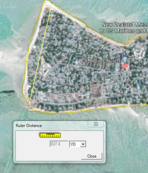
I loved the ruler you used to illustrate sea level rise, David. 🙂
I grew up on the stories of World War II and Korea and marveled at what the U.S. military accomplished through shear guts and determination.
I still marvel. I think the American success in war has something to do with the unique American experience of freedom, and the societal belief that we can overcome anything, which causes Americans to do extraordinary things in the most dire of circumstances. An advantage our enemies do not have, then or now.
Unlike our opponents and many of our allies, many US soldiers and Marines, were familiar with firearms before enlisting or being drafted. Many, if not most, were also more familiar with motor vehicles… including the ability to “hotwire” cars.
Add in the M1 rifle and the outcome of the war was inevitable right from the start.
Unfortunately the BAR was inadequate as a light machine gun, so our squad needed semi-auto rifles more than those of other countries. We also tried to compensate by assigning two BARs per Army squad and three per Marine squad, ie one per fire team.
The Army attempted as well turning the Browning medium machine gun into a general purpose MG, a la German MG-34/42, but it was too heavy as a squad weapon. Marines field-expedient adapted Stinger MGs from SBD dive bomber twin mounts into a GPMG, but its rate of fire was even higher than MG-42’s, aka “Hitler’s Zipper”.
Official Army table of organization and equipment remained at just one BAR per squad, but the infantry managed to acquire more, plus submachine guns, to augment its firepower.
The Army didn’t use fire teams in WWII. The concept of a standardized squad subunit was invented by USMC BG Evans “Gung Ho!” Carlson, based upon his observation of Chinese Communist guerrillas figting the Japanese in the 1930s. The original fire team for his 2nd Marine Raiders Battalion consisted of only three men, armed with a BAR, a Thompson submachine gun and the then new M-1 Garand rifle.
The whole corps adopted the fire team organization, but of four men with a BAR and three M-1s, although submachine guns, shotguns or scoped Springfield bolt-action rifles could be substituted. Thus a Marine squad had 13 men in three FTs, under a squad leader. Until this year, it still did. Two more Marines have now been added, an assistant SL and a systems (drone, etc) operator, for a squad larger than most, if not all, in the world today. The service briefly flirted with just 12, ie back to three-member FTs, plus the SL, ASL and SSO.
The Marines also have gone back to the future, turning in their belt-fed Sqaud Automatic Weapons for a lighter, magazine-fed M27 automatic rifle, versions of which now equip other squad members as well, to include grenadiers, but possibly not designated marksmen. Each squad is receiving a titanium Carl Gustav recoilless rifle, replacing the one-shot, 84mm AT4 anti-armor weapon.
Nine-strong Army light infantry squads have just two FTs, but enjoy a weapons squad at platoon level. Bradley Armored Infantry Fighting Vehicles can’t carry a whole squad, but they’re rarely at full strength, anyway. Mechanized and light infantry units have to be organized differently, given the armored vehicle’s driver and gunner.
The CG is replacing the SMAW, AT4 will still get issued when there is a need.
DDP,
Yes, it’s replacing Marine’s SMAW, but also AT4, which is in effect a one-shot CG projectile launcher. If every squad has a CG, then there’s less need for AT4. Instead, squad members can carry rounds for the CG.
The Army of course has no SMAW to be replaced.
What eco-loons don’t seem to get is that islands can & are built up faster than any sea-level rise — China building military islands in the China Sea for instance.
Off topic a bit, but I bet you know the answer David: why did the US forces landing in Normandy not use LVT buffalos? It has occurred to me they’d have reduced casualties on Omaha…
I don’t think it would have reduced casualties. Jumping over the sides of an amtrak is probably more dangerous than charging down the front ramp of an LCVP (Higgins Boat).
The LCVP could carry twice as many troops, they handled rough seas better, there were more of them, most of the LVT’s were in the Pacific, the Army had more experience will LCVP’s in the ETO/MTO and I think LVT’s had to be launched from LST’s, while Higgins Boats could lowered on davits from troop transports.
Armored amtracs carrying men across the beach to the base of the cliffs however could have saved lives. The swimming tanks that were supposed to provide cover and fire support sank.
Thanks… makes sense… in effect Omaha was an exception… in better weather (as John notes below) the tanks would have arrived with the infantry… and if the beach cratering had worked…
I guess it is reading that the German machine guns were able to open up on the landing infantry as the bow ramp went down and rake the entire landing craft which makes you think an LVT would have done a better job on that one beach…
(My late father in law landed on the British beaches on D Day, driving a jeep off a landing craft…)
The Germans had the high ground behind the beach. LVT’s didn’t provide much protection from above. Omaha Beach would have been a nightmare in any scenario.
A couple of planning changes would have saved many lives. The bombers should have dropped along the beaches rather than across them. Their bombs feel far inland, killing many Norman cows, but not cratering the beach nor knocking out German resistance nests.
We also could have used more smoke ammo. Lives were saved by the accidental screen of fires set by shells hitting beach grass.
The DD (swimming) Shermans were also a poor choice. Some did make it onto other beaches, but at least at Omaha, it would have been better to risk bringing LSTs close enough to shore for the tanks to wade in under track power. Submerged obstacles might have made that difficult in some places however, without their being blown.
And, as noted, IMO, armored amtracs could have helped the first waves.
Destroyer skippers and crew bravely moved in close to save soldiers’ lives with their direct five-inch gunfire on defending strongpoints, at great risk to themselves.
The LVT were developed for a specific task, to get across reef flats with occasional deeper channels. They were as a matter of fact used in Normandy, but as cargo carrier, not assault vehicles. The US Army considered them too weakly armed and armored to be useful in assaulting defended beaches.
They were also used in the Rhine crossings and Scheldt Estuary.
Yes, also by Canadian forces on the Scheldt…
The US Army was offered the use of some LVTs but refused them. The US Army also refused to use the various tank adaptations for special purposed that them Brits did. Later however there were some LVTs used in Europe for major river crossings. Monty used quite a few in his assault across the Rhine.
Ike left the decision up to Bradley, requested 25 flail tanks and 100 Churchill Crocodiles shortly after the demonstration in February 1944. The UK War Office agreed to supply them as well as British-crewed, Churchill AVRE assault engineer vehicles.
However there wasn’t enough time to produce the vehicles and train the crews, so on D-Day American forces were limited to DD tanks and their own Sherman dozer tanks and armored bulldozers. Thus, instead of supporting the US beaches, Hobart’s Funnies in 42 Assault Brigade served as a reserve for the British and Canadian beaches.
Hard to say how many Funnies might have made it ashore on Omaha, given the tragic loss of the DD Shermans off that bloody beach.
Forgot “who” after “Bradley”.
Rodriguez, A. B, et al., . 2014. Oyster reefs can outpace sea-level rise. Nature Climate Change. 4:493- 497.
Oysters make their own reefs, mechanism still needs study. They seem to know about peculiar tides and sea-level. There is a great deal of oyster restoration going on, seems like with not much understanding. Necessary for capturing nitrogen and carbon dioxide as if the shells last forever.
Sealevel rose about 120 meters at the end of each of the 8 last glaciations. No marine species that couldn’t outpace that could be alive today.
Thank you David,
My mother had two uncles that were there. I interviewed one of them. He was in one of the follow up waves and had to wade in the last bit. Japanese bullets fell in the surf like pelting rain. He spent the night pinned down by withering fire. There were only about 130 LVTs available. Higgins Boats were useless getting over the reef. By the end of the day there only 35 LVTs left.
The flag ship of the bombardment force was the battleship Maryland. When the Maryland fired its first salvo at 5:00 AM the concussion knocked out all the electronic communications and radars on the battleship. The generals and admirals could not communicate with their commands and they were slow to realize the situation unfolding. Finally an officer on the scene was able to get through that some kind of end run was needed, and lead a secondary landing, including a tank, on a secondary beach. They then began to drive through the Japanese positions from the side, relieving the Marines on, if recall correctly, Red Beach.
The bombardment by ships and aircraft was not effective because pin point accuracy was required to knock out the dug in positions of the Japanese. Such accuracy was not possible in 1943.
The Japanese defended Betio with 4,800 troops. Only 17 survived. The American loses were sobering. About 1,000 KIA, and 3,000 wounded. This might not seem excessive but the battle field was only one square mile, and the elapsed time only 77 hours. This was fitting to the Japanese strategy of 1943. Their strategy was then a Yankee go home type of strategy. They hoped to make advances by Allies so costly in blood that the Americans would seek a negotiated settlement.
While the casualties at Iwo Jima and Okinawa were far greater, in terms of time, space and numbers of troops involved, Tarawa might have been the costliest battle in Marine Corps history.
Peliliu was criminal because totally unnecessary.
And FDR ruled out gassing Iwo, even though there were no civilians on the hellish island.
Thousands of Marines died needlessly.
Happily my USMC aviator dad was not among them.
Gas would have made no difference to the results on Iwo. Gas only works on broad flat open areas during no wind conditions. None of those conditions existed on Iwo Jima, a mountainous windy island filled with caves and tunnels … virtually the entire Japanese garrison was housed in their cave and tunnel system, so they had to be rooted out, one or a few at a time, with soldiers using guns, flame throwers, explosives, etc.
Also, the US was a signatory of the Geneva Protocol prohibiting gas weapons, as was Japan, signed in 1925. The only reservation held by the US was that it would abide by the prohibition as long as its opponents abided by them. Japan did not use any chemical weapons against the USA during WW Two. If we had violated the treaty, then Japan would have been free to do the same to us. Which is why most of the world’s nations signed the Geneva protocol.
Japan had already used chemical weapons against our Chinese allies in 1943, so the US was in the clear to retaliate.
There was some concern about counter-retaliation when we invaded Japan, but, as it turned out, after May 1945 we learned about German nerve agents, so Japan’s WWI-era chemical weapons would have been rendered obsolete.
That would still have left us vulnerable in April on Okinawa, but it was heavily populated with civilians.
US chemical weapons in 1944 would have worked well on Iwo. To take but one example, sulfur mustard vapor is heavier than air, so will settle in low-lying areas. The services’ CW experts had a good plan. American army and navy COs approved it, but the White House nixed it.
Almost 7000 young Marines were KIA as a result. Around 90% of ~21,000 Japanese defenders died anyway.
“Gas would have made no difference to the results on Iwo. Gas only works on broad flat open areas during no wind conditions.”
I’ll disagree with that statement.
Gas is heavier than air and sinks. The Japanese defenders on Iwo were mostly underground. Tunnel rats in Vietnam found CS to be effective.
I can’t spell today.
Peleliu.
I might be thinking of the wrong amphibious assault but, one of the lessons learned at Tarawa was that the naval bombardment was firing on too flat a trajectory. Plunging fire was needed for better penetration and was more likely to land in an entrenchment rather than outside it.
“Around 80 percent of Earth’s coral reefs died off, tanking fishing …”
While coral reefs are beautiful and have very high diversity they are practically useless for fishing. The good fishing grounds are almost all nutrient-rich, CO2-rich (i. e. “acidified”) upwelling areas.
About the only practical way to “fish” a coral reef is with explosives, which incidentally is a much bigger threat to reefs than climate.
Speaking of explosives, Bikini Atoll is still considered too radioactive for human habitation, but the crater excavated by the 15 MT detonation now teems with marine life, to include apparently healthy fish.
According to the present scaremonger cultural, it always seems people are far more vulnerable to radiation than any other lifeform.
Seen a documentary somewhere that other than eating some particular plant (coconuts?) that had an affinity for absorbing strontium-90, crops planted on certain previously-nuked islands were not dangerous and neither was the sea-life harvesting from the shores/nearby water
True. We err on the side of safety.
It is possible however that the healthy fish just live short lives, so don’t have time to develop cancer. Ot they move in and out of the crater, limiting their exposure.
A shark species with two dorsal fins might have undergone a mutation there, losing one of its fins:
https://pangea.stanford.edu/news/radiation-exposed-corals-bikini-atoll-may-hold-insights-cancer
IMO, it’s wise to wait a while longer before people return to live full time there and eat animals and plants from the atoll and adjacent waters.
I think of this sign whenever I hear anybody panicking about staying ahead of the sea-level rise:
https://www.bing.com/videos/search?q=happy+feet+we+better+move+in+half+an+hour&&view=detail&mid=9A1A36FDCEA648E30EE89A1A36FDCEA648E30EE8&&FORM=VRDGAR
The NOAA has a chart on relative sea level rise:
https://tidesandcurrents.noaa.gov/sltrends/
It looks to me that most places will require a few hundred years to rise 6 feet. Is this how you guys that know more about these things read it too?
I posted it to a page on The Times running an article on the kids climate “strike” but it had been moderated off – presumably because it doesn’t induce panic.
Another island that keeps coming up in discussions about SLR is Tangier Island in the Chesapeake Bay. This island has been loosing land constantly, as shown in the 1st surveys in the mid 1800s.
https://images.nature.com/original/nature-assets/srep/2015/151210/srep17890/extref/srep17890-s1.pdf
I have met Climate Activists from the University of Texas taking the ferry from Reedville Va. to the island just for photos for a class project on global warming threats to humanity, paid for by the state.
The Atlantic seaboard of the US is sinking because Canada is rebounding from losing the weight of its ice sheets. Same as southern Britain thanks to Scotland’s rebounding.
We played a softball game against Tangier on their island nearly 6 decades ago. We lost, but on Google Earth looks like they still have an airstrip. Chesapeake Bay Islands have had flooding problems for a long time, don’t see the ball field. Not much change by Mississippi River delta and environs standards.
Charlie, I mentioned Tangier Island sometime back and how its being used as a SLR scapegoat. IT HAS been disappearing since the 1800s!
So, somewhere between one and two standard-height cans of SPAM?
Oh yeah! That would be an awesome scale reference!
David,
I appreciate your choice of semi-automatic ruler.
Normandy “assault weapon”, with eight-round magazine, but truly high-powered cartridge.
And, it actually used “clips” to charge the magazine.
Ammo can still come in clips as well as bulk, but today’s magazines are detachable rather than en bloc. Safer on the thumb! And minus the telltale ping on empty.
I think there was a History Channel show about the air war against Germany in Europe and one line stuck in my memory : the air war in Europe cost more lives than the entire war against Japan. That’s sobering.
That’s believable. The losses were horrendous before P-47 and P-51 fighter planes were available in large numbers.
IIRC, the US Navy suffered more casualties due to Kamikaze attacks at Okinawa, than the rest of WWII combined.
And the Brits were at it much longer than the USAF.
55,000 dead in UK’s Bomber Command.
BTW, if any US visitors to the UK are in the vicinity of Cambridge, consider visiting the Cambridge American Cemetery… a very moving memorial to the US fliers (and others) who flew from England during the war and made the ultimate sacrifice..
https://www.abmc.gov/cemeteries-memorials/europe/cambridge-american-cemetery
A survivor of The Bataan Death March was a friend of my Dad. (In the 7th grade I also got my first pair of glasses from him.)
He wrote a book about his units (Armored) experiences in the Philippines.
I don’t have it but I do remember him writing that the atrocities that happened depended a lot on who was in command of the troops guarding particular sections. Some of the weak in his section were actually allowed to ride part of the way.
I was a kid. I regret not asking questions of such people in my past. My Mom’s uncle was one of Patton’s translators. One of my Uncles was in the China/Burma theater and stayed for bit after the war. (Ho-Chi-Min was once one of his neighbors.) My other Uncle was in the 82nd Airborne. (Not at D-Day but he was at The Battle of the Bulge.)
I worked with a man that was an Italian WW2 vet, in one of their elite units. I was older and he talked more. Mussolini sent some units to Stalingrad. His was one of them.
When Italy was invaded by the Allies and surrendered he was in Yugoslavia. They were ordered not to turn their arms over to the Germans but only to the Allies. The Germans got there first. He told me but I don’t remember the numbers before and after the battle.
He was put in a German POW camp in Italy. After he escaped and was recaptured 2 or 3 times, he was sent to Dachau. That’s where he was at the end of the war.
I remember him saying that on work details outside the camp 4 guards would be assigned to 10 or 20 Italians while 4 guards would be assigned to 100 Jews.
He asked an older Jewish man why they didn’t fight more. (Remember that at that time there was no nation of Israel.) The man told him that they considered their treatment to be God’s punishment.
(It wasn’t God, but I won’t get into that.)
This was meant to be a part of the https://wattsupwiththat.com/2019/09/20/tarawa-and-the-war-against-sea-level-rise/#comment-2800183 subthread.
(My internet went down then came back up. Somewhere in there when I hit “Post Comment” it ended up a comment to the original post.)
Between 1999 and 2002 I lived for three full years in Tarawa. Before I went there I was told very seriously that “Kiribati is at the cutting edge of global climate change”, and that “two Kiribati islands had already vanished under rising sea levels”. The first statement may be a matter of opinion, but the second was complete nonsense. In fact my experience in Tarawa turned me into something of a climate change sceptic, simply because the gap between the claims and rhetoric of climate change espoused by foreign “experts” and the reality of life on a coral atoll in the Central Pacific was so great.
I lived on Bairiki, an islet which was the seat of the Kiribati Government, and which is connected to the atoll’s most populous islet, Betio (site of the Battle of Tarawa) by a then recently built causeway, which had completely changed tidal patterns in the lagoon, resulting in an altered configuration for a larger islet, Bikeman, and the submergence of a nearby smaller islet. Nothing whatever to do with any sea level rise – as confirmed by SOPAC, the South Pacific Geoscience Council (a “hard science” organisation with no axes to grind).
The local inhabitants of Tarawa were mostly rather amused by the insistence of visiting foreigners – especially those employed by international organisations -that Kiribati was was under imminent threat from climate change. However, because Kiribati is indeed a very poor country, they were happy to receive the monetary and other aid thrust at them by both international organisations and individual countries as a consequence of this belief.
Incidentally, Kiribati, as the former Gilbert Islands, had indeed been the site of nuclear testing in the late 1950s and early 1960s. Initially the tests were carried out by Britain in 1957/58 as part of Operation Grapple – these were air burst tests of thermonuclear weapons by RAF Valiant bombers based on Christmas Island (now Kiritimati). Later, in 1962, the United States used the same facilities on Christmas and also on Malden Island to conduct a more extensive series of tests as Operation Dominic.
I stand corrected. My apologies to Mr. Hart.
But the Dominic shots were at high airburst elevations, without detectable fallout on the Gilberts.
https://en.wikipedia.org/wiki/Operation_Dominic