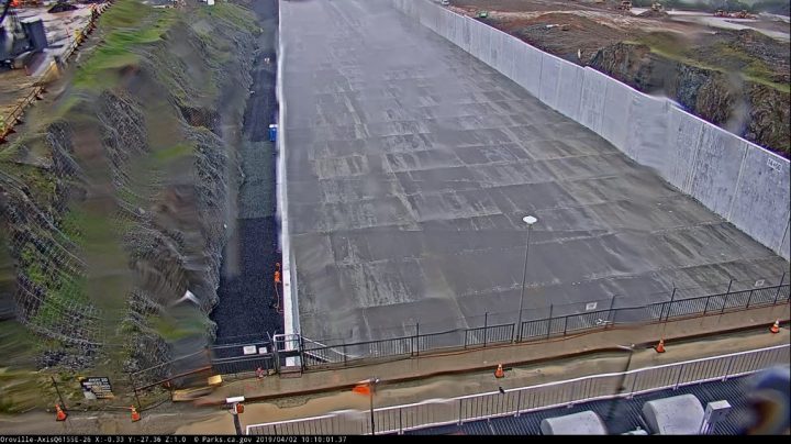
The Lake Oroville dam spillway is supposed to open at 11AM local time (Pacific Time) today. according to reports from the California Department of Water Resources. We have two live cams available for you to watch as the event unfolds.
Readers will surely recall that in January 2017, the spillway collapsed due to a lack of maintenance by DWR, during a strong atmospheric river event that soaked northern California.
Click the images or links to get the live cameras.
http://www.parks.ca.gov/live/lakeorovillesra_spillwaytop
http://www.parks.ca.gov/live/lakeorovillesra_spillway
h/t to Eric Nielsen
UPDATE: 11:20AM PT – It appears the WUWT announcement has overwhelmed the cameras, probably because DWR didn’t plan for the interest and buffer the demand properly with a streaming service.
I was able to make one screencap before the camera stream stopped.

Also there’s this interactive graph, that shows the lake levels.
The webcam has been off every time I look!
Looks like it is back now
11AM local time (PST) today
PST?
we are on PDT…
Thank you Leif… If I had read this (to open 11am…), I would have refrained from my post!
Yep, PST is a mistake as it is now PDT… 🙂
fixed, thanks
Very cool. Thanks
Any issue with dam not containing the lake?
Did we slashdot their camera?
The operators appear to have maxed out the outflow through the power plant.
With rain and snow now and continuing through Wednesday…
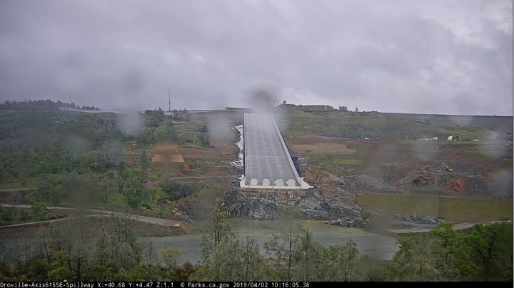
Water level is at 854 feet as of 8am 2 April which is 47 feet below the emergency spillway, and rising about 1 ft/day even with max power flow release.
So Good decision to stay ahead of the coming rapid snow melt.
It is less a decision made than following the operating plan. In large operated dams (my experience following US Army COE dams, I assume CA DNR dams would be the same) the operating plan is adopted and has the force of law equivalent to any regulation. This protects the operating agency from suit, as for example the floods along the Missouri in 2011: the Corps followed the operating plan but could not restrain the flood.
In most dams that include flood control as a justification there is an operating elevation at which the operators match the inflow and outflow with a limit on the outflow to prevent flooding. The volume of the reservoir above that is reserved for flood control: if the release cannot be made without flooding, the excess water gets stored in the flood control volume. (There are other considerations in the discharge from Oroville, different limits for differing conditions but this is complicated enough already)
In the case of Oroville, that level now varies according to the moisture condition upstream and the time of year: the water elevation under current conditions per the operating plan appears to now be 854. Depending on moisture conditions the elevation at Oroville can vary from 838 to 870. Under the old operating plan it was a fixed elevation of 848. The modification was made to finally account for dams that were planned but not built.
The operating plan was developed by modelling according to the design flood from the original design and interpolations from that. I would like to have seen more modelling and some reconsideration of the design flood but perhaps that is what they could do with the time they had.
Looks quite rainy…. for a permadrought!
How DARE you question Jerry’s AUTHORITUY!! 97% of all federally and state funded climatologists agree … CA is STILL in THE WORST DROUGHT IN THE HISTORY OF THE STATE. Quick … call up some drought pictures of an intentionally-drained Folsom Lake. That’ll explain it for all the community college graduate “journalists”. They are really good at copying and pasting propaganda. We should all cherish Dear Leader Jerry. He carrrrreeeeeeed about CA. Cared-enough to admit and care for 10million new illegal resource-users.
They should clean the lens off. It has water droplets on it – I assume from the ’80s, when the drought was not yet in full effect.
Many onlookers in yellow rain gear waiting for the opening.
Just opened.
Only blacked out video…
That’s ok, the Californica Grizzly on the state flag, etc. has been extinct for roughly 150 years.
It was on for a few seconds around the opening-up. Pretty spectacular….then offline again.
Yah, it has been ~slashdotted~. No flow on the Streaming.
“This live event is over”. Huh? Mine never started!
What kind of fake-out nonsense is this? I just got back from a five hour Nature Walk (interrupted by occasionally whacking a golf ball) and clicked on the live cams. Nothing. I was hoping for catastrophe but nothing. All of that record Sierra Nevada snowpack getting ready to assault looney Californians and nothing. I need a drink (not related to my golf results).
It was a gorgeous, warm, weekend here in N.CA … top-down weather all weekend. I even got a little sweaty. Here comes the AGUA!! The snowmelt is gonna be EPIC this year. Class 5 rafting on every river all summer. NOTE: Beginners stay OUT of the rivers and streams. There’s gonna be a lot of drownings this year. Be SAFE!
It snowed here is SC yesterday (4/1) and today (4/2).
We’ve had a relatively warm winter, but a cool, late spring.
I hate to ask… South Carolina? Southern California? Southern China? OK, I’m pretty sure it wasn’t the latter, but I am confused about the first two.
We didn’t get any precip, but here in NJ this morning it was 24°F.
Pretty sure it’s South Carolina. It also snowed across the border in NC.
The cameras seem to be permanently offline. Good enough for governement work I suppose….
I saw top and bottom camera streaming live for a few seconds at 11:03…looks like it worked for a few seconds.
Then just buffered and went to black.
Notice: The Lake Oroville SRA webcam’s may be offline at times due to issues related to the repair of the webcam’s network connection.
Someone tripped over the wireless
blancolirio is livestreaming the event right now
His coverage has been by far the best. 🙂
I agree.
Liked some of his comments about the main stream media only wanting disasters and the bad side of things and when the spillway didn’t fall apart they pushed off to find the next thing they can report as a bad.
It must wind them up big time having people who understand or are willing to listen and learn about things and making that available to the public.
James Bull
It’s 11:24 and I’ve been watching this for several minutes. It’s a GO.
Hmmm looking up from the bottom, I think there is water leaking behind the vertical containment wall. Maybe they are testing whether they can wash the whole darned thing out again !
Plastic spread on the ground prior to backfill.
Live link: https://www.youtube.com/watch?v=jCQmIklHMkY
I’m sure the locals downstream won’t mind about the video outage! /sarc
Call it the Jerry Brown Spillway of Permanent Drought Policy Crusades.
Kenji
Yes–there is no point paddling any river at flood, in any kind of a canoe, kayak or raft.
When the eddies are in the trees.
Mainly paddled a number of WW canoes and then when the knees couldn’t take it anymore went to a kayak.
One time in paddling downstream from a hydro-dam the rapids, although 2.5 to 3, did not seem right.
Asked one the local guys and the explanation was that the water was different after they had taken the electricity out of it.
“The Oroville Dam main spillway is being used for the first time since repairs were made” KCRA News 39 min video
It is interesting that the flow splits in to waves or surges. It appears to happen in the area where the spillway steepens, though we do not see the area above that. In this portion of the spillway the velocity of the water accelerates from the 50 ft per second rage to the 150 ft per second range, if I remember my calculations from months ago correctly.
It would be very interesting that the flow splits, because that would violate the continuity equation. The change in velocity is accompanied by a change in cross-sectional area (and/or density, but water is usually treated as incompressible) such that mass is conserved.
Yet it does, per the video.
please explain, if you can,
Not attempting to explain at all, but I know that automobile traffic on an open road mimics the behavior of the water that you see in the video. I will bet that traffic engineers and hydraulic engineers consult each other about this.
They are called hydraulic jumps, and very commonly occur where water flows down a steep surface.
I suspect the reason why the water forms those rollers is similar to the reason why buses tend come in threes. (You wait for half an hour and then three turn-up at once)
Just checked, both seem working.q
Wow, pretty impressive video!! Makes me wonder…
How much water going to the ocean rather than being saved for the (next) drought?
How much electricity not being generated because water is going down spillway rather than through turbines?
How much of that most powerful GHG dihydrogen monoxide is being generated with the mist at base of spillway?
Too bad California has neglected or refused the infrastructure needed to take advantage of this season’s heavy rains to prepare for the next drought. On the long list of reasons to leave.
Existing dams run by the state hold over 15 million acre feet. California’s 40 million people use less than ten million, and a significant chunk of that is provided by local and regional water agencies operating their own dams.
The droughts are agricultural, but farmers would rather deplete groundwater supplies than pay for the infrastructure that would benefit them. They prefer people pay for it, and the state forces cities to ration water to convince people they should pay.
If it’s all been fixed why the dirty water bottom left
Kicking up the junk that’s settled in there over the last year.