UPDATE 8PM PDT
Lane is now a Tropical Storm, with maximum sustained winds of 70 mph.
As of 5 PM HST, Tropical Storm Lane was located 150 miles south of Honolulu, Hawaii, and 160 miles west of Kailua-Kona, Hawaii, and is moving to the northwest at 3 mph.
UPDATE: 4PM PDT
https://twitter.com/RyanMaue/status/1033123058016509953
UPDATE: 11:50AM PDT
Hurricane lane is now a category 2 storm and has made the north turn, NWS Honolulu says:
Hurricane Lane is a category 2 storm this morning, with maximum sustained winds of 110 mph. As of 5 AM HST, Hurricane Lane was located 180 miles south of Honolulu and around 145 miles west-southwest of Kailua-Kona. Lane is moving slowly toward the north at 6 mph.
A slow northward motion is expected to continue today. A turn toward the west is anticipated on Saturday, with an increase in forward speed. On the latest forecast track, the center of Lane will move dangerously close to portions of the central Hawaiian islands later today and tonight.
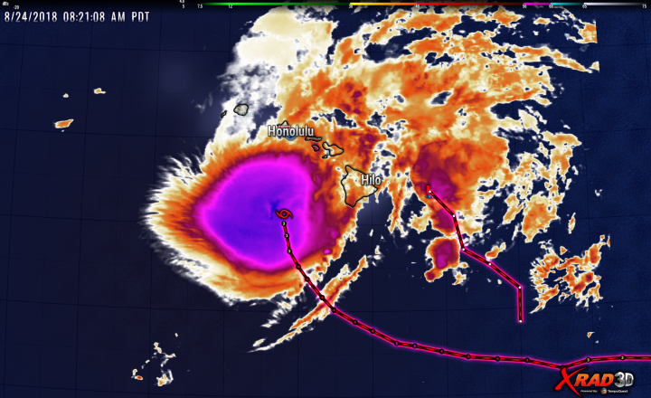
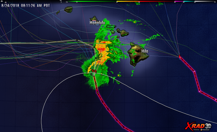
Here’s the most recent tracks and radar showing Lane at Cat2 level. Note that the position marker at the next update period suggests Lane will drop to a CAT1 storm before turning west. It appears there will be no direct hit on the Hawaiian Islands (Oahu was a big concern), but there will lots of rain from rain bands.
If it wasn’t enough that torrential rains hit the Big Island over the past 24 hours, causing widespread flash flooding, a second tropical system, a tropical disturbance called INVEST 95C is now threatening even more rain. An invest in meteorology (short for investigative area, alternatively written INVEST) is a designated area of disturbed weather that is being monitored for tropical cyclone development.
In the photo below, the second smaller track to the right is the path of Invest 95C:

Here is 95C along with computer model forecast tracks. Some of the forecast

Invest 95C is currently a tropical disturbance (Marked with an L for a Low pressure area) and has maximum winds about 30 mph with a central pressure of 1009MB. It is currently headed to the NW at 11 mph, which would have it tracking along the east side of the Big Island. Some of the computer model forecast tracks in the image above show it crossing or very near the Big Island.
The threat of additional rain on the Big Island comes mainly from rainfall induced by orographic lifting should Invest 95C make a crossing or near-miss. This will induce significant rainfall, which will quickly run off the already saturated ground from the rainfall from Hurricane Lane, causing flash flooding.

Let’s hope those folks are spared additional rainfall and flooding. However, regardless of the outcome, we already know what the MSM and the other usual suspects will claim is the cause of the unsettled weather in the mid-Pacific.
Maybe they will realize a benefit of having the activity of Kilauea cooled down from the rains.
Volcanoes and rain can have some nasty effects.
There is a whole gamut of things that can happen, some of which could be beneficial and some of which could be quite bad.
Presumably driven by all the CO2 molecules rushing to be counted at Mauna Loa.
I hope the residents have enough warning & keep safe.
I was in a cyclone while in Vietnam and was camped out by a small creek when the rain started and it rained 22 inches in 24 hours and we sat there and watched that creek visibly get higher and higher and higher, like watching a bathtub fill up, and it turned into a roaring river. The creek finally got out of its banks and we had to move to higher ground. That was a miserable couple of days.
Wattsup with the Atlantic. No news I guess is news with the usually busiest month of August winding down.
A tropical wave has just appeared off the west African coast (~13° N).
You’ll need 2 weeks of popcorn to watch this one.
The NHC gives the wave 0% chance of development in the next 5 days.
While April is the cruelest month, September is the most active month for Atlantic hurricane activity. But it has been ‘good news’ so far, with very little going on in the deep tropics. Most of the Atlantic storms have formed in the subtropical region and most of the African Easterly waves have been suppressed. Let’s keep hoping.
Definitely keep hoping, but Joe Bastardi seems to think that conditions for tropical development are beginning to improve for Sept.
Its interesting that the INVEST should form so close to Lane. That looks close enough that the outflow from Lane might disrupt its formation..
Anyone know how often this is observed (secondary low pressure center so close to a hurricane/cyclone/typhoon)? This thing looked more organized about 24-36 hrs ago. Fingers crossed for the folks in the Islands.
The volcanic vents are not going to like this.
She’s “not going to like this.”
Or maybe she will.
No Kahiki mai ka wahine
o Pele,aina mai o Polapola,Mai ka
Mai ka punohu a Kane,
Mai ke ao lapa i ka lani.
Translation:
The woman Pele comes from Kahiki,
From the land of Polapola,
From the rising mist of Kane,
From the clouds that move in the sky.
The annual precipitation at Kilauea is ~70 inches. August = 4.6 inches.
Elevation is just under 4,000 feet.
The Hawaii 24 hour record (has been 38 inches at Kilauea, (Kauai) on Jan. 24-25, 1956.
This appears to have been broken in April at Hanalei.
The Northeast facing slopes are well acquainted with rain.
The places that generally get very little rain are the places that suffer the most when the storms come from a different direction.
For some reason, this sort of repeated storms reminds me of the Gulf of Mexico last year. I just hope Hawaii does not have the same sort of damage.
The reason is news media are stupid- one could say the Gulf Mexico is on the news media’s mind. But Hawaii is small and surrounded by ocean, and it on average gets about inch per day rainfall. It will get more rain in shorter time period, but not a huge chunk of land getting a lot more rainfall on it- like it did in terms the Gulf of Mexico- Texas, etc.
High winds might be a story in regards to Hawaii, but rain, even a lot of rain- not so much.
Hurricane Lane is approaching Honolulu.

Looks more like an average tropical storm
https://www.ventusky.com/?p=16.5;-154.6;5&l=wind-10m
Two things: 1) Am I the only one who hears ‘Hurricane Lane’ and thinks of ‘Tornado Alley’? 😉 and 2) over the last 36-48 hrs this semi-organized disturbance has been quite noticeable on the satellite loops, directly east of Lane. I’m frankly surprised it’s only now getting attention. Going to be a wet few days there…
Sorry if the above sounded snarky; it was certainly not meant that way. I suspect a lot of folks have noticed that disturbance–I just haven’t seen it mentioned anywhere prior to WUWT today.
When I first saw the words “Hurricane Lane” on the news, my first thought was “what the hell is a hurricane lane? They go wherever they want to.” Eventually I figured out it was the name of an actual hurricane.
im sure some news outlet will try and link the CO2 from the volcano directly to this hurricane hitting that same volcano. something with a head line like “mother nature strikes back at her own climate change” or something like that.
Threat to the big island? I think I hear it speaking: “Heh. Come to me. And DIE!!!!!”
Hmm. I just took a look at 95C, but the Central Pacific Hurricane Center doesn’t mention it; neither does Joint Typhoon Warning Center.
Like I was saying
something already known back in 1983
if there is some global cooling [as determined by myself/ just click on my name to read my final report]
there is more rain and precipitation around the equator and droughts and less rain above the [45] degrees.
Simple physics. Really.
What a pity that so much important information – like that of the flooding of the Nile – has all gone lost-
slaughtered on the altar of ‘man made’ global warming….
Aloha Invest 95C
http://www.ssd.noaa.gov/goes/west/tpac/ft-animated.gif
Strong upper western wind.

Jetstream:
Was that painted by Vincent Van-Gogh?
ear ear
Looks like a Shih Tzu.
Part of a larger work: “Stormy, Stormy Day”
“Stormy, Stormy Day”
That’s a great title for the picture.
In a few hours they will be heavy rainfall in Honolulu.

Here’s a poser for you.
The months long volcanic event in Hawaii was partially driven by groundwater and liquifactive failure of debris structures within the Caldera of Kilauea. It “seems” to be paused for now but the amount of groundwater it evaporated was immense. Since it’s a shield volcano it is a broader non-solid structure made of a series of layers that could be described like building up the inside of a cone with individual layered leaves of shattered glass. The structure is not greatly unlike a rose’s petals. There is normally an amount of water between layers and contained in the ejecta fill and outside the shield wall in that ejecta as well. Much of this was fairly heavily depleted and a great deal of the ground moisture out along the LERZ is depleted as well.
And in comes a Foot Per Day storm dumping into everything.
A very nice ponderable. How much “greenhouse gas” emission over time is actually caused by the exposure and depletion of subsoil water?
Hilo absolutely does not need any more rain. The flooding there is already bad.
Unfortunately.

http://tropic.ssec.wisc.edu/real-time/mtpw2/product.php?color_type=tpw_nrl_colors&prod=epac×pan=24hrs&anim=html5
I am on the Leeward side of the Big Island on the Hamakua Coast at Laupahoehoe 25 miles north of Hilo. We have had about 20 inches of rain in the past 24 hours and it is still hammering us. Our community sits on the hillside above Laupahoehoe Point on HWY 19. Power has been on and off. Rain is hammering us so hard it is difficult to hear inside the house and at times the rain is sideways. The ground is 100% full of water.
I’m sorry, but the hurricane will circulate over the islands. You must be at the ready. Regards.
Yikes! Don’t take this the wrong way, but better you than me.
My sympathies. We were in Hilo Sunday and Monday before returning to Puako. We walked across both bridges over the Wailuku River and I took pictures of the hydro station and turbine outlet from the Wainaku St. bridge. Looks nothing like that now.
Wailuku River and hydro turbine
This image shows some kind of tower just off the Bayfront Highway that when we drove by had high water marks painted and marked with years from previous floods. I didn’t take a picture of it and the markings don’t show in street view:
Bayfront tower
Clearly visible eye of a hurricane.

That one-two punch ought to end Hawaii’s drought (ongoing until Hurricane Lane came along) for the rest of the year…
http://droughtmonitor.unl.edu/CurrentMap/StateDroughtMonitor.aspx?HI
I don’t understand those statistics at all. The areas it shows in drought conditions are all on the normally dry side of the islands. All the moisture the trade winds bring to Hawaii is wrung out going over the mountains. Puako, on the western side of big island is the the middle of what that chart lists as D2 – “Severe Drought”. But the average annual rainfall there is only 11 inches or so with the wettest month being December with almost 2 inches. It’s coastal desert; how much more drought-like can you get?
So far this year Puako Bay has received 15.4″, so it’s on track for a yearly total roughly 50% above average. Again: not a drought.
The wettest part of the island is a little up slope from Hilo on the eastern side and receives about 300 inches in a normal year. They are never in drought conditions and especially not now.
Does anyone know how Hawaii Electric’s 100% Renewables worked in the 100+ MPH winds and cloud cover? Their commercials suggest that “Fields of Dreams” solar panels and windmills are their only power source. Are those assets still functional?
They are just fine. But the infrastructure isn’t doing so well. The supposed 100 mph winds had those turbines pumping out so much electricity they melted all the transmission lines. The tips of the rotors exceeded Mach 2 for a new record. The Guardian is sending someone (as soon as the airport reopens) to document how well it all stood up. /s
I’m wondering about the detection of CO2 over Mauna Loa. We are witnessing a mammoth washout of atmospheric CO2 by the rain.
More will blow back in overnight from LA
Hurricane Lane already as a tropical storm gives a strong rainfall over Hawaii.

Current location Lane. Jetstream continues to block a tropical storm over Hawaii.


That same jetstream is also bringing moisture into the U.S. Love this rain in the month of August!
In the Eastern Pacific a new hurricane is forming, which will come closer to Hawaii in a few days.
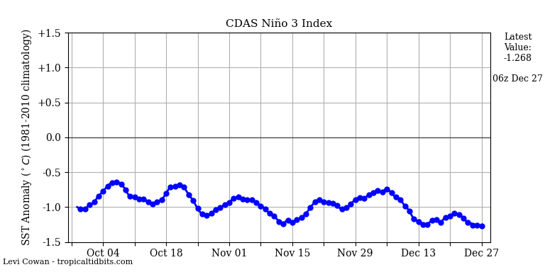
The Nino 3 index is negative.
