The featured image is a USGS picture of a boulder from a debris flow in Venezuela. I chose not to use the photos from the Earther article to avoid any copyright issues.
Apparently Storms Can Push 600-Ton Boulders Around
Maddie Stone
On the rocky shores of a windswept island just west of Ireland, the 620-ton boulder looks almost at home. But careful analysis of its position over the last few years has revealed something odd: between the summers of 2013 and 2014, the boulder shifted a couple meters toward the sea. That discovery is causing scientists to rethink what they know about the impacts of powerful storms.
In fact, the rock is one of more than a thousand boulders—including a handful of Very Large Boulders (VLBs and yes, that’s a technical term) weighing over 50 metric tons—shuffled around by the powerful storms that pounded Ireland’s west coast during the winter of 2013-2014, the stormiest in decades. Described in a new paper in the journal Earth Science Reviews, these boulders offer some of the first concrete evidence that storm waves, not just tsunami waves, can pack enough punch to hurl giant chunks of Earth around. (For comparison, 100 metric tons is about half the weight of a Boeing 747.)
In a warming world where more energy in the oceans and atmosphere could mean more powerful storms, that’s an important insight.
“Ten years ago, it was possible to say storms can’t move 50 ton boulders,” lead study author Rónadh Cox, a professor of geosciences at Williams College, told Earther. “If you were building a model of storm intensity or thinking about risks posed by severe storms, then your upper level for storm energy were to some extent informed by that understanding.”
[…]
Earther
“Ten years ago, it was possible to say storms can’t move 50 ton boulders”… This is where I rolled my eyes.
https://imgur.com/gallery/uzBxh
But, 20 years ago, it was possible to say that storms did move VLB’s around (Ms. Stone is correct about VLB’s being a genuine technical term)…
QUATERNARY RESEARCH 48, 326–338 (1997)
ARTICLE NO. QR971926
Boulder Deposits from Large Waves during the Last Interglaciation on North Eleuthera Island, Bahamas
The greatest weight (from an estimated denasity of 2.4 g/cm3) is about 2,300 tons for Boulder 1.
OK… The largest Eemian Bahama Boulder was 2,300 tons. It was ten times the size of Holocene boulders moved by waves. That would be 230 tons. Yet, 10 years ago, storms couldn’t move 50 ton boulders.
For that matter, the Irish boulders which couldn’t be moved by storms 10 years ago, were very likely deposited by storms…
PUBLIC RELEASE: 27-NOV-2017
Boulder deposition by tsunamis and storms
PROCEEDINGS OF THE NATIONAL ACADEMY OF SCIENCES
A study explores the origin of boulders deposited on cliffs in western Ireland and New Zealand’s North Island. The question of whether tsunamis or storm waves are responsible for the presence of boulders on ocean cliffs remains unsettled. John Dewey and Paul Ryan compared two deposits of boulders weighing more than 30 tonnes on the coastline of Annagh Head, western Ireland and on the Matheson Formation, a Miocene deposit in New Zealand. Oceanographic data, field measurements, and historic storm accounts indicated that Annagh Head deposits, which weigh more than 50 tonnes, are subject to 20-30-meter-high storm waves. Field measurements of the Matheson Formation indicated that a 12-13-meter tsunami with a period of approximately 1 hour could have deposited the boulders, some of which weigh more than 140 tonnes. Further, compared with the Annagh Head deposits, the Matheson Formation deposits are spread over a large geographic region and include a large proportion of ocean floor sediments–both of which are indicative of a tsunami. A numerical model of storm waves indicated that boulder size, shape, and density determine the site at which waves deposit boulders. According to the authors, the Matheson Formation likely represents the deposition of a single tsunami over 1 hour, whereas the Annagh Head deposits likely represent the result of centuries of storms.
Article #17-13233: “Storm, rogue wave, or tsunami origin for megaclast deposits in western Ireland and North Island, New Zealand?,” by John F. Dewey and Paul D. Ryan.
I would note that there are large boulders to be found all over Wyoming in the mountains. My hubby and I always said the BLM set the boulders on edge for the benefit of tourists. Using Ms. Stone’s logic, I’m considering staking out the boulders and waiting for that BLM crane to show up. I’m sure at least one will be moved and I’m going to catch it being moved. It’s a perfectly good theory……I feel justified in checking it out. Thank you, Ms. Stone.
(/sarc—I know the theory is glaciers, but the BLM seemed a niftier theory and one I could actually “prove”.)
Does this mean that Stonehenge is under threat, too? I know it’s on land now, but with sea level rising and really, really big storms …
DMA
January 25, 2018 2:00 pm
The combination of storms and ice can move huge amounts of material. About 30 years ago an unusual, steady east wind at ice break time up on Fort Peck Reservoir moved the ice that had been pushed to the east shore by the normal winds. The ice was several feet thick and must have covered at least 100 acres. It had enough momentum to break off large pieces of the sandstone shelf along the west shore bluff that stood about 30 feet above the water. We found blocks of ice and rock on top of the bluff piled another 15 feet high. Some of the rocks were over 30 feet long and 3 ft. thick
Yeah, but doesn’t ice, like…. float in water, and smash into the shore propelled by wind and current, and then melts leaving only the rock when the water recedes? I’m pretty sure the 60-ton boulder didn’t do that uphill from the ocean.
“Described in a new paper in the journal Earth Science Reviews, these boulders offer some of the first concrete evidence that storm waves,”
Once again, snowflakes or their equivalents (the horror!), imagine everything known starts when they initiate their study.
A) The researchers utterly fail to calculate what force water can achieve; velocity, mass, per surface area of the rocks.
B) The researchers ignore that water is not air. Submerged rocks are easier to move than rocks completely out of water. I’ve flipped over underwater rocks that would make me a modern Hercules if they were above water and dry. (We were catching hellgrammites for fishing)
C) The researchers fail to look up common massive rock moving events; e.g. flash floods
D) The researchers forget that mankind has a long experience attempting to moderate water’s influence through the use of monster rocks; e.g. jetty construction, dams, dikes, etc.
Storms have damaged many jetties and even destroyed quite a few. http://customer.djc.com/stories/images/20151022/Jetty1_big.jpg
E) As tty mentions, the Allies in WWII experienced the power of Atlantic storms when a mulberry (artificial harbor) was seriously damaged about by wave action, much as tinker toys would.
You missed “lift.” Consider a fast current flowing over and around a curved rock. Water is a lot denser than air. Look at how small an aircraft wing is to generate lift in air. Ok, now move to water. It’s denser than air. It can generate a lot of lift.
Look at hydrofoils—wings in water.
Lift. That’s what moves boulders in streams. Forget buoyancy. Rocks don’t have any.
“Forget buoyancy. Rocks don’t have any.”
Oh yes. They have. A rock of one cubic meter has a buoyancy of one ton. So it is considerably easier to move underwater though its net buoyancy is still negative (unless it is volcanic pumice, which has a density lower than water:?cb=1422602349
What tty posted, plus the fact that very muddy water (such as in a flash flood, even moving along a nearly horizontal surface) has a specific gravity above 1.0. I could not find an on-line source for the maximum or even typical specific gravity of very muddy water, but I suspect it would be in the range of 1.5-2.0. The buoyancy force for a given rock volume will be proportion to the specific gravity of the fluid it is immersed in.
Bob Burban
January 25, 2018 2:59 pm
There are glacial erratics in New England (USA) that exceed 600 tons in weight – they were deposited there more than 9,000 years ago. In granite country, tors on top of hills can easily exceed 600 tons and these eventually end up in the drainages below.
“Guest eye-rolling by David Middleton”
Breaking: CAGW causing extreme eye rolling!
Twenty years ago, it was possible to say ‘science’ news can’t make so many eyes roll.
I think it’s causing extreme grave-turning as well.
Michael S. Kelly
January 25, 2018 4:13 pm
Article #17-13233: “Storm, rogue wave, or tsunami origin for megaclast deposits in western Ireland and North Island, New Zealand?,” by John F. Dewey and Paul D. Ryan.
I didn’t know Paul Ryan had a PhD. What’s he doing studying boulders, when he’s Speaker of the House. And isn’t John Dewey the guy who invented the decimal point?
JN
January 25, 2018 4:27 pm
If a storm occurs where a poorly calibrated material is available to be mobilized, particularly if there is a large amount of more clay or silty material, any large block can be mobilized, and can even be a 600 tons easily. This is not because of climate change of cours. It happened in the past, it happens today and certainly will happen in the future, provided that the conditions of the place of drainage and the availability of sedimentary material allow it. This is related to the fact that the booster fluid ceases to be water but a mixture of water and sediment, becoming a non-Newtonian fluid. The viscosity of this fluid allows the transport of large particles. Any middle geologist knows this. The example pointed out in a previous commentary, which shows rocks to sustain coastal erosion, is not happy because although the seawaves can be very energetic, capable of mobilizing these blocks and destroying the defense structure, it can not mobilize them too much because the sediments in the breakzone and nearshore do not develop non-Newtonian fluids. In the zone where the waves dominate, the particles are mainly superior to 63 μm (silt and clay are bellow this dimension), in the domain of the sands or larger, and do not provoke this effect. In colder regions where glaciers dominate, the outwash currents from the glaciers, mixed with fine sediment and with a little help from the low temperatures (which help the fluid to become more viscous) large deposits of large particles, sometimes with several kilometers wide, are developed, called outwash plain deposits or Sandur.
JN If a storm occurs where a poorly calibrated material is available to be mobilized, particularly if there is a large amount of more clay or silty material, any large block can be mobilized, and can even be a 600 tons easily.
It’s not the storm that mobilizes it: it’s gravity; and I haven’t yet met the nut who denies that. The storm just provides the lower friction-coefficient toallow the force of gravity to achieve a net force that allows movement.. sort of like oil on a wheel, since clearly wet sludge is more slippery than dry dirt.
The question is: HOW COULD ANYBODY NOT KNOW THIS?
Ian, you are certainly right! Of course that the main “engine” it’s gravity. But it’s gravity and the mobilization of particles in a non-Newtonian fluid. Cheers
“large deposits of large particles, sometimes with several kilometers wide, are developed, called outwash plain deposits or Sandur.”
Sandurs are typically fine-grained sandy to silty deposits (I have several from the Younger Dryas near where I live). You may have been misled by the most famous Icelandic sandur Skeidhararsandur which is atypical since it is formed by Jökullhlaups, i e volcanic outburst floods, rather than ordinary periglacial processes like its eastern “neighbor” Breidhamerkursandur.
Yup tty, I was just thinking in that deposit! Went there in 2016. In most cases, the first part of the outwash deposits can have very large boulders. Those are the ones that ‘m referring too. Not only the ones from the terminal moraine. Of course, mostly of the Sandur deposits, mainly the most distal parts, I’ve saw large braided channels transporting large amounts of boulders. Some of them with impressive size.
Michael Darby
January 25, 2018 4:49 pm
Clearly the coal miners of Queensland – the same miners who killed all the polar bears on the Great Barrier Reef are now responsible for random localised gravity fluctuations in Ireland.
willhaas
January 25, 2018 5:54 pm
There is no real evidence that there has been a climate without strong storms. My Mother’s house is in a very benign area yet a recent storm there caused huge bolders to travel miles in a matter of hours. The lasd where she lives is all aluvial and some of the bolders imbeded in the ground are huge. The climate change we have been experiencing has been so small that it takes networks of very sophisticated insturments to even detect it and it is very difficult to distinguish climate change from normal weather cycles. There is no real evidence that the climate change we have been experiencing is responsible for anything let alone the movement of bolders.
Theoretically a very warm climate, like e. g. during the Eocene should be less stormy since temperature gradients were much weaker. However there is as far as I know no geological period without tempestites, i. e. storm deposits.
If that boulder is on sand, I can move it downhill (i.e. “toward the sea”). Just takes a shovel and a moderate amount of time digging out the sand in front of it. And a tolerance of getting crushed if it rolls too far.
The kind of storms that moves these boulders is powered mostly by horizontal temperature gradient. When global temperature changes, the Arc temperature changes more than the temperature of the rest of the world. So global warming actually weakens this kind of storm. Note that these storms are most powerful during cold weather season, not summer.
nobodysknowledge
January 26, 2018 12:39 am
The story about the Cow and the Bull and the other boulders from Eleuthera in Bahamas is spread around the world, to show the destructiveness and forces of superstorms. It`s an exiting story about what happened in superstorms 118000 years ago, when the wind and waves lifted boulders of up to 2300 tons ashore. The New Theory of Boulder Elevation came from a geologist Paul J. Hearty, and illustrate what we can expect if we don`t agree on a radical reduction of CO2 emission. This was really food for the climate scientist-activist James Hansen. “Hearty, an expert on Bahamas geology, first published in 1997 the idea that Cow and Bull and were hurled to their perch by the sea. Since then, Hansen has given the work much added attention by framing the boulders as Exhibit A for his dire view of climate change — which has drawn doubters in the scientific community.” ”That period was one where, in Hansen’s interpretation, “all hell breaks loose”: a collapse of polar ice, quickly rising seas, a shutdown of heat-transporting ocean circulation, and then superstorms spawned by a greater temperature contrast between warm tropics and cold poles.” Cited from: http://www.independent.co.uk/environment/megastorms-that-can-throw-thousand-tonne-boulders-up-cliffs-may-be-on-their-way-back-thanks-to-a6754511.html
What do we know about storms blowing rocks ashore?. We know it can happen. And we know about some instances. For the block at Bondi Beach the original source gives a weight of about 235 t. “Wave-transported during storm in 1912 (Süssmilch, 2012); often cited as an example for largest coastal boulder dimensions observed to have been moved during a storm (Felton and Crook, 2003; Switzer and Burston, 2010; Terry et al., 2013.)” From: Block and boulder transport in Eastern Samar (Philippines) during Supertyphoon Haiyan . S. M. May et al. Quite some difference between heaviest known boulder moved (235 tons) and the superstorm possible move (2300 tons). Ten times stronger waves than anytime during the last 105 years? And should the temperature contrast between warm tropics and cold poles be greater during a globally warm period than during some ice age?
“Hearty and another leading Bahamas geology expert, Pascal Kindler of the University of Geneva in Switzerland, agree that the boulders are older than the surface upon which they rest and, thus, probably were moved by the sea.” Kindler`s theory was that only a tsunami could move that big rocks. In 1996 Hearty wrote that it was possible that the boulders could have been moved by a tsunami. “The waves that transported the boulders may have been initiated by tsunamis, local slumping of the bank margin, or massive storms. The unidirectional flow generated by a tsunami is capable of transporting very large blocks, but if massive storms were responsible, they must have been much larger than those occurring during the Holocene. These findings may have important implications related to global warming during the present interglaciation.” This was forgotten a couple of years later, when it was only superstorms that counted. “ Chevron Ridges and Runup Deposits in the Bahamas from Storms Late in Oxygen-Isotope Substage 5e “. He then had two other geologists with him on The New Theory of Boulder Elevation, A. C. Neumann and D. S. Kaufman.
So, how was The New Theory of Boulder Elevation received among geologists? In 2002 there was presented a paper at The 114th Annual Meeting of the Geological Society of America. It was from the most profiled geologists of Bahamas. Boardman, Mark R., Carew, James L., Mylroie, John E., Panuska, Bruce C., Sealy, Neil E., and Voegeli, Vincent J.: Holocene deposition in Northwest Providence Channel, Bahamas : a geochemical approach. The conclusion was that Hearty and others hadn`t got the age right, and that the boulders was younger than the ground underneath. They had never been moved. “We regard the “boulders” to be residual karst towers, which explains the presence of the caves.”
Of couse Hearty and Hansen held on to The New Theory of Boulder Elevation. So, finally in 2016, when the Paris conference should be arranged, they gathered the climate scientist community around the paper: “Ice melt, sea level rise and superstorms: evidence from paleoclimate data, climate modeling, and modern observations that 2 ◦C global warming could be dangerous”. James Hansen1 , Makiko Sato1 , Paul Hearty2 , Reto Ruedy3,4 , Maxwell Kelley3,4 , Valerie Masson-Delmotte5 , Gary Russell4 , George Tselioudis4 , Junji Cao6 , Eric Rignot7,8 , Isabella Velicogna7,8 , Blair Tormey9 , Bailey Donovan10 , Evgeniya Kandiano11, Karina von Schuckmann12, Pushker Kharecha1,4 , Allegra N. Legrande4 , Michael Bauer4,13 , and Kwok-Wai Lo3,4 . But now with no other geologist than Hearty. But when he had to defend his new theory against his old co-worker Kindler, he came up with some new “geologists”. “Reply to Engel, Kindler, and Godefroid’s comment …” Paul J. Hearty , Blair Tormey, Bailey Donovan , and George Tselioudis. (geologist, master degree geology, geology student and adjunct professor physics) “There is near consensus that the megaboulders on Eleuthera were transported by giant waves around the end of the late last interglacial (end-Eemian; late MIS 5e), and we welcome validation of this conclusion by our colleagues.”
““Ten years ago, it was possible to say storms can’t move 50 ton boulders,” lead study author Rónadh Cox, a professor of geosciences at Williams College, told Earther.”
Cox should know that this is not true. Süssmilch gave out his observations in 1912. And was referred to later, as by Felton and Crook, 2003.
Note on Some Recent Marine Erosion at Bondi. Volum 46 av Jour. and Proc, Roy. soc. of New South Wales
Carl Adolph Süssmilch, 1912.
I have been following Hearty’s publications for a long time and the description above is essentially correct.
Robert THomson
January 26, 2018 1:00 am
Great to know that this phenomena pre-dates the start of “man made climate change” ………
“The most sublime scene is where a mural pile of porphyry, escaping the process of disintegration that is devastating the coast, appears to have been left as a sort of rampart against the inroads of the ocean. The Atlantic, when provoked by wintry gales, batters against it with all the force of real artillery- the waves having, in their repeated assaults, forced for themselves an entrance. This breach, named the Grind of the Navir, is widened every winter by the overwhelming surge, that, finding a passage through it, separates large stones from its sides, and forces them to a distance of 180 feet. In two or three spots the fragments which have been detached are brought together in immense heaps, that appear as an accumulation of cubical masses, the product of some quarry.” Hibbert-Ware (1822) https://www.earthmagazine.org/article/travels-geology-scotlands-stunning-shetland http://www.landforms.eu/shetland/grind%20of%20the%20navir.htm
Patrick MJD
January 26, 2018 3:35 am
1 cubic meter of water weighs 1 metric tonne. Add inertia to that, 1T at say 30kph, then multiply that by several thousand results in enough energy to move mountains.
When water flows in a big way, best get out of its way.
Peta of Newark
January 26, 2018 4:48 am
Aw c’mon guys, where’s yer sense of hmuor? Gallantry even. Self awareness.
Maddie is trying to help.
Maddie sincerely has the very best of intentions and desperately wants The World nice nest for her (future?) babies. I’ll get a slap for saying this but “That’s what girls do”
Have you *seriously* got a problem with that?
Hope not.
Almost the entire reason Maddie comes unstuck is with the education she received.
And who was responsible for that, if not the generation above her.
No chance it was that thing you see in a mirror was it………
(Try not to pass any bucks while pondering that)
Philip Finck
January 26, 2018 5:59 am
I remember a granite slab I mapped back around 1989 in southern Nova Scotia. It was `around’ 150 m long, 10 m high, and around 40 m wide. It was moved as a coherent slab during a minor re-advance of the last ice sheet and deposited on top of glacial outwash (sand and gravel for the non geologists). So at 2.68 mt per cubic metre it works out to be 60,000 mt…..BIG. But that is glaciers, were talking about wave action.
Lets assume that in the paper (which I haven’t read), that the researchers measured the actual position of the boulders, not the position of the boulders relative to the shoreline, e.g as an example the base of a cliff. Cliffs erode, and if that was the case the boulder movement could be, or could be partially movement of the cliff face. I am being mean as I,m sure the researchers aren’t that stupid…… though I have seen many examples of environmental studies folks, or other `experts’ working outside their fields of `expertise` making incredibly stupid claims.
Mapping along cliffs, quantifying coastal erosion, I have seen many boulders move seaward…. it is what boulders do. Waves do not need to move the boulder, they erode sand, gravel, cobbles, other smaller boulders around the base and under the boulder and the boulder moves down slope…gravity as many people mentioned. This is something that a student would learn in first year geology.
Also remember that the force of a breaking wave is much, much, much greater than a non breaking wave in a marine setting. In the marine setting the energy of a non breaking wave simply moves through the water….there is little movement of the actual water. However when a wave breaks, the force in which it hits an object is incredible. Remember the old F = ma. When the wave breaks the m is the mass of the actual water. In a non breaking wave the mass is very little. So things such as high or low tide can have a big effect on say movement of the boulder. Just the right tide height so that the waves break against the boulder, and scour at the base, along with loss of effective weight in water…. and away it goes.
Wish I could be `published’ for discovering that boulders move from the top to the base of a beach. sarc.


I would note that there are large boulders to be found all over Wyoming in the mountains. My hubby and I always said the BLM set the boulders on edge for the benefit of tourists. Using Ms. Stone’s logic, I’m considering staking out the boulders and waiting for that BLM crane to show up. I’m sure at least one will be moved and I’m going to catch it being moved. It’s a perfectly good theory……I feel justified in checking it out. Thank you, Ms. Stone.
(/sarc—I know the theory is glaciers, but the BLM seemed a niftier theory and one I could actually “prove”.)
Nah it’s those Canadians not being very neighbourly and smashing into you all the time. They need to learn to control their rocks-
https://www.msn.com/en-au/news/techandscience/ancient-supercontinent-mysteries-revealed-after-17-billion-year-old-chunk-of-canada-found-stuck-to-australia/ar-AAva3tx
That is pretty remarkable. A piece of continent four times older than the Earth. Does it consist of kryptonite I wonder?
Did you read even the first paragraph of the article before snarking? 17 in the url is actually 1.7 in the text.
Does this mean that Stonehenge is under threat, too? I know it’s on land now, but with sea level rising and really, really big storms …
The combination of storms and ice can move huge amounts of material. About 30 years ago an unusual, steady east wind at ice break time up on Fort Peck Reservoir moved the ice that had been pushed to the east shore by the normal winds. The ice was several feet thick and must have covered at least 100 acres. It had enough momentum to break off large pieces of the sandstone shelf along the west shore bluff that stood about 30 feet above the water. We found blocks of ice and rock on top of the bluff piled another 15 feet high. Some of the rocks were over 30 feet long and 3 ft. thick
Yeah, but doesn’t ice, like…. float in water, and smash into the shore propelled by wind and current, and then melts leaving only the rock when the water recedes? I’m pretty sure the 60-ton boulder didn’t do that uphill from the ocean.
Don’t be too sure. Arctic coastal ice-push ridges can be pretty impressive. Ten feet thick ice in motion ice can do some remarkable things:
http://www.arctic.uoguelph.ca/cpe/environments/marine_water/features/icepush_ridge.jpg
tty- in ONE YEAR?
Exxon has vast reach.
Once again, snowflakes or their equivalents (the horror!), imagine everything known starts when they initiate their study.
A) The researchers utterly fail to calculate what force water can achieve; velocity, mass, per surface area of the rocks.
B) The researchers ignore that water is not air. Submerged rocks are easier to move than rocks completely out of water. I’ve flipped over underwater rocks that would make me a modern Hercules if they were above water and dry. (We were catching hellgrammites for fishing)
C) The researchers fail to look up common massive rock moving events; e.g. flash floods
D) The researchers forget that mankind has a long experience attempting to moderate water’s influence through the use of monster rocks; e.g. jetty construction, dams, dikes, etc.
Storms have damaged many jetties and even destroyed quite a few.
http://customer.djc.com/stories/images/20151022/Jetty1_big.jpg
E) As tty mentions, the Allies in WWII experienced the power of Atlantic storms when a mulberry (artificial harbor) was seriously damaged about by wave action, much as tinker toys would.
You missed “lift.” Consider a fast current flowing over and around a curved rock. Water is a lot denser than air. Look at how small an aircraft wing is to generate lift in air. Ok, now move to water. It’s denser than air. It can generate a lot of lift.
Look at hydrofoils—wings in water.
Lift. That’s what moves boulders in streams. Forget buoyancy. Rocks don’t have any.
“Forget buoyancy. Rocks don’t have any.”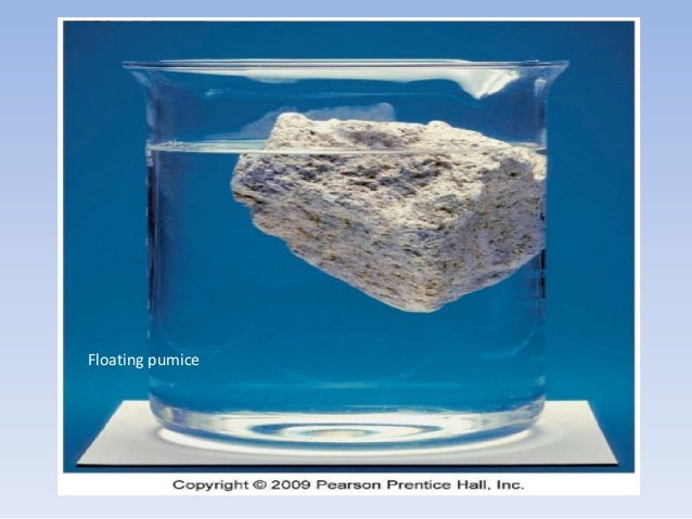 ?cb=1422602349
Oh yes. They have. A rock of one cubic meter has a buoyancy of one ton. So it is considerably easier to move underwater though its net buoyancy is still negative (unless it is volcanic pumice, which has a density lower than water:
What tty posted, plus the fact that very muddy water (such as in a flash flood, even moving along a nearly horizontal surface) has a specific gravity above 1.0. I could not find an on-line source for the maximum or even typical specific gravity of very muddy water, but I suspect it would be in the range of 1.5-2.0. The buoyancy force for a given rock volume will be proportion to the specific gravity of the fluid it is immersed in.
There are glacial erratics in New England (USA) that exceed 600 tons in weight – they were deposited there more than 9,000 years ago. In granite country, tors on top of hills can easily exceed 600 tons and these eventually end up in the drainages below.
We had one in our backyard in Connecticut where I grew up. They dug it up when the excavated for the basement. It was proably ~50 tons.
At least they do have a real climate change related story.
50 tons? That is nothing. Now this is what I call a glacial erratic:
http://media.tidningar.sveagruppen.se/sites/5/2015/07/Liten-och-stor-foto-Monika-Gustafsson.jpg
David, I grew up in Hamden, where were you?
“Guest eye-rolling by David Middleton”
Breaking: CAGW causing extreme eye rolling!
Twenty years ago, it was possible to say ‘science’ news can’t make so many eyes roll.
I think it’s causing extreme grave-turning as well.
Article #17-13233: “Storm, rogue wave, or tsunami origin for megaclast deposits in western Ireland and North Island, New Zealand?,” by John F. Dewey and Paul D. Ryan.
I didn’t know Paul Ryan had a PhD. What’s he doing studying boulders, when he’s Speaker of the House. And isn’t John Dewey the guy who invented the decimal point?
If a storm occurs where a poorly calibrated material is available to be mobilized, particularly if there is a large amount of more clay or silty material, any large block can be mobilized, and can even be a 600 tons easily. This is not because of climate change of cours. It happened in the past, it happens today and certainly will happen in the future, provided that the conditions of the place of drainage and the availability of sedimentary material allow it. This is related to the fact that the booster fluid ceases to be water but a mixture of water and sediment, becoming a non-Newtonian fluid. The viscosity of this fluid allows the transport of large particles. Any middle geologist knows this. The example pointed out in a previous commentary, which shows rocks to sustain coastal erosion, is not happy because although the seawaves can be very energetic, capable of mobilizing these blocks and destroying the defense structure, it can not mobilize them too much because the sediments in the breakzone and nearshore do not develop non-Newtonian fluids. In the zone where the waves dominate, the particles are mainly superior to 63 μm (silt and clay are bellow this dimension), in the domain of the sands or larger, and do not provoke this effect. In colder regions where glaciers dominate, the outwash currents from the glaciers, mixed with fine sediment and with a little help from the low temperatures (which help the fluid to become more viscous) large deposits of large particles, sometimes with several kilometers wide, are developed, called outwash plain deposits or Sandur.
JN If a storm occurs where a poorly calibrated material is available to be mobilized, particularly if there is a large amount of more clay or silty material, any large block can be mobilized, and can even be a 600 tons easily.
It’s not the storm that mobilizes it: it’s gravity; and I haven’t yet met the nut who denies that. The storm just provides the lower friction-coefficient toallow the force of gravity to achieve a net force that allows movement.. sort of like oil on a wheel, since clearly wet sludge is more slippery than dry dirt.
The question is: HOW COULD ANYBODY NOT KNOW THIS?
Ian, you are certainly right! Of course that the main “engine” it’s gravity. But it’s gravity and the mobilization of particles in a non-Newtonian fluid. Cheers
“large deposits of large particles, sometimes with several kilometers wide, are developed, called outwash plain deposits or Sandur.”
Sandurs are typically fine-grained sandy to silty deposits (I have several from the Younger Dryas near where I live). You may have been misled by the most famous Icelandic sandur Skeidhararsandur which is atypical since it is formed by Jökullhlaups, i e volcanic outburst floods, rather than ordinary periglacial processes like its eastern “neighbor” Breidhamerkursandur.
Yup tty, I was just thinking in that deposit! Went there in 2016. In most cases, the first part of the outwash deposits can have very large boulders. Those are the ones that ‘m referring too. Not only the ones from the terminal moraine. Of course, mostly of the Sandur deposits, mainly the most distal parts, I’ve saw large braided channels transporting large amounts of boulders. Some of them with impressive size.
Clearly the coal miners of Queensland – the same miners who killed all the polar bears on the Great Barrier Reef are now responsible for random localised gravity fluctuations in Ireland.
There is no real evidence that there has been a climate without strong storms. My Mother’s house is in a very benign area yet a recent storm there caused huge bolders to travel miles in a matter of hours. The lasd where she lives is all aluvial and some of the bolders imbeded in the ground are huge. The climate change we have been experiencing has been so small that it takes networks of very sophisticated insturments to even detect it and it is very difficult to distinguish climate change from normal weather cycles. There is no real evidence that the climate change we have been experiencing is responsible for anything let alone the movement of bolders.
Theoretically a very warm climate, like e. g. during the Eocene should be less stormy since temperature gradients were much weaker. However there is as far as I know no geological period without tempestites, i. e. storm deposits.
Thunderstorms depend on the amount of energy in the air(temperature and water vapor) along with the vertical temperature gradient.
“Any questions?”
Yes. How do I get a whole lot of money for garbage like that, too?
“Rocks don’t have buoyancy.” Wrong. Their weight is offset by the weight of the water their submerged volume displaces.
Found out what caused it! http://www.imdb.com/title/tt2494032/
Stonados.
If that boulder is on sand, I can move it downhill (i.e. “toward the sea”). Just takes a shovel and a moderate amount of time digging out the sand in front of it. And a tolerance of getting crushed if it rolls too far.
The kind of storms that moves these boulders is powered mostly by horizontal temperature gradient. When global temperature changes, the Arc temperature changes more than the temperature of the rest of the world. So global warming actually weakens this kind of storm. Note that these storms are most powerful during cold weather season, not summer.
The story about the Cow and the Bull and the other boulders from Eleuthera in Bahamas is spread around the world, to show the destructiveness and forces of superstorms. It`s an exiting story about what happened in superstorms 118000 years ago, when the wind and waves lifted boulders of up to 2300 tons ashore. The New Theory of Boulder Elevation came from a geologist Paul J. Hearty, and illustrate what we can expect if we don`t agree on a radical reduction of CO2 emission. This was really food for the climate scientist-activist James Hansen. “Hearty, an expert on Bahamas geology, first published in 1997 the idea that Cow and Bull and were hurled to their perch by the sea. Since then, Hansen has given the work much added attention by framing the boulders as Exhibit A for his dire view of climate change — which has drawn doubters in the scientific community.” ”That period was one where, in Hansen’s interpretation, “all hell breaks loose”: a collapse of polar ice, quickly rising seas, a shutdown of heat-transporting ocean circulation, and then superstorms spawned by a greater temperature contrast between warm tropics and cold poles.” Cited from: http://www.independent.co.uk/environment/megastorms-that-can-throw-thousand-tonne-boulders-up-cliffs-may-be-on-their-way-back-thanks-to-a6754511.html
What do we know about storms blowing rocks ashore?. We know it can happen. And we know about some instances. For the block at Bondi Beach the original source gives a weight of about 235 t. “Wave-transported during storm in 1912 (Süssmilch, 2012); often cited as an example for largest coastal boulder dimensions observed to have been moved during a storm (Felton and Crook, 2003; Switzer and Burston, 2010; Terry et al., 2013.)” From: Block and boulder transport in Eastern Samar (Philippines) during Supertyphoon Haiyan . S. M. May et al. Quite some difference between heaviest known boulder moved (235 tons) and the superstorm possible move (2300 tons). Ten times stronger waves than anytime during the last 105 years? And should the temperature contrast between warm tropics and cold poles be greater during a globally warm period than during some ice age?
“Hearty and another leading Bahamas geology expert, Pascal Kindler of the University of Geneva in Switzerland, agree that the boulders are older than the surface upon which they rest and, thus, probably were moved by the sea.” Kindler`s theory was that only a tsunami could move that big rocks. In 1996 Hearty wrote that it was possible that the boulders could have been moved by a tsunami. “The waves that transported the boulders may have been initiated by tsunamis, local slumping of the bank margin, or massive storms. The unidirectional flow generated by a tsunami is capable of transporting very large blocks, but if massive storms were responsible, they must have been much larger than those occurring during the Holocene. These findings may have important implications related to global warming during the present interglaciation.” This was forgotten a couple of years later, when it was only superstorms that counted. “ Chevron Ridges and Runup Deposits in the Bahamas from Storms Late in Oxygen-Isotope Substage 5e “. He then had two other geologists with him on The New Theory of Boulder Elevation, A. C. Neumann and D. S. Kaufman.
So, how was The New Theory of Boulder Elevation received among geologists? In 2002 there was presented a paper at The 114th Annual Meeting of the Geological Society of America. It was from the most profiled geologists of Bahamas. Boardman, Mark R., Carew, James L., Mylroie, John E., Panuska, Bruce C., Sealy, Neil E., and Voegeli, Vincent J.: Holocene deposition in Northwest Providence Channel, Bahamas : a geochemical approach. The conclusion was that Hearty and others hadn`t got the age right, and that the boulders was younger than the ground underneath. They had never been moved. “We regard the “boulders” to be residual karst towers, which explains the presence of the caves.”
Of couse Hearty and Hansen held on to The New Theory of Boulder Elevation. So, finally in 2016, when the Paris conference should be arranged, they gathered the climate scientist community around the paper: “Ice melt, sea level rise and superstorms: evidence from paleoclimate data, climate modeling, and modern observations that 2 ◦C global warming could be dangerous”. James Hansen1 , Makiko Sato1 , Paul Hearty2 , Reto Ruedy3,4 , Maxwell Kelley3,4 , Valerie Masson-Delmotte5 , Gary Russell4 , George Tselioudis4 , Junji Cao6 , Eric Rignot7,8 , Isabella Velicogna7,8 , Blair Tormey9 , Bailey Donovan10 , Evgeniya Kandiano11, Karina von Schuckmann12, Pushker Kharecha1,4 , Allegra N. Legrande4 , Michael Bauer4,13 , and Kwok-Wai Lo3,4 . But now with no other geologist than Hearty. But when he had to defend his new theory against his old co-worker Kindler, he came up with some new “geologists”. “Reply to Engel, Kindler, and Godefroid’s comment …” Paul J. Hearty , Blair Tormey, Bailey Donovan , and George Tselioudis. (geologist, master degree geology, geology student and adjunct professor physics) “There is near consensus that the megaboulders on Eleuthera were transported by giant waves around the end of the late last interglacial (end-Eemian; late MIS 5e), and we welcome validation of this conclusion by our colleagues.”
David Middleton. Perhaps you should investigate the case a little better before you spread the fairytales of Hearty and Hansen.
The point is that >50 ton boulders are routinely pushed around by storm-driven waves.
““Ten years ago, it was possible to say storms can’t move 50 ton boulders,” lead study author Rónadh Cox, a professor of geosciences at Williams College, told Earther.”
Cox should know that this is not true. Süssmilch gave out his observations in 1912. And was referred to later, as by Felton and Crook, 2003.
Note on Some Recent Marine Erosion at Bondi. Volum 46 av Jour. and Proc, Roy. soc. of New South Wales
Carl Adolph Süssmilch, 1912.
Any geologist should know that Cox’s assertion was ridiculous.
I have been following Hearty’s publications for a long time and the description above is essentially correct.
Great to know that this phenomena pre-dates the start of “man made climate change” ………
“The most sublime scene is where a mural pile of porphyry, escaping the process of disintegration that is devastating the coast, appears to have been left as a sort of rampart against the inroads of the ocean. The Atlantic, when provoked by wintry gales, batters against it with all the force of real artillery- the waves having, in their repeated assaults, forced for themselves an entrance. This breach, named the Grind of the Navir, is widened every winter by the overwhelming surge, that, finding a passage through it, separates large stones from its sides, and forces them to a distance of 180 feet. In two or three spots the fragments which have been detached are brought together in immense heaps, that appear as an accumulation of cubical masses, the product of some quarry.” Hibbert-Ware (1822)
https://www.earthmagazine.org/article/travels-geology-scotlands-stunning-shetland
http://www.landforms.eu/shetland/grind%20of%20the%20navir.htm
1 cubic meter of water weighs 1 metric tonne. Add inertia to that, 1T at say 30kph, then multiply that by several thousand results in enough energy to move mountains.
When water flows in a big way, best get out of its way.
Aw c’mon guys, where’s yer sense of hmuor? Gallantry even. Self awareness.
Maddie is trying to help.
Maddie sincerely has the very best of intentions and desperately wants The World nice nest for her (future?) babies. I’ll get a slap for saying this but “That’s what girls do”
Have you *seriously* got a problem with that?
Hope not.
Almost the entire reason Maddie comes unstuck is with the education she received.
And who was responsible for that, if not the generation above her.
No chance it was that thing you see in a mirror was it………
(Try not to pass any bucks while pondering that)
I remember a granite slab I mapped back around 1989 in southern Nova Scotia. It was `around’ 150 m long, 10 m high, and around 40 m wide. It was moved as a coherent slab during a minor re-advance of the last ice sheet and deposited on top of glacial outwash (sand and gravel for the non geologists). So at 2.68 mt per cubic metre it works out to be 60,000 mt…..BIG. But that is glaciers, were talking about wave action.
Lets assume that in the paper (which I haven’t read), that the researchers measured the actual position of the boulders, not the position of the boulders relative to the shoreline, e.g as an example the base of a cliff. Cliffs erode, and if that was the case the boulder movement could be, or could be partially movement of the cliff face. I am being mean as I,m sure the researchers aren’t that stupid…… though I have seen many examples of environmental studies folks, or other `experts’ working outside their fields of `expertise` making incredibly stupid claims.
Mapping along cliffs, quantifying coastal erosion, I have seen many boulders move seaward…. it is what boulders do. Waves do not need to move the boulder, they erode sand, gravel, cobbles, other smaller boulders around the base and under the boulder and the boulder moves down slope…gravity as many people mentioned. This is something that a student would learn in first year geology.
Also remember that the force of a breaking wave is much, much, much greater than a non breaking wave in a marine setting. In the marine setting the energy of a non breaking wave simply moves through the water….there is little movement of the actual water. However when a wave breaks, the force in which it hits an object is incredible. Remember the old F = ma. When the wave breaks the m is the mass of the actual water. In a non breaking wave the mass is very little. So things such as high or low tide can have a big effect on say movement of the boulder. Just the right tide height so that the waves break against the boulder, and scour at the base, along with loss of effective weight in water…. and away it goes.
Wish I could be `published’ for discovering that boulders move from the top to the base of a beach. sarc.
Climate Change stole my dingo.
The doomsday clock just moved to: two boulders to midnight and it is scary
The moving stones are Ogri, silicon based life forms from the planet Ogros in the Tau Ceti system.
Dr. Who – The Stones Of Blood episode