
Guest essay by Eric Worrall
h/t James Delingpole / Breitbart – University of Manitoba has a new term for excess sea ice; they now call it “climate change”.
Large Canadian Arctic climate change study cancelled due to climate change
The Science Team of the Canadian Research Icebreaker CCGS Amundsen has cancelled the first leg of the 2017 Expedition due to complications associated with the southward motion of hazardous Arctic sea ice, caused by climate change.
This regrettably postpones the much-anticipated Hudson Bay System Study (BaySys) involving 40 scientists from five universities across Canada. Timing was key for this $17 million, four-year, University of Manitoba-led project.
The need to deal with extreme ice conditions in the south meant the ship would arrive too late on site to meet research objectives.
…
The decision to terminate the 2017 program has significant impacts on partners and the large number of graduate students involved.
“Considering the severe ice conditions and the increasing demand for Search And Rescue operations (SAR) and ice escort, we decided to cancel the BaySys mission. A second week of delay meant our research objectives just could not be safely achieved – the challenge for us all was that the marine ice hazards were exceedingly difficult for the maritime industry, the CCG, and science,” says Dr. David Barber, Expedition Chief Scientist and BaySys Scientific Lead.
…
Read more: http://news.umanitoba.ca/large-canadian-arctic-climate-change-study-cancelled-due-to-climate-change/
At least we now have an answer to the question “What do Arctic researchers do if they are stuck in port for two weeks?”. The answer is they find new ways to torture the English language.
Yea, the acolytes are blaming the proliferation of ice on global warming. It is hilarious to watch them twist hot and cold to conform to their narrative.
Was that intrepid Antarctic explorer Chris Turney involved?
philjourdan
Please refer to the original story (from James Delingpole’s link): http://www.winnipegfreepress.com/local/u-of-m-climate-change-study-postponed-due-to-climate-change-428030543.html
No one is suggesting a “proliferation” of Arctic sea ice this year. All indicators are that Arctic sea ice is currently at about it’s 3rd lowest extent on record for this time of year.
The ice in question is multi-year ice from much further north in the Arctic. It broke off from there and drifted south across open water, ending up on the north coast of Newfoundland Island where it trapped some fishing vessels. The scientists’ ship happens to be an ice-breaker, so the Canadian Coast Guard diverted it from its research mission in Hudson Bay to assist with the situation in Newfoundland.
So it’s the breaking up and drifting of the thick, multi-year ice in the high Arctic that the scientists are referring to when they say their research was interrupted by ‘global warming’.
However, as happens every year after mid-August (August 12 was the date Dr Curry observed re-freezing each night of lead water), exposed open ocean waters lose more heat over 24 hours of exposure than is gained by solar absorption during the ever-shortening arctic daylight.
You may want to read Dr. Susan’s post above. Perhaps Barber isn’t the expert he pretends to be
Silly nonsense, Griff. The ice would have to cross over islands or through completely blocked and very small gaps for your claim to be correct. But hey, we already knew you were delusional so this claim is not at all surprising.
Except this year they are not blocked as is shown by satellite imagery. Here’s the path that is followed as illustrated by the track of a very large ice island (60m thick, ~250km^2) from the Petermann glacier a few years ago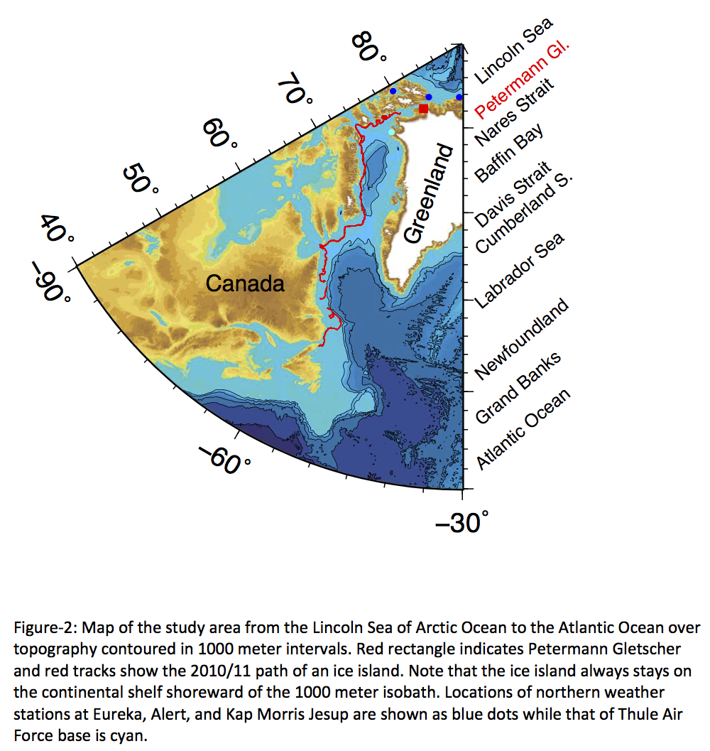
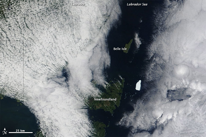
Here’s a shot of a remnant of the ice island off the coast of Newfoundland (where you claim it can’t get to), note it’s as big as Belle Isle.
Sorry Phil., but the Nare’s Straight is too narrow to move much ice through and it is blocked by the thickest multiyear ice to its north. You might get a few chunks of ice to make it through but nothing substantial. Your pictures tell us nothing of ice movement throughout the year.
http://osisaf.met.no/p/osisaf_hlprod_qlook.php?year=2017&month=03&day=13&prod=Ice-Type&area=NH&size=25%25
Most of the ice around Newfoundland is much more likely to be home grown or from Greenland glaciers calving. With the large SMB increase in Greenland this year I wouldn’t be surprised if there hasn’t been more calving of glaciers.
Richard M June 15, 2017 at 9:18 am
Sorry Phil., but the Nare’s Straight is too narrow to move much ice through and it is blocked by the thickest multiyear ice to its north. You might get a few chunks of ice to make it through but nothing substantial. Your pictures tell us nothing of ice movement throughout the year.
If you were talking about this time last year you would be right. However, this year it is not blocked and that ‘thickest multiyear ice to its north’ is completely broken up and is flowing through the Nares Strait. Here is a shot from the beginning of this month and you can see the fractured ice at the mouth of the strait (which is ~27km wide), observations have shown those fragments moving throughout at about 15km/day. You can get a better look at the image by clicking on the 250m pixel size.
Phil,
The Petermann Glacier is already well into the Nares Strait, so its passage says nothing about Arctic Ocean ice trying to get into Baffin Bay.
Good grief, Phil. I gave you a link where you can look at the ice each and every day. They show no multi-year ice of any substance flowing through the Nare’s Strait. They do show thick ice forming off of Greenland in early May. Most likely it is exactly what Susan described.
Richard M June 15, 2017 at 12:44 pm
Good grief, Phil. I gave you a link where you can look at the ice each and every day. They show no multi-year ice of any substance flowing through the Nare’s Strait.
My original reply to this disappeared so here’s another shot.
I suggest that you use a site where the resolution is adequate to see the ice flowing through the Nares.
The one I use is:
https://lance3.modaps.eosdis.nasa.gov/cgi-bin/imagery/realtime.cgi
You’ll see that the multiyear ice in the Lincoln sea that normally blocks the entrance to the Nares strait was already broken up and flowing into the strait in early May, and still is.
“You’ll see that the multiyear ice in the Lincoln sea that normally blocks the entrance to the Nares strait was already broken up and flowing into the strait in early May, and still is.”
Phil, I strongly suggest that you read up on the North Water polynya. In some years (e. g. in 1881 and 2017) it extends all the way north to the Fort Conger area. But it does not do so reliably as the Greely expedition found to its cost in 1882-84.
tty June 16, 2017 at 2:30 am
“You’ll see that the multiyear ice in the Lincoln sea that normally blocks the entrance to the Nares strait was already broken up and flowing into the strait in early May, and still is.”
Phil, I strongly suggest that you read up on the North Water polynya. In some years (e. g. in 1881 and 2017) it extends all the way north to the Fort Conger area.
Yes I’m well aware of the North Water, which has nothing to do with the point I made.
DWR54,
Obviously you did not read Dr. Crockford’s chronicle (linked above).
Your blathering about multi-year ice drifting down from the high arctic is hogwash.
Read her article, then come back here and issue your retraction. Right now you’re looking like a fool.
WBWilson
Having re-read it I have to say you’re right about the ‘multi-year’ bit. I got that from Dr Crockford’s article, who says Dr Barber claimed that’s what it was. The WFP article doesn’t actually quote Barber or anyone else as stating that it was multi-year ice. What it says is that the ice they encountered wasn’t the “usual sea ice”, but “thicker ice from further north”, which fits with the information posted by Dr Crockford re the wind-driven movements of icebergs, etc this spring.
It seems there is a localised proliferation of ice at this area of Labrador and Newfoundland caused by drifting ice from further north. However, it remains the case that, overall, Arctic sea ice is currently at its 3rd lowest extent on record for this time of year. That’s according to DMI, NSIDC and JAXA, all of which carry out independent analysis of satellite data.
DWR54 (at 8:21 am),
Sorry, you don’t get to concede that Barber was probably wrong about the composition of the ice and then claim he was nevertheless right overall.
This incident had nothing to do with the extent of global ice, whether it was the “3rd lowest” or not.
The premise of the all the stories that have been written about this incident has been that Barber’s climate change research was scuttled because of climate change.
It wasn’t: his research was derailed because of localized ice conditions (aka, weather) that could have happened any year. It meant the icebreaker he was counting on for transport and lodging was diverted to deal with thick ice in an area Barber had not expected to encounter it – bad luck, that.
He took advantage of the situation for his own purposes and in the process, misrepresented science.
He didn’t need to issue a press release but he did: he did it to garner publicity for his project, himself, and his cause.
He got so wrapped up in his own rhetoric and practiced hyperbole about declining Arctic ice that he did not make himself clear to reporters and in the process, he did a disservice to his science colleagues everywhere and made himself look silly.
You say: “It seems there is a localised proliferation of ice at this area of Labrador and Newfoundland caused by drifting ice from further north.” But it was NOT thick multiyear ice that drifted down from the north, since it does not show up on the charts – what drifted down was icebergs offshore and thin first year ice close to shore that thickened because of cold local conditions in the region. Newfoundland and Labrador are COLD in the winter and early spring!
Icebergs are not multiyear ice pack ice from the High Arctic: they are bits of glacier ice from the High Arctic and they routinely show up around Newfoundland and southern Labrador every year (so routinely that an entire tourist industry is built around their appearance). The Titanic was sunk by one in 1912.
What was new this year was the storm that mixed the icebergs in with the thick first year ice and compacted it against the shore of Newfoundland and into the Strait of Belle Isle.
Barber’s research expedition was not a victim of climate change or even declining Arctic sea ice. It was just bad luck.
“He took advantage of the situation for his own purposes and in the process, misrepresented science.”
That’s exactly what he did!
susanjcrockford June 15, 2017 at 11:29 am

DWR54 (at 8:21 am),
You say: “It seems there is a localised proliferation of ice at this area of Labrador and Newfoundland caused by drifting ice from further north.” But it was NOT thick multiyear ice that drifted down from the north, since it does not show up on the charts – what drifted down was icebergs offshore and thin first year ice close to shore that thickened because of cold local conditions in the region. Newfoundland and Labrador are COLD in the winter and early spring!
It wasn’t just Barber who said that:
“Five fishermen were rescued Wednesday from the Avalon Princess fishing boat, which started to take on water after getting stuck in thick sea ice near La Scie, N.L.
Trevor Hodgson, the Canadian Coast Guard’s superintendent of ice operations for the Atlantic region, said the heavy ice is more than two metres thick in some areas off the province’s northeast coast.
“We had a bit of stuff that forms over the winter, the normal ice in the area,” he said. “What we’re experiencing now is the ice that has come south through the Arctic due to melting up there.”
What’s unusual this year, Hodgson said, is the way the winds have pushed the thick pack ice towards land rather than out to sea.
Newfoundland and Labrador may be cold but not cold enough to produce more than 2m thick ice in the season.
Also the ice that’s been blown there doesn’t look much like icebergs:
There are plenty of icebergs blown there but that’s not the problem:
3rd lowest. Since 1979?
Is that before the huge growth of Arctic sea ice during the 60s and 70s, that started the whole ” coming ice age” scare?
Yeah, they should have started about 1972 instead of 1979. Things would look a lot different.
Or earlier than 1972 for that matter:
Here’s another view:
Pls cut through the crap:
In 2007 the world was told that by approx. 2014 we would have an ice fee Arctic caused by man-made global warming,
Based on best available verifiable empirical data from countries ranging from Canada through Denmark, Norway, Russia and the US, at the 2016 September minimum there was enough ice – a good volume of which we know was multi-year ice, i.e. hard and therefore older – to cover 60% of Canada / 85% of Australia, take your pick.
The rest is socio-political CAGW/CACC propaganda and should be tackled only on those terms.
storms bunched up arctic ice during winter which was sold as melting, here is all the extra ice making fools of these scintsts, not a typo
Stop burning coal and oil and save the ice. Also, Ice is bad.
Solar EUV is at record low levels for comparable Solar Cycles [in the Solar Cycle 11 year sequence].
Solar EUV causes Ozone. The Ozone layer has moved lower in the upper atmosphere.
The protective Ozone blanket is thinning. This lets more energy [heat] escape to space.
Global temperature change: -0.1C/2.5 years due to decreased Ozone.
This means -0.3C Global temperature decrease at the beginning of Solar Cycle 25.
OOPS: more climate change!
We need more CO2 …
EUV is absorbed very high up in the atmosphere, the wavelengths important for creating the ozone layer are in the UVC band not the EUV.
There are two factors here. More ultraviolet light helps form ozone from O2 in the upper atmosphere.
That additional ozone blocks some of the incoming infrared light from the sun from directly reaching the surface. The net effect with more ozone is a SMALLER greenhouse effect.
We all know that the term climate change ony came about because the global warming term seemed inappropriate in a world not actually warming. “Climate change” was thus always meaningess as a synonym for global warming. All part of the non-scientific views by a bunch of people pineing to become “planet saviors,” just lacking a planet to save.
“But Barber said once out on the water the scientists realized this wasn’t the usual sea ice, which would be relatively easy for the icebreaker to plow through, but thicker ice from further north which had broken off because of climate change.”???
http://www.winnipegfreepress.com/local/u-of-m-climate-change-study-postponed-due-to-climate-change-428030543.html
ftp://sidads.colorado.edu/DATASETS/NOAA/G02186/latest/4km/masie_all_zoom_4km.png
ftp://sidads.colorado.edu/DATASETS/NOAA/G02186/plots/4km/r08_Baffin_Bay_Gulf_of_St._Lawrence_ts_4km.png
ftp://sidads.colorado.edu/DATASETS/NOAA/G02186/plots/4km/r11_Central_Arctic_ts_4km.png
Sea Ice Extent Minimum.


The DMI ice temperature product (IST) uses three thermal infrared channels from the Advanced Very High Resolution Radiometer (AVHRR) on board the Metop-A satellite to calculate the surface temperatures in the Arctic.

http://images.tinypic.pl/i/00909/d1uvhcxoc1b2.png
Daily mean temperatures for the Arctic area north of the 80th northern parallel, plotted with daily climate values calculated from the period 1958-2002.
http://ocean.dmi.dk/arctic/plots/meanTarchive/meanT_2017.png
My Alma mater! Where they used to do real research. At least up to the 1960s Manitoba produced more petroleum geologists than any other Canadian University. Their Engineers (me among them) worked on the world’s second largest excavation after the Panama Canal- the Greater Winnipeg Floodway. In my hydrogeological work in southwest Manitoba, I discovered the extension of the north-flowing, preglacial Missouri River at a depth, IIRC, of a couple of hundred feet – identified by tan quartz pebbles, petrified wood pebbles and opalized wood. Dr. G. Brownell invented the scintillometer and airborne scintillometer and the ‘beryl meter for mineral exploration. Dr Baracos University of Manitoba in the 50s-70s, a highly decorated engineer, was, I believe, the first to calculate the maximum thicknesses of the ice sheet of the last glacial max using the principle of the triaxial stress ‘memory’ based on the Mohr Circle on pre glacial soils. Perhaps it might be interesting to do a post on how this is done.
Dang can’t make link with cell. See wiki.
+10…interesting!
Funniest is when they say that they expect conditions to get worse in the future. There you have it: climate change will cause more and more ice.
So. Researchers can only safely go to a site in the Arctic with no sea ice. Therefore anywhere they go they will find no ice. The conclusion is clear: sea ice is disappearing.
Is science not wonderful?
https://polarbearscience.com/2017/06/12/heavy-ice-off-east-coast-2017-caused-by-winds-cold-temperatures-and-icebergs/
Dr. Crockford’s comment should be elevated to a post update at least since it is both informed and informing more than simply quoting the Manitoba press.
Thank you.
Nothing less than stasis will satisfy their unease.
Nothing less that Statism will satisfy their desire.
Stalinism
After so many of exactly these kinds of incidents, it’s only natural that they would fall back on their standard ‘call it something else’ strategy – I’m just amazed it took this long. Probably, because it was too outrageous to try before – of course, at this point, they’re beyond caring.
What’s with the ice breaker and not the Mediterranean yacht anyway? Don’t these people get their own computer modelling?
Alarmist scientists have their fingers caught in their post-2007 predictions of Arctic sea ice doom due to climate change. Now Arctic sea ice has refused to melt for the past 10 years and so they have fabricated a new unnecessary pause through their alarmism. They are responding with fake propaganda and fake modeled volume, yet the ice refuses to go and keeps trapping ships.
I doubt we will have a record low this September as the melting and the temperatures have been both below average so far. Weather might have something to say to this. Since we have the big 2016 El Niño at our back, and the planet has been cooling since, I expect Arctic sea ice to continue its recovery over the next few years, much to the dismay of sea ice alarmists.
So expect lots of climate change affecting Arctic sea ice.
Arctic sea ice coverage is counter-intuitive: It definitely does NOT follow the long-cherished “Arctic death spiral” of CAGW theorists. In that catastrophic death spiral, loss of arctic sea causes increased solar energy absorption, which causes warmer Arctic ocean temperatures, which causes even more arctic sea ice losses, which ever-more open ocean to absorb solar energy, which causes …
Rather, low (below “average”) sea ice anomalies in the spring (Feb-Mar-Apr) maximum usually are followed by very low fall (Aug-Sep-Oct) minimums.
Very low and record low fall minimums are almost always followed by very high spring maximums!
High early summer and summer (Apr-May-June) anomalies are followed by very low fall (Aug-Sep-Oct) minimums. (Death spiral fantasies would require the opposite be trend be seen in both cases.)
Small sea ice anomalies in early winter and mid-winter (Oct-Nov-Dec-Jan) are generally followed by smaller sea ice anomalies in the subsequent spring and summer.
It seems more accurate to follow a “sea ice insulation” theory: Most of the year, removing the Arctic sea ice removes an insulating and reflective blanket between the warm arctic ocean waters and the freezing arctic air mass and the infinitely cold space above. This increases heat loss from the arctic ocean all year long, but significantly warms the arctic air mass due to increased evaporation and convective loss in winter. In the short arctic summer, the arctic ocean warms slightly due to increased solar energy absorption around noon each day, but not enough to overcome the year-long losses at twilight each night and evening.
The actual “average” arctic ocean extents are unknown, but very unlikely to be those found using the satellite era’s 1979 high point used to “anchor” the traditional CAGW-sponsored) 1980-2010 “average sea ice decline” linear charts. Expect a 66-70 year cycle to become obvious in the next few years.
RACookPE1978 June 15, 2017 at 11:20 am
Arctic sea ice coverage is counter-intuitive: It definitely does NOT follow the long-cherished “Arctic death spiral” of CAGW theorists. In that catastrophic death spiral, loss of arctic sea causes increased solar energy absorption, which causes warmer Arctic ocean temperatures, which causes even more arctic sea ice losses, which ever-more open ocean to absorb solar energy, which causes …
Rather, low (below “average”) sea ice anomalies in the spring (Feb-Mar-Apr) maximum usually are followed by very low fall (Aug-Sep-Oct) minimums.
Very low and record low fall minimums are almost always followed by very high spring maximums!
So last fall was the 2nd lowest minimum and was followed by the record low spring maximum.
Second lowest, since the record high that also corresponded with the beginning of the satellite era.
The big El Nino was the cause of the low ice levels, as El Ninos always do.
Why don’t you try telling the whole truth, not just the tiny sliver that supports your myth making?
Phil. June 15, 2017 at 6:44 pm
Last year was a super El Nino year. And the maximum was just barely lower than last year’s and other recent maxima.
We’ll see what happens this year. Right now Arctic sea ice extent is about average for this date during the past five years.
My kayak and I will see them through their trials.
“The need to deal with extreme ice conditions in the south meant the ship would arrive too late on site to meet research objectives.”
Guess that translates to they had to pull-up-short for the need to vomit out the beer, scotch and schnapps and take a pee and dump on the sea ice before starting the “return” leg.
Jajajajajajajajaja
Instead of cancelling the 2017 study due to excess ice, shouldn’t they be making a start on the 2018 study, ensuring they make it there in time? Hopefully someone is raisin this issue with them
Since the ship of fools I bet insurance has become more expensive for these jaunts in icy waters. A bunch of academics plus students who rock up with a boat, and expect to go where they want when they want, is a high risk.
excess sea ice they call it “climate change”, less sea ice they call it “global warming”
Susan Crockford posits that the “Multi-year ice” is actually a combination of first year ice and impacted icebergs from Greenland. Barber’s team admitted that they “Have never seen high arctic ice before”, and of course, now they are experts. https://polarbearscience.com/2017/06/12/heavy-ice-off-east-coast-2017-caused-by-winds-cold-temperatures-and-icebergs/
They would be well advised to read the report of the Nares expedition in 1874 which was the first to reach the north coast of Ellesmere land and come into contact with multi-year ice (which they called “palaeocrystic ice”). Their descriptions and illustrations are excellent and quite insightful about the processes active in the formation of multi-year ice. However like most early arctic research it seems to have been completely forgotten by the current generation of “climate scientists”.
etudiant June 15, 2017 at 1:22 pm
Thank you for this very informative link. It seems plausible that the Barber team, lacking field experience, mistook compacted ice for multi year ice.
It seems totally implausible that that is the case since Barber has made 35 Arctic field trips, he certainly knows the difference. Also they sampled the ice and tested it in the lab so certainly would be able to distinguish between FYI and MYI.
It’s much more plausible that the report omitted the word ‘here’.
There is a report quoted above which includes this statement:
‘Barber’s crew decided to take advantage of the opportunity to examine bits of iceberg ice trapped in pack ice, even though they’d never seen Arctic ice before.’
That is the basis of my comment.
Separately, differentiating between compressed local ice and rafted multi year ice from further north seems to rely on accumulated dirt in multi year ice. Is this a reliable indicator?
etudiant June 15, 2017 at 6:37 pm
There is a report quoted above which includes this statement:
‘Barber’s crew decided to take advantage of the opportunity to examine bits of iceberg ice trapped in pack ice, even though they’d never seen Arctic ice before.’
That is the basis of my comment.
That isn’t a quote from the report it’s Susan’s sarcasm.
From another report:
“Barber, a climate change scientist at the University of Manitoba, and the other scientists did what they could to help the Coast Guard rescue the vessels and carved a path for the tankers. They also took the time to study the ice that surrounded them, discovering that much of it was the multiyear ice typically seen in the high Arctic.
It was an unexpected find, said Barber, given the time of year and how far south they were. “It’s not something you would expect to see there and not something we’ve seen there before,” he said.
Some of the other reports appear to have omitted the ‘there’ which totally changes the meaning, as I pointed out above to use that to imply that Barber with 35 expeditions in the Arctic doesn’t know what MYI is, is clearly an error.
Separately, differentiating between compressed local ice and rafted multi year ice from further north seems to rely on accumulated dirt in multi year ice. Is this a reliable indicator?
I’d expect them to measure salt content, multiyear ice being lower in salt content.
“Multiyear ice has distinct properties that distinguish it from first-year ice, based on processes that occur during the summer melt. Multiyear ice contains much less brine and more air pockets than first-year ice. Less brine means “stiffer” ice that is more difficult for icebreakers to navigate and clear.” NSIDC
RE Phil
***It seems totally implausible that that is the case since Barber has made 35 Arctic field trips, he certainly knows the difference. Also they sampled the ice and tested it in the lab so certainly would be able to distinguish between FYI and MYI.
It’s much more plausible that the report omitted the word ‘here’.***
Phil, it does not matter how many field trips barber has made, He says what is to his advantage. He has called Arctic ice “rotten, after sailing in a small area. Now, he says melting and stronger winds have blown the ice southward. here you guys are talking about multi-year ice, but you should recall he was talking abut “thin” ice, so which is it?
You said they tested it. really??
Gerald Machnee June 16, 2017 at 5:10 pm
RE Phil
***It seems totally implausible that that is the case since Barber has made 35 Arctic field trips, he certainly knows the difference. Also they sampled the ice and tested it in the lab so certainly would be able to distinguish between FYI and MYI.
It’s much more plausible that the report omitted the word ‘here’.***
Phil, it does not matter how many field trips barber has made, He says what is to his advantage. He has called Arctic ice “rotten, after sailing in a small area.
He used that term to describe the ice he was sailing through in the Beaufort Sea, which although it appeared to be solid Multiyear ice to the satellite turned out to be fragmented MYI joined by thin FYI, and was therefore much weaker.
Now, he says melting and stronger winds have blown the ice southward. here you guys are talking about multi-year ice, but you should recall he was talking abut “thin” ice, so which is it?
Describing the ice on the opposite side on the continent, the thickest remaining MYI is pushed against the northern coastline towards Ellesmere Island and Greenland, which is where he suggested this ice came from.
You said they tested it. really??
You have a research vessel completed fitted out with labs with a research team on board diverted from their original mission, of course they tested it!
“Dr. Barber and his team of experts were able to use the state-of-the-art equipment onboard the Amundsen to confirm that a significant proportion of the sea ice present originated from the high Arctic.
The Sea Ice Research Team collected a comprehensive dataset on the physics of the ice, ocean and atmosphere in the area and these data will contribute to the understanding of these events and assist Canada in preparing for climate change driven increases in marine ice hazards.”
RE Phil:
***You said they tested it. really??
You have a research vessel completed fitted out with labs with a research team on board diverted from their original mission, of course they tested it!***
Of course they tested it! – Hear say.
***“Dr. Barber and his team of experts were able to use the state-of-the-art equipment onboard the Amundsen to confirm that a significant proportion of the sea ice present originated from the high Arctic.***
So what do you mean by High Arctic? Exactly where? Phil, you are saying from Ellesmere Island and Greenland. And that was multi-year ice??? Sure. If you listen to his radio interview he said the ice was “thin” and was blown out by stronger winds caused by climate change. So is that multi-year ice, thin ice, or ice broken off glaciers. Are you trying to tell me that there was thick ice on the east side of Ellesmere Island? Bullwinkle!
**The Sea Ice Research Team collected a comprehensive dataset on the physics of the ice, ocean and atmosphere in the area and these data will contribute to the understanding of these events and assist Canada in preparing for climate change driven increases in marine ice hazards.”**
Comprehensive dataset? Let’s see it.
Phil. has spent a decade working on his “tap dance around the truth” routine. Sad, really.
Gerald Machnee June 17, 2017 at 6:31 pm
RE Phil:
***You said they tested it. really??
You have a research vessel completed fitted out with labs with a research team on board diverted from their original mission, of course they tested it!***
Of course they tested it! – Hear say.
Not hearsay, they actually reported that they made such measurements!
***“Dr. Barber and his team of experts were able to use the state-of-the-art equipment onboard the Amundsen to confirm that a significant proportion of the sea ice present originated from the high Arctic.***
So what do you mean by High Arctic? Exactly where? Phil, you are saying from Ellesmere Island and Greenland. And that was multi-year ice??? Sure. If you listen to his radio interview he said the ice was “thin” and was blown out by stronger winds caused by climate change. So is that multi-year ice, thin ice, or ice broken off glaciers. Are you trying to tell me that there was thick ice on the east side of Ellesmere Island? Bullwinkle!
The presence of quotation marks indicates that the phrase ‘high arctic’ originated in the article and was not my choice of words. However others have referred to the source of the thick ice found off Labrador and Newfoundland, for example Andreas Münchow:
“The thickest ice off Labrador and Newfoundland (excluding icebergs) originates mostly in the Lincoln Sea and passes south through Nares Strait.”
He has extensively studied this and a recent paper describes ice draft measurements in the Nares strait from 2003 through 2012 .
When there was no ice bridge (like this year) they found:
“Median ice draft then was at its maximum during our 9 year observational period reaching 1.98 m while the 95th percentile draft exceeded more than 8 m. We conclude that the absence of any ice arch resulted in the southward export of a record volume of sea ice to exit the Arctic Ocean via Nares Strait. ”
http://muenchow.cms.udel.edu/papers/RyanMuenchow2017.pdf
**The Sea Ice Research Team collected a comprehensive dataset on the physics of the ice, ocean and atmosphere in the area and these data will contribute to the understanding of these events and assist Canada in preparing for climate change driven increases in marine ice hazards.”**
Comprehensive dataset? Let’s see it.
Well no doubt they will present it and write it up but their preliminary findings have been reported:
“Dr. Barber and his team of experts were able to use the state-of-the-art equipment onboard the Amundsen to confirm that a significant proportion of the sea ice present originated from the high Arctic.”
Thank you for this very informative link. It seems plausible that the Barber team, lacking field experience, mistook compacted ice for multi year ice.
I’d think that the AGW proponents here would be better served focusing on the unusually high number of icebergs, as these reflect increased ice loss from the Greenland glaciers. Is there any ongoing documentation of West Greenland ice loss?
If memory serves, there were recent reports of hazardous waste dumps getting exposed dating back to old military base from the cold war.
That might be an area that has been monitored reasonably consistently which could help improve our understanding.
“If memory serves, there were recent reports of hazardous waste dumps getting exposed dating back to old military base from the cold war.”
That is pure scare-mongering like most CAGW propaganda. Camp Century is situated in an accumulation area that has been continually ice-covered for at least a million years.
http://adsabs.harvard.edu/abs/2014EGUGA..1610721F
It is however south of the ice-divide, so in a few thousand years it will probably calve inte Melville Bay.
Etudiant
Is there any documentation of west Greenland ice loss?
Yes there is:
http://beta.dmi.dk/en/groenland/maalinger/greenland-ice-sheet-surface-mass-budget/
It’s negative loss. Greenland is gaining mass of ice and snow at the surface (where it matrers).