Studies refute hypothesis on what caused abrupt climate change thousands of years ago
Two new studies in the Journal of Quaternary Science refute the hypothesis that one or more comets/bolides struck North America approximately 12,900 years ago triggering rapid climate change and the start of the Younger Dryas period.
Prior to the Younger Dryas, the climate had gradually warmed from glacial conditions to near modern temperatures, and the massive ice sheets in North America were in full retreat; however, approximately 12,900 years ago, temperatures rapidly plummeted and returned to glacial conditions for about a 1200 year long period. Also about this time, the mammoths and mastodons became extinct in North America.
The two papers challenge two lines of evidence reported and used by others to support the impact theory. One is the report of elevated concentrations of nanometer-sized diamonds in sediments deposited at the onset of the Younger Dryas. It is claimed that these diamonds were formed during an impact. The other is the interpretation that paleofire evidence at a key archaeological site demonstrates massive wildfires at the beginning of the Younger Dryas. It is claimed that the impact caused wildfires that spanned the continent.
Each paper shows that the evidence and interpretations supporting these two lines of arguments do not stack up.
“Impact proponents report the rare form of diamond, lonsdaleite, that is usually associated with shock processing; however, we show that they misidentified polycrystalline aggregates of graphene and graphane as lonsdaleite,” said Dr. Tyrone Daulton, lead author of one of the papers. “Further, we show that the nanodiamond concentration measurements reported by impact proponents are critically flawed. There is no evidence for a spike in the nanodiamond concentration at the onset of the Younger Dryas to suggest that an impact event occurred.”
Prof. Andrew Scott, lead author of the second paper said, “The idea of a Younger Dryas impact was an interesting one that has drawn much attention; however, increasingly methodological research over the past few years has failed to corroborate that story. Our research has shown that many of the markers for such an event have been misinterpreted or misidentified.”
###
Studies: http://onlinelibrary.wiley.com/doi/10.1002/jqs.2892/full
http://onlinelibrary.wiley.com/doi/10.1002/jqs.2914/full
The case of the missing diamonds
Unproved, Washington U. sleuth says of Younger Dryas impact
It all began innocently enough. Tyrone Daulton, a physicist with the Institute for Materials Science and Engineering at Washington University in St. Louis, was studying stardust, tiny specks of heat-resistant minerals thought to have condensed from the gases exhaled by dying stars. Among the minerals that make up stardust are tiny diamonds.
In 2007, Richard Kerr, a writer for the journal Science, knowing Daulton’s expertise, called to ask whether nanodiamonds found in sediments could be evidence of an ancient impact.
Daulton said it was possible the heat and pressure of such a cataclysm could convert carbon in Earth’s crust to diamond, but asked to see the paper, which had been published in Science.
The Science paper argued that a shower of exploding comet fragments over the North American ice sheet had triggered a sudden climate reversal called the Younger Dryas. Having read the paper, Daulton told the reporter, “It looks interesting, [but] there’s not enough information in this paper to say whether they found diamonds.”
Since then, Daulton has periodically been asked to evaluate Younger Dryas sediments for nanodiamonds. In the issue of the Journal of Quaternary Science released online Dec.19, he reviews the accumulated evidence and reports on his own analysis of new samples from California and Belgium.
For the second time in 10 years, Daulton has carefully reviewed the evidence, and found no evidence for a spike in nanodiamond concentration in Younger Dryas sediments. Since nanodiamonds are the strongest piece of evidence for the impact hypothesis, their absence effectively discredits it.
And so a great idea apparently has been brought low by the humblest of evidence.
What went wrong?
Nanodiamonds, it bears emphasizing, are tiny — smaller than bacteria. Impact supporters often claim to find them inside small spheres of carbon, and those spheres are about the size of the period at the end of this sentence.
Even so, how is it possible for some scientists to find diamonds in samples and others to find none? One answer is that carbon atoms can arrange themselves in many different configurations. These arrangements, which make the difference between pencil lead and diamond, can be confused with one another.
Impact supporters often claim to have found lonsdaleite, a rare form of diamond that has a hexagonal rather than the common, cubic atomic structure. “Lonsdaleite is usually reported in the literature associated with impact sites or in meteorites that were shock processed,” Daulton said. “It can also be formed by detonation in the laboratory, so the presence of lonsdaleite to me would be a strong suggestion of an impact.”
But when he examined Younger Dryas samples reported to contain lonsdaleite, Daulton couldn’t find it. Instead, he found aggregates of single-atom-thick sheets of carbon atoms (graphene) and sheets of carbon atoms with attached hydrogen atoms (graphane) that looked “very, very similar to lonsdaleite.” So the claim of lonsdaleite was based on a misidentification: Daulton published this result in 2010.
End of story? Not so fast.
In 2014, a group of researchers reported that they had found a nanodiamond-rich sediment layer that spanned three continents. While claiming to find cubic and hexagonal diamond, they also claimed to find much more abundant n-diamond, a controversial form of diamond characterized by electron diffraction patterns similar to diamond, but with extra “forbidden” reflections that diamond does not exhibit.
Pulled back into the controversy, Daulton again found no diamond or n-diamond in the samples from the Younger Dryas horizon. What he found instead was nanocrystalline copper, which produces diffraction patterns just like the controversial n-diamond.
Daulton also attempted to reproduce the analyses that found a spike in the concentration of nanodiamonds at the Younger Dryas but found flaws in the methodology that invalidated the result.
Paradoxically it was Daulton’s experience finding nanodiamonds in stardust that prepared him not to find them in sediments.
###
Whoopsie
My wife doesn’t like her copper engagement ring either.
But, if it shines like a diamond, where’s the beef?
Well excuse me if I decline to accept the concept of hexagonal diamonds.
The ” Diamond Lattice” is after all defined in terms of two interlocking tetrahedrons. With two different atoms such as in GaAs it is called the zinc blende lattice. it is easier to picture the zinc blende than the diamond. If you look at GaAs, each gallium atom is at the center of a tetrahedron of arsenic atoms, and each arsenic is at the center of a tetrahedron of gallium atoms, and the two tetrahedrons are opposite in direction. But a key thing which is also true for diamond and silicon, is that those two interlocking tetrahedrons have their bases turned at 60 degrees to each other, which is to say the base triangles are not parallel to each other as far as the three sides of the base triangle goes. And that all works out to a face centered cubic lattice.
But you can rotate those two interlocking tetrahedrons, 60 degrees and make the base triangles parallel. That is called the ” Wurzite” structure, and it isn’t cubic at all, but is a hexagonal crystal.
The key discovery in modern LED technology was the discovery that GaN which is also cubic like GaAs, can also grow in the Wurzite hexagonal form, and whereas the cubic form doesn’t like to make nice PN junction diodes, the hexagonal form does, and that was what Shoji Nakamura found out at Nichia in Japan.
Well real diamonds are cubic like GaAs and are the same zinc blende type lattice except that all the atoms are the same carbon.
But evidently cubic carbon (diamonds) is not really the stable form at ordinary Temperatures and pressures, but it is so bloody dense and hard, that it takes forever and a day for it to revert to the stable form which is graphite. And graphite is definitely not a diamond.
So for me; nyet on hex diamonds. Call them something else please.
But as for the younger dry a’se it certainly looks like it was one hell of a time to be alive.
Talk about a freaky climate history. But I like the long vulcanization theory myself. Evidently the rocks from it are still there to be seen.
g
“younger dry a’se”
Very clever. I was going to do something of the sort myself but got distracted by a deep dish…..
Good work…this is how real science is conducted. Let this be an example for others to follow. Which begs the question: Why do we need to point out good examples of proper scientific methodology when everything should be done this way in the first place? Are you listening, James Hanson?
It is always better to light one candle than curse the darkness.
Positive reinforcement works amazingly well. We should laud every paper that actually follows scientific methods, and merely point out to those that don’t that they need to rewrite and revise.
Better yet to get an illuminated IR rifle scope and use it to your advantage.
I’m getting real worried about the unmistakable signs of some real science breaking out round here. Y’all be careful now, hear?
I still think there was a Younger Dryas impact. There has been no other viable explanation for the 1/2 million Carolina Bay ‘impact craters that litter central and eastern USA. And why all these Carolina Bays should be orientated with the Great Lakes.
http://cintos.org/SaginawManifold/Introduction/index.html
Some of the 1/2 million directionally orientated Carolina bays.
http://www.scientificpsychic.com/etc/carolina-bays/lidar-image.jpg
Ralph
Your link dates the impact that may have created these bays at about 800,000 years ago, not 12,500 so they can’t be cause of a presumed Younger Dryas event.
>>800,00 years ago.
Yes, I know. Please see my post below. Davias was attacked by geologists so often on the dating, he reverted from 12 kya to 800 kya. But I think he should have stuck to his guns.
The Carolina Bays suit the 12 kya date much better, and I think the geologist’s dating has fundamental errors. It is like archaeologists finding a bone in Sonehenge that is 4,000 years old, and saying Stonehenge is 4,000 years old. Err, no – all you have done is date a bone, and not the site.
Ralph
I will say rwo things about them, they must have occurred during a glacial period due to the fact that they are under water, and they are remarkably well preserved for 800,000 years of potential combined glacial/interglacial air and ocean weathering possibilities
>>They must have occurred during a glacial period
>>due to the fact that they are under water.
Which are under water? The Carolina Bays are not under water, they are most definitely all on land
In fact, I have tried to get undersea imagery from the US Geological Survey, and they said they do not have any. They did a huge sonar survey off the Carolina coast, but negated to do any surveying closer to the coast. So the all-important coastal region that would have been exposed during the ice age LGM, has not been surveyed.
Obviously, for the ‘slush-ball’ impact theory to be correct, there would have to be flooded Carolina Bays under the Carolina sea surface, down to say 80 meters below current sea level. They would be covered with silts, but I think a good sonar should pick them out. It is a shame this has never been done. But again, if the impact theory is dismissed out of hand, as it has been, then no one will be looking for the evidence. And this is yet another great failing of the narrow viewpoint in geological circles.
Ralph
My mistake and thanks for the clarification
Actually there is. Published. It was the bolide impact (at an angle) at the mouth of the Chesapeake Bay partly responsible for Norfolk subsidence.
>>Published. It was the bolide impact
Yes, I think I saw that one. But it only addressed the primary impact site, it did not discuss the Carolina Bay mystery.
R
@Rud Istvan
I believe there is an impact in that area that has been dated to approximately 65M years ago. It date matches reasonably close to Chixulub and about three other craters around the world. Not sure if this Chesapeake Bay one is one of those because my memory is not what it used to be. It’s of interest to me because another one is the Shiva anomaly off the West coast India which if verified as an impact is a whole new dimension on the dinosaur extinction story. 4 times the size of Chixulub.
ristvan:
Nowadays it’s best to be weary of “published” – based on several recent verification studies 2/3 of what’s published as “science” cannot be replicated.
That said, I’m not suggesting we should try to replicate the purported impact…
Nowadays it’s best to be weary of “published” ….
Yup: I get tired of it too 😉
If you check Google Earth, there are similar patterns in southern Argentina, the Patagonia region I believe. Those seem to be either E-W or W-E ellipses to me.
Links to them? I have seen nothing that mimicks the elipses and elipse rings and rims of the Bays. And the Bay rims do not appear to be depositional (stratified). The report and images I saw, showed an amorphous mound of sands and silts, as if placed there in one movement.
R
From your link:
“While our initial manifold presentation focused on the YDB, please note that we have moved the proposed date of the impact back many thousands of years, to approximately 140,000 years ago. Based on our newest analysis, which correlates the Carolian Bay impact with the event which generated the Australasian Tektite strewn field, the data is now set at ~800,000 years ago. Dating this event will now require application of 10Be/26Al burial dating techniques. d Our move is motivated by several constraints imposed by a Saginaw Bay impact.”
Yes, see my post below.
I don’t exactly agree with that dating.
R
How exactly are the Great lakes oriented? Superior, Erie and Ontario are sort of east/west, but Michigan is north/south. Huron…well that’s pretty much amorphous.
Much of the glacial formations in this region are north/south oriented but that is primarily due to slope gradients of the topology that dictated water flow patterns. Also do not discount prevailing wind forces (katabatic) from affecting the shapes of surface formations. Most geologic formations are effected by wind/water erosion.
>>How exactly are the Great lakes oriented?
The Carolina Bays are orientated (all point to) the Great Lakes. Not the Lakes being orientated themselves. Please see the web-link to Davias’ web pages. Or to my article in my link below.
Incidentally, the Great Lakes form a circular formation, and so one could postulate that circular cracks and fissures from an impact on the ice sheet above, were later opened up by ice movement. Thus the circular shape of the Great Lakes could have been the result of the primary impact.
Ralph
The Great Lakes and the other great lakes of Northern Canada follow the edge of the Canadian Shield http://fia.umd.edu/answer-why-an-arc-of-
>>How exactly are the Great lakes oriented?
This is the orientation.
It is the Carolina Bays that are all orientated, towards the Great Lakes (image by Davias). And that is true of wildly separated Bay populations across the USA. Which is difficult to explain, other than by the secondary projectile hypothesis. I should point out that this image is slightly selective, as there is another focal point, just to the north of this one.
http://oi65.tinypic.com/2rdcdg9.jpg
>>The Great Lakes and the other great lakes of Northern
>>Canada follow the edge of the Canadian Shield.
Indeed. They also follow the edge of the N American ice sheet. But why were these lakes much larger than the western ones? Why do they run off the edge of the Canadian Shield? And why do they form a sort-of circular pattern?
I don’t know the answer to these questions. But when I see a possible primary meteorite impact that is associated with a sort-of circular lake structure, I cannot help wondering that the two might be linked somehow.
What sort of impact pressures and shock waves would be transmitted through 3 km of ice, onto the rock strata below? Because the impact theory has been so casually dismissed as nonsense, I am not sure this has ever been calculated or simulated.
Ralph
Re – Why do the Great Lakes form a semi circular pattern … look at the Michigan Basin – an intra cratonic basin.
https://en.wikipedia.org/wiki/Michigan_Basin
>>Stewart Pitt
>>the Michigan Basin is an intra cratonic basin.
That makes sense to me.
But we still have a nested concentric geological structure, coincident with the calculated position of an impact crater on the Laurentide ice sheet above. Interesting coincidence.
R
Pardon my ignorance, but does the referenced Cintos Research paper imply that the Carolina coast, from the mouth of the Waccamaw River at Georgetown, SC to Cape Fear, NC, which is in the shape of a semicircle roughly 80 miles across, was created by the Dryas impact?
>>Does Cintos Research paper imply that the Carolina coast,
>>from the mouth of the Waccamaw River at Georgetown, SC
>>to Cape Fear, NC, which is in the shape of a semicircle
>>roughly 80 miles across
No, much larger than that. The Carolina Bay semicircle stretches from Delaware through Virginia, Carolinas and Georgia, all the way through to Kansas and Nebraska. I make that a diameter of about 1300 miles.
Trying to explain the convergent orientation of Bay formations across a 1,300 mile arc is difficult, if these were not secondary ‘slush-ball’ impact craters. But of course this is exactly what one would expect, from a ‘splatter-pattern’ centered upon the Great Lakes. But to derive this Great Lakes orientation, you need to allow for coriolis ‘force’ (reaction) and impact-drift.
http://oi64.tinypic.com/29m169x.jpg
“ralfellis”
thank you for the reply and explanation, it is much appreciated.
These are Nebraska ‘Carolina’ Bays. Note they point in completely the opposite direction to the Carolina Carolina Bays, but still point towards the Great Lakes. Again, this is difficult to explain, if these were not secondary impact craters, originating from the Great Lakes impact. Image again courtesy of Michael Davias.
http://oi64.tinypic.com/sc96bl.jpg
if they are impact craters and not excavations from arcing between celestial bodies, it also explains the orientation question.
>>it also explains the orientation question
Indeed, see the image I posted above.
R
Speaking of the arcing…
Any thoughts on Yamal B1 or the 4 meter wide and 100 meter deep funnel shaped crater that resembles a Kimberlite pipe?
It was interesting to note that at the same time a large meteor passed straight through the upper Van Allen belts which NASA says reconnects back towards earth directly above the arctic circle where coincidentally the Yamal peninsula is located.
https://www.nasa.gov/content/goddard/new-observations-from-nasas-van-allen-probes-offer-solution-to-radiation-belts-mystery
http://siberiantimes.com/science/casestudy/news/siberian-observatory-tracks-a-near-miss-as-space-object-speeds-close-to-earth/
http://mysteriousuniverse.org/2014/07/third-siberian-crater-doesnt-look-like-natural-formation/
The Ekati Kimberlite pipes in Canada are between 45 to 75 million years old. Amazing how these diamonds somehow rose to the surface at hundreds of kilometers per hour through solid billion+ year granite craton, then explosively formed a perfectly symmetrical cone at the surface, then removed all traces of it’s ascent from the mantle since the deepest they descend from the surface is 400-600 meters..jpg)
http://www.sciencedirect.com/science/article/pii/S0024493704000647
The fossilized 53 million year old metasequoia wood they found will blow your mind.
Ralph, I’ve never heard of these marvellous forms! I’m with you on the age because of the the preservation of the details including the delicate rims. Since 800,000yrs ago, we’ve had several rises and falls of sea level by more than 100m. During the several glacial maxima since then we’ve had dust storms, hundreds of meters of loess, rains, erosion etc. To me (geologist /engineer) these are remarkably preserved for 12k+yrs ago.
Gary: Indeed, 800k was a long time ago. The Nebraska Rainwater Basins – as these structures are known – are indeed blanked with several meter-deep (often 10’s of meters) of light, wind blown sediments from the glacial ages. Core drilling have shown that the landform’s shape is actually controlled by a paleo surface of basins with heavy (non wind-blown) sand and gravel rims that predates those aeolian deposits from the late Pleistocene (Kuzila, 1994). The deep-continental glacial cycles have been running every 100k years since after the Mid-Pleistocene transition 800ka, suggesting that paleosurface with the pronounced ovoid rims was at the surface 800ka.
Similarly, I propose that the paleosurface created by the event on the Atlantic Coastal Plain has been buried by hundreds of thousands of years of fluvial and aeolian deposits, but should be identifiable in significantly deep cores. The majority East Coast Carolina bay cores for dating are sub-meter in depth.
It should be noted that the Rainwater Basins and the Carolina bay regions have NOT been passed over by advancing continental glaciers – but the Great Lakes have been heavily modified in multiple advances over the past 800k. I am invoking a very shallow – perhaps tangential impact, whose signature may have been effectively erased by such extensive beveling (see P. Schultz work on possibilities of “lost impacts”).
>>Gary.
>>I’m with you on the age
Yes, not sure how geologists can claim that such fragile sand and silt formations are hundreds of thousands of years old. If you look at formations like the Avebury Henge in Britain, which is supposed to be some 4,500 years old, much of the ditch and bank formation had eroded away and filled up the ditch. And that was chalk lumps, not silts.
R
>> Michael Davias
>>December 19, 2016 at 3:45 pm
Michael, good to see you again. Glad you could make it.
Hope your valuable input can persuade those on the fence, that the impact theory is worthy of consideration.
Cheers,
Ralph
The Carolina bays aren’t 800,000 years old. They have been dated by various methods to from 70,000 to over 100,000 years old, but modified since formation. Their orientation and often elliptical shapes were set by the prevailing winds during the course of the last glaciation.
http://eeg.geoscienceworld.org/content/V/3/261
Based on field studies throughout the Atlantic and Gulf Coastal Plains and on review of coastal plain literature, we propose that Carolina Bays initially developed as silica-karst features. During Pleistocene sea-level lowstands, water tables in the Atlantic Coastal Plain were up to 30 m lower than today. Large volumes of surface water collected in local topographic lows and/or areas of enhanced permeability and infiltrated through sandy substrates of the low-relief coastal plain. Localized infiltration of phreatic water induced extensive desilicification of the sandy and clayey substrates, resulting in volume loss and development of karst-like depressions. Particularly relevant to initial bay development was alteration of kaolinite to gibbsite, which can produce a 34-percent loss in clay material volume, and concurrent dissolution of iron oxide.
The initial silica-karst depressions along the Atlantic and Gulf coasts were later modified by eolian and, perhaps, ice-push processes, which enhanced their elliptical form. The subsequent Holocene rise in sea level caused ground-water levels in the coastal plain to equilibrate near the present-day land surface. This curtailed geochemical weathering, as well as eolian and ice-related processes. Ground-water saturation partially reversed chemical reactions associated with intensive weathering of clays beneath the bays, masking evidence of the severe leaching that occurred during their initial formation.
Silica-karst features, similar to Carolina Bays in their initial stages of development, are common geologic features. Moreover, silica-karst processes are active today in warm temperate, subtropical, and tropical areas in sandy substrates where groundwater levels are well below the ground surface and can cause subsidence or disrupt developing wetlands.
>>Chimp
>>Their orientation and often elliptical shapes were set by
>>the prevailing winds during the course of the last glaciation
Gee, those winds can form some remarkably uniform ellipses, of all shapes and sizes, and all pointing in uniform directions. And nest them, one on top of the other, even though the larger ellipse rim would have modified the wind-flow. And then these winds can change the ovality of these ellipses, according to their latitude, and get them to all be orientated towards a central location, no matter what their geographic location. Even getting the ones in Kansas and Nebraska to reverse their orientation completely, so they point at the same location too.
My, my, you have some wonderful winds there, in the US.
R
Ralf,
What we have is a wonderful record of prevailing winds during the Wisconsin glaciation. The ice sheet produced katabatic winds as do the Antarctic ice sheets today, and it affected circulation around it. The winds would have fallen off the LIS and gone around it in the directions of orientation in both areas of concern to you.
I would urge you to study American geology before commenting upon it.
I should perhaps add that I was born and raised and still live on loess deposited by glacial epoch winds blowing off the Cordilleran Ice Sheet in the northwestern US. The eolian dust piled up against mountain outliers of the Rockies, creating high quality topsoil.
Prevailing Pleistocene glaciation winds are well documented, and the bays comport with them perfectly.
Also, Puget Sound was created by the same processes as the Great Lakes. It was gouged out by the Puget Lobe of the Cordilleran sheet, just as the Great Lakes were by the Laurentide.
It is with good reason that geologists, paleoclimatologists, paleontologists and anthropologists reject the evidence-free YD impact conjecture.
Regarding the “robustness” of the bays. Consider that the larger ones are not measured in meters, but kilometers. They are actually massive structures. As for dating, yes, the sediments at the top of the stack today are found to be >50k (limit of carbon dating) and >120k (limit of OSL dating). Application of the Be10-Al26 dating techniques can refine a date back 5 Million years. None have been done on Carolina bay sediments. When applied to Laurentide glacial sediments (aeolian and glacial till) it has finally settled the ages of the various epochs since the Mid-Pliesctocene. 30 years ago, all we knew was they were some that were “pre-Wisconsin”.
Chimp,
Thank you for your observation and deduction, which accords with my decades of experience in geochemistry.
Geoff
>>Large volumes of surface water collected in local topographic
>>lows and/or areas of enhanced permeability and infiltrated through
>>sandy substrates of the low-relief coastal plain
But the Kansas and Nebraska Bays are neither coastal, at low altitude, nor in low-relief regions. They appear to take chunks out of surrounding undulating terrain, and turn it into a smooth basin. As your linked paper says:
Quote:
More than 60 years of intense study and debate have yet to resolve the origin of the Carolina Bays.
“Hydrogeologic and Geochemical Factors Required for the Development of Carolina Bays Along the Atlantic and Gulf of Mexico Coastal Plain” James and May.
And this paper is not much use because it was written in 1999, before LIDAR scanning had been used, and so the author does not know the full extent of the Bay populations – not knowing the Kansas and Nebraska Bays, for instance. And invoking “ice-push” for Bays in Carolina and Texas is also wrong.
So this paper omits the MOST FUNDAMENTAL aspect of Carolina Bay morphology – the fact that they are all orientated towards the same location in the Great Lakes. No explanation for the Bays can be complete, without addressing that crucial point.
.
>>The ice sheet produced katabatic winds as do
>>the Antarctic ice sheets today
As you can see from this paper, the katabatic winds at the LGM supposedly changed the prevailing east-coast winds from westerly to northwesterly. See fig 8
The climate of the Last Glacial Maximum
https://sites.ualberta.ca/~abush/jgr1999.pdf
But a prevailing W or NW wind across the US cannot explain why Carolina Bays are orientated NW, while Kansas and Nebraska Bays are orientated NE. The wind stays the same, while the Bays are re-orientated by 90º. That just does not add up.
Ralph
Note that Kaczorowski, the father of the aeolian Bay theory, suggested that the Bays were formed by SW winds. When it would appear that the LGM winds were supposed to be partly katabatic, and therefore NW winds.
R
Try this recent paper:
https://www.researchgate.net/publication/297716466_THE_QUATERNARY_EVOLUTION_OF_HERNDON_BAY_A_CAROLINA_BAY_ON_THE_COASTAL_PLAIN_OF_NORTH_CAROLINA_USA_IMPLICATIONS_FOR_PALEOCLIMATE_AND_ORIENTED_LAKE_GENESIS
It is quite good but could be translated in an alternate fashion.
a. The stratigraphy in Bay rims is mainly at the base of the rim. This is what we would expect, if the rims were formed by bay-floor ejecta being dumped onto pre-existing sedimentary sands in a ring formation. Alternatively, if these Bay were completely aeolian-lacustrine (wind and water formed), then the rims should be stratified all the way through.
b. Multiple and semi nested Bay rims are not simply evidence of Bay migration through aeolian-lacustrine (wind and water) processes. It may also be due to multiple impacts from the multitude of bolides that rained down after the primary impact in the Great Lakes region.
c. The OSL dating gave dates around 30 ky ago. But 80% of the derived dates were thrown out. What did these say? They have a nice progression from older to younger Bay rims, but what did the excluded dates say? In addition, OSL can only date the time from the last sunlight ‘reset’ of the silicate grain. If a surface grain 1 m below the surface has a date of 20 ky ago, and then it is uplifted and thrown into a Bay rim (by an impact), it will still be dateable to 20 ky ago. Nothing changes. So this process is NOT dating the age of the rim, by any means, it is dating the position of that grain in the sediment-sands BEFORE the impact happened.
d. The aeolian explanation is confused. They have both NW and SW winds, which is contrary to the LGM prevailing wind. Or do they mean the winds were NW in the LGM and are now SW? And why do NW winds make the Bays longer, while SW winds make them wider? And NW winds make the Bays retreat and migrate into wind, while SW winds do not. As it says:
It is unclear why westerly and northwesterly winds in the Carolinas appear to drive migration but do not reorient bay rims, whereas prevailing wind patterns from the southwest shape and orient bays but do not appear to drive bay migration.
They then invoke seasonal water table levels, ignoring the supposed fact that during the LGM, the wind patterns are supposed to have been very different. The wind chart they use for Bay formation during the LGM, is from 1999 to 2014.
e. They ignore the fact that modern prevailing SW winds have blown sand-dunes (which form perpendicular to the wind) across many Carolina Bays. So ancient winds caused Bays, while modern winds case dunes.
R
Geoff Sherrington
December 19, 2016 at 9:10 pm
Glad you found my description convincing. It was mostly repeating specialist geologists’ conclusions, with a little of my own experience thrown in.
No way on earth are the bays impact structures, whether from meteors or fantasy “slushballs”.
Ralph,
By far the strongest winds off the LIS occurred in winter and blew across North America from the W and NW. These were the prevailing winds which formed the bay dunes. Winds were milder during other seasons, so had little effect even when and if from a different direction:
http://polarmet.osu.edu/PolarMet/paleonwp.html
“In the early autumn, surface winds over the Laurentide Ice Sheet blow mostly from the west and northwest and an anticyclonic (clockwise) circulation can bee seen along the southwestern margin of the ice sheet. This anticyclonic circulation feature migrates northward to the apex of the ice sheet and becomes more pronounced in the winter months. The distinct anticyclonic flow is the katabatic wind, which results as cold, dense air at low levels drains off the ice sheet. The Laurentide Ice Sheet katabatic winds are strongest in January (when temperatures are coldest), reaching 30 meters per second (67 miles per hour)! Remember, these are monthly mean wind speeds. Undoubtedly, there are much stronger peak wind events taking place during the month. The katabatic wind signature becomes less clearly defined in the warmer spring and summer months, although the monthly mean winds are still fairly strong (10-15 meters per second) over portions of the Laurentide Ice Sheet in northeastern North America.”
Formation of the so-called Nebraska Bays was similar, although the original subsidence mechanism was different. Their dunes are on the downwind (SE) side of the depressions, as would be expected from prevailing winds off the Cordilleran Ice Sheet.
As I said, no mystery to any of the “bays”, for real geologists rather than science fantasists with a mythological story to sell.
But there is not even any basis for such idle speculation, since the bays both in the SE US and Midwest are too old to have been formed instantaneously at the YD.
The real cause of the bays has been known since at least the 1950s, back when an impact hypothesis was being investigated, only to be rejected when sufficient evidence was collected.
They are aeolian structures, as is clearly visible when you see where the dunes are. The layers under the surface deposits show how the depression first formed, which then formed the dunes under prevailing Pleistocene winds. The depressions were caused by changes in ground water level in glacial v. interglacial conditions.
Saying there is no other explanation than impacts is anti-scientific, just like so-called Intelligent Design and CACA. Real science already understands how the supposedly “mysterious” structures formed.
Not to mention a dearth of bays between Nebraska and the Carolinas.
The long axes of the bays all point to a location just north of the great lakes which would have been covered by ice. Similar bays in Nebraska point jn this direction. There are no nanodiamonds because the comet did not hit the ground.
No nanodiamonds because there was no impact.
Oh well, there goes another hypothesis.
The nanodiamond skeptic gets a full hearing. That’s the way scientific research is supposed to work.
Science is rarely if ever, “settled”
Alarmists please note: We have only 1,300,000 years to act before it’s too late or Earth is doomed.
http://i67.tinypic.com/rw4fvc.jpg
Dang, need to update my insurance policies.
Don’t forget that it can take 1 million years for a Oort Cloud object to reach the inner solar system.
So there is still time? good.
I suspect, having adopted a hypothesis, the investigator’s subconscious urge to find confirming evidence is powerful. Is that what happened here?
This comet theory has been previously debunked in other ways. For example, the sample site radiocarbon soot dates do not line up. Its few proponents keep publishing dodgy papers with more evidence that keeps getting debunked.
And there is a fairly well supported simple YD sudden onset explanation. Meltwater paleolake Agassiz drained via the Mississippi. When melting got to the point that St. Laurence Seaway ice dam was breached, there was a large pulse of fresh meltwater into the North Atlantic sufficient to disrupt thermohaline circulation. Evidence includes land water scours and sebed detritus off the mouth of the St. Laurence river. Neither this theory nor bolide impact explains the equally sudden end of YD.
Ristvan, “Meltwater paleolake Agassiz drained via the Mississippi. When melting got to the point that St. Laurence Seaway ice dam was breached, there was a large pulse of fresh meltwater into the North Atlantic sufficient to disrupt thermohaline circulation. ”
That hypothesis has been debunked even more thoroughly than the bolide impact hypothesis. It is still possible a bolide caused the change. While the particular meltwater hypothesis is not possible given there are proxies for salinity that don’t show the change. There are proxies for the thermocline circulation that don’t show the change. The proposed route for the meltwater was not open at the time of the YD change. There are a large number of reasons that hypothesis has been debunked.
I am leaning towards the YD sudden onset not being either bolide impact or freshwater pulse.
I totally agree with this. The Younger Dryas was actually a period of rapid warming which generated a layer of meltwater on top of the north Atlantic, as you say. Since meltwater is depleted in O18, when it again evaporates it is further depleted and so that when it falls on Greenland as snow as false indication of cooling results.
Surely the younger Dryas was real? The original evidence comes from pollen analysis (hence the name of the period) rather than deduction from isotopic measurements. Dryas would be competed out in a warming period. But I guess that dating the pollen deposits might be rethought, too.
It makes sense. In past I mentioned ‘Hudson Bay trampoline’.
When as you say
“St. Laurence Seaway ice dam was breached, there was a large pulse of fresh meltwater into the North Atlantic sufficient to disrupt thermohaline circulation.”
the sudden displacement of huge amount of weight would cause an upward bounce of the crust (postglacial uplift is still going on at a rate of few cm/year) allowing upward surge of magma followed by the 100 increase in Iceland’s volcanic eruptions compared to the preceding glacial period.
“Temporal variation in the eruption rate and lava composition in the rift zones of Iceland is associated with deglaciation. Average eruption rates after ~ 12 kyr BP, were up to 100 times higher than those from both the glacial period and recent. This peak in volcanic activity finished less than 2 kyr after the end of deglaciation.”J. Maclennan et all 2002
http://www.vukcevic.talktalk.net/IIAV.gif
typo ‘100 increase’ = ‘hundredfold increase’
The YD event was not unique. There were lots of them at the very height of the glaciation, so it is not due to huge melt water events.
lsvalgaard
December 19, 2016 at 12:33 pm
But there are meltwater events during glacial intervals. Lots of them, to include but not limited to Heinrich Events. Interstadials were common. Their less cold conditions encouraged melting, which then caused renewed cold. That’s why climate shifts were so sudden during glacial periods and particularly during deglaciations.
The North Atlantic froze over in winter during the coldest phases of the last glaciation, especially during the LGM. But it melted, as periodically did floating ice and icebergs discharged into it from the North American (Laurentide), Greenland and European ice sheets (North British and Scandinavian).
Leif:
The YD event was not unique. There were lots of them at the very height of the glaciation, so it is not due to huge melt water events.
________________________________
That is not necessarily true, is it?
You refer to Dansgaard-Oeshger events (D-O), but they are sudden warming events that gradually cool. According to the methane record, which I think is more accurate than the d18O record, the YD was marked by a very sudden cooling, more like we would expect from an impact.
You might argue that the Bølling Allerød (B-A) warming event before the YD was just another D-O warming event. But the following YD cooling appears out of the ordinary, causing extra cooling than would be expected after a D-O event. And I don’t remember any of the cooling periods between the other D-Os producing black mats, or causing megafauna extinctions. The YD was certainly unique, and not the same as the standard cooling after a D-O warming.
It is likely that the D-O sudden warming events were caused by wildfires, depositing soot on the ice sheets, and lowering their albedo. All the D-O events appear to be associated with fire combustion products, and so albedo may well be the primary ice-age temperature knob.
See: Fischer. ‘Millennial changes in North American wildfire and soil activity over the last glacial cycle’
Image: Fire combustion products, during D-O events is the lowest purple plot.
http://www.nature.com/ngeo/journal/v8/n9/images/ngeo2495-f2.jpg
.
The YD event was not unique. There were lots of them at the very height of the glaciation…
That is not necessarily true, is it?
It is enough that it is simply true.
>>It is enough that it is simply true.
That is sophistry, Leif, and you know it. If you have two cooling events, caused by two completely different causes they are NOT the same, are they?
Why don’t you try answering the question properly for once, instead of being supercilious from high up in your academic tower?
Ralph
answering the question properly
Remind me what the ‘question’ was exactly.
ralfellis
December 19, 2016 at 1:31 pm
The YD was not out of the ordinary. During deglaciation is was preceded by both warming and cooling events, including the Middle (or Older) and Older (or Oldest) Dryas cold snaps, and followed by the 8.2 Ka cooling as well.
Other deglaciations during the Pleistocene show a similar pattern. The impact conjecture can’t reject the null hypothesis. There is no reason to imagine anything out of the ordinary happened to cause the YD.
For instance, here’s the record for Termination II, the deglaciation from ~140 Ka which led to the Eemian interglacial:
http://www.academia.edu/26741384/The_structure_of_Termination_II_penultimate_deglaciation_and_Eemian_in_the_North_Atlantic
I’d copy here Fig. 2, the chart showing the rapid shifts from warm to cold, but I’m afraid in might be too big.
>>Chimp
>>The YD was not out of the ordinary.
I think you will find the YD was out of the ordinary. Where is your succession of Younger Dryas cold snaps on this (CH4) temperature graph?
http://oi66.tinypic.com/x6d94y.jpg
Doc, when you wrote “Remind me what the ‘question’ was exactly.” it took me back to a ‘Welcome Back Kotter’ episode. I think it was Epstein…
Hi Ralf
I am interested in the origin of your CH4 concentration graph quoted above.
Thanks
>>Vuk
It was extracted from Lemieux, “Consistent dating for Antarctic and Greenland ice cores”.
It is interesting, because N and S hemispheres give exactly the same profile (orange and blue plots respectively). So the recorded data from the ice cores must be valid. (They were 350 years adrift, but Lemieux used the CH4 record to craft a new common N&S ice age chronology.)
R
Thanks. The sudden plunge is coincident (within few hundred years, which is within the margin of error for a 12Ky ago event) with the hundredfold increase in the Iceland’s volcanic eruptions (possibly a mini Deccan Traps event). For impact area I would favour N. Greenland area
The draining of Lake Agassiz was complicated. There is even evidence for a large outflow into the Arctic Ocean about 13000 years ago. link
Along with theories to explain the Younger Dryas are the theories about Atlantis. link
One of the main themes is that Atlantis was deluged at the end of the last glaciation. The oceans used to be 135 meters lower before then. There is lots of evidence of human settlement on land that is now submerged.
Regarding Atlantis, see:
https://en.wikipedia.org/wiki/Santorini#Speculation_on_an_Atlantis_connection
“Santorini is essentially what remains after an enormous volcanic eruption that destroyed the earliest settlements on a formerly single island, and created the current geological caldera.
Or look for: Location hypotheses of Atlantis
IMO all postglacial sea level rise was way too long before Plato to be recalled.
Santorini however is another matter.
You would think all the detail would have been forgotten over the millennia. On the other hand, deluge stories are common throughout many/most societies. I wonder if the story of Atlantis is one of those with details filled in by Plato.
“Neither this theory nor bolide impact explains the equally sudden end of YD.”
That sort of flip-flopping between two quasi-stable states is typical of the presence of a positive feedback bounded by stronger -ve f/b.
One such possibility would be GHE due to outgassing of CO2 from the oceans + WV feedback. This could provide such ‘tipping point’ type changes and the Planck f/b ultimately conquers both extremes and keeps the climate from going into snowball earth or turning into Venus 2.0
If the collapse of the St. Laurence Seaway ice dam caused a stall in THC, it would presumably eventually start up again. The +ve f/b kicks in and everyone gets a Dryass again.
“… When melting got to the point that St. Laurence Seaway ice dam was breached, …”
Before that (150-300 years before), water reached the Hudson River Valley and went south. Melt water flowed south from the Champlain valley and from the west via the Mohawk drainage. The Rome (NY) Sand Plains are near where the melt water tipped into the Mohawk Valley.
So if it wasn’t an impact, what caused the Younger Dryas episode? Perhaps there was an ancient civilization that was alarmed at the rapid global warming and they shut down their industrial CO2 production, captured all the aurochs farts, and killed themselves off to save Gaia!
Argument from ignorance.
Similar to those who proclaim that if it isn’t CO2 warming the climate, what is?
To refute one theory, you are not required to propose a better one.
You actually took my post seriously? One would have thought the use of the phrase “aurochs farts” in mockery of a recently proposed methane mitigation plan in California would have been enough to indicate sarcasm. I don’t care which side of the debate you’re on, you have to keep a sense of humor about things. I reject your rejection of my ejection. Argue from that.
“I’m not saying it was aliens, but it was aliens” jk 😀
I reject your rejection of my ejection….ROTFL
The YD is no different from all the other cold snaps during the last and previous deglaciations, including the Middle and Older Dryas. It requires no special explanation.
So how do you explain them then?
Meltwater.
https://www.ncdc.noaa.gov/paleo/abrupt/data4.html
Their cause is similar to Heinrich Events during glacial intervals, in which armadas of icebergs break off glaciers, ice sheets and shelves to enter, drift and melt in the North Atlantic, increasing freshwater and depositing rafted debris on the seafloor, which is how we know about them.
https://www.ncdc.noaa.gov/paleo/abrupt/data4.html
Not even impact advocates mention the Carolina Bays anymore, since they were formed long before the YD.
Oops.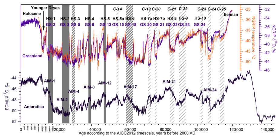
Heinrich Event link:
https://en.wikipedia.org/wiki/Heinrich_event
Did he say “Meltwater”? I hate “meltwater” trolls…
This is my take on the Carolina Bay mystery, which is based upon the work of Michael Davias in the post above.
The Carolina Bays and the Destruction of North America.
https://www.academia.edu/20051868/The_Carolina_Bays_and_the_destruction_of_North_America
The basic primise is that a large meteor or comet struck the Laurentide ice sheet at the beginning of the YD, and spread crushed ‘slush-balls’ all over N America. Thus wiping out all the megafauna of the US, and creating the cool climate that formed the YD ‘black mat’ formations. So the Carolina Bays are secondary impact craters, formed from Laurentide ice.
And these projectiles would have to be slushballs, to leave such shallow impact craters, that only exist in silts and clays. And leave no meteoric debris. The important work of Davias, is that he not only allowed for the coriolis effect in calculating Carolina Bay orientation-trajectories, but also the rotation of the earth during impact. Very astute. And this centers the primary impact on the Great Lakes.
Davias has started looking at 800 kyr ago for this impact, because geologists have been so vociferous in their opposition, because they say the Carolina Bays are at least 150 kyr old. But thermoluminescence dating can only date when a silicate grain was last ‘reset’ and not when it was heaped up into a Bay formation during an impact. I think myself that the dating is wrong, and is not dating the true age of these rather delecate silt and sand formations.
Other evidence includes a find by Prof Firestone (an apt name) of fused tree wood. This sample was not carbonised, but melted on one side. This can only happen at temperatures above 3,500 oc (from memory), which rather precludes a forest fire and indicates a meteor event. And such high temperatures and universal destruction WOULD, of course, wipe out all N American megafauna.
Ralph
More Carolina Bay ‘impact craters’
http://www.scientificpsychic.com/etc/timeline/carolina-bays.jpg
.
I like the multiple overlapping and directional Carolina Bays, in this and other pics. Difficult to explain, other than from aeriial impacts.
R
Ralph – please evcuse my ignorance. These things look directional, for sure, but isn’t it a bit surprising that they are symmetrical about both long and short axes?
>>isn’t it surprising that they are symmetrical about both long and short axes?
Not really, this is what low angle trajectory impacts do – they form ellipses rather than circles. You will see explanations elsewhere that a meteorite will always form a circle, no matter what the trajectory. But this is not true of very low angle impacts.
And it is not true of low-speed impacts – they are much more likely to form ellipses. And remember that the Carolina Bays are very different in shape, depending on their distance from the Great Lakes. The nearby ones are very elliptical, while the more distant ones are more circular. And this is just what we would expect, if their shape was determined by their trajectory and impact angle.
Ralph
ralfellis, I was told by a geologist that impact craters are uniformly round, even at very shallow trajectories for the meteorite. Perhaps these are not impact craters. Not trying to start an argument, but just repeating something I was told a few years ago.
Where was that carbonized wood found? I guess at the putative primary impact site?
>>Where was that carbonized wood found?
Vitrified, not carbonised.
It was in one of the Carolina Bay rims, and so directly linked to the Carolina Bay formations. As you can see, this was a 3,500ºc flash vitrification, as the other side is still composed of unburned wood. This sample was obtained by Prof Firestone, so one presumes it is a genuine find.
http://oi68.tinypic.com/dre2xw.jpg
.
And look at the temperatures required in this phase diagram, to get carbon to liquefy:
Thanks. So, what exactly is assumed to have caused this? If the secondary projectiles consisted of ice, how would they generate/withstand such temperatures?
>>how would they generate/withstand such temperatures?
Hi Michael.
The slush-ball will maintain its integrity in the same manner that the Apollo capsules did, by ablative protection.
The stagnation air temperature of the atmosphere for a Mach-7 projectile at 80,000 ft is about 4,000ºc. (Stagnation temperature is the temperature of the air when brought to relative ‘rest’ by the reentry capsule’) While the stagnation air temperature for a Mach-4 projectile at 20,000 ft is about 2,000ºc. The Space Shuttle initially reentered the upper atmosphere at a staggering Mach-25, before rapidly slowing.
NASA stagnation air temperatures
Track along the Tt 400 line, until reaching Mach 7 and 80,000 ft
https://www.grc.nasa.gov/www/BGH/stagtmp.html
While the stagnation temperature is undoubtedly very hot:
a. Ice has a high latent heat of melting and vaporisation, so it can cool the surface very well.
b. Ice has a low thermal conductivity, so the temperature cannot penetrate a block of ice 500m across very easily. Ice is actually very difficult to melt, with a flame.
So although the surface of the ice-ball would be very hot, just like the Apollo capsule, that would just be a surface temperature. The rest of the ice would remain frozen. Especially when you consider that these slush-balls were anywhere from 50 m to 700 m across.
However. The radiative effect of this reentry slush-ball is determined by the surface temperature, which would be anywhere between 2,000ºc and 4000ºc. So the ground surface below a million of these glowing ice-balls with a surface temperature of 4,000ºc (all in tight formation) would be high – very high. Apparently high enough to vitrify wood, as well as exterminate all the megafauna.
Cheers,
Ralph
(I call them slush-balls, because the Bay formations suggest a softer, more pliable bolide than a single lump of ice.)
.
I don’t think it works like that. Only very few materials would even come close to the very high equilibrium temperatures that you cite. The actual surface temperature is limited by the melting point (or, assuming the liquid phase somehow manages to hang on, the boiling point). That is, after all, the mechanism of “ablative protection”. So whatever gave rise to this piece of vitrified wood, it can’t very well have been the impact of a white-hot slushball.
PS an (unrelated but) interesting example of “reverse” ablative protection happens if you dip your hand into liquid nitrogen. A “glove” of gas instantly forms around your hand, and it gets away unscathed. I’ve done it many times when retrieving some flash-frozen small sample vials from a jar of nitrogen.
>>The actual surface temperature is limited by the melting
>>point (or, assuming the liquid phase somehow manages
>>to hang on, the boiling point).
The high temperature is actually in the shock-wave, not in the material of the reentry vehicle itself. The stagnation temperature is generated in the shock wave, when the air comes to a rapid halt (relative to the space capsule). And so the temperature of the air is very high in that instant – some 4,000ºc high – no matter what the surface temperature of the capsule is. That energy is then radiated to the capsule surface, and also to the atmosphere and the surface of the earth.
R
Ah, o.k. That sounds more plausible. Thanks.
ralfellis
December 19, 2016 at 2:16 pm
Why would you assume the sample is valid? Firestone’s colleague West (an assumed name) has at best a dubious past:
https://psmag.com/comet-theory-comes-crashing-to-earth-c9e9056e29db#.fpueosa94
If that actually is a valid sample of vitreous carbon found where the authors say it was, there is no reason to imagine that it formed in a cosmic impact.
>>Why would you assume the sample is valid?
If you think this artifact was fabricated, then how was it done? How would anyone flash melt (vitrify) carbon, at 4,000ºc, without burning the rest of the sample? What technique and apparatus would you use?
As to Prof Boslough, I have conversed with him, and his eyes are tightly shut – a very non-scientific position. He maintains that the Carolina Bays do not show the morphology of a hypervelocity meteorite impact (he is a high energy impact physicist). I tried to explain that these were probably low-speed impact by crushed ice, but he refused to investigate the effects of low-speed slushball impacts onto silts and sands.
So how will we ever know the morphology of such impacts? For instance – would the wet silts act like a non-Newtonian fluid, and harden under impact? Who knows, because it has not been tried nor tested.
Ralph
http://abob.libs.uga.edu/bobk/cbaybib.html
ralfellis
Looking at the pictures you have posted. Whatever has caused these oval shapes,it looks like its been something that has happened over a period of time. Rather then a sudden impact. Because notice how the clearer oval shapes sit on top of older and more worn down ovals. Rather like the craters on the moon.
Thing is what happens when a process happens happens over time.
“This” not “Thing”
>>notice how the clearer oval shapes sit on top of
>>older and more worn down ovals.
Not necessarily. The larger slush-balls will tend to arrive first, because they are not slowed by the atmosphere, and the smaller ones a little later. So the first Bays to be formed will tend to be the larger ones. However, when a smaller bolide arrives a few seconds later, it will tend to obliterate the larger one. And its splash pattern will tend to cover the rims of the larger one.
This is only my reasonable assessment. If the geological fraternity had taken the Firestone and Davias impact theory more seriously, they might have done some low speed impacts, and generate more detailed information. I did ask a hypervelocity impact group at Scania Labs to run some simulations, but not sure what happened with that.
Ralph
Michael Davias has also done some rudimentary experimentation on low energy, low angle impacts:
http://cintos.org/SaginawManifold/introduction/index.html
These were my sand impact experiments at low velocity and low angle. Very rudimentary, I know, but they demonstrate the general principle.
http://oi67.tinypic.com/2jbs041.jpg
This was the article I wrote a while ago:
The Carolina Bays, and the destruction of North America
https://www.academia.edu/20051868/The_Carolina_Bays_and_the_destruction_of_North_America
Ralph
There seems to be big ones overlapping small ones too.
>>There seems to be big ones overlapping small ones too.
Undoubtedly. This was just a huge splatter, with blobs of all sizes raining down. But smaller blobs will experience greater atmospheric resistance than the larger ones, due to their greater surface-volume ratio.
Look at this great array of Carolina Bays, large and small. Wind formations? Really?
Image courtesy Michael Davias.
R
http://oi67.tinypic.com/72rcdf.jpg
Or how about these.
Image courtesy Michael Davias.
http://tinypic.com/r/2qai7ab/9
Or how about these – mk2
http://oi67.tinypic.com/2qai7ab.jpg
There seems to be big ones overlapping small ones too.
“But smaller blobs will experience greater atmospheric resistance than the larger ones, due to their greater surface-volume ratio.”
But that is my point. You seem to be suggesting that smaller ones get slowed up and arrive later. But there are larger ones overlaying smaller ones.
Those are not impact craters.
>>Those are not impact craters.
Reasoning?
R
“…of fused tree wood. This sample was not carbonised, but melted on one side.”…
Or fossilized tree wood? Excuse me, but I am not quite understanding.
Tip of the hat for this. Such a pleasure to read. The hypothesis may be right or wrong. Seems to make sense to me, but then I am largely ignorant of the multitude of variables involved. No matter what, we are in the presence of intellectual honesty and a search for truth, what science used to be about before it became subsumed underneath the climate change bandwagon. For a good example of what isn’t science, please see front page NYTimes polar bear story today, to which Kip Hansen issued a rejoinder in the comments section. Pure propaganda.
Thanks. I have no idea if this theiry is right or wrong either, but it kinda makes sense in a holistic fashion. And that, to me, passes the occam’s razor test.
Besides, I do so hate the very dismissive attitude of the many geologists I have conversed with. When they treat an idea like dirt on their shoes (as they have done to Davias too), without even considering a reasoned refutation, you sort of get a feeing something is wrong.
They will not even allow Davias or myself to mention this on Wiki. The gatekeeper says Wiki is for peer review papers only. SINCE WHEN? And so all our Wiki additions have all been deleted, over a number of years. So nobody can debate this, because nobody knows about it. And I don’t like that. (There is a book out there by Firestone, which I did not see until after writing my article. It is worth a read. But again, if there is no mention of this book, how can the subject ever be explored and debated?)
Ralph
Thanks for the reference to the book. Looks interesting so I ordered it.
Slightly OT, but I see the owner of Wiki is looking to change how it works.
Thanks for all the links, this is really well thought through. Interesting theory. The lack of ejecta may be explained with the evaporation of the water and the lack of cohesion in the left over sand and mud and the following erosion by water/ wind. I read parts of your theory so you may have covered that. The link to Dr Firestone ‘s material is great.!
>>The lack of ejecta may be explained
The best I could do was a sling, throwing consolidated sand balls onto a dry beach, at a low angle. And it formed ringed ellipses, with a higher ring at the far end than the near end, just like the Bays. The bolide material tended to bounce out of the ellipse, leaving a pristine ring and no deposits. Very rudimentary, I know, but then I don’t have a government department working for me…
R
>>Thanks for the reference to the book.
>>Looks interesting so I ordered it.
Try also Michael Davias’ Cintos site. It was Davias who did the projectile adjustments, to arrive at the Great Lakes site.
http://cintos.org/SaginawManifold/introduction/index.html
Ralph
ralphellis @ 11:07
Sort of confirms my impressions of Wikipedia. As a geologist I find that so very wrong…Keep plugging away…remember Wegener! Do not give up. I don’t know if you’re right or wrong but keep at it! However, it all sounds very plausible to me.
Playing devil’s advocate, is one to assume that graphane, graphene, or nanocrystalline copper are not products of bolide impacts? I only read that these found these components but no nanodiamonds. Nowhere did the paper conclude the other compounds could not be impact products.
BEFORE ANY CONCLUSIONS ARE MADE I THINK THAT A RESPONSE SHOULD BE HEARD FROM DR. RICHARD FIRESTONE https:anthrpology.net/…/more-clovis-comet-debate-and-a-fro…Also there are a great many other pieces of evidence that suggest that Earth did have an encounter approximately 13,000; the 1300 year long Younger Dryas cold interval
Hi Rodney,
Here’s a link relevant work on Research Gate:-
Nanodiamond-Rich Layer Across Three Continents Consistent with Major Cosmic Impact at 12,800 Cal BP
The consensus would also need some evidence that nano diamonds would NOT be produced by this size of an impact if they are missing.
NA,
Something else to consider is that while diamond, lonsdaleite, and copper-bearing quasicrystals have been found in meteorites, they are never abundant. That raises the question of just how likely they are to be recovered from sediments.
The YD left an imprint on the 14C record:
http://www.leif.org/research/INTCAL13-All-Data.png
Much too large to be explained by a change in solar activity
The temperature record from Greenland shows that such very abrupt changes happened a lot during the glaciation:
http://www.leif.org/research/Greenland-Temps-d18O.png
It seems unlikely that they are all due to impacts
Yup. Those are Heinrich Events. They show up in ice-rafted debris from ocean sediment cores.
The YD requires no special explanation.
Most of them do not match Heinrich events:
http://www.leif.org/research/Heinrich-Events.png
lsvalgaard
December 19, 2016 at 12:11 pm
A lot of them do. Those which don’t are also often (if not always) associated with meltwater pulses from sources other than drifting icebergs from glaciers or grounded ice sheets, such as the collapse of floating ice shelves.
Isvalgaard,
In other words, the temperature change we are currently experiencing is not “unprecedented.”
Leif….
If you want to see how unique the YD cooling was, the best record in the CH4 plot, not the d18O plot. You see how dramatic the fall in temperature was. Certainly the signature one would expect from a great cometary impact. The methane plot is the top graph.
Extracted from Lemieux, “Consistent dating for Antarctic and Greenland ice cores”.
http://oi66.tinypic.com/x6d94y.jpg
The 18O method is quite reliable. The main argument against the impact hypothesis is that there are many such abrupt changes during the last glaciation. It is extremely unlikely that those were cased by impacts as there are no ‘smoking guns’ elsewhere for those.
I should have said that CH4 tends to be indicative of temperature, just as d18O is. So the top graph above is a proxy temperature plot. But the signature of CH4 is worldwide, rather than being local (if I remember correctly) and so shows up in the Antarctic record rather better.
The blue plots in the top graph above are Antarctic, while the orange plot is Greenland. You see how they are much more alike, than the d18O plots. They are only together like this because Lemieux has aligned them – they were originally 350 years apart. Lemieux argued, rightly I think, that the dating was out of synch, not the methane record. So he reformulated a new date and chronology for the YD, which is indicated on the graph above. I think this is the best YD date you can get.
Ralph
Ralf,
How is that consistent with an impact? The world got colder, so naturally methane levels fell to their previous low levels during the preceding glacial interval.
The steep drop and steep return to the prior deglaciation level are consistent with a natural climatic variation.
There was no methane spike from the enormous Yucatan impact in shallow water at the Cretaceous-Paleogene boundary, which caused a mass extinction event. That massive impact was probably from an asteroid rather than a comet, but it left a huge crater and evidence of many other effects, so we know it happened, unlike the conjectured YD bolide.
Even if they were not all due to impacts, how can we differentiate between what the impacts are and what isn’t,,,
Impacts leave marks [e/g/ craters]. Where are all those craters?
>>Leif.
>>The 18O method is quite reliable.
Yeah, sure Leif. So why is the YD barely visible in the d18O record, and perfectly clear in the CH4 record? Sometimes, I think you like to argue, just for the sake of it.
.
>>How is that consistent with an impact? The steep
>>drop and steep return to the prior deglaciation level
>>are consistent with a natural climatic variation.
That steep is natural variation? No, that is much steeper than even an interglacial warming, which takes place over about 5 kyrs. It is more like a D-O warming event, which is again catastrophic, in my view, because they are likely caused by conflagration ice-albedo reductions. (And yet D-O cooling periods are not so steep as the warming, nothing like the YD cooling.)
I would like to see another cooling event that steep.
Ralph
why is the YD barely visible in the d18O record
It is VERY visible, if you would care to look:
http://www.leif.org/research/Greenland-Temps-d18O.png
as are about a dozen such events the last 60,000 years.
>>Leif
>>Impacts leave marks [e/g/ craters].
>>Where are all those craters?
The comet/meteorite hit the Laurentide ice sheet covering the Great Lakes region, which was up to 3 km thick at the LGM. So where do you suggest we start looking, to find the impact crater??
Ralph
lsvalgaard
December 19, 2016 at 4:02 pm
“Where are all the craters?” Indeed. Where is the conjectured YD impact crater?
The WAG of a YD impact posits a bolide of “a few kilometers” in diameter, vs. the ten km of the K/T asteroid 66 million years ago. Impacts of that size occur on average every 100 million years. Meteors of just a single km hit only once in every 440,000 years. The odds of one three to five times as big striking less than 13,000 years ago are tiny.
Let alone dozens of them in only 60,000 years.
>>It is VERY visible, if you would care to look.
No it is not, it is jagged and all over the place. Look at Don Easterbrook’s red and blue graph below, where he has managed to find three cooling periods in the YD. Whereas the CH4 temperature record suggests that those fluctuations are merely aberrations. In reality the YD was a simple and rapid reduction in temperature, and a single recovery.
And the D-O events are not the same, as I have already explained. D-O events are a rapid warming, followed by a slower cooling. A response to continent-wide conflagrations changing the NH ice sheet albedo. The YD is quite a different scenario. It is a rapid cooling, a steady cool climate, and then a rapid warming. Altogether different.
As I said before, not all temperature changes are the same. But you dismissed my considered and well-argued assertion, because you seem to think summer and winter are the same thing – merely temperature variations…
http://oi66.tinypic.com/x6d94y.jpg
No it is not, it is jagged and all over the place
That is exactly the point. The large excursions occur “all over the place” showing that impacts are not a plausible cause.
ralfellis
December 19, 2016 at 4:31 pm
There is no evidence of an impact on the ice sheet.
A meteor three to five km in diameter wouldn’t have burst in the air, a la Tunguska. It would have plowed into and probably through the Laurentide Ice Sheet, depending upon where it hit. Its diameter would have been greater than all or most of the ice sheet’s thickness.
Chimp
There is no evidence of an impact on the ice sheet. A meteor three to five km in diameter wouldn’t have burst in the air, a la Tunguska. It would have plowed into and probably through the Laurentide Ice Sheet, depending upon where it hit. Its diameter would have been greater than all or most of the ice sheet’s thickness.
__________________________________
Err – there is no ice sheet any more, so how would you know if there was a crater in it?
As to the size of the crater, well someone needs to crunch some numbers. The energy of a meteor-comet depends on ‘v’ more than ‘m’. So how great was ‘v’ and how big was ‘m’? And As I said at the top of this thread, the circular form of the Great Lakes, which encompass the impact site, may well suggest that the primary impact did indeed stress and fissure the underlying rocks around the impact site (on the ice sheet above).
R
>>Leif
>>Impacts leave marks [e/g/ craters].
>>Where are all those craters?
If there was no impact, then why has vitrified carbon been found in the Carolina Bays? Where did that come from? Clovis man making lasers?
R
Ralph,
There is no evidence of an impact anywhere, let alone over the Great Lakes, whose formation is well understood, supported by all available evidence.
As noted elsewhere, the alleged sample of supposedly vitreous carbon is not valid evidence of such an outlandish conjecture. Remarkable claims need remarkable evidence. You have none at all, let alone remarkable.
Since most do not match Heinrich events, an alternative hypothesis is that those Heinrich events that do match don’t cause the temperature change but are something that happens when there are rapid changes in temperature for some other reason such as volcanic or natural variation in ocean currents.
I could believe that.
If not solar activity, what did cause the change in 14C levels?
Michael,
There are two explanations.
One, based upon 14C samples from Polish lakes, suggests that the excursion in radiocarbon flux was less than previously estimated, so that its cause could be solar.
http://www.nature.com/nature/journal/v403/n6772/full/403877a0.html
The other is that the apparently high 14C readings resulted from “a reduced exchange with the deep-ocean reservoir, caused by a drastic weakening of the deep-ocean ventilation”.
Your link is to a 16 year old paper. My graph is based on the INTCAL13 record, which is the most recent 14C record [from 2013].
It is well-known that climate has an influence on the 14C level by partly controlling the Carbon Cycle in the atmosphere.
I also favor a terrestrial explanation. I know the paper is from 2000, but the authors did find lower 14C at their sites. Subsequent observations have confirmed higher estimates, but I wouldn’t call the solar hypothesis falsified.
High cosmic ray levels [and 14C] are caused by low solar activity. During the Maunder minimum solar activity was about as low as it can go. The 14C excursion from that was a lot smaller than the YD [and many other] event, so it seems very unlikely that those events are solar based. “Falsified” is a strong word, and so is its negation. All we can say is that the evidence is against a solar cause.
The INTCAL13 record:
https://journals.uair.arizona.edu/index.php/radiocarbon/article/view/16947
“The IntCal09 and Marine09 radiocarbon calibration curves have been revised utilizing newly available and updated data sets from 14C measurements on tree rings, plant macrofossils, speleothems, corals, and foraminifera. The calibration curves were derived from the data using the random walk model (RWM) used to generate IntCal09 and Marine09, which has been revised to account for additional uncertainties and error structures. The new curves were ratified at the 21st International Radiocarbon conference in July 2012 and are available as Supplemental Material at http://www.radiocarbon.org. The database can be accessed at http://intcal.qub.ac.uk/intcal13/.”
Thanks for the data.
It was solar activity!!
“Prior to the Younger Dryas, the climate had gradually warmed from glacial conditions to near modern temperatures” ?w=623&h=394
I think not. The Younger Dryas was preceded by several other abrupt warming and cooling phases which marked the end of the last Ice Age. The Younger Dryas was only one of such. The climate warmed very rapidly after the YD and stabilised as the Holocene interglacial. This is why the impact theory of the Younger Dryas has never really convinced me; it does not explain the the other very abrupt climate changes which happened (in Greenland at least) during the last termination.
however, we show that they misidentified polycrystalline aggregates of graphene and graphane as lonsdaleite,”
======
nooooooooooo……LOL
Latitude,
And “LOL” contributes what to the discussion?
I wasn’t contributing anything to the conversation Clyde… on purpose
Shape of the Great Lakes. The Lake Superior basin is part of the mid-continent rift, which developed between 1.3 and 1.1 billion years ago. The rift extends from Kansas up to Lake Superior and curves sharply back to Ohio. The rift valley was filled with volcanic and sedimentary rocks that have eroded away in the exposed portion of the MCR (the rest is covered in younger rocks) leaving Lake Superior (a very deep lake, unlike the other Great Lakes)..
The circular shape defined by Lakes Huron and Michigan is a result of erosion around the edges of the circular Michigan Basin, which is filled with sedimentary rocks from Ordovician to Carboniferous in age.
Take away those features that are the result of much older geological features, and there’s no pattern that you could attribute to a relatively recent impact.
No links but you can google “mid-continent rift” and “Michigan basin” and learn some good stuff about geology.
No reflection on these Carolina Bays. There could well have been an impact somewhere in the Great Lakes region, but it would be nowhere near the size of the Superior or Michigan basins. I think I might start looking for a candidate for an impact structure. It’s an interesting idea.
Good summary
Yes, and a rift segment is not a crater wall. All it takes is closer inspection and a step back from drawing big circles and centroids.
One Smart Rock there! Yes, the Lake Michigan and Lake Huron basins are perfectly mapped to the surface expression of the older, softer shales around the perimeter of the Michigan Basin. The Lower Peninsula’s bedrock at the center of the Michigan Basin is far more resistive to glacial erosion, being composed of Mississippian, Pennsylvanian and Jurassic sedimentary deposits with more carbonate cements. Looking at the topography of Lake Huron’s floor, one can see the ice flow diverted clockwise around the resistant core of the basin, and to the west, the flow was controlled counterclockwise around the core, thus carving out Lake Michigan. There is one flagrant exception: according the glacial experts the “Saginaw Lobe” turned 90º out of the Huron glacial stream and carved upwards through the resistive core to cut Saginaw bay and its environs from competent sandstones and limestones. This anomaly drew my attention, and has been the focus of my “lost impact site” search. Science has another weird “lost impact crater”, one that is fully validated by the extensive (1/3 of globe) distribution of the Australasian Tektite Strewn Field. That event happened “only yesterday” at the Mid-Pliecstocene Transition, and despite being considered the largest cosmic impact since the Chesapeake event, the requisite impact structure has not been located. Tektite chemistry demands that the impact ejecta was excised from Jurassic continental sedimentary deposits, so the impact can’t be in the deep oceans. So we have two enigmas, both missing craters in the last million years….
Straining gnats, and swallowing camels: debating obscure oblique impacts and their consequences, and ignoring the LACK of oblique or grazing impacts on any observable body in space. They, apparently, never ‘wing’ one another; just hit dead center, whatever their mass and velocity.
The YD is not really a feature in its own right, it is the gap between the Bolling Allerod, the last of the DA spike events (“micro-interglacials”) to take place during the last glacial interval, and the Holocene inception.
http://www.nature.com/nature/journal/v379/n6562/abs/379243a0.html
The Bolling-Allerod itself was likely caused by a large meltwater pulse from Antarctica around 14,600 years ago – Antarctica had already been warming slowly for several thousand years at this point.
http://science.sciencemag.org/content/299/5613/1709
The explanation of the BA and YD from oceanographic processes accompanying the ending of the last glacial period is sufficient and complete; no bolide or other “deus ex machina” is required.
YOU ARE CORRECT ISVALGAARD, EVEN THE PROPONENTS OF THE NORTH ATLANTIC AS SHUTTING DOWN AGREE WITH YOU ON THE CARBON 14 ISSUE. FROM MY RESEARCH, MORE CORRECTLY FACT GATHERING FOR MY NEXT BOOK, THE MOST PLAUSIBLE (ALREADY WROTE “SUDDEN COLD” ON THE YOUNGER DRYAS). AND ACCORDING TO SEVERAL OCEANOGRAPHERS THE THC OR AMOC OR WHATEVER YOU WISH TO CALL IT, IS A MYTH.
.
YOU ARE CORRECT ISVALGAARD, EVEN THE PROPONENTS OF THE NORTH ATLANTIC AS SHUTTING DOWN AGREE WITH YOU ON THE CARBON 14 ISSUE. FROM MY RESEARCH, MORE CORRECTLY FACT GATHERING FOR MY NEXT BOOK, THE MOST PLAUSIBLE CAUSE IS AN ENCOUNTER WITH A COMET. (I HAVE ALREADY WRITTEN A BOOK I CALLED “SUDDEN COLD” ; THIS ON THE YOUNGER DRYAS,. AND ON A RELATED NOTE, ACCORDING TO SEVERAL OCEANOGRAPHERS THE THC OR AMOC OR WHATEVER YOU WISH TO CALL IT, IS A MYTH.
.
Mysteryseeker,
Do you still own one of those old teletype machines?
I sure hope he won’t do this in the book he speaks of.
@mysteryseeker
Mixed UC and LC please. Many people think that all-caps is shouting. I just don’t want to read it.
Ian M
At least it’s not in leftward script. That would be more mysterious yet.
Sorry guys,very funny, it is just an old habit I have. Note I have corrected my mistake. I was not shouting,but perhaps I should be as some of the comments left here are truly way off the mark.
I saw this:
http://cosmictusk.com/comet-research-group-responds-to-robert-schoch/
Paul,
That’s not a response to the new papers cited in this post.
I didn’t say it was.
Does this mean Schoch has given up claiming that the Sphinx was carved by Atlanteans?
Diamond, copper, graphene? Bring in the top refraction microscopists to make sense of it all.
The paper says:
here is no evidence for a spike in the nanodiamond concentration at the onset of the Younger Dryas to suggest that an impact event occurred.
______________________
See my posts on the Younger Dryas impact theory above.
It is worth noting that if a comet impacted the Laurentide ice sheet 12,000 years ago, there would have been little or no carbon in this impact, to create any nano-diamonds.
Ergo, the lack of nano-diamonds is not evidence that there was no YD impact.
Ralph
There is no evidence for such an impact, so why imagine there was one?
>>There is no evidence for such an impact,
Read the posts on the Carolina Bays.
There is plenty of evidence.
R
The Carolina Bays offer no evidence of an impact and bear no relation to the formation of the Great Lakes.
All the evidence shows that the bays formed through terrestrial geologic processes. There is no valid evidence in favor of impacts.
Chimp, it is unfortunate that the Carolina bay formations continue to be entangled with the Younger Dryas Impact Boundary theory. As you say, hogwash, the Carolina bays are clearly proven by C14 and OSL to be older than 120ka. My position is that until isotopic Be dating is applied, both the C14 and OSL results only show “must be older than” dates for their formation. Whatever their genesis, it will not be solved by dwelling on the gigantic non-starter that the YDB timing bring to the discussion. While I always appreciate an opportunity to share my cintos.org work with good thinkers, trying to dismiss the good science done on dating the CBs as older than 120ka drives the discussion into non-science nonsense. I firmly believe there was no “impact” at the YDB – While I presented at the 2009 AGU special session on the topic, I immediately recognized the date had been confidently falsified. The last known terrestrial impact of significant note was the one that created the 60 Billion tons of Australasian tektites and micro-tektites, spread across 1/3 of the globe from Antarctica to Madagascar to China ~ 780Ka. The site of that impact has not been found despite 60 years of extensive searches. That discussion has slowly trailed off because the consensus search site – within the strewn field itself – has failed to yield a solution and it is no longer fun for serious scientists to discuss (see Kuhn).
The pictures suggest whatever caused these oval shapes was a process that happened over a period of time, rather then a sudden impact.
Maybe everything that sparkles isn’t diamond….It might just be space bling 🙂
There has never been a case for an impact causing these events, unless anybody thought they had occurred so rarely, maybe could they have been missed? Frequent significant changes even larger than shown below, have occurred so often it would be very foolish to think impacts would occur frequent enough to just be responsible for even just a few of them.
http://i772.photobucket.com/albums/yy8/SciMattG/younger_dryas_zpst01vrmwh.jpg
This is a graph I created and published that illustrates my comments below.
>>This is a graph I created and published
But if you use the CH4 temperature record, there is no Older Dryas or Inter Alleroid. There is just a catastrophic Younger Dryas cooling.
http://oi66.tinypic.com/x6d94y.jpg
The CH4 plots on the top graph are from Antarctica (blue) and Greenland (orange), demonstrating good hemispheric consistency and agreement. The ice-core CH4 readings are obviously reliable.
Extracted from Lemieux, “Consistent dating for Antarctic and Greenland ice cores”.
R
I thought you did, hope you don’t mind showing it here.
Hide from me this lonsdaelite which I shall not see. 😉 all your climate changes belong to co2, according to the ministry of truth.
The Younger Dryas is only one of many climate reversals during the late Pleistocene. As I have posted here several times earlier, a meteor or comet impact is a single event whereas there were many late glacial warm/cool phases. During the late Pleistocene 15,000 to 11,500 years ago, there were three cooling periods,(the YD, Older Dryas, and Oldest Dryas) and two warm periods (Allerod, and Bolling). For details, see ‘Late Pleistocene Abrupt Climate Changes’ (pages 141-143 in “Evidence-based Climate Science” by Elsevier).
Also, the YD began with an incredibly abrupt cooling (~20 F/century), lasted for ~1000 years, then warmed up abruptly (~20F / century). The effects of a meteor or comet can’t last for 1000 years, then warm so abruptly. Whatever caused the YD was not a single event.
Could there have been some sort of solar obstruction between the Earth and Sun to cause such a rapid change over a long term? Orbiting cloud of debris/ice etc.?
There is no such thing as a “climate reversal” there is however various climes that vary overtime, even on a planetary scale.
There are document impacts that have occurred on earth.
There is no evidence that links an Impact large enough to cause a planetary scale glaciation, equally, that same thing can be argued for an interglacial.
Can glaciation happen without an impact?
Did such a hypothetical impact, cause such a catastrophe through a planetary scale glaciation and slowly kill off species who were not adaptable?
Where are the bodies?
“The effects of a meteor or comet can’t last for 1000 years”
Meteor’s burn up in the atmosphere. Impacts come from Comets and asteroids.
ralfellis, aren’t there more recent Impacts visible on earth that swamp those you have shown as evidence above in comparison? what did they cause? A singularity?
Don’t get me started lol 😀
Hi Don: If you believe in the thesis as laid out by Dr. William Napier and other such scientists including Dr. Duncan Steel, that the type of comet encounter were “comet showers” then the theory is plausible. Please note that there was a warming to some extent part way into the Younger Dryas, This was then followed by a return to cold. before it once again warmed up at the start of the Holocene.
It’s more than that–take a look at my graph in MattG above.
Hi again Don: yes i see the level of detail you show in your graph. Your graph may even reinforce the idea as Dr. William Napier suggests, that the Earth was bombarded my “comet showers that could extend over a considerable length of time. They are not constant and after several years they stop, but begin again as we again pass through tail of the comet once again. your graph indicates to me that overall the Younger Dryas was colder, (note that even the upward oxygen isotope spikes fall below the deviations from both the Allerod/Bolling and Holocene intervals. Did you actually interpret the ice core data yourself, because i have never seen the level of detail you present here. Excellent!
>>The Younger Dryas is only one of many climate
>>reversals during the late Pleistocene.
But the Dansgaard-Oeshger events (D-O) were warming events associated with conflagration products, followed by a slower cooling period. The YD is clearly a catastrophic cooling, not associated with conflagration products (and a rapid recovery). They are demonstrably different events.
http://www.nature.com/ngeo/journal/v8/n9/images/ngeo2495-f2.jpg
Sorry, the lower purple plot represents the conflagration products, linked with D-O warming periods.
See: Fischer. ‘Millennial changes in North American wildfire and soil activity over the last glacial cycle’
R
The Great Lakes have no relationship to impact craters–they were carved out by lobes of the late Pleistocene Laurentide ice sheet, as shown by concentric glacial moraines around their margins.
>>The Great Lakes were carved out by lobes of the
>>late Pleistocene Laurentide ice sheet.
Ice sheet lobes that were closely following the deep fissures, created by the impact on the ice sheet above…
R
The moraines were formed by Laurentide Ice Sheet during its maximum advance in the Wisconsin glaciation. Proglacial lakes formed behind them during the retreat of the LIS. No non-existent fissures need apply: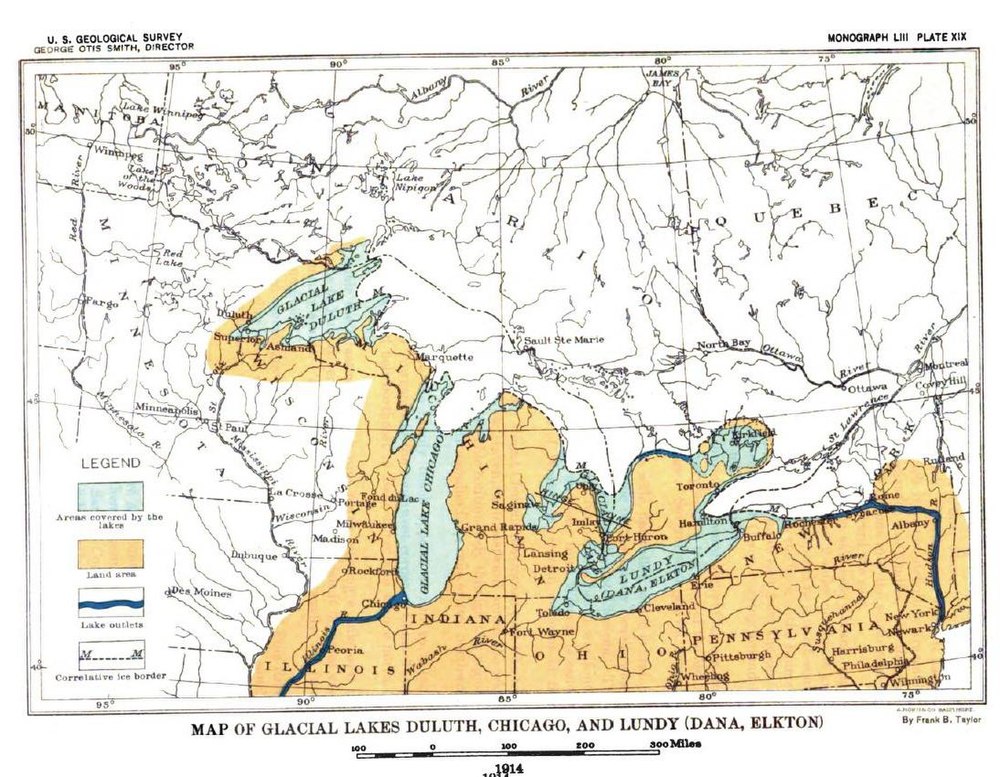
If you want to see what an Earth-skimming meteor looks like, the 1972 fireball is probably the best example. This meteor pops out of a cloud, which places it at about 5,000 ft altitude, from my large aviation experience. Just a whisker lower, and it would have created a nice graze and butterfly impact crater, and still had enough energy to skip back out into space.
Fast forward to 0:30 seconds
>>Don
>>The Great Lakes have no relationship to impact craters.
That may be so. But there does appear to have been an impact in that very location, as triangulated from the orientations of the 1/2 million Carolina Bay formations. And this is something that has been ignored, rather than considered and investigated. And that to me is bad science. If the Laurentide impact theory is to be discounted, there should be a valid reason for its dismissal.
The Carolina Bays and the Destruction of North America.
https://www.academia.edu/20051868/The_Carolina_Bays_and_the_destruction_of_North_America
BTW. As Michael Davias said, the primary impact in the Great Lakes region is likely to have been at a low-angle. This would result in a shallow ‘butterfly impact’ crater on the ice sheet (and underlying rock formations(?)), and it is possible that much of the original bolide may have skipped back out into space.
R
If the Laurentide impact theory is to be discounted, there should be a valid reason for its dismissal.
It works the other way: If the Laurentide impact theory is to be accepted, there should be a valid reason for the acceptance. And there really isn’t any.
The valid reason for its dismissal is that it has not a shred of valid evidence in its favor.
The Carolina Bays are oriented in line with the prevailing winds during the Wisconsin glaciation, as shown by every other possible source of evidence and, yes, even models of atmospheric circulation around the ice sheets based upon that evidence. Their origin is tens of thousands of years before the YD and even most of their modifications precede it.
The impact conjecture is not science. Whatever predictions it makes are easily shown false and have been done over and over again for at least a decade. Much longer if you count the original suggestion in the 1950s that the bays might be from impacts.
At this point, it’s science fiction, nay fantasy, which has become an industry for its few diehard advocates who refuse to accept objective reality either out of pure faith, stubbornness or career interest. Kennet had a good reputation until he hitched himself to this falling star. The others, not so much. To say the least.
>>Leif
>>If the Laurentide impact theory is to be accepted
>>There should be a valid reason for the acceptance.
>>And there really isn’t any.
So you turn a blind eye to the evidence presented here, and in the various linked websites and articles, and say “I see no evidence”. What is your middle name – Leif Nelson Svalgaard?
I ask you again. If there was no impact scenario, how did samples of vitrified carbon (tree wood) end up in the Carolina Bays? Clovis man’s laser experimentation?
R
If there was no impact scenario, how did samples of vitrified carbon (tree wood) end up in the Carolina Bays
There is no evidence that that wood was due to an impact on the ice. Not many trees up there…
And some claimed ‘evidence’ does not hold water and deserves to be ignored. Perhaps you also believe in Velikovsky? Or do you turn a blind eye to his ‘evidence’?
My science is likely a bit antiquated, perhaps, on the events concerning the outflow from Lake Agassiz, but having been born on the floor of this lake it was natural to have been exposed to research work and on scientific tours of the lake features. The various raised beaches and shifted sandy deltas of rivers record the drawdown
and shrinking.
My own discoveries related to this were accidental in the course doing groundwater hydrology in SW Manitoba and mapping Precambrian geology in the middle – north part. In the first case, I discovered a tributary of the ancient Missouri River at a well depth of about 300′. The tan quartz gravel contained petrified wood and opalized wood that had earlier been found in in a borehole in south central Saskatchewan. Apparently the river made an unexpected sharp bend eastward into Manitoba. This was back when the old Missouri drained north to Hudson’s Bay in the previous interglacial. The headwaters of the river was subsequently captured by the present Missouri and flow went to the Mississippi while it’s northern part was buried in glacial lake clays.
I believe a large volume of Agassiz went down the Mississippi while the northern ice dam was in place. Mapping Precambrian for the Geological Survey of Manitoba in 1961, I came upon a shore strand line that had not been mapped previously. It was in the middle of a nice jackpine ‘parkland’ and there in the middle of forest was a magnificent barchan sand dune that looked like it belonged in Saudi Arabia – crescent shaped with fairly sharp ridge about 20′ or so high showing that the prevailing wind was from the east. I believe this strand line to have been the last stage of the lake before it rushed out into Hudson Bay. I’m not convinced the lake sent much water east to the St Lawrence.
Oh and Don Easterbrook, Lake Superior ‘s deeps are about 200m below sea level so I don’t think that would support your idea of glacial carving. I have to like ralfelis’ s impact theory.
Gary,
You missed Don’s explanation about the rift zone, which accounts for the depth of Superior. This is firmly established. The shallower lakes were gouged out by the glaciers, but over Superior they just removed the overburden and exposed the preexisting crack in the earth. The rifting almost tore North America apart, as is happening now in the Rift Valley in Africa and as happened between Africa and North America when Pangaea started splitting up at the Triassic/Jurassic boundary.
Some reading on the rift zone:
http://www.lakesuperior.com/the-lake/natural-world/243-lake-superior-basin-fiery-beginning/
At the time of glaciation, sea level was about 120 m below what it is now, leaving only about 80 m to be accounted for. The fjords of Norway are deeper than that by far.
From the article comment,
This is incorrect and based exclusively on Greenland ice cores which shows the dangers of depending on a single regional proxy.
Neither interglacial conditions had been reached prior to the Younger Dryas, nor there was a return to glacial conditions.
While on the warming towards interglacial conditions there was a cold relapse, but the Younger Dryas was significantly warmer than the glacial maximum of a few thousand years earlier. This is indicated by nearly every proxy record in the World, showing that there is problem with Greenland ice cores at this time.
That the Younger Dryas was a return to glacial conditions is a popular myth that refuses to die.
Let’s see for example sea levels, a quite good indicator of global temperatures.
http://i.imgur.com/Z0j6Uok.png
From: Lambeck, Kurt, et al. “Sea level and global ice volumes from the Last Glacial Maximum to the Holocene.” Proceedings of the National Academy of Sciences 111.43 (2014): 15296-15303.
YD is barely noticeable in sea levels. Clearly not a return to glacial conditions as there was no decrease in sea levels.
Javier
You are falling into the trap Shakun fell into bu ignoring the bipolar seesaw. Reciprocity between the hemispheres was quite prominent during the whole glacial termination. Antarctica first started warming ~20kya. Then 14.6 kya there was the abrupt NH warming of the Bolling-Allerod. While this happened the SH oceans reverted to cooling – this is the well-known “Antarctic Reversal”. Then came the YD where the B-A warming was abruptly reversed. However, following the bipolar seesaw, the SH oceans switched back to warming during the YD.
There is more ocean water in the SH than the NH. That is why CO2 that was outgassing from the warming southern oceans, continued to increase during the NH cool interval of the YD.
Greenland is a correct and accurate isotope record of NH warming and cooling related to the switching on and off of the AMOC (caused by its nonlinear instability resulting from the salinity-downwelling positive feedback). Greenland cores agree in this respect with other oceanic sediment isotope records. However they don’t agree with the army of very poor biological proxies like pollen and midges that Shakun uses. Some of these scarcely resolve the Holocene at all. Shakun uses such proxies to smear the Holocene into a smooth blob and iron out the BA and YD entirely, all in aid of his ulterior and only purpose of fudging a story of CO2 causation of glacial termination.
Warming southern oceans were also the reason that sea level rise – related to average global ocean temperatures – continued during the NH cold snap of the YD.
Shakun didn’t fall into any trap. He committed scientific fraud. He hid that the variability of his data invalidated the main conclusion of his article.
And I am not falling into any trap nor ignoring the bipolar see-saw. Quite the contrary I was talking about it when I said:
“The temperature difference between Antarctica and Greenland during Heinrich events indicates they are oceanic coupled.”
You are the one that is confusing that we are talking about the effect of the Younger Dryas in the World, not in a certain area of the Northern Hemisphere. The global ocean situation is a better representation than any of the poles, as it is integrative. therefore its use is much more accurate than any of the ice core proxies.
And you are the one that apparently ignores the problems that many of Greenland cores display, that include altitude adjustment problems, as Bo Vinther showed with the Agassiz and Renland ice cores. Buizert et al., 2014 have shown with four different reconstructions that contrary to the traditional δ18O interpretation, the Younger Dryas period was 4.5±2°C warmer than the Oldest Dryas.
Buizert, Christo, et al. “Greenland temperature response to climate forcing during the last deglaciation.” Science 345.6201 (2014): 1177-1180.
http://ir.library.oregonstate.edu/xmlui/bitstream/handle/1957/54628/BuizertChristoCEOASGreenlandTemperatureResponse.pdf
And on top of that we have confirmation from China loess deposits and speleothems
http://i.imgur.com/KgGJB1i.gif
There is a problem with Greenland records. When corrected they agree with other proxies in that YD was warmer than OD, and although it supposed a serious cooling in the Northern Hemisphere, it was not a return to glacial conditions, and globally it had little impact on the deglaciation, as sea levels clearly show,
Myth busted.
Javier
I worded my reply badly – what I mainly meant was that your sea level figure implies the YD is a non-entity, whole the reciprocal SH temperature trend accounts for this impression. However in no way did I suggest that the YD represented a full return to glacial maximum, an impossibility in the face of ongoing Antarctic warming.
Also you are right about Shakun, his conjuring trick with proxies is indeed dishonest. Your wording was better than mine in that respect.
The China speleothem figure you show is an important part of the picture regarding the YD.
No, it’s not based solely on the Greenland isotope data. It was first discovered from pollen changes in Europe and has since been confirmed by advance of glaciers all over the world and from many other proxies.
Younger Drys is real. What is not real is that it constituted a return to glacial conditions. It was simply a cold period within a warming trend, and it was warmer than the prior Older Dryas. That it was centered in the North Atlantic region is one more indication that it was analog to a Heinrich event.
Yes, this is true. And although the records from New Zealand and Antarctica show a mixed single, I think that in the case of New Zealand, a reliance upon primarily glacial studies could be the problem, as glaciers are known to respond in various ways to different climates. Further to this, they also may be responding to internal dynamics within the glaciers themselves. And from Antarctica, the Taylor Dome ice core is in a region of higher snowfall,and here the climate response within the ice shows a cooling, just like most of the rest of the world. Whereas, other than Taylor Dome, the other Antarctic cores are of low to very low resolution (low snowfall rate), so they may not be depicting relatively short-term climate changes like the Younger Dryas at all..
A long time ago the YD was also confirmed by fossilised beetles that had lived in England. Can’t remember the scientist that studied them and he found Arctic beetles in southern England around this time by dating the soil/rock layers.
The Younger Dryas appears to be part of a cycle of cooling periods at about 6000-7000 years apart, called Heinrich events. The YD is called H0 by some authors to indicate that it is more recent than the H1 Heinrich event.
http://i.imgur.com/oumF89c.png
From: Bond, Gerard C., and Rusty Lotti. “Iceberg discharges into the North Atlantic on millennial time scales during the last glaciation.” Science 267.5200 (1995): 1005.
Heinrich events are identified by detrital deposition in the North Atlantic. They are best seen in detrital carbonate, but also basaltic glass, and Hematite stained glass. They are clearly different from Dansgaard-Oeschger events, but appear to fit in their distribution.
Heinrich events are characterized by a long period of cooling in the Northern Hemisphere and warming in Antarctica, accompanied by an increase in CO2. They end in a Dansgaard-Oeschger event type of abrupt warming in the Northern Hemisphere. The Younger Dryas is quite similar except for being shorter than most Heinrich events and not as cold.
The temperature difference between Antarctica and Greenland during Heinrich events indicates they are oceanic coupled, and oceanic currents must play a very important role in Heinrich events. It is inconceivable that they are caused by meteorite impacts. it cannot be discarded that solar variability plays an important role, but at the moment we don’t have good evidence for that.
Heinrich events are also clearly identified in the salt levels variability in Greenland ice cores. Paul Mayewski has studied this feature by obtaining a derivative of multiple salts that he calls Polar Circulation Index (PCI) He defends that PCI presents a cyclical signal of 6100 years that he identifies with the Heinrich cycle.
In this figure it is the purple cyclicity and some of the peaks correspond to Heinrich events, including YD:
http://climatechange.umaine.edu/Research/MaineClimate/images/PCI.jpg
Source: http://climatechange.umaine.edu/Research/MaineClimate/SysPerspective.html
“Prior to the Younger Dryas, the climate had gradually warmed from glacial conditions to near modern temperatures, and the massive ice sheets in North America were in full.”
Did I read that right? I was under the impression that pre Younger Dryas temperatures (coming out of the ice age) was greater than modern day temperatures.
You might be thinking of insolation rather than temperature.
Actually pre-Younger Dryas temperatures (14,000-13,000 yr BP) were intermediate between Glacial Maximum conditions (coldest, 18,000 yr BP) and Holocene Climatic Optimum, or Hypsithermal (warmest, 7,800 yr BP). Most probably colder than the Little Ice Age but a great improvement from the Glacial Maximum.
15,000 years ago, the Ice Age was in full swing. The about 14,500 years ago, temperatures abrupt soared to slightly below present-day temps, then just as abruptly plummeted back to full glacial conditions (the YD) for about 1000 years, then soared once again to the early Holocene maximum. These abrupt changes in temp, both warming and cooling, occurred in about a century.
No they did not. They did not return back to full glacial conditions. Not even in Greenland. Much less in the rest of the world. The Younger Dryas was 4.5 ± 2 °C warmer in Greenland than the Older Dryas.
Buizert, Christo, et al. “Greenland temperature response to climate forcing during the last deglaciation.” Science 345.6201 (2014): 1177-1180.
http://ir.library.oregonstate.edu/xmlui/bitstream/handle/1957/54628/BuizertChristoCEOASGreenlandTemperatureResponse.pdf
That during Younger Dryas temperatures returned to full glacial conditions is a myth not supported by evidence.
And to think that 14,500 years ago temperatures in the World where slightly below present-day is just as risible. Great parts of the Northern Hemisphere were covered in huge ice sheets at that time. You are making huge mistakes in your interpretation of pre-Holocene climate. The biggest of all is to rely on problematic Greenland ice cores as if they were the bible for global climate.
>> What sort of impact pressures and shock waves would be transmitted through 3 km of ice, onto the rock strata below?
Sounds like a possible college project. Maybe cross-discipline (Computer Science, Math, Physics (Material Sciences, Geology)). Fun!
Fascinating, educations are to be had here. As a historical note Armstrong Price, an early 20th century field geologist working with early mapping suggested a “ Continental Wheelround of dune-making and wave-forming winds of glacial times.” He included Carolina Bays in a clockwise system for the northern hemisphere, anti- for the southern. He was a resident and mainly a student of the windy, relatively dry south Texas region and discounted meteorite scars, partly based on magnetometer surveys and other work. He had a broad area of interest, well respected in all scientific areas he intersected. Unfortunately, his archives apparently did not survive but there are a few left that knew him. I suspect all here would find this worth reading and maybe someone here knows about its history.
Price, W. A. 1958. Sedimentology and Quaternary geomorphology of South Texas; Supplementary to Field Trip Manual “Sedimentology of South Texas,” Corpus Christi Geological Society Field Trip. pp. 41-75.
A great geologist with a long and productive career in academia, industry and government work. Price lived almost a century, 1889-1987.
He spent part of his youth and graduated from college in NC, with a PhD from Johns Hopkins.
IMO, he solved the supposed “mystery” of the Carolina bays and similar formations in the middle of the last century.
An underappreciated far-seer who in my book ranks right up there with his contemporary prophets without honor the great (and even longer-lived) Harlan Bretz (1882 to 1981), who survived to enjoy vindication, and Alfred Wegener (1880 to 1930), whose life was sadly cut short by his exertions on behalf of science.
That is high praise, right up there with Harlan Bretz. Although I do not know that much about the Carolina Bays, and even though I believe in multiple small impacts as cause for the Younger Dryas, I am inclined to believe Dr. Prices’s assessment
H. D. Hoese:
Thanks for the tip.
Here is the link Price, W. A. 1958
Just curious, does a comet slamming into a 2 mile thick ice sheet make nano-diamonds? I was under the impression the comet had to hit rock or sand or dirt to make them.
“however, approximately 12,900 years ago, temperatures rapidly plummeted and returned to glacial conditions for about a 1200 year long period. Also about this time, the mammoths and mastodons became extinct in North America.”
It’s obvious, isn’t it? Those were big animals, and they breathed out a lot of CO2, and emitted a lot of methane as well. When they became extinct, the level of greenhouse gases in the atmosphere dropped, and the Earth cooled down.
Please send money for further research.
And think of all the CO2 taken up by the plants not eaten by the then vanished megafauna!
Too bad that the magic words “climate change” may have lost their magic under the Trump Administration.
You coulda been a contendah in the Michael Mann Memorial Trough Feeding Frenzy.
Not that the YD actually was responsible for the Pleistocene megafaunal extinctions, of course. The mighty beasts had survived many such climate flips.
The difference with the YD was the advent of human hunters in North America. On isolated Caribbean islands, the megafauna survived the YD, only to go extinct when the first boat people arrived.
The Bering Sea is not in the Caribbean, but still of interest
http://www.gi.alaska.edu/alaska-science-forum/tight-evidence-what-killed-st-paul-mammoths
The official “NZ Willy theory of the Younger Dryas” is that the Arctic Ocean was solid ice in the ice age up to then, and the world was warming but the Arctic still frozen solid, but then an under-ice channel finally opened up which allowed a high-volume ocean stream to run from the Atlantic to the Pacific under the Arctic ice cap. This huge cold water influx dropped the global ocean temperature by 5C average, so plunging the planet back to frigid conditions, i.e., the Younger Dryas. It wasn’t until the Arctic Ocean melted out completely that global warming could continue. So how long does it take to melt out a frozen-solid Arctic Ocean? 1200 years sounds about right.
We still don’t account for those things that we don’t know about. Discussions above discuss rapid temperature changes, up and down, over long term time scales. There is much in space out there and we certainly could have encountered a mass that obstructed the energy from the Sun, think of a moving Nebula of matter over a long term exposure, that made a difference that we have no accounting of on earth aside from what we think happened. Just sayin, we only know what we know, and don’t know what we don’t. So far, nobody has that explaination for the changes we know of…….. so there ya have it! 😛
“Paradoxically it was Daulton’s experience finding nanodiamonds in stardust that prepared him not to find them in sediments.”
v’ !
Chimp restates the idea that it took humans to wipe out the megafauna in North America and I am absolutely not saying he is wrong, but I honestly struggle with this frequently used explanation. It isn’t just that the range of the megafauna is so much greater than mammoths or mastodons, it’s all the dozens of other forms that go out so dramatically. You can understand the giant sloths disappearing, probably specially targeted by early green hominids worried about their methane emissions and general ugliness, but all the other species: dire wolves, elks, etc. And the early horse in a continent absolutely suited to their needs.
It just seems a very long stretch to believe that the vanishingly small numbers of early humans in North America went on such a spectacular frenzy of animal killing that despite lacking sophisticated (modern ) weapon they sent everything extinct in short order when by comparison modern Americans with repeating rifles, modern horses, railroad backup and huge financial incentives still just failed to kill all the bison. Why would hunter gatherers kill everything when they had no need to do so? It goes against the way early people behave anyway.
Of course, climate change would have helped things along, but it is the range and relative suddenness of the mega fauna extinction that seems so striking. Having read the contributions I’m less inclined to believe this particular impact thesis but in general impacts do provide a dramatic explanation for sudden extinctions and we probably underestimate the number of these events. I understand why,, but I do think there is a dislike amongst many earth scientists for impacts which predisposes rejection. I do wonder though whether we are seeing “alignments” in the bays where none might really exist. Make a series of random dots on a bit of paper and you can quickly find “significant” alignments.
You forget the amount of time at their disposal. They had thousands of years to do it and were very focused on animal hunting as they were no farmers.
But you are right in that it is a complex issue and some were no doubt exterminated by humans, as the coincidence in human arrival to the Americas and Oceania is just too good, while others were no doubt finished by other factors. As usual a mixture of natural and anthropogenic causes is necessary to explain the megafaunal extinction phenomenon, as it is to explain climate change.
For those of you asking “where is the crater”:
This link is a re-post from the last time this subject came up here. For those who haven’t seen it yet….
The author does a very good job of fleshing out his theory in regards to where and how the comet impacted. Comets impact differently than say an iron-nickle meteor.
He also cover the impact theory in regards to Carolina Bays (already covered in the comments earlier).
https://cometstorm.wordpress.com/
The Bolling-Allerod (Northern hemisphere warming at 14,600 yrs ago) and Younger Dryas (subsequent 1000 yr cold interval) were features of the last deglaciation driven by oceanographic processes. Over the deglaciation starting as early as 22yrs ago the general picture is one of steady changes in Antarctica contrasting with unstable fluctuations in the NH driven by the Atlantic Meridional Overturning Circulation (AMOC).
The root cause of this is an instability in the AMOC arising from a positive feedback which it possesses. Cold water formation and downwelling in the Norwegian sea drives the gulf stream – reactive flow of Carribean warm and – critically – saline water across the Atlantic to north west Europe. This gulf stream water has high salinity, and this makes the cold water formed in the Norwegian sea even more dense than would result from its temperature alone. So this cold and saline water sinks all the way to the Atlantic floor and is one of the principal drivers of the global thermo haline circulation (THC). This “deep water formation” at the Norwegian sea speeds up the gulf stream – something has to replace all that sinking cold super-salty water. Thus the positive feedback.
Where you have a positive feedback in an open dissipative far-from-equilibrium system you have the conditions for nonlinear oscillation. This is directly analogous to the ENSO in the Pacific, the positive feedback of the Bjerknes mechanism (cold upwelling strengthens trade winds strengthening cold upwelling etc.) giving rise to the ENSO nonlinear oscillator, although the AMOC operates over much longer – century and millenial – timescales than ENSO (decadal).
So a basic oceanographic feature comparing the NH with the SH in the palaeo record is more fluctuation and instability in the NH and more stable, gradual changes in the SH. The nonlinear instability of the AMOC is the root of this. Also, there is a clear signature of interhemispheric bipolar seesawing, whereby when the NH moves in one direction, the SH moves in another. This is not universal however – sometimes at the moments of biggest transition, NH and SH move together.
About 22 kYa (thousand years ago) Antarctica started warming. The NH at the same time slightly cooled. However at about 14 kYa the “Bolling-Allerod” (BA) happened, i.e. the NH abruptly warmed, as evidenced by Greenland cores. This caused a reciprocal pause and slight reversal in the (already long established) gradual Antarctic warming – the bipolar seesaw again. This episode is referred to as the “Antarctic reversal”.
At the time of the BA there was a sharp rise in global sea level – 20 meters in 500 years. Weaver et al 2003 (link below) show that this was caused by a collapse of the gradually warming Antarctic ice sheet. The pulse of fresh meltwater from Antarctica had the effect of speeding up the AMOC and the gulf stream in the NH, bringing rapid warming to the NH and the BA.
The bipolar seesaw continued – as the NH became sharply warmer, there followed in the SH the Antarctic reversal where temperatures went slightly into decline.
However down in the deep ocean, ongoing century-scale interactions between the SH and NH caused – about a thousand years later – an abrupt stoppage of the AMOC and the gulf stream. In fact the cuplrit was Antarctic Intermediate water (AAIW) – see again Weaver et al. With the interruption of the gulf stream the NH went cold again – the Younger Dryas. In response – by now you get the picture – the Antarctic returned to gradual warming.
Eventually, after about 1000 years of NH cold with no gulf stream (the YD) the after-effects of the huge Antarctic ice sheet collapse finally subsided allowing the AMOC and the gulf stream to resume. Now followed an exception to the bipolar seesaw – both NH and SH warmed together, around 12 kYa. This marked the final end of the last glacial and the Beginning of the Holocene.
http://science.sciencemag.org/content/299/5613/1709
http://epic.awi.de/15280/1/Lam2004a.pdf
http://onlinelibrary.wiley.com/doi/10.1029/97GL02658/full