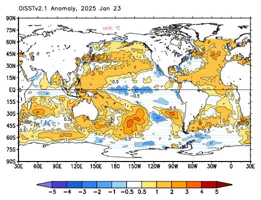
Just about all indicators are pointing to a moderately strong El Niño for the 2014/15 ENSO season. See the NOAA weekly ENSO update dated March 24, 2014. The subsurface temperature anomalies along the equatorial Pacific associated with the downwelling (warm) Kelvin wave are quite warm. See the cross sections on page 11 of the update:

Figure 1 – Equatorial Pacific Subsurface Temperature Cross Sections
Eventually, some (but not all) of that warm water will rise (be drawn) to the surface.
NOAA also animates those cross sections here.
Weekly NINO3.4 sea surface temperature anomalies (central equatorial Pacific) have crossed zero, from negative to positive, for the first time this year. Unless something unforeseen happens, I would not anticipate them returning to negative values for at least a year, during the transition from El Niño to the trailing La Niña.

Figure 2 – NINO3.4 Sea Surface Temperature Anomalies
Weekly NINO1+2 sea surface temperature anomalies (far eastern equatorial Pacific) are presently quite cool (about -1.0 deg C).

Figure 3 – NINO1+2 Sea Surface Temperature Anomalies
We’ll keep track of the NINO1+2 data because the NOAA/NCEP ENSO forecast (from their CFS.v2 model) now is for a moderate East Pacific El Niño, which are generally stronger than a Central Pacific El Niño (aka El Niño Modoki). The following is page 27 of the NOAA update linked above.

Figure 4 – CFS.v2 ENSO Model Forecast
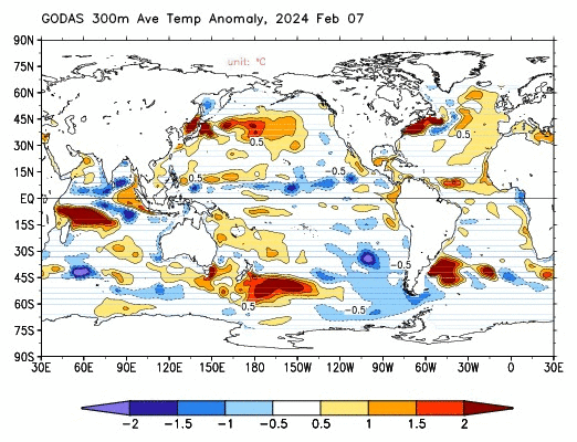
The NCEP GODAS website produces a number of interesting maps and they produce a monthly ocean briefing.
I’ve been downloading the GODAS sea surface temperature maps (see animation here), which are based on the Reynolds OI.v2 data, and their H300 maps (see animation here), the latter of which capture the subsurface temperature anomalies for the top 300 meters (roughly 1000 feet). The NCEP produces the maps on 5-day intervals (with the sea surface temperature maps trailing by about 2 weeks). I’m hoping to continue to download those two sets of maps to produce animations of side-by-side sea surface temperature and H300 maps, not only through the El Niño, but on into the trailing La Niña, so that we can try to keep track of the warm water AFTER the El Niño…
Regards
Bill Illis,
the last thing the debate needs a large El Nino
really? is that what you care about, “the debate”?
Sunspot count has been slightly elevated the past six months. A slight El Nino in 2014 would be expected. Nothing major though.
A big question I’d like to see answered is how long does it take for the warmer waters to proceed up the coast of California from Central America.
I have noticed in the past thirty plus years that the El Niño-like wetter winter conditions require one year to go from Southern California to Northern California.
My thoughts were the same as poster #1’s: Usually El Nino means more rain for us here in Texas, while La Nina brings more drought. We’re already low for the first three months of the year; bring on El Nino!!!!
CFSv2 has been calling for a moderate Nino for almost a year now. The entire time temperatures were flat and cooling, it was calling for warming. That model has no skill. Watch the trades.
Definitely looks like El Nino, I’ll go for 2009-like moderate strength. If that’s the case there’s unlikely to be much warming. Imagine that, an El nino with hardly any warming-they’d be out of excuses then for sure!
In any case, let’s all hope California makes the most of it.
As for Ken Ring, I’d say his forecast has about as much chance as the Jade Rabbit.
jai mitchell says:
“Bill Illis,
the last thing the debate needs a large El Nino
really? is that what you care about, “the debate”?”
Yes, we are more concerned with the debater than the weather or the Climate, as it is the insane spin-offs from the debate which are hurting the whole Earth’s population, not the weather or the Climate. The weather and the Climate are just fine as they have always been, and we can adapt to warmer or cooler, but insane government legislation is much harder to dodge. It is the insane debate which is causing the damage.
Nino 2014 will fizzle out. When +0.1C ENSO3.4 meets -1.2C ENSO 1+2, the candle flickers and then goes out.
Some enhanced rain though for the west coast and SW USA. 🙂
Theres been a lot of discussion at Weatherzone as to where this possible ENSO event might be headed.
http://forum.weatherzone.com.au/ubbthreads.php/topics/1225860/33/ENSO_Discussion_2014
The 1997 event was kicked off by a Kelvin wave generated in December 1996 that was followed by 2 stronger waves in March and May. The initial kelvin wave in December 1996 was strong enough to push positive sea level anomalies all the way across to the coast of South America but the real strength of the event was generated by the follow up waves.
This event is a little different. the initlal kelvin wave to kick of the event has come nearly 2 months later and to date has not pushed positive sea level anomalies to far into the equatorial East Pacific. Although you can certainly see some enhancement of the equatorial counter current in the Northern Hemisphere on SST charts which is something that generally accompanies El Nino events.
Even though their is evidence that warmer anomalies prime the central pacific for further waves, this is offset by the fact the later we get into the year the less frequent kelvin waves are.
In addition as mentioned in other posts above, the feed in from the Humboldt current is much cooler than it was in 1997.
I think we are at a crossroads at the moment. If we see another strong kelvin wave develop before the end of April its hard to see us avoiding a strong El Nino event. If no follow up occurs then I see a moderate event and perhaps only a Modoki.
I don’t personally see this El Nino as being likely to match the 1998 or 1982/3 ones. But we’ll see….
No one seems to have mentioned the float buoys. Aren’t around 40% nonfunctioning? Doesn’t this data gap diminish the model predictions reliability? This seems to have been forgotten, here and across the government climate prediction sources.
Let’s not forget that the 98 El Nino was exceptionally strong. A moderately strong El Nino won’t have nearly the same effects.
This discussion about the new El Nino made me think: alarmists use land + sea surface temperature records. When an El Nino happens warm water from the PWP is distributed across the surface. This means they will show up in the SST records but overall the heat content of the ocean hasn’t changed. If SST records do show warming after the El Nino then claiming that the world has warmed would be a false claim.
The seas around Australia have been warming for the last decade thanks (I think) to the La Ninas. A mild El Nino might take the heat out of things here. It will be interesting to see.
NOAA’s recent ENSO forecast have
been lousy.
With the PDO not changing-watch out!
I sure wish someone would decipher the code here.
Be aware of the SPRING BARRIER: seasonal prediction of the next phase of ENSO is particularly difficult during spring until June. After that, once it is established what the ENSO phase and strength will be, predictability ahead becomes very high. Until the next spring, that is …
There are a ton of research papers discussing the matter. I wouldn’t bet my life on the next ENSO phase …
http://www.cpc.ncep.noaa.gov/products/outreach/proceedings/cdw30_proceedings/P2.25.ppt
Very interesting stuff.
So where is this heat coming from? The cross-sectional area and the amplitude of the temperature anomaly is clearly increasing notably and is not being communicated from the surface. This is not just an east-west spreading of warmer water in the west Pacific warm pool.
That means it must be coming form outside the band of latitudes that this graph represents.
That in turn means heat energy is being moved into the tropics from either the north, the south or both. Yet further evidence that the fundamental cause of ENSO phenomena is sub-surface tidal displacement of water, not trade winds and “sloshing” as is the consensus explanation.
Correlations across the Pacific show some zones are in phase with Nino34 and others are in anti-phase. This is part of a basin wide tidal oscillation at the level of the thermocline.
Other than an improbably randomly driven oscillation this is probably a tidal phenomenon.
If an El Nino happens late in the year, so that it is split across two years, neither of them is likely to be a record-setter.
Greg Goodman says:
March 25, 2014 at 1:42 am
“Other than an improbably randomly driven oscillation this is probably a tidal phenomenon.”
Given that the ‘hot spots’ if the below picture of sea surface temperatures are rather nicely distributed at 30 to 40 degrees both North and South of the equator in all the oceans this may indeed be some sort of run around the ends rather than a pass down the middle.
http://weather.unisys.com/surface/sst_anom_new.gif
I think if an El Nino was going to happen this year it would have shown itself by now (by the middle of January usually). I think we’ll be in ENSO neutral at least until the middle of July (It takes aproximately 6 weeks from solstice for change to manifest itself).
We may even get a mild La Nina by October/November, giving the ocean enough time to charge itself for a moderate El Nino by the middle of next year.
Baa Humbug,
thats just about the dumbest comment I have ever read.
Thanks.
jai mitchell says:
March 24, 2014 at 7:03 pm
Why would you use a Linear trend to predict anything? At least use some form of continuous function.
http://climatedatablog.files.wordpress.com/2014/02/uah-global.png
http://climatedatablog.files.wordpress.com/2014/02/feb-rss-global-with-annual-ctrm-low-pass-filter-and-trend.png
Linear trend = Tangent to the curve = Flat Earth
[EDIT: sorry the urls got concatenated]
@- Steven Devijver
“… If SST records do show warming after the El Nino then claiming that the world has warmed would be a false claim.”
No it would be an accurate description of reality, because the surface would be warmer.
That the warming would be the result of ocean currents rather than directly from AGW is just how natural variations modify the AGW trend.
Describing the real warming from an El Nino as false would be like describing the present pause in the trend as false because it is just a oceanic ENSO/PDO/NAO blip….
eric1skeptic says:
March 24, 2014 at 4:09 pm
Yep. Every (every) damn time the warmista get antsy with my de-nile-ism they threaten me with the ‘next super El-Nino’ as in, JUST WAIT, YOU’LL SEE ….
So, a solar driven, natural event that has been known of for centuries is somehow my fault for burning stuff ???
Oh good, only another year until the east coast thaws out.