Just about all indicators are pointing to a moderately strong El Niño for the 2014/15 ENSO season. See the NOAA weekly ENSO update dated March 24, 2014. The subsurface temperature anomalies along the equatorial Pacific associated with the downwelling (warm) Kelvin wave are quite warm. See the cross sections on page 11 of the update:

Figure 1 – Equatorial Pacific Subsurface Temperature Cross Sections
Eventually, some (but not all) of that warm water will rise (be drawn) to the surface.
NOAA also animates those cross sections here.
Weekly NINO3.4 sea surface temperature anomalies (central equatorial Pacific) have crossed zero, from negative to positive, for the first time this year. Unless something unforeseen happens, I would not anticipate them returning to negative values for at least a year, during the transition from El Niño to the trailing La Niña.

Figure 2 – NINO3.4 Sea Surface Temperature Anomalies
Weekly NINO1+2 sea surface temperature anomalies (far eastern equatorial Pacific) are presently quite cool (about -1.0 deg C).

Figure 3 – NINO1+2 Sea Surface Temperature Anomalies
We’ll keep track of the NINO1+2 data because the NOAA/NCEP ENSO forecast (from their CFS.v2 model) now is for a moderate East Pacific El Niño, which are generally stronger than a Central Pacific El Niño (aka El Niño Modoki). The following is page 27 of the NOAA update linked above.

Figure 4 – CFS.v2 ENSO Model Forecast
The NCEP GODAS website produces a number of interesting maps and they produce a monthly ocean briefing.
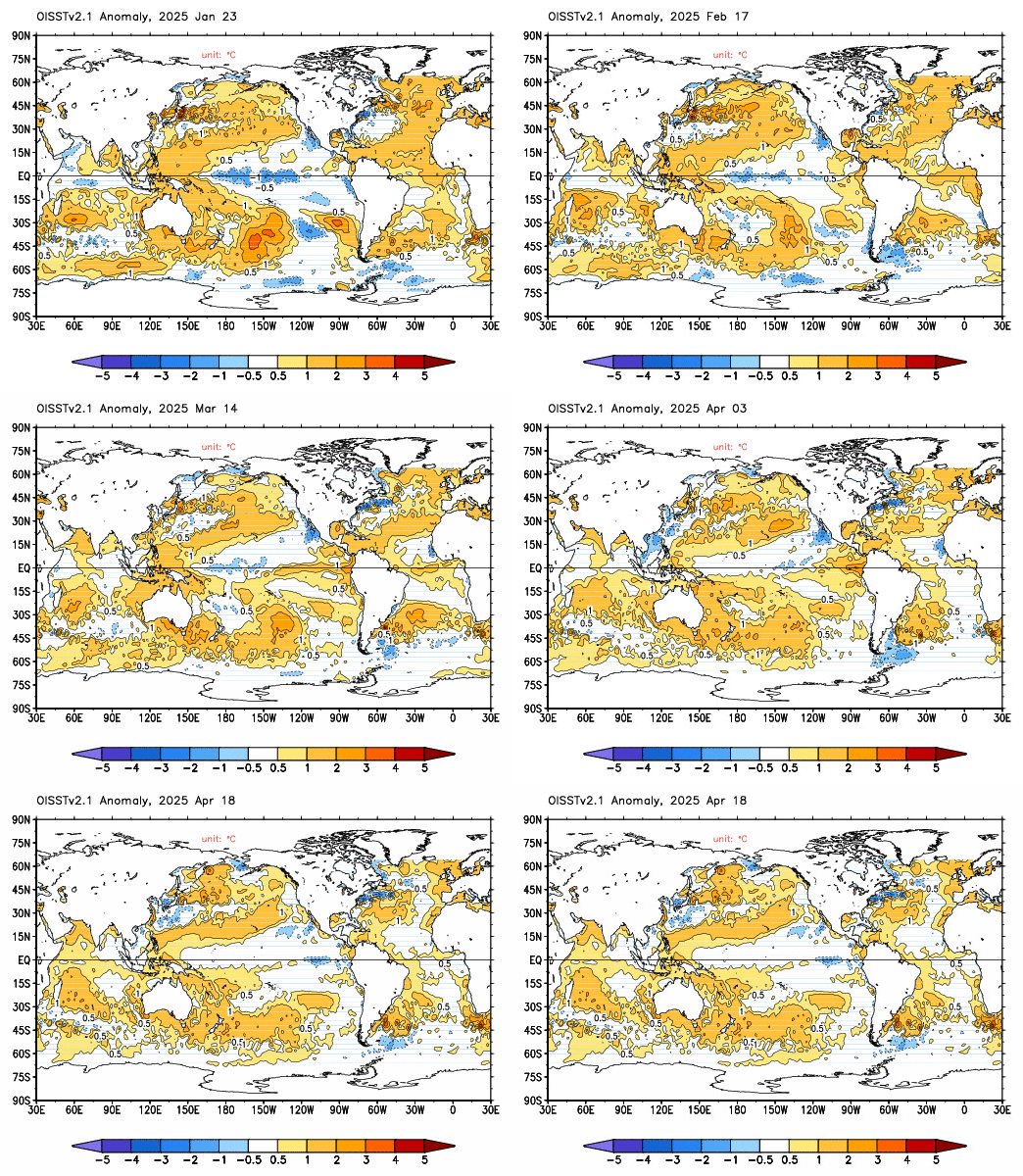
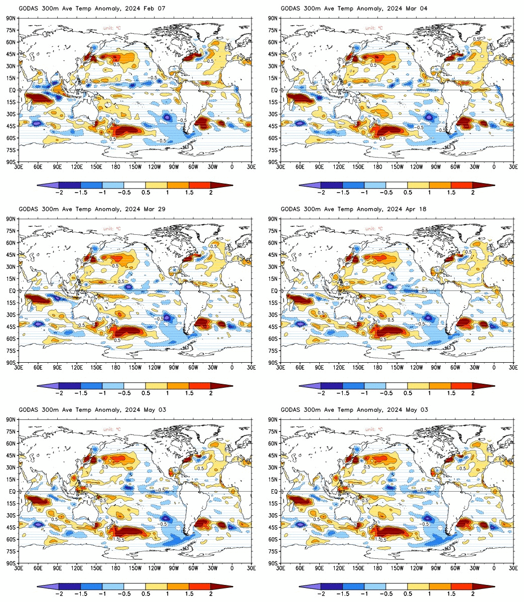
I’ve been downloading the GODAS sea surface temperature maps (see animation here), which are based on the Reynolds OI.v2 data, and their H300 maps (see animation here), the latter of which capture the subsurface temperature anomalies for the top 300 meters (roughly 1000 feet). The NCEP produces the maps on 5-day intervals (with the sea surface temperature maps trailing by about 2 weeks). I’m hoping to continue to download those two sets of maps to produce animations of side-by-side sea surface temperature and H300 maps, not only through the El Niño, but on into the trailing La Niña, so that we can try to keep track of the warm water AFTER the El Niño…
Regards
I see a weak EL nino starting about October and lasting for about 12 months
I think Greg’s point about the cause of an El Niño is important. I’ve been wondering the exact same thing. It appears the cause has to do with the warming of the subsurface waters rather than changes in trade winds or “sloshing”. These appear to be after effects once the warmer water reaches the surface. The warmer water would first cause the changes in the trade winds which would then allow gravity to push the PWP water to the east.
Greg mentioned tidal forces as the cause of the subsurface warming. I suppose it could also be warmer subsurface currents from the PWP simply due to an extended period of La Niña or La Nada conditions. As the PWP warmth builds the warm water is pushed downward and flows back to the east to replace the surface currents. Any other thoughts?
X Anonymous on March 25, 2014 at 3:45 am
Baa Humbug,thats just about the dumbest comment I have ever read.Thanks.
It’s actually quite a fair comment. This thread is a good chance to educate a few of our visitors who clearly are either learning about ENSO for the first time or have been indoctrinated that ENSO is nothing but noise. ENSO is phase locked, this was known by the Peruvian fishermen who first named it el Nino due to its appearence around Christmas, while this observation has none the less escaped many mainstream climate scientists.
Google-scholar “phase-locked” if you’re unfamiliar with the term; combine it with ENSO and you will run into a slew of terrifyingly enlightening papers on the dynamics of ENSO as a periodically forced nonlinear oscillator. With phase-locking of el Nino peaks at winter.
The current proto-el Nino is at the wrong time and under the wrong conditions and will be abortive.
I dont think it ultimately makes sense to look for a single cause of el Ninos since ENSO is a chaotic-nonlinear oscillator. While under entraining influences, in general it causes itself.
“A big question I’d like to see answered is how long does it take for the warmer waters to proceed up the coast of California from Central America.”
unless i’ve missed something somewhere, the ocean currents along the west coast run south towards the Equator, which means that it is, as i understand it, nigh unto impossible for the warmer waters to travel north.
what we get here in Failifornia is the effect of the warmer waters elsewhere on our weather.
redc1c4: I think there’s actually a counter-current that hugs the coast going north, especially south of Pt. Conception. So, some warmer waters from an El Nino do make their way at least that far north during an El Nino.
Based on my Artificial Neural Network for ENSO studies which shows that ENSO is mainly driven by a combination of tidal forcing, magnetic forcing and by sea current inertia, I find it unlikely that ENSO is going to be in a El Niño state at the end of this year.
Instead what I expect ENSO to be, is in a La Niña or neutral state at the end if this year.
Of course based on the recent changes in the SOI index, the ENSO index is going to rise in the next coming 2 or 3 months. After that time I think the index is going to fall.
So this is going to be an interesting test for me.
Right now I’m working on making similar forecast for LOD and SOI which should improve my forecast for ENSO.
In the coming following years the ENSO index is going to drift to higher values with alternating neutral and El Niño values. Expect a moderate El Niño at the end of next year.
I’ve been watching the ENSO meter ever since Anthony installed it. Cool device!
But I was also thinking that the meter (ENSO) might spend more time leaning towards el Niño this summer instead of leaning towards la Niña.
But now NOAA goes and predicts an el Niño this year. That needle will be lucky if it’s not pegged la Niña all year. NOAA’s track record on predicting el Niño’s is terrible.
One of the forecasting ensembles that the Australian Bureau of Meteorology uses is now showing a tropical storm near the Solomon Islands at the end of March with a strong cross equatorial infeed.
Such a system would likely generate another WWB and make it almost certain that we will see a strong El Nino this year. The gun is currently cocked. All it needs now is the trigger.
Hopefully the forecast turns out to be inaccurate (given its 5 days out). The current kelvin wave appears to have nearly run its course so if we do avoid another kelvin wave then any El Nino event wont be as strong.
Any talk of a Super El Nino is just nonsense. There is cooler water already following the Kelvin Wave into the Equatorial Pacific. We would need to see follow up kelvin Waves and i can’t see any in the pipeline.
Also, jamstec is firm on a modoki peaking by october. And the thing about the Cold PDO is that it doesn’t stay warm for too long. And it won’t, it will begin in the Bering Sea and feed down into the Central Pacific during the next few months.
Also, 1 and 2 still look like staying fairly cool so at this stage this is going to be nothing like 1997/98, despite the warmth in the subsurface. Not forgetting also in 2012 models were predicting one also when a pool of warmth appeared in the subsurface. The pacific stated to warm and then was quickly chewed away by the cold Humboldt.
Bob Tisdale himself actually produced a youtube clip of the immense Kelvin Wave of the super El Nino, showing sea height anomalies. maybe Bob you can find the post again?
This one at this stage is nowhere near it. That said I’m hoping for a moderate event as we will see a thumping La nina to follow.
This current warmth in the ENSO should peak by June, then fade back to the cool side of the meter by the end of summer. This coming fall should be a La Nina with a peak in Nov/Dec. After that is where an El Nino will start at the beginning of next year. That El Nino will be short lived and ENSO will then head into a multi year strong La Nina. This all assumes that the connection which I think I am seeing turns out to have validity. At least it won’t take 80 years to find out if it is right.
re: Henry Galt says:
March 25, 2014 at 4:56 am
Henry, I recently saw a frustrated, demoralized warmist say: “I can’t wait for that El Nino to start this Summer… Maybe we can hear the last of the false “no warming for 17 years” lies.”
I found that quite amusing. They were essentially saying ‘I can’t wait for the next naturally driven “warming” event so that we can we can say that human driven warming is still happening’!
X Anonymous says:
March 25, 2014 at 3:45 am
Thankyou for that well thought out detailed contribution. Always happy to get a response from well read contributors.