UPDATE: Live The last radar image from Willis Island added below. The last radar image is truly striking.
Also, see below for the differences between the Australia hurricane scale and the familiar Saffir-Simpson scale used in the USA. They are not equal.
From Australia’s BoM, time to “get outta Dodge” as they say:

Simon at Australian Climate Madness notes this for rebuttal of the inevitable “Yasi caused by global warming” links that will be pushed on the blogs and by the press:
Tropical cyclone Mahina hit on 4 March 1899. It was a Category 5 cyclone, the most powerful of the tropical cyclone severity categories. In addition, Mahina was perhaps one of the most intense cyclones ever observed in the Southern Hemisphere and almost certainly the most intense cyclone ever observed off the East Coast of Australia in living memory. Mahina was named by Government Meteorologist for Queensland Clement Wragge, a pioneer of naming such storms.
Here’s what BoM has to say on their tracking page:
The forecast path shown above is the Bureau’s best estimate of the cyclone’s future movement and intensity. There is always some uncertainty associated with tropical cyclone forecasting and the grey zone indicates the range of likely tracks of the cyclone centre.
Due to the uncertainty in the future movement, the indicated winds will almost certainly extend to regions outside the rings on this map. The extent of the warning and watch zones reflects this.
This product is designed for land-based communities; mariners should read the coastal waters and high seas warnings.
Remarks:
SEVERE TC YASI IS A LARGE AND VERY POWERFUL TROPICAL CYCLONE AND POSES AN EXTREMELY SERIOUS THREAT TO LIFE AND PROPERTY WITHIN THE WARNING AREA, ESPECIALLY BETWEEN CAIRNS AND TOWNSVILLE.
THIS IMPACT IS LIKELY TO BE MORE LIFE THREATENING THAN ANY EXPERIENCED DURING RECENT GENERATIONS.
TC Yasi, CATEGORY 5, will continue to move in a west-southwesterly direction during the day. The cyclone is expected to cross the coast in the Innisfail area at about midnight.
Coastal residents within the warning area, and particularly between Cairns and Ayr are specifically warned of an EXTREMELY DANGEROUS SEA LEVEL RISE [i.e. storm tide] as the cyclone approaches, crosses the coast and moves inland. The sea is likely to steadily rise up to a level which will be VERY DANGEROUSLY above the normal tide, with EXTREMELY DAMAGING WAVES, STRONG CURRENTS and FLOODING of low-lying areas extending some way inland. People living in areas likely to be affected by this flooding should take measures to protect their property as much as possible, and be prepared to follow instructions regarding evacuation of the area if advised to do so by authorities.
DAMAGING WINDS with gusts to 90 km/hr that are currently developing on coastal islands, are forecast to develop about the coast by late morning and about the tropical interior overnight.
Between Cape Tribulation and Ingham these winds will become DESTRUCTIVE with gusts in excess of 125km/hr during the afternoon and early evening and VERY DESTRUCTIVE with gusts up to 300 km/hr between Cairns and Ingham during the evening as the cyclone approaches and crosses the coast. These VERY DESTRUCTIVE winds can also occur on the seaward side of hills to the north of the cyclone and are also forecast to reach the Atherton Tablelands.
Winds are forecast to ease about the east coast during Thursday morning as the cyclone moves inland.
FLOODING RAINS will develop from Cooktown to Sarina during the afternoon and then extend inland overnight.
People between Cape Melville and Sarina, extending inland to Croydon and Richmond should complete preparations quickly and be prepared to shelter in a safe place.
– Boats and outside property should be secured.
– For cyclone preparedness and safety advice, visit Queensland’s Disaster Management Services website (www.disaster.qld.gov.au)
– For emergency assistance call the Queensland State Emergency Service (SES) on 132 500 (for assistance with storm damage, rising flood water, fallen trees on buildings or roof damage).
People about the remaining tropical interior east of Camooweal and north of Winton should consider what action they will need to take if the cyclone threat increases.
– Information is available from your local government
– For cyclone preparedness and safety advice, visit Queensland’s Disaster Management Services website (www.disaster.qld.gov.au)
– For emergency assistance call the Queensland State Emergency Service (SES) on 132 500 (for assistance with storm damage, rising flood water, fallen trees on buildings or roof damage).
Name: Severe Tropical Cyclone Yasi
Details:
| Time (EST) | Intensity Category | Latitude
(decimal deg.) |
Longitude
(decimal deg.) |
Estimated Position
Accuracy (km) |
|
|---|---|---|---|---|---|
| 0hr | 7 am February 2 | 5 | 16.1S | 150.9E | 20 |
| +6hr | 1 pm February 2 | 5 | 16.7S | 149.1E | 45 |
| +12hr | 7 pm February 2 | 5 | 17.2S | 147.5E | 75 |
| +18hr | 1 am February 3 | 4 | 17.8S | 145.8E | 100 |
| +24hr | 7 am February 3 | 2 | 18.5S | 144.1E | 130 |
| +36hr | 7 pm February 3 | 1 | 19.8S | 141.1E | 190 |
| +48hr | 7 am February 4 | tropical low | 20.9S | 138.4E | 250 |
The next Forecast Track Map will be issued by 11:00 am EST Wednesday
===============================================================
UPDATE:
Commenter sHx writes:
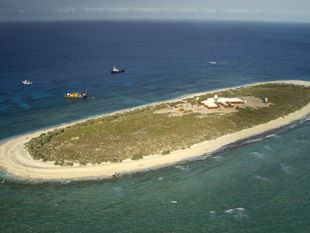
AS of this moment Yasi is right on top of Willis Island. http://en.wikipedia.org/wiki/Willis_Island
Apparently the island has a meteorological post. It even has radar! http://www.bom.gov.au/products/IDR412.loop.shtml

It must be frightening to be that radar operator looking at this, knowing when that eyewall hits you are going to be subject to Cat5 winds and you have a 30meter tall radar tower right next to you, and there’s really no shelter elsewhere on the island and no place to go. I wonder how long we’ll continue to get a signal from the Willis Island’s radar?
UPDATE2: Just about the time I pressed “update” the radar went out, the radar station is offline. The last image from the station is above. We hope for the best for the BoM employees there. The storm surge must be ferocious. Hopefully BoM evacuated them and they left the radar on “auto”. Given the size and composition of the island versus the size of the hurricane, Willis Island may very well be erased by this storm.
===============================================================
Good luck to our friends in Queensland, especially Dr. Bob Carter and Nigel, who helped during my tour in Townsville last year.
===============================================================
UPDATE 3: Hurricane expert Dr. Ryan Maue brings to our attention the differences in tropical cyclone scales. The Saffir-Simpson scale used maximum sustained one-minute winds while the Australian Region scale uses ten-minute averaged sustained winds. The convention to convert is (10-minute)*1.14 = 1-minute sustained (units are knots). This image combined from Wikipedia’s article.

The JTWC advisory intensity at 00Z Feb 2 of 125 knots is a strong Category 4 on the Saffir-Simpson scale. The Australian Bureau of Meteorology reports central pressure of 930 hPa, and backs out Category 5 winds from that. Also, feel free to call Yasi a “willy-willy“.
Discover more from Watts Up With That?
Subscribe to get the latest posts sent to your email.
Why do these big storms always seem to hit at midnight, the worst.
I’m praying for them all……
OMG! Be save!
Time to boogy Mates, this is not one to arm wrassle with.
Not much we can do to help you all at this time, but we’ll keep our fingers crossed anyway. I think my Aussie Mate Harro is right in the middle of that smash zone too; so get your A*** out of there buddy, and take the lovely lady with you.
GES
Yes Good Luck to everyone in the areas to be affected
Someone sent me this link yesterday the Hayden Walker Long range weather site at the link below
there are some amazing further links there. The page linked to is the end page, and to get back to his home page, just scroll back through the links at each page that say previous.
The practice of naming Cyclones was in fact started by a predecessor of Walker’s, Clem Wragge, who started this long range weather forecasting and that is at the second link, also from Hayden Walker’s site.
Link to Hayden Walker Page: http://www.worldweather.com.au/Meteor.htm
Link to History: http://www.worldweather.com.au/History.htm
(thanks to TonyfromOz)
Actually, if you check it right now, it looks like the radar loop has stopped. This happened within the last hour, putting it between my reminder and Anthony’s update.
And right now, there is only this message:
Radar service is currently unavailable due to:
Sorry outage information is currently unavailable.
Courier Mail in Brisbane has regular update. http://www.couriermail.com.au/news/north-queensland-braces-for-cyclone-anthony-as-cyclone-yasi-brews-behind-it/story-e6freon6-1225997552623
They reported at 10.04 AEST that the weather station may have been destroyed.
god help them all
Category 5 on the Australian Cyclone Scale, not the familiar Saffir Simpson we use in the Atlantic…
The current intensity is 130 knots (1-minute sustained), and is not forecast to increase. Yasi will likely entrain some dryer continental air prior to landfall and be at 110-120 knots, or a moderate Category 4.
REPLY: Well I learned something today. I thought the Saffir Simpson scale was universally used. I’ll have to make a note now. Thanks -Anthony
According to reports the weather station on Willis Island has stopped reporting.
New reports are estimating expected wind gusts of up to 320Kilometres per hour (200 mph)
Have a look through this graphic PDF
Cyclone PDF
Note the table in the top left hand corner – destructive power of winds in KHM.
380KMH winds and above + total destruction
Unfortunately, this will be a wet to remember. Hope all my old mates are well stocked with XXXX and Bundaberg rum.
This cyclone is much FURTHER south then the earlier Cat 5 mentioned here. The 1899 Mahina cyclone also hit a mainly unpopulated Cape York. It went southwest over Cape York Peninsula, emerging over the Gulf of Carpentaria before doubling back and dissipating on 10 March.
Further noting about Mahina it was nearly two months later. The BOM computer modelling along with the CSIRO predicted these cyclones in their modelling. A shift of a 2 degrees latitude in a modelled global WARMING world also predicted the rainfalls QLD has been experiencing.
Here it is word for word PREDICTED in climate models and QLD Government Climate Statement!
Extreme rainfall is defined as the amount of rain falling in the top one per cent of rainfall days. Projections based on 15 climate models and a medium emissions (A1B) scenario indicated that Cape York can expect up to a four per cent increase
in extreme rainfall across all seasons, and that western Queensland and the Gulf Region can expect up to a four per cent increase in summer and autumn (CSIRO & BoM 2007).
Climate change is also likely to affect extreme rainfall in south-east Queensland (Abbs et al. 2007). Projections indicate an increase in two-hour, 24-hour and 72-hour extreme rainfall events for large areas of south-east Queensland, especially
in the McPherson and Great Dividing ranges, west of Brisbane and the Gold Coast. For example, Abbs et al. (2007) found that under the A2 emissions scenario, extreme rainfall intensity averaged over the Gold Coast sub-region is projected to increase
by 48 per cent for a two-hour event, 16 per cent for a 24-hour event and 14 per cent for a 72-hour event by 2070. Therefore despite a projected decrease in rainfall across most of Queensland, the projected increase in rainfall intensity could result in more
flooding events.
http://www.climatechange.qld.gov.au/pdf/climate-change-in-queensland-2010.pdf
It is of course fine to be a climate skeptic – but if may I am in QLD right now. It’s enough to knock the skeptic out of anyone.
Climate Change skeptical extinction may be expected by 2020.
Willis Island is supposed to provide an update every 10 minutes I believe. The transmissions have apparently now ceased. Looking at the pic Anthony provided, I’m not surprised.
The storm surge would put it under water wouldn’t it ?
regarDS
Laid back aussies or the worst weather forecast ever?
http://www.australianexplorer.com/weather/innisfail.htm
“Windy later”
Good luck you guys.
Anthony,
The amount of water damage will depend on the exact time that this cyclone affects the coastline. Last I heard was that it would cross around Innisfail (83 kms south of Cairns) at about midnight.
If it accelerates slightly this would put it at the same time at quite a high tide (estimated at 2.38m at 2053 hrs for Cairns) which would be the worst case scenario.
300kmh gusts = 161 knots or 186 mph Ouch!
All of the modern houses are built to cyclone wind standards in FNQ (Far North Queensland) but coastal flooding will be a major issue. Also flying debris such as cars , trees and sharp sheet metal commonly used on roofs can damage structures that could take the wind fine without such structural damage.
The massive Burdekin dam and many others are already overflowing and the rainfall from Yasi is going to be extreme. Expect significant flooding in river systems downstream of all the full dams. My home town of Mt Isa is at the tail end – 800km (497 miles) from the coast and this will still be a category 1 cyclone when it gets there!
If it goes up into the gulf of Carpentaria it could reform…….
According to this page, the weather station on Willis Island last reported CALM conditions with wind at 0 kmh. 🙂
http://www.bom.gov.au/products/IDQ60801/IDQ60801.94299.shtml
BTW, Anthony, I can’t guarantee you this, but rest assured any living personnel on the island would have been evacuated by now.
Ross, better get prepared. The bad weather you are talking about is going to happen with or without global warming. It may come more frequently with global warming. It may also be higher intensity although high intensity is also an historical fact. So be prepared!
Ross Brisbane says:
February 1, 2011 at 3:45 pm
Piers Corbyn predicted extreme weather for eastern Oz during the period 29th Jan to 2nd Feb and he didn’t include AGW or CO2 in his calculations.
I’ve been telling friends and family of a climate shift accompanied by extreme weather for many months now. Nothing to do with CO2.
What’s happening and been happening in this part of the world is nothing new, just the 35.8yr cycle cycling away as expected. The warm waters around the eastern coast of Oz are a product of La Nina pushing warm waters in a westerly direction against the Oz and PNG coasts.
Why don’t you visit the WUWT Enso page and do a little reading before falling in line with the AGW meme. These extreme weather events would have happened with or without the extra bit of CO2.
For comparison of the scale of this Cyclone with US hurricanes scales see bottom of the page
http://www.bom.gov.au/cyclone/about/intensity.shtml
The 4 BoM employees on Willis Island were evacuated before the cyclone hit,
according to the very informative post be Les Francis.
Seems the only rational move when a storm that size washes over the site.
The rainfall from this system will be a serious blow to the area, which is already suffering from record flooding.
Co-incidentally we had a tropical cyclone heading directly for Perth less than a week ago. And in fact the remains of cyclone came directly over downtown Perth. However, the cyclone had rapidly decayed and all we got was 12 hours of drizzle with light winds.
A BoM spokeperson was on TV afterwards telling us how we had ‘dodged a bullet’. No mention of the fact their forecast of 100KPH winds was completely wrong.
Note, no implication the QLD cyclone will be a similar bust.
Nonsense, these predictions were made by models. Until the error bars get narrower I suggest we ignore them
The Courier Mail reported a few hours ago the staff were evacuated:
9.30am Wind gusts are reaching 140km/h at Willis Island off the coast of Queensland. The tiny island is in the direct path of the cyclone and is home to a Bureau of Meteorology weather station. Three bureau staff have been evacuated.
Ryan Maue says:
February 1, 2011 at 3:37 pm
Category 5 on the Australian Cyclone Scale, not the familiar Saffir Simpson we use in the Atlantic…
The current intensity is 130 knots (1-minute sustained), and is not forecast to increase. Yasi will likely entrain some dryer continental air prior to landfall and be at 110-120 knots, or a moderate Category 4.
========================================================
1 knot = 1.852 km/hr
130 knots = 241 km/hr
Hey Ross of Brisbane,
“It is of course fine to be a climate skeptic – but if may I am in QLD right now. It’s enough to knock the skeptic out of anyone.
Climate Change skeptical extinction may be expected by 2020.”
Ross a lot of readers here might not realise that although you are in Qld if you are in Brisbane then you are a long way away from this storm. I lived in Cairns for 2 years and Trop Cyclones hovered around the coast about 4 per season. Only one touched land just south of Cairns in my time. Mate, it is a weather event not Global Warming or Climate Change. It will be massive, there will be destruction and there could well be deaths. It may also not be the last one for the season which runs for a few more months yet.
The nicest, most civilized people always seem to live in the cruelest, most inhospitable climate. G’day. No worries. I’ll pray for you.