Here’s the view of La Niña today:

The Multivariate ENSO Index (MEI)
by Klaus Wolter, NOAA Earth Systems Research Laboratory

El Niño/Southern Oscillation (ENSO) is the most important coupled ocean-atmosphere phenomenon to cause global climate variability on interannual time scales. Here we attempt to monitor ENSO by basing the Multivariate ENSO Index (MEI) on the six main observed variables over the tropical Pacific. These six variables are: sea-level pressure (P), zonal (U) and meridional (V) components of the surface wind, sea surface temperature (S), surface air temperature (A), and total cloudiness fraction of the sky (C). These observations have been collected and published in COADS for many years.
The MEI is computed separately for each of twelve sliding bi-monthly seasons (Dec/Jan, Jan/Feb,…, Nov/Dec). After spatially filtering the individual fields into clusters (Wolter, 1987), the MEI is calculated as the first unrotated Principal Component (PC) of all six observed fields combined. This is accomplished by normalizing the total variance of each field first, and then performing the extraction of the first PC on the co-variance matrix of the combined fields (Wolter and Timlin, 1993). In order to keep the MEI comparable, all seasonal values are standardized with respect to each season and to the 1950-93 reference period. The MEI is extended during the first week of the following month based on near-real time marine ship and buoy observations (courtesy of Diane Stokes at NCEP) summarized into COADS-compatible 2-degree monthly statistics at NOAA-ESRL PSD. Caution should be exercised when interpreting the MEI on a month-to-month basis, since the input data for updates are not as reliable as COADS, and the MEI has been developed mainly for research purposes. Negative values of the MEI represent the cold ENSO phase, a.k.a.La Niña, while positive MEI values represent the warm ENSO phase (El Niño).
You can find the numerical values of the MEI timeseries under this link, and historic ranks under this related link. You are welcome to use any of the figures or data from the MEI websites, but proper acknowledgment would be appreciated. Please refer to the (Wolter and Timlin, 1993, 1998) papers (NOW available online as pdf files!), and/or this webpage.
If you have trouble getting the data, please contact me under (Klaus.Wolter@noaa.gov)

How does the 1998-2000 La Niña event compare against the seven previous biggest La Niña events since 1949? Only strong events (with a peak value of at least -1.2 sigma) are included in this figure. Note that some events last through the full three years shown here (for instance, 54-56), while others revert to “normal” or El Niño conditions by the second or third year (especially in 64-66). The 1998-2000 La Niña does not resemble any previous event in this comparison figure. It started late (about three months later than the previous latest case), and it featured a superimposed annual cycle (peaking around May and troughing around November) that does not match the other events displayed in this figure. However, the weak La Niña period after the 1982-83 El Niño had similar characteristics. Click on the “Discussion” button below to find the comparison of 2010 MEI conditions against several strong La Niña events.

How does the 2002-04 El Niño event compare against the seven previous biggest El Niño events since 1949? Aside from 2002-04, only strong events (with a peak value of at least +1.4 sigma) are included in this figure. The 2002-03 El Niño event peaked below that threshold, with just over +1.2 sigma in early 2003. Overall, I would rank it just barely in the top 10 El Niño events of the last half century. In its evolution, it bears some resemblance to the 1965-67 event (highest temporal correlation), but shared with 1991-93 its reluctance to drop below the zero line once it had run its course. The El Niño event of 2006-07 reached a similar peak as the 2002-03 event, but lacked ‘staying power’, and collapsed in early 2007. The most recent event (2009-10) will replace 2002-03 in this comparison figure by the middle of 2011. Click on the “Discussion” button below to find the comparison of 2010 MEI conditions against several strong La Niña events.

The six loading fields show the correlations between the local anomalies and the MEI time series. Land areas as well as the Atlantic are excluded and flagged in green, while typically noisy regions with no coherent structures and/or lack of data are shown in grey. Each field is denoted by a single capitalized letter and the explained variance for the same field in the Australian corner.
The sea level pressure (P) loadings show the familiar signature of the Southern Oscillation: low pressure anomalies in the west and high pressure anomalies in the east correspond to negative MEI values, or La Niña-like conditions. Consistent with P, U has positive loadings mostly west of the dateline, corresponding to easterly anomalies along the Equator. The meridional wind field (V) features its scattered negative loadings north of the Equator across the eastern Pacific basin, denoting the northward shift of the ITCZ so common during La Niña conditions, juxtaposed with large positive loadings northeast of Australia.
Both sea (S) and air (A) surface temperature fields exhibit the typical ENSO signature of a wedge of positive loadings stretching from the Central and South American coast to the dateline, or cold anomalies during a La Niña event. Negative loadings north and east of Australia contribute significantly to the overall temperature pattern. At the same time, total cloudiness (C) tends to be decreased from the central to the western equatorial Pacific, and decreased close to equatorial South America as well as over Indonesia.
The MEI now stands for 26.1% of the explained variance of all six fields in the tropical Pacific from 30N to 30S, having regained more than 8% since May/June. For comparison, this value is 1.5% lower than the one registered in 1997, attesting to an overall weakening of ENSO variability in the last decade, but not as much as last month or even last August-September, since the large size of the current event is starting to register in this metric. The loading patterns shown here resemble the seasonal composite anomaly fields of Year 0 in Rasmusson and Carpenter (1982).

Consistent with the continued strengthening of La Niña conditions, all of the key anomalies in the MEI component fields that exceed or equal one standard deviation, or one sigma (compare to loadings figure), flag typical La Niña features, while no comparable El Niño-like features reach the opposite one sigma threshold. Significant negative anomalies (coinciding with high positive loadings) denote strong easterly anomalies (U) along the Equator and west of the dateline (up to -2.5 standard deviations), anomalous northerly anomalies (V) north of Indonesia, while both sea surface (S) and air temperature (A) anomalies continue to show -1 to -1.5 standard deviations in the central and eastern tropical Pacific basin. Significant positive anomalies (coinciding with high negative loadings) denote strong positive sea level pressure (P) anomalies (up to +2.5 standard deviations) over the southeastern (sub-)tropical Pacific, very strong westerly (U; up to 3.2 standard deviations) and strong southerly wind anomalies (V; up to 2.2 sigma) over the northeastern tropical Pacific, warm sea surface (S) and air temperature (A) anomalies, the latter up to +2.9 sigma, and increased cloudiness (C) north of Java. Again, all of these cardinal anomalies flag La Niña conditions.
Go to the discussion below for more information on the current situation.
If you prefer to look at anomaly maps without the clustering filter, check out the climate products map room.
Discussion and comparison of recent conditions with historic La Niña events

In the context of recent plunge of the MEI into strong La Niña conditions, this section features a comparison figure with strong La Niña events that all reached at least minus one standard deviations by June-July, and a peak of at least -1.4 sigma over the course of an event. The most recent bigger La Niña events of 1998-2001 and 2007-09 did not qualify, since they either did not reach the required peak anomaly (the first one) or became strong too late in the calendar year (both).
The most recent (August-September) MEI value shows a continued drop from earlier this year, reaching -1.99, or 0.18 sigma below last month’s value, and 3.39 standard deviations below February-March, a record-fast six-month drop for any time of year, while slowing down a bit at the shorter time scales. The most recent MEI rank (lowest) is clearly below the 10%-tile threshold for strong La Niña MEI rankings for this season. One has to go back to July-August 1955 to find lower MEI values for any time of year.
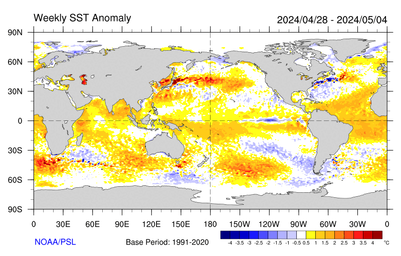
Negative SST anomalies are covering much of the eastern (sub-)tropical Pacific in the latest weekly SST map. Many of these anomalies are in excess of -1C.
For an alternate interpretation of the current situation, I highly recommend reading the latest NOAA ENSO Advisory which represents the official and most recent Climate Prediction Center opinion on this subject. In its latest update (7 October 2010), La Niña conditions are expected to last at least into the Northern Hemisphere spring of 2011.
There are several other ENSO indices that are kept up-to-date on the web. Several of these are tracked at the NCEP website that is usually updated around the same time as the MEI, in time for this go-around. Niño regions 3 and 3.4 showed persistent anomalies above +0.5C from June 2009 through April 2010, with a peak of +1.6C for Niño 3 and +1.8C for Niño 3.4 in December 2009, only to drop to about -0.5C or lower in both regions by early June 2010, reaching just shy of -1.0C for the month of July, and below -1.5C for September Niño 3.4 anomalies and below -1.2C for Niño 3. For extended Tahiti-Darwin SOI data back to 1876, and timely monthly updates, check the Australian Bureau of Meteorology website. This index has often been out of sync with other ENSO indices in the last few years, including a jump to +10 (+1 sigma) in April 2010 that was ahead of any other ENSO index in announcing La Niña conditions. After a drop to +2 in June, July rebounded to +20.5, August continued at an impressive +18.8, only to be followed by an even more impressive +25.0. The last time that this index showed higher values in September was back in 1917, which was also the only time on record that this happened for this month. An even longer Tahiti-Darwin SOI (back to 1866) is maintained at the Climate Research Unit of the University of East Anglia website, however with less frequent updates (currently through March 2010). Extended SST-based ENSO data can be found at the University of Washington-JISAO website, currently updated through May 2010 (which ended up just slightly below the long-term mean value).
Stay tuned for the next update (by November 5th) to see where the MEI will be heading next. After peaking seven months ago at +1.5, it has dropped just about as fast as it can, and continues to correlate highest with 1970, of the ‘analog’ cases shown here. Given the continued drop in the MEI into exceptionally strong territory, La Niña conditions are guaranteed well into 2011.
REFERENCES
- Rasmusson, E.G., and T.H. Carpenter, 1982: Variations in tropical sea surface temperature and surface wind fields associated with the Southern Oscillation/El Niño. Mon. Wea. Rev., 110, 354-384. Available from the AMS.
- Wolter, K., 1987: The Southern Oscillation in surface circulation and climate over the tropical Atlantic, Eastern Pacific, and Indian Oceans as captured by cluster analysis. J. Climate Appl. Meteor., 26, 540-558. Available from the AMS.
- Wolter, K., and M.S. Timlin, 1993: Monitoring ENSO in COADS with a seasonally adjusted principal component index. Proc. of the 17th Climate Diagnostics Workshop, Norman, OK, NOAA/NMC/CAC, NSSL, Oklahoma Clim. Survey, CIMMS and the School of Meteor., Univ. of Oklahoma, 52-57. Download PDF.
- Wolter, K., and M. S. Timlin, 1998: Measuring the strength of ENSO events – how does 1997/98 rank? Weather, 53, 315-324. Download PDF.
The views expressed are those of the author and do not necessarily represent those of NOAA.
Discover more from Watts Up With That?
Subscribe to get the latest posts sent to your email.
pochas says:
October 11, 2010 at 6:02 pm
Principle Components Analysis
————–
Really enjoyed your poem, especially the the “And temps adjusted back and forth” part. Wicked analogy!
El Ninos and La Ninas are just rhythmic upwellings of masses of water of different temperature. You can see the same thing in a bucket of water, but in the Pacific it is bigger and takes longer. That’s all of it. Can all the people writing their Ph.D. dissertations on it stop now?
Geoff Sharp says:
October 11, 2010 at 6:20 pm
This Solar Cycle isn’t going anywhere anytime soon, having just recently had the stuffings knocked out of it
What should be strong latitudinal bands in the EUV are now circular splotches, or a blank stare.
Like this: http://stereo-ssc.nascom.nasa.gov/beacon/latest_256/behind_euvi
and this: http://stereo-ssc.nascom.nasa.gov/beacon/latest_256/ahead_euvi
Links above should be:
http://stereo-ssc.nascom.nasa.gov/beacon/latest_256/behind_euvi_195_latest.jpg
and
http://stereo-ssc.nascom.nasa.gov/beacon/latest_256/ahead_euvi_195_latest.jpg
David Davidovics says:
October 11, 2010 at 3:10 pm
I wonder if it will snow in Cancun. Anyone know if Al Gore will be attending? (LMAO).
David, I read it somewhere these last few days that following the Copenhagen disastrous outcome/debacle, this time governments will not be represented by prime ministers or presidents, but will be a low key thing, attended by environment ministers. If Al Gore attends, he would feel like a pompous king who calls a party for the richest of the land, but instead the rich he finds the poor turning up for the party. And it will also snow in Cancun.
Here between the mountains and sea, mid-coast NSW, it’s by far the wettest spring my moso bamboo has experienced. It’s a cool October, like the post-El Nino October of ’99, but this season has a mid-fifties feel to it.
Even last year’s El Nino was a departure from the thirty year trend preceding ’07. We’ve had less of an inland influence in our wind patterns since ’07, thunder in late winter is no longer a rarity. Plenty of hot days, but nothing like the heatwave of ’04.
It will be very interesting to see if we get a return to the fifties pattern of regular afternoon “southerly busters” in summer, and severe winters dominated by moister southerlies. (’07 and ’08 were just like that, and very different to the drier westerly-dominated winters of the late century.)
As someone out in the open a lot, I can say that I’m noticing a different pattern since ’07, even through last year’s El Nino.
Won’t pronounce. Will observe.
Robert E. Phelan says:
October 11, 2010 at 6:28 pm
And I thought no one wrote poetry anymore.>>
If a terrible winter this one should be,
Then anyone could easily see,
That climate measured in degrees,
Cannot be tracked by those trees.
Be theyLarch or Bristlecone
’tis not long before its known
Jones and Mann and even Briffa
Can’t explain why they diffa
Though Hansen may save their butts
By coming up with new adjusts
But the rest of us will be left to shiver
While being told we’re warm as ever
Then more of us will divine
That tricks to hide “the decline”
Are not so much sciencific method
As they are magic discredited
Tax and spend the politicians say
Is not the way they want to play
But each one knows the real facts
Fear alone sells new tax
But comes a time in every fight
When soldiers look left and right
And find their comrades have run away
Perhaps to fight another day
And there the few stand alone
Slogg they do through ice and snow
Insisting that the cloak they wear
Is air conditioned under wear
If a terrible winter this should be
They’ll not be saved by any trees
Unless it is that they decide
more evidence they must hide.
But burning all the charts and books
will only get them dirty looks
because when cold breaks the records
Only fools say its not climate its just weather.
rbateman says: October 11, 2010 at 3:22 pm
……….
In long term (many decades) the Earth’s and sun’s magnetic fields appear to be moving in the opposite directions.
As for the Pacific oscillations, is it the sunspot cycle, SCL, Earth’s magnetic field or combinations, probably none of the above. Lots of guesswork from experts and amateurs alike.
re Eric Flesch:
Yes, a huge very slowly but non the less chaotic moving mass of water on a fast spinning lump of rock with a nearby mixer rotating around it.
[did I forget some of the major forces?]
So much water down under and what to do with it all ?
The tragedy is that just when the farmers saw the dams full after a decade of drought, the government down here took away their water allocations from the rivers so it could all flow out to sea.
Nice one Julia !
ps – The next time you note a rise in global sea level you’ll know why !
How I’m glad I never put that rainwater tank in 🙂
This is potentially it, the end game.
We are entering a cycle where the main contributors are lining up to deliver colder temperatures while the ice caps are potentially going to start expanding to cancel out the shrinkage of the past 30 years.
This could prove to many people that AGW is a false hypothesis, and that any effect we are having could actually be keeping us away from the next ice age.
The fight is on this winter, are we all up for it?
Meanwhile, lower tropospheric satellite temperatures are up at record levels again over the past few days. WUWT? When will they finally start dropping?
Laurence Kirk says:
October 11, 2010 at 8:30 pm
The moon is Maximum South declination today, (12th) I would expect interesting weather for the next three or four even with out a map.
vukcevic says:
October 12, 2010 at 12:27 am
That doesn’t mean that it’s all guesswork. We do know that the current Solar Cycle has fewer, smaller and shorter-lived spots and that the EUV output and solar wind are down. The Sun now has the consistency of a drunk driver somewhere between riding the center line/fog line (SC13/14) and passing out/crashing (Dalton/Maunder). For the Earth, we know the geo-magnetic indexes are likewise down and the jet streams have shifted and gone loopy.
The guesswork is how this drives ENSO and the other Sea indexes. Ya got me on that one.
The literary record implies that weak Solar Cycles meet up with colder climates, and that should be an aid, not a hindrance.
My best guess is, that somewhere along the line, this thing makes a break for a new equilibrium and takes the ENSO for a ride.
So, take a shot at it.
Next time you run into a AGW fruitcake ask him/her what a bar is. I would lay serious odds that they will not tell you that the pressure at sea level of the US Standard atmosphere is 1.013 bars.
Eric Flesch says:
October 11, 2010 at 9:19 pm
“El Ninos and La Ninas are just rhythmic upwellings of masses of water of different temperature. You can see the same thing in a bucket of water, but in the Pacific it is bigger and takes longer. That’s all of it. Can all the people writing their Ph.D. dissertations on it stop now?”
And the point of this post is? Apparently, you are antiscience and prohunch. Science needs a set of hypotheses that describe the natural regularities which come together as a La Nina. Without them, there is no explanation or prediction of events in a La Nina or La Nina events themselves; that is, there is no science of La Nina.
Why is there so much rainfall in Indonesia, Australia (and Pakistan earlier).
This is what a La Nina does. It moves the warmer water, the tropical convection clouds and the rainfall to Indonesia, Australia and the north Indian Ocean. This leaves the equatorial Pacific with little cloud and little rainfall.
In an El Nino, most of the warmer water moves to the International Dateline and Nino regions and the tropical convection and rainfall occurs there. Indonesia, Australia and the north Indian Ocean then have drought.
This page has the shortest, best, most-accurate explanation I have seen.
http://www.srh.noaa.gov/jetstream/tropics/enso_patterns.htm
This map (the one at the bottom) shows the last 3 months of OLR which is a very good proxy for cloud cover and rainfall. Dry and clear (brown) in the Pacific and at the International Date line – wet and cloudy (blue) from Indonesia to the north Indian Ocean and Pakistan.
http://cawcr.gov.au/staff/mwheeler/maproom/OLR/map.last3month.gif
Here is the peak of the 1997-98 El Nino. Constant cloud cover and rain in Nino 3.4 – extreme drought in Indonesia and Australia.
http://cawcr.gov.au/staff/mwheeler/maproom/OLR/ARCHIVE/map.3mths/19980101.gif
There is local variation and some locational changes from this pattern but regionally, it is quite predictable.
Australia is likely to get a few hurricanes in the northeast and in the western north-south track like in 1998-99 season.
http://www.australiasevereweather.com/tropical_cyclones/oper_1998_1999_australian_region_tropical_cyclones.htm
If sea temperatures are a major component of global temperature, how are they going to keep on saying that this year/month is the warmest on record?
Something has to give, surely.
I want to cite two recent Journal articles so that readers can tune into the issues. Otherwise what I say below may be dismissed as irrelevant nonsense:
http://www.nature.com/nature/journal/v432/n7015/full/432290b.html
Atmospheric science: Early peak in Antarctic oscillation index
Julie M. Jones & Martin Widmann
Abstract
The principal extratropical atmospheric circulation mode in the Southern Hemisphere, the Antarctic oscillation (or Southern Hemisphere annular mode), represents fluctuations in the strength of the circumpolar vortex and has shown a trend towards a positive index in austral summer in recent decades, which has been linked to stratospheric ozone depletion and to increased atmospheric greenhouse-gas concentrations. Here we reconstruct the austral summer (December–January) Antarctic oscillation index from sea-level pressure measurements over the twentieth century and find that large positive values, and positive trends of a similar magnitude to those of past decades, also occurred around 1960, and that strong negative trends occurred afterwards. This positive Antarctic oscillation index and large positive trend during a period before ozone-depleting chemicals were released into the atmosphere and before marked anthropogenic warming, together with the later negative trend, indicate that natural forcing factors or internal mechanisms in the climate system must also strongly influence the state of the Antarctic oscillation.
http://findarticles.com/p/articles/mi_7598/is_20100115/ai_n48702654
Relationships between the Antarctic Oscillation, the Madden-Julian Oscillation, and ENSO, and Consequences for Rainfall Analysis
Journal of Climate, Jan 15, 2010 by Pohl, B, Fauchereau, N, Reason, C J C, Rouault, M
ABSTRACT
The Antarctic Oscillation (AAO) is the leading mode of atmospheric variability in the Southern Hemisphere mid- and high latitudes (south of 20°S). In this paper, the authors examine its statistical relationships with the major tropical climate signals at the intraseasonal and interannual time scales and their consequences on its potential influence on rainfall variability at regional scales. At the intraseasonal time scale, although the AAO shows its most energetic fluctuations in the 30-60-day range, it is not unambiguously related to the global-scale Madden-Julian oscillation (MJO) activity, with in particular no coherent phase relationship with the MJO index. Moreover, in the high southern latitudes, the MJO-associated anomaly fields do not appear to project coherently on the well-known AAO patterns and are never of an annular nature. At the interannual time scale, a strong teleconnection with ENSO is found during the peak of the austral summer season, corroborating previous studies. El Nino (La Nina) tends to correspond to a negative (positive) AAO phase. The results are statistically significant only when the seasonal mean fields averaged for the November through February season are considered.
Put these three points together:
1. The current La Nina is due to an enhancement of the pressure differential between 30-50° of latitude and 10N-10S. It is the strongest for many decades. Since 2007, La Nina has prevailed for most of the time. Before that, El Nino was dominant. La Nina involves stronger than usual trade winds and a cooler tropical ocean. That’s due to enhanced evaporation and upwelling of cold water.
2. The Antarctic Oscillation Index is currently positive indicating a loss of atmospheric pressure at the pole. It can be observed that a loss of atmospheric pressure at the pole is associated with rising atmospheric pressure in the mid latitudes.
3. It can be observed that when the Dst index (that measures the strength of the ring current above the equator) goes negative (which it does with increased geomagnetic activity) the Antarctic Oscillation index and the Arctic Oscillation index both rise indicating a loss of atmospheric pressure at the poles and increasing atmospheric pressure in mid latitudes.
And that is all you really need to know to understand the warming and cooling cycles in the tropics that we call ENSO.
Why is this statistically significant only for the November to February period? Because that is when Antarctic pressure is at its seasonal minimum and the trades are at peak seasonal strength. So, any increase in Antarctic pressure (plenty of scope for that given the seasonal minimum) robs the high pressure cells of the mid latitudes and weakens the trades. At this time of the year (November to February) the trades have to be strong to take the heat out of the tropical ocean as it rises to its seasonal maximum temperature in March-April.
In the Arctic air pressure is relatively invariable across the year. But it changes with ring current activity generally moving with the Antarctic.
In a regime of gradually declining geomagnetic activity (gradually weakening solar cycles) the ring current is gradually de-energised allowing the poles to recover atmospheric pressure (The AAO falls). The El Nino warming cycle is dominant for the duration of the decline. This is so whether we are talking 11 year cycles, 100 year cycles or 200 year cycles. Of course, there are short term swings all the time but they are like ratchets or one step after another in climbing or descending the stairs.
No need for mysterious ocean cycles. No need for cosmic rays. No need for changing levels of irradiance. The climate cycle in the tropics is driven by the solar wind energising the ring current. The ring current influences the distribution of the atmosphere. The distribution of the atmosphere determines the strength of the trade winds.
A caution: In this case tests of statistical significance will be misleading. Here are some influences that appear to impinge on the relationship.
1. Once energised the ring current takes time to lose energy. So, not every pulse of geomagnetic activity will yield the same atmospheric response.
2. Pressure at the southern pole varies strongly between summer and winter and with it the scope for change. Like all females Mother Earth has a period of peak susceptibility. Catch her at your time of choosing and she may be unresponsive.
3. Some influence unknown to me causes a tug of war between the poles. Sometimes polar pressure moves in the same direction and sometimes in opposite directions.
4. The earth has two very different hemispheres and the warming cycle heats the northern more than the southern. When the southern trades advance fast the northern trades can suffer. The Arctic Oscillation is a strong player so far as the northern hemisphere is concerned. When pressure rises at mid latitudes the warm winter westerlies affect higher latitudes, winter temperatures increase and the Arctic ice should melt. This has long been known. the index has been calculated from 1950.
5. The atmosphere needs to be ionised in order to react to the solar wind but it appears that the strongest pressure (and ENSO) response is when the atmosphere is most compact. Perhaps the ring current is more influential when the ionised and the non ionised portions are more intimate.
The global temperature response also depends upon cloud cover which determines irradiation at the surface. In the cloudier mid and high latitudes there appears to be warming as the tropics cool and this could well be related to the flux in ozone that depends upon the strength of the polar vortex. An increase in geomagnetic activity robs the vortex of air (rising AAO and AO) diminishing the flow of nitrogen oxides from the mesosphere resulting in extra ozone, and this could mean reduced cloud cover in the ice cloud zone of the upper troposphere/lower stratosphere. So, it could ultimately be the mid and high latitudes that determine whether the globe warms or cools rather than the tropics. In this scenario falling geomagnetic activity brings atmosphere back to the pole, enhances the vortex, reduces ozone levels, cools the stratosphere and the upper troposphere and increases cloud cover. So, the earth cools as the solar cycle falls away……..and this is more like we observe. One notes that the southern hemisphere, where most of the ocean is, has been cooling for as while.
Either way, it’s the solar wind that matters. And that has long been known or guessed. And the Earth is not a closed system.
Best compliments to Tallbloke and to Kim who is missed and thanks to Anthony for the opportunity.
Thanks to William for his contributions.
A small drought has just ended in KwaZulu Natal, South Africa. I love the rain and cold weather that La Nina brings.
rbateman says:
October 11, 2010 at 3:22 pm
Which way will it go? In the 1955-56 La Nina, we had a very strong Solar Cycle:
http://www.robertb.darkhorizons.org/TempGr/uSC18_19.GIF
Today we have:
http://www.robertb.darkhorizons.org/TempGr/uSC24vs13_14.GIF
an anttention-defecit disorder Solar Cycle.
======================================================
But both time the solar 10.7 cm radio flux were in the same lower level as today.
http://www.spaceweather.gc.ca/common_apps/auto_generated_products/solradmon_eng.png
Superb discussion(herein). No time for extended look at links but this satiates.
As I live north of the 45th, not at all enthused about the record setting potential.
Hmm… I also note that sea level has also dropped 10mm since the breakout of the Climategate scandal last November – thats equivalent to 3 years of sealevel rise being reversed. I can’t see it swinging back up just yet with all this cooling going on.
http://sealevel.colorado.edu/current/sl_noib_global.jpg
North of the 45th here too. Not excited by this either. Getting wood this weekend..
Seeing at there are a lot of climate change sceptics positing here, I wondered which of the following statements people disagree with:
1. CO2 is a greenhouse gas. (measurement in isolation, atmospheric CO2 record tracked by temperature record)
2. CO2 is at it’s highest level in the atmosphere for 400,000 years
3. Concentration increases of CO2 in the atmosphere track well to known human production of CO2 (industrial, slash & burn agriculture, etc.)
Thanks.