By Steven Goddard,
")
http://ocean.dmi.dk/arctic/meant80n.uk.php
Summer is rapidly winding down in the Arctic, and (based on DMI graphs) the region north of 80N appears set to finish the summer as the coldest on record. So far, there have only been a small handful of days which made it up to normal temperatures. The Arctic is one of many places described by climate scientists as “the fastest warming place on earth.”
Ice melt during July was the slowest in the JAXA record.

NCEP is forecasting below freezing temperatures for the next two weeks across much of the Arctic.

http://wxmaps.org/pix/temp2.html
Solar energy received in the Arctic is in rapid decline, as the sun drops towards the horizon.

http://earthobservatory.nasa.gov/Features/EnergyBalance/page3.php
As we forecast two weeks ago, PIPS average ice thickness has bottomed out between 2006 and 2009.
")
Ice thickness has increased by 25% since 2008, indicating that PIOMAS claims of record low volume are probably incorrect. PIOMAS models are often used as a “data” source by global warming activists as evidence that the Arctic is in a “death spiral.”

Below are the PIOMAS forecasts for the rest of summer. PIOMAS is expecting a big melt in August, because they believe that the ice is very thin.

Next week we will start visual comparisons of actual extent vs. PIOMAS forecasts.
Ice extent is tracking below 2006 and above 2009, just as the PIPS thickness data has indicated all summer. Evidence so far points towards PIPS being a very reliable data source.
")
http://ocean.dmi.dk/arctic/icecover.uk.php
The modified NSIDC image below shows how 2010 has diverged from 2007. Green areas have more ice than 2007, and red shows the opposite.

The modified NSIDC image below shows ice loss over the last week in red. As predicted in last week’s Sea Ice News #15, there has been substantial loss in the East Siberian and Chukchi Seas. Based on NCEP weather forecasts, this will continue for at least one more week.

The next modified NSIDC image below shows the differences between current Arctic ice and September, 2006. Areas in green indicate how far the ice will have to melt back to exceed the 2006 minimum. Areas in red show where ice loss has already exceeded the 2006 minimum.

Our PIPS based forecast of 5.5 million km² continues to be right on track.
Meanwhile down south, Antarctic ice continues near record highs.
")
http://nsidc.org/data/seaice_index/images/daily_images/S_stddev_timeseries.png
There has been much press this year about a “record polar melt” in the works. This information is incorrect, but it is seems extremely unlikely that the scientists behind those reports will make much of an effort to set the record straight.
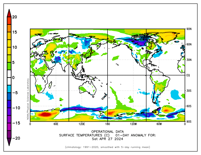
The Arctic Oscillation is forecast to turn negative again, hinting at cooler weather in the Northern Hemisphere starting in about a week.

Much of Russia, Siberia and the former Soviet Republics are already seeing well below normal temperatures, but this is (of course) not being reported by the press.

http://www.esrl.noaa.gov/psd/map/ANIM/sfctmpmer_01a.fnl.30.gif
Ralph,
He is using the Ellis scale which ranges from catastrophic thru disastrous via not good, bad, extremely bad and much worse.
(Yep, he managed all of those in one post. Clever chap)
Otter,
You don’t need to go back half a billion years – 6/7 thousand will do it!
http://www.ngu.no/en-gb/Aktuelt/2008/Less-ice-in-the-Arctic-Ocean-6000-7000-years-ago/
Sorry, your bus has left the station.
Now that this year’s brief “window of opportunity” for solar radiation to defrost the Arctic Ocean is closing fast we can see that it hasn’t amounted to very much at all. Early on in the period of (relatively) high solar angle, short atmospheric obstruction path and long polar days there appeared to be the inception of a significant departure toward more absorptive open water and less high-albedo sea ice. (According to the crude “ice extent” graphs we are given). However, midway through the season the ratio shifted back into the decade-long fold and no new trend was established. The complexities of that ever-shifting triple intersection of ice, water and air remain “equivocal” and “unsettled”.
Mr Ellis also managed “decline” but I missed it the first time as it was hidden in the middle of the paragraph.
stevengoddard says:
August 1, 2010 at 1:49 pm
Good time for Lewis Pugh to take off in his kayak towards the North Pole.
These days it appears he’s hung up his oars and now dons a pair of speedos for extreme-cold water swim stunts, such as in a glacial lake beneath Mt. Everest.
His motto is “time to believe”. At least he’s upfront about it. Nothing to do with science, just Belief.
stevengoddard says:
August 1, 2010 at 1:48 pm
Stephen Pruett
PIOMAS gives the answer which warmists want to hear, so they make up justifications for that idea.
***
?
Thrasher says:
August 1, 2010 at 2:02 pm
***
Extent, extent,extent…..ice volume anyone?
rbateman says:
August 1, 2010 at 4:44 pm
Gail Combs says:
August 1, 2010 at 3:01 pm
So where did the super cold in South America go???
Apparently, according to the Short Term Climate at NCEP:
http://wxmaps.org/pix/temp8.html
It’s still there, and it’s predicted to hang around.
If it is a preview of the N. Hemispere’s winter, it’s going to get ugly.
________________________________________________________________
I am glad I moved from New Hampshire to North Carolina.
Then how come the cold in S. America does not show on these maps or am I missing something?
This is the hi-res Modis temperature map for July 29th
http://neo.sci.gsfc.nasa.gov/RenderData?si=1508381&cs=rgb&format=JPEG
This is the week of July 20th to July 27th.
http://neo.sci.gsfc.nasa.gov/RenderData?si=1508290&cs=rgb&format=JPEG
Douglas DC says:
August 1, 2010 at 2:04 pm
Perma frost does not burn, Tundra does Ask any one who’s fought wildland fire in Alaska-I have…
***
It is burning in Siberia right now. Think melt, sun, heat, dry, …lightning. If interested you can see it on satelite images.
Damn, guys, I just want to play poker with a bunch of Warmistas. That’s a large part of my income, and these guys have tells that any fool can see from a mile away.
Peter Ellis says:
August 1, 2010 at 3:53 pm
=====
Nice summation.
Now we watch and learn.
Why do the Warmistas (Calamitologists) never look south? Maybe they don’t want to see what’s sneaking up behind them? Boo!
Amino Acids in Meteorites says:
August 1, 2010 at 4:57 pm
It looks like PIOMAS shows the M’Clure Strait (or McClure) as open. But Cryosphere Today does not show that it’s open.
M’Clure Strait
http://img829.imageshack.us/img829/7357/arctic.gif
Cryosphere Today, 7/31/10
http://img713.imageshack.us/img713/9458/arcticseaicecolor000d.png
___________________________________________________________________
Great pictures. It looks like Ellesmere Island is covered in snow (ice?) which is interesting. Given the following tidbit:
Abstract
“In 1875, members of the British Arctic Expedition under the command of George S. Nares discovered two ancient-looking stone cairns on Washington Irving Island at the entrance to Dobbin Bay, eastern Ellesmere Island, Nunavut, Canada. At least one of these cairns was destroyed by the expedition members to construct their own cairn. The possibility that these cairns were built by Norse voyagers to Kane Basin is supported by the large number of Norse artifacts recovered from Thule culture Inuit sites in the Bache Peninsula region just south of Washington Irving Island. Surveys of the island have identified scattered boulders marking the location of the cairns, but the question of the builders’ identity still remains a mystery.”
Makes you wonder what else might be buried under the ice.
Regarding the comment by:
“Peter Ellis says:
August 1, 2010 at 3:53 pm”
and concerning the statement:
“…Whether 2010 follows the former pattern or the latter determines whether this year’s ice loss will be disastrous, or merely extremely bad.”
I found your use of the words “disastrous” and “merely extremely bad” a bit subjective.
Let me take you back, if I may, to the year 1200, in the northern of the two main Viking settlements on the west coast of Greenland. They had roughly 1000 cows and roughly 100,000 sheep and goats. At this time of year they were frantically gathering hay, during the short summer, to keep all these cows, sheep and goats alive during the very long and cold winters.
If the summer of 1200 had been as “warm” as this past summer was, they could not have gathered enough hay to feed 1000 cows and 100,000 sheep and goats. You see, everything is relative. What you call “warm” they would have cursed as “cold.”
They would not have called this summer “merely extremely bad.” They would have called it “disastrous.”
If it warms enough to raise 1000 cows and 100,000 sheep and goats in that part of Greenland again, will it be a disaster?
Love your globe projections, Steve!
Ok, as most knowledgeable readers understand, the elevated heat experienced has come from the oceans. What will be of most interest to me is the OHC data in the next 12-18 months.
It appears the oceans have released a substantial amount of heat, so where does that put us in 6 months? I’ll hazard to say the majority of the NH will be seeing anomalously cold temps, if not even exceeding that of 1999.
Gail Combs says:
August 1, 2010 at 6:14 pm
The swaths on the July 29th Modis map are not calibrated to each other, but to themselves.
That much is obvious.
Some ice extent numbers from the last 4 years from NSIDC’s daily extent fields:
July 31st 2010: 6.88 million sq-km
July 31st 2009: 7.12
July 31st 2008: 7.56
July 31st 2007: 6.69
average for 1979-2000: 8.61
not sure how that makes 2010 a recovery in some folks eyes, to me it looks like ice melt in 2010 is like it has been the last few years.
Julienne,
It is too bad that NSIDC graphs don’t show other years, but from the DMI graph it is pretty clear that that all recent years are tightly grouped until the second week in August. July 31st extent does tell us much.
http://ocean.dmi.dk/arctic/icecover.uk.php
Doesn’t minimum extent only matter Julienne? That’s what everyone said back in April when 2010 had the big spike…and they said it back in 2008 when it was doing well until the big August melt. So why should 2008 matter on that list when we know it’s probably going to fall below 2010?
I don’t understand all these double standards? If 2010 ends up at a higher min than 2009, is everyone going to say “well for most of the summer is was below it, so it doesn’t count”? What if this -PDO cycle and incoming -AMO cycle (lagging the PDO cycle) cools the arctic and we start seeing an increase in extent that continues since 2007…is that just going to be “cycles” and not “climate”? I’m pretty dumbfounded at all the cherry picking that goes on. It happens on both sides. Not just the AWG side as this site sometimes claims.
I’ve been quite turned off by the the fact that none of the official agencies (such as the NSIDC) have even mentioned such fairly rudimentary climate cycles such as the PDO/AMO in any of their discussions. Maybe they did once but I didn’t notice. However, from the general context of their discussions it sounds like the arctic sea ice will never rebound at all…it sounded like that in 2008 and still sounds like that now.
It reeks of a fairly close minded mentality that climate is in a “Death spiral” and ignores that maybe climate actually goes in cycles whether there is an underlying human contribution or not. At any rate, hopefully these agencies will start researching more into actual climate cycles rather than just promoting this death spiral garbage…we heard it in 2007 and all we’ve gotten is an increase in ice every year since. It would be nice to get back to the actual science.
Thrasher
Please remember that Julienne has forecast the identical summer minimum as myself.
DirkH
Thanks. It is much easier to visualize the earth in equal area 3D projections.
Hey Steve … I’m a tad late to the party, but hopefully you’ll read this.
I have a publishable idea for you. I notice on the cryosphere “tale of the tape” the anomoly of arctic ice over the year. … idea … it would be nice to see and compare the area under the curve of anomoly from year to year to see if their is a metric. It’s obvious that the area for 2007 would be the largest. By the eyeball, it looks as if 2008 would be next, followed by 2009. [ based purely on the eyeball of anomoly line under [or over] the 1 million mark. IF .. 2010 spikes up above -1 million rather rapidly, it would produce what looks to be a nice trend that can be detected, even though the maximum anomoly of 2008-2010 look to be similar.
Do you have any data looking at yearly area under the curve for the arctic melt??
Steven Goddard,
I do remember that, but their posts have been quite skewed toward how low the ice is right now and I was just pointing out the bias in perception of a lot of people’s posts. I actually think the min might be a bit lower then 5.5 mil sq km, but I think that forecast isn’t that bad.
I just think the perception of the articles and posts made by a lot of these agencies always points to how low things are and always attributes that to a “Death spiral” or a continuous decline rather than pointing out some other multi-decadal factors that might be significant. I was merely trying to open up a little debate on that subject, though maybe I came across as too critical. I apologize if that was the case.
I do hope that the DMI is excluding the erroneous
station right next to the pole which has read -26C all summer long:
http://www.uni-koeln.de/math-nat-fak/geomet/meteo/winfos/synNNWWarctis.gif