When I got this press release from NOAA a few minutes ago, the first thing I did was check the NOAA NESDIS sea surface temperature map for the tell-tale El Niño pattern signature, because NOAA didn’t include any SST graphic in the press release. I sure don’t see an El Niño pattern in today’s SST product. Now, compare today’s product to the one from August 27th, 2009, when there actually was an El Niño, something they reference in the press release.
 Source: http://www.ospo.noaa.gov/data/sst/anomaly/2009/anomnight.8.27.2009.gif
Seems like a reach to me, especially when the report referenced in the PR says:
Overall, these features are consistent with borderline, weak El Niño conditions.
Update: Confusion anyone? AP’s Seth Borenstein got this quote from the NOAA staffer quoted in the PR and tweeted it:
@afreedma Halpert acknowledges: "What we've learned from this event is that our definition is very confusing and we need to work on it."
— @borenbears (@borenbears) March 5, 2015
Update2: It seems there is a decision flowchart for calling an El Niño, I wonder if they followed it this time?

Source: http://www.climate.gov/news-features/blogs/enso/decembers-enso-update-close-no-cigar
Here’s the PR:
 NOAA: Elusive El Niño arrives

Forecasters predict it will stay weak, have little influence on weather
and climate
Contact
Maureen O’Leary, maureen.oleary@noaa.gov, 202-578-5257
March 5, 2015
The long-anticipated El Niño has finally arrived, according to forecasters with NOAA’s Climate Prediction Center. In their updated monthly outlook released today, forecasters issued an El Niño Advisory to declare the arrival of the ocean-atmospheric phenomenon marked by warmer-than-average sea surface temperatures in the central Pacific Ocean near the equator.
Due to the weak strength of the El Niño, widespread or significant global weather pattern impacts are not anticipated. However, certain impacts often associated with El Niño may appear this spring in parts of the Northern Hemisphere, such as wetter-than-normal conditions along the U.S. Gulf Coast.
“Based on the persistent observations of above-average sea surface temperatures across the western and central equatorial Pacific Ocean and consistent pattern of sea level pressure, we can now say that El Niño is here,” said Mike Halpert, deputy director, NOAA’s Climate Prediction Center, and ENSO forecaster. “Many climate prediction models show this weak El Niño continuing into summer.”
Forecasters say it is likely (50 to 60 percent chance) that El Niño conditions will continue through the summer.
The last El Niño, in 2009-2010, was a moderate to strong event. Other recent El Niño’s took place from 2002-2003 (moderate), 2004-2005 (weak), 2006-2007 (weak to moderate). The last very strong El Nino was 1997-1998 and was known for providing heavy rainfall in the West, especially California. As for this year, “this El Nino is likely too late and too weak to provide much relief for drought-stricken California,” added Halpert.
NOAA scientists will continue to monitor the situation and will issue its next monthly update on April 9.
![]()
NOAA’s mission is to understand and predict changes in the Earth’s environment, from the depths of the ocean to the surface of the sun, and to conserve and manage our coastal and marine resources. Join us on Twitter, Facebook, Instagram and our other social media channels. Visit our news release archive.
http://phys.org/news/2015-03-el-nino-weak-weird-late.html
I agree with Prof Allen Clark at Florida State, after a year they had to call it. Just like the solar magnetic reversal, they finally had to call it. No wonder I disbelieve the Higgs claim, after the hype they had to call it. And its useful because if they do actually find something, there is the priority claim.
Yup. With you on the Higgs too.
Same here.
What do you mean re: Higgs? I thought it was found – over and done at mass 125. Are you saying “calling it” is the same as making it up?
They are having a niño?!?! These people should not be allowed to reproduce!! I am afraid it will be a miscarriage this time
Well I’m not a weather / climate guru or geek, but I always thought that “El Nino” originated off the coast of Peru, when all the rookery birds starved, along with the coastal fishing communities, because the bait fishes took off for cooler waters.
So Aug 2009 looks classic to me (what the hell do I know) but today ??
I’d say nyet on el Nino this morning.
g
They are changing the definitions George. It is what they always do.
According to the WHO (Geneva 1999) document “El Niño and Health” http://www.who.int/globalchange/publications/en/elnino.pdf it is stated, “There are differences between climatologists in the definition of El Niño and in the designation of individual events. For example, some researchers have suggested that the 1991 El Niño spanned three calendar years 1991–3, others have suggested it continued into 1995 (Glantz 1996a). The definition of La Niña is even less clear, partly because there have been fewer events.” … “As there are no universally agreed criteria for an El Niño (or La Niña) event there is some disagreement between climatologists whether some weak events should be “counted”.”
Does this still apply or have new definitions supplanted those of 1999?
The climate ‘scientists’ have tuned what they want their models to show about ‘El Nino’ in the warm PDO. It recently changed after about 60 years to a cold PDO. All their model tuning and clever boxes and atmospheric pressure gradients etc etc are set up for the warm PDO.
Now their models don’t work.
It will take them some time to change the models and the clever clock face dials and temperature boxes etc etc. That is if they accept that they are wrong. From previous experience of their behavior they are more likely to carry on making nonsensical claims and massage the data to fit what they are saying.
George – it’s slipped from Peru to Chile.
Lots of confusion among the would-be experts and yes they keep changing the definition of El Nino and so the confusion predominates.
The term El Nino referred originally to the Christmas season, from Peru (El Nino = boy child = Christ child). This euphemism referred to the seasonal fluctuations of upwelling offshore
S. America, upon which the fishing industry depended (the greatest fishery on the earth, in tons of catch).
Now, none of the self-appointed experts can tell you what an El Nino is nor why they occur.
They are due to the fluctuations of upwelling (See Humboldt Current) off that coast.
By the way, Peru recently put a restriction on fishing because of the faltering of the upwelling.
I should add that the upwelling, or fluctuations thereof, has nothing to do with CO2, but how the alarmists love it when there is a temperature rise due to El Nino. Screeches galore!
The minx! She must be dealt with most severely!
El NoNo?
La Nada.
El Ninito
🙂
Elle Neenyo
El Nee-naw, Nee-naw – call the waaambulance, it’s another bust for the warmies!
El ninito, mas o menos
Limp Nino
Q: El Nino?
A: ‘Ell No!
God: “El neener neener neennerrr”
I defer to the higher authority!
Apparently they are following Dr Mann’s lead by redefining what an El Nino is to declare this an El Nino (“Based on the persistent observations of above-average sea surface temperatures across the western and central equatorial Pacific Ocean and consistent pattern of sea level pressure”). As far as I recall that is not a definition of an El Nino. True the 3.4 area is in El Nino range (barely), but it was that way in the fall and NOAA did not declare an El Nino. Also I don’t think the Trade Winds are exhibiting behavior consistent with an El Nino either.
My geographic skills must be lacking because it doesn’t look to me like there are ‘persistent’ above-average sea surface temperatures in the western equatorial Pacific. Maybe I don’t understand where that is exactly (the 2009 graph appears to show above average sea surface temps in the Western Equatorial Pacific tho)?
My guess would be that the ‘weak’ El Nino drops back to neutral in a few weeks, I highly doubt the 50-60% ‘prediction’.
So I don’t figure just where the Western Pacific gets into PeruChile fishing foibles ?! Maybe they mean Philipine Phishing Phoibles.
DC, not only is the West Pacific pool cool, as per the SST map above, but it is also a hole.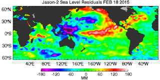
IIRC from Bob, El Nino’s are hot water flowing from the west to east. Not only is the water cool, but is now going to flow up a 200 mm hill.
Sounds a bit like the Southern Oscillation Index used by BoM.
Well we already knew boringstein would be confused…..
Warmer than normal water is now moving in through the equatorial under-current. Unlike last year, there is much less cool water in the eastern pacific to cool it off / moderate it. Probably heading toward an El Nino this year but lots can still change.
I await with baited breath Bill and i hope it comes off so we can move into the next La Nina at strength.
But i fear it will dissipate as it did last year and be another neutral, unless this next WWB can then start the wheels in motion for colder water to start to follow the warm pool westwards in the coming months.
At this current rate the warm sub surface still looks well out in timing, will be all over by August.
Here in Oz the weather def has been behaving like the 2009-2010 El nino, lots of humidity and troughiness.
My question is: “Did someone put some questionable chemicals in their morning coffee before they sat down to write this PR?”
It’s quite obvious there’s an El Nino on the map. However, due to global warming, it has been moved north a bit, up around the Baja. Or, is that it up around Seattle… Maybe both?
Oh, Mr. Crawford, come one. What is obvious is you did not read the flow chart above… (or much else about ENSO).
Hm. I just wonder what operates “up around Seattle.”
Please see this comment for links to two WUWT posts with much helpful info.:
http://wattsupwiththat.com/2015/03/05/noaa-claims-elusive-el-nino-arrives-the-question-is-where/#comment-1875829
I mean, “Come ON!
lolololo
Ha! Thanks for the good laugh. PS: You forgot you sarcasm tag.
Well, Tim, I certainly hope so… . Good for you to give Mr. C. the benefit of the doubt. I took him for a troll (just that perfect combination of ignorance, feeble-mindedness, and over-confidence).
Janice, you lovely woman, he was pulling your skirt§ Lol
Monsieur Richards! YOU have been in Paris too long… 😉
(but, (blush)
merci… you watered a very parched flower).
Yes, indeed, Joe Crawford’s dry humor was a brilliant imitation of a troll.
And… I’m wearing Levi’s… if anyone tugs on them….. I’ll….. oooooh…… I’ll YELL AT HIM, “KNOCK — IT — OFF!… then, let my German Shepherds bite him, heh, heh.
@janice, will the first shepherd leave enough for your second one? or do they “share” (found work? good luck btw )
It is well known that man-made global warming changes geography. And cartography. And stenography. And….
and pornography!
The El Nino is hidden deep below the surface.
El Niño????
Where and when?
I guess: The answer my friend, is blowing in the wind…..
Niño arrives’ – the question is, ‘where’?
In Australia when someone needs to achieve the impossible we say “You will need to pull that out of your a####”
Or….
“Tell him he’s dreaming”.
It has been a different set of events. Back in August the 3.4 region went below threshold (.5) which was the big reason for no El Nino call last fall. However, at the time the 1-2 region was quite warm and fit the El Nino pattern much closer.
Overall satellite data showed added warmth in the tropics consistent with an El Nino. Now, the latest satellite data (Feb) shows the tropics being much cooler even as the 3.4 region has warmed.
I can see why they are confused. This year has made it very clear that we only have a poor understanding of the El Nino phenomena. Any predictions are pretty much useless at this time.
“I can see why they are confused.”
Fine, but why change the definition? It’s the same thing with making adjustments to historical temperature records based on different methodologies, etc. and making new adjustments to bring things into an alignment via proxies.
There is a reason anything electrical must conform to USP standards, why there is a NIST agency, why computers follow(ed) standardization – to keep things uniform. When an agency like NOAA decides that the historical definition of an El Niño is inadequate to confirm or deny, will they now go back in time to look at the historical record and make adjustments to the frequency of El Niño in years past? Honestly, it’s providing no usefulness going forward other than to promote an environment where their operating budgets are maintained or increased.
Yeah, but that is the whole purpose of the climate change meme – Increase government power and budgets!
Yes, the N Pacific is in an odd pattern. Warm water in the northeast Pacific off N America, but the core area of El Nino off equatorial S America is avg or slightly below average. And a warm spot along the equator in the mid-Pacific.
Lately the warm NE Pacific area seems to have been “pushed” eastward and bifurcated a bit — north to southern Alaska and southwest toward Hawaii. The ITCZ area off S America, that will show significant convection during an El Nino, shows almost no activity right now. So the typical westward winds off equatorial S America seem to be blowing as usual.
The warm water off southwest California is providing the southwest US w/some precip, but not much.
Is this all the “missing” heat that the Pacific can belch up?
Well, the BBC reckoned the “scorching El Nino” might be responsible for wrecking England’s chances in last summer’s Football World Cup.
http://www.bbc.co.uk/news/science-environment-27343057
England are now doing badly in the Cricket World Cup, so, by BBC logic, I reckon that must be prima facie evidence of a continuing El Nino. Some where.
I’d like to hear from someone who is well-informed about the PDO…
Looks to me like THAT is what is shifting into “warm” gear.
Some background:
1. “The Pause that Cools: No More Warming Until 2015?
{nice call, there Anthony … as it is appearing….!}
http://wattsupwiththat.com/2008/04/30/a-look-at-hadcrut-global-temps-and-pdo-with-hodrick-prescott-filtering-applied/
2. 2014/15 — Part 5 — The Relationship Between the PDO and ENSO
by Bob Tisdale
“A strong positive PDO index value indicates the sea surface temperature anomalies of the eastern extratropical North Pacific are warmer than the western and central portions,… .”
http://wattsupwiththat.com/2014/04/21/the-201415-el-nino-part-5-the-relationship-between-the-pdo-and-enso/
Well! I found Mike Maguire (well-informed about PDO meteorologist) addressed PDO:
*** The PDO in the last year has spike positive(+PDO).
Either we are prematurely switching back to a +PDO regime(10-15 years early) with the possibility of a pattern change which will favor milder Winters again or the +PDO spike higher will be short lived, similar to the late 1950’s, in the middle of the previous -PDO regime, when the +PDO only lasted briefly and was followed by another 15 years back to a -PDO, along with more modest global cooling(until that ended in the late 1970’s).
http://research.jisao.washington.edu/pdo/PDO.latest
http://research.jisao.washington.edu/pdo/
Maguire 10:10am, 3/5/15 comment here: http://wattsupwiththat.com/2015/03/05/state-of-the-sea-ice-february-2015/#comment-1875936
Thank you, Mister Weatherman 🙂
They’re still hedging a bit by saying El Niño conditions, not El Niño event.
From the NOAA site: http://www.cpc.ncep.noaa.gov/products/analysis_monitoring/lanina/enso_evolution-status-fcsts-web.pdf
could these enigmatic conditions be the result of the global oscillations no longer being phase-locked?
http://i60.tinypic.com/6z0tvo.jpg
Oh, man, Dawtgomis — GREAT graphic. LOL, what a bunch of clowns.
IPCC: “Well, …. uuuuuh….. they sometimes were and …. they sometimes weren’t in phase and ……. duh…….. sometimes they ….. aaaaaaaaaa YOU KNOW WE ARE RIGHT: 97% of scientists agree!!!.”
What any genuine scientist at NOAA will now be wearing to work:
http://ts1.mm.bing.net/th?&id=HN.608053810662016189&w=300&h=300&c=0&pid=1.9&rs=0&p=0
Truly appropriate headwear for anyone on the govt. payroll, that’s for sure. I just thought maybe I was on to something in my absent minded prof-hoosier way.
We ought to photoshop a tassel onto that graduation cap!
@ur momisugly Dawtgomis — lol. GREAT idea. #(:))
(thanks for acknowledging my photo)
@janice, now I know where all the brown paper bags in the grocery stores went, thanks the tassel is a great Idea (Donkeys tails?)
There is an El Nino because they say there is, ok ?
🙂
Guess they must have had something in the water or what?
March 3 ’15 Multivariate ENSO Index (MEI):
http://www.oarval.org/ts3Mar2015Opt.gif
See ESRL-PSD: Multivariate ENSO Index (March 3 ’15, Klaus Wolter, NOAA), at http://www.esrl.noaa.gov/psd/enso/mei/
There is an approximately 50-60% chance that El Niño conditions will continue through Northern Hemisphere summer 2015.
See http://www.cpc.ncep.noaa.gov/products/analysis_monitoring/enso_disc_mar2015/ensodisc.html
From 1976 to 1998, any prediction of an El Nino might have been easier simply because the El Ninos were typically so much stronger in that period. Now we’re in a cooling PDO, El Ninos are likely to be weaker and perhaps less frequent and perhaps much harder to predict???
El Nino. Beginning in March?
With the posting of the Dec-Jan-Feb ONI number, there have now been 4 readings of 0.5 or greater. The rule was that 5 readings above 0.5 were required before an El Nino call, so they must believe Nino3.4 will be warm in March.
http://www.cpc.ncep.noaa.gov/products/analysis_monitoring/ensostuff/ensoyears.shtml
they must believe Nino3.4 will be warm in March.
=======
ve haf veys to make it varm.
Was looking at the unusual levels of warmer than normal water around the W and SW Pacific yesterday, lots of it:
http://earth.nullschool.net/#current/ocean/surface/currents/overlay=sea_surface_temp_anomaly/orthographic=-214.12,-21.73,748
I checked it because a worrying system has been consistently shown to form and come toward next week. Fairly big, symmetric, lots of humidity, plently of warm water. It’s just a bit cooler where Marcia’s tracked to coast:
http://earth.nullschool.net/#2015/03/10/0600Z/wind/surface/level/orthographic=-214.12,-21.73,748
The wet-season has been a bit of a non-event in QLD due to mid and upper level southerly air intrusions through the continent’s center reducing interior humidity level so we have had almost only to coastal margin rainfall in the East and dry heat in the interior. So drought does appear likely to deepen this year.
Other than that, SSTA show no El Niño apparent, there’ way too much warm water still, and just southerly continental air that’s spoiling the humidity levels for a decent wet dump, the chances of which are rapidly fading now … except for the projected westward moving storm next week.
Our rain has seemed like a weak El Niño year here in So Cal.
Quite an ample rainfall though in the desert southwest this fall and winter season and into West Texas.
Compare January 2015 to January 2014.
http://www1.ncdc.noaa.gov/pub/data/cmb/sotc/drought/2015/01/zin-201501.gif
http://www1.ncdc.noaa.gov/pub/data/cmb/sotc/drought/2014/01/zin-201401.gif
And looking ahead, here is what the NOAA CPC thinks:
….rolling the chicken bones, viola!!
http://www.cpc.noaa.gov/products/predictions/30day/off15_prcp.gif
That’s what I mean. We’ve been getting regular little showers, which is unusual. No deluge, but definitely wetter than average.
“NOAA’s mission is to understand and predict changes in the Earth’s environment, from the depths of the ocean to the surface of the sun…”
Why do the stop at the surface of the sun? Why not go deep into the sun? Or right out to the edge of the solar system, or to the edge of the event horizon? All that is in the Earth’s environment if you’re going to define it so broadly. Are they really understanding and predicting what’s going to happen on the surface of the sun? Or even of Venus? They can’t even predict the bottom of the atmosphere correctly so I do wonder why they’re worried about stuff millions of miles away.
That’s because no one can yet rule out the interplay of cosmic radiation and heliospheric conditions with Earth’s climate. The NOAA is correct to pursue an ‘all-inclusive’ perspective to research. There are assuredly staff members who also have asked “Why not go deep into the sun?, how can we devise a method?” That would be the best way to understand and predict potentially civilization-disrupting coronal mass ejections.
To not be a “Flat-Earth Society” we must set our perspectives on the totality of the environment that our relatively tiny planet journeys through.
“This is the first El Nino since spring of 2010.”
The 09-10 El Nino was followed by a back to back double La Nina’s (10-11, 11-12) in which more than compensated for the El Nino -’10 bump-up in temp anomalies.
This weak Little Boy one will almost certainly be followed by a Little Girl this fall or next winter.
Light up the cigars.
Yes, and 2011 was a record snow year for the Sierras, despite the La Nina.