With an atmospheric river dumping trillions of gallons precipitation on California and other western states, some news outlets have asked how the precipitation might affect Lake Mead, suggesting that the rainfall will do little for the lake or the Colorado River basin which feeds it because it’s drying out due to climate change. Although it is true that the current storm will likely do little to reverse Lake Mead’s decline in the long-term, the reason for its decline is not climate change, but instead, overuse and poor management of the reservoir.
A number of mainstream media outlets ran stories in recent days remarking on the fact that the recent atmospheric river event is dumping more water in a few days than Lake Mead, America’s largest reservoir by volume, can hold at full capacity. On February 7, for example, Newsweek, ran two stories on the heavy rains, “Bomb Cyclone To Dump More Water Than in Lake Mead on California,” and “Atmospheric Rivers Won’t Refill Lakes Mead and Powell, says expert.”
These two stories were largely straight forward reporting, the kind of honest journalism Americans used to expect from the media outlets. Newsweek did not attribute the present atmospheric river or Lake’s Mead or Powell present water levels to climate change.
Also, Lake Mead’s water levels are dominated, not by a single rainfall event, affecting areas primarily downstream of the reservoir, but by seasonal snowpack across the course of the winter which, when it melts over time, flows into the lake, its feeder streams, and Lake Powell above it, which is the primary source of stream flow feeding Lake Mead. Last season’s record snowfall on mountains of the Colorado River Basin boosted lake levels.
Courthouse News and the Missoula Current each ran stories covering a trial in which climate activists are suing U.S. Department of the Interior for setting a management plan that fails to account for the impacts of climate change, which they claim is causing lake and river levels to fall.
As detailed at Climate Realism, here, here, here, and here, for example, this is not the first time climate activists, often with the support of the mainstream media, have falsely claimed climate change has caused a precipitation decline in the Western United States, which they blame for recent declines in Lake Mead, the Great Salt Lake, and Lake Tahoe. Mismanagement is part of the story of the decline in some Western rivers, reservoirs, and lakes, but there is no evidence long-term climate change is contributing to the decline. Myriad other factors are, though.
As Newsweek reports, Lake Mead did reach its lowest measured water levels since filling in history in 2022, but it had similar low-level seasons in from 1955-1957 and again in 1964 and 1965, nearly 70 and 60 years of global warming ago, respectively, when temperatures were cooler.
The U.S. Drought Monitor reports that under 35 percent of the Colorado river basin, touching on seven states and parts of northern Mexico, is currently suffering any drought, and only approximately 3 percent of the area is suffering extreme or exceptional drought. A review of the history shows that record lake levels were recorded between 1965 and 1983, with Lake Mead remaining consistently above average through 2002, a representing a 37-year period of sustained above average water levels, even as temperatures were rising. As is noted in Climate at a Glance: Water Levels – Lake Mead, after 37 years of abundance, some decline was bound to eventually occur.
Since then, the Colorado River Basin has on average experienced below average precipitation, but it is in the arid West so that is to be expected. The U.S. drought monitor shows some years with severe, widespread drought for extended periods of time, and some years in which less than 10 percent of the basin was experiencing any drought at all. Regardless there is no clear trend of droughts of increasing intensity that would suggest climate change was causing a sustained decline in precipitation across the basin.
Since climate change can’t be shown to be contributing to Lake Mead’s decline, we must examine other factors which might, and there are many. The National Park Service (NPS) discusses two factors contributing to Lake Mead’s decline that are entirely ignored by climate alarmists: sedimentation and evaporation. Concerning evaporation, the NPS writes, “[e]vaporation in the area is extremely high and represents a significant water loss [equaling] … almost 10% of the average annual inflow.”
In addition, the NPS cites research which suggests that by 1970 the build up of sediment behind the Hoover Dam had already robbed Lake Mead of approximately 12 percent of its volume. Some of that sediment has likely compacted since then, but over the 54 years since that study study was done sediment has continued to flow into Lake Mead and accumulated, so its volume had undoubtedly shrunk even more. Sustained dredging operations would both increase Lake Mead’s volume and provide valuable, fertile soil for those who might want it.
The most important single factor in Lake Mead’s decline, however, is the tremendous growth in population for the region. Arizona and Nevada are two of the fastest growing states in the United States. The number of agricultural, urban, and industrial users of water from Lake Mead and its feeder rivers has grown tremendously in the past 30 years. More people farming in, living in and building homes, golf courses, businesses, in Arizona, California, Nevada, and Mexico, means more demand for water from Lake Mead, whether or not precipitation in the basin has declined. Since 1993:
- Arizona’s population increased by approximately 3.44 million people;
- Nevada has added about 1.81 million people;
- And, California saw its population grow by about 7.82 million people.
Ever more people drawing water from the limited and variable resource that is Lake Mead, would naturally result in declining lake levels, unless the stream flow into it were dramatically increased. The latter is precluded by the fact that other states that draw water from the Colorado River, and other tributary rivers in the Colorado River Basin, have also experienced dramatic population growth, meaning there is less water flowing into Lake Mead simply because more people are taking more water out of its tributaries for more uses upstream. The largest source of water for Lake Mead is outflow from Lake Powell, yet Lake Powell is also oversubscribed and has the same problems with sedimentation and evaporation that Lake Mead does, limiting the water sent downstream to Lake Mead. Less flow in, more water withdrawn is a recipe for declining water levels.
And that’s not even counting the increase in water demand from Mexico.
Both California and the Federal government basically acknowledged in December 2023 that over withdrawal is the prime cause of Lake Mead’s declining fortunes. As reported by Fox News, “water districts representing California farmers and other major water users in the state agreed to significant cuts in exchange for hundreds of millions of dollars from the federal government.” The government estimates that this agreement by itself will result in Lake Mead rising at least 10 feet. Similar agreements with Arizona, Nevada, and Mexico would be expected to increase Lake Mead’s volume even more.
In short, myriad factors have resulted in Lake Mead’s substantial water loss. Climate Change is not among them.

H. Sterling Burnett, Ph.D., is the Director of the Arthur B. Robinson Center on Climate and Environmental Policy and the managing editor of Environment & Climate News. In addition to directing The Heartland Institute’s Arthur B. Robinson Center on Climate and Environmental Policy, Burett puts Environment & Climate News together, is the editor of Heartland’s Climate Change Weekly email, and the host of the Environment & Climate News Podcast.
I also looked up aggregate water use in Arizona in the 1960s vs today. Although MANY, MANY more people live in Arizona now than sixty years ago, aggregate water use is about the same. There are probably several reasons for this: less industry and agriculture, changes in how agriculture uses water, increased efficiency of water use in cooling towers, xeriscape landscaping. While this is only one state, I gotta figure that the other state also have similar situations.
I read an article a couple of years ago that the ACE and other members of the federal alphabet soup changed the recommendations on when to release waters from dams, lowering the maximum level of most reservoirs to a fraction of the actual capacity. The result is that reservoirs in the West stay at very low levels. It was actually an article by a Gang Green group, so I got figure that they would have a stake in encouraging the “reservoirs are in bad shape because of climate change” story.
It’s extremely difficult to find it now — is been a few years. But I will try.
Per USGS data tracking consumptive water use in the Colorado Basin going back to 1985, and as you wrote, it has been relatively flat, while population has increased rapidly. Agriculture has maintained a consistent 85% of total consumptive use.
The principle reason for flat consumptive use is water conservation measures. Irrigation use has been highly refined over the decades due to the limited resource. Domestic appliances have been driven to be much more conservative of the resource. For instance, toilets that 60 years ago used approx. 5+ gal per flush are now using less than half a gal/flush. Front loading clothes washers use much less water than the older top loading models. Shower heads and faucets have also been designed to use much less water than their predecessors.
Another facet of water conservation is the widespread use today in urban and suburban areas of water reuse – taking treated sanitary waste water, applying additional treatment to reduce pollution, and distributing it for use as landscape irrigation water in a separate distribution system. Since most domestic water users live in urban and suburban areas, this has a very large effect on water consumption. The typical suburban home without recycle water will use approx. 70-80% of water use on lawn, shrub, and tree irrigation.
Isn’t there now a push for homes to give up lawns and non native woody vegetation and do desert landscaping?
Here is plot of lake Mead level over the past years FYI.
https://mead.uslakes.info/Level/
There appears to be a major shift in rainfall /snow pattern. It started in the spring of 2022 with yellowstone flooding. Then the winter of 2022/2023.
This winter is down some, but it is not over yet.
Recent reports of snowpack in the Colorado River drainage division show it to be average for this time of the season. If Lake Mead levels start to drop below average again, then you’ll know it has little to do with climate or climate change.
https://www.nrcs.usda.gov/wps/portal/wcc/home/quicklinks/states/colorado/
Jim Steel had a piece on here last year showing how there is no long term trend on inflows to lake Meade, it’s a sine wave
What is different is outflows, increasing every year.
Still blows me away that you can fly into Vegas and see thousands of backyard pools? It’s been 6 years but I don’t imagine it’s changed, same with phoenix.
Someday we will build another KXL from canada but to the SW and will get rich pumping water south.
Sedimentation should contribute to a loss of volume and an increase in surface level height.
The surface level height is governed by policy and the physical height of the dam. Sedimentation can’t raise either.
Assuming that the water stays below the dam height, sedimentation wouldn’t have anything to do with volume. If the lake bed rose slightly, the the surface of the lake would rise in kind, and the volume would remain unchanged.
I don’t know why people down voted this, you are absolutely right. Take bowl and put X volume of water in it, chuck in some stones and unless the water overflows the bowl you still have X volume of water. Sedimentation can reduce the volume of the reservoir but not the volume of water in it unless it overflows.
Three down votes, eh? Try this then: fill a 12 ounce cup with six ounces of water. Now add sand, rocks, marbles, whatever. Is the total water volume still the same? Did the sand/rocks/marbles do a matter-antimatter reaction and cause the water to annihilate and vanish? [cue Jeopardy music]
When one checks the lake levels of Lakes Mojave and Havasu down stream, both ignored by the MSM, neither seemed to suffer from “Climate Change” as the images of Lakes Powell and Mead were both plastered on the news with the implication that the entire Colorado Basin was empty.
They should put thermometers around Lake Mead if they are going to claim that warming is causing its level to rise. On Earth, different places warm up and cool down at different times.
It is complicated.
The atmospheric rivers dumping on CA do not necessarily reach across the Sierra into the Colorado river basin watershed. And Ca has foolishly not added any water reservoir storage since decades.
The original Colorado River compact was concluded during a historic ‘wet’ time, so arguably invalid long term.
The regions population growth since has since severely taxed the Colorado River basin watershed. A simple lesson—don’t grow a desert population in Las Vegas.
As a wet south Floridian, I say they made their mess, let them fix their mess. I want no part of it. We got our own problems with Burmese pythons in the Everglades.
Why aren’t all dams built with a drain gate at the base so that periodically they can be opened to flush out silt? Makes me wonder how much gold is packed up at the base of dams without a cleanout gate at their base?
All reservoirs created by dams must eventually silt up and even disappear … it is just a matter of time. All rivers and streams carry sediment during part or all of the year. Reservoirs result in water velocity dropping to virtually zero ft/s above the dam within the pool … while sediment travels downward due to gravity as a function of particle size and density. If the particle moves vertically faster than the horizontal component of velocity over a long enough residence timeframe, it settles out before flowing out of the reservoir.
Some smaller relatively shallow reservoirs can silt up and disappear in just a few decades, while larger deeper reservoirs may last hundreds of years.
Reports of climate change lowering Mead and Powell are the work of lazy deceit.
https://www.water-data.com/
ANYONE can easily see the truth in graphs showing the “All-time inflows” in both lakes.
There is clearly no inflow change in either lake over the entire life of both dams. Even with significant variations year to year there is no long term reduction trend at all.
There is also a thorough record of the snowpack feeding both that has not declined either.
The climate goons never come armed with the truth and data. They avoid it.
Attached is a photo taken at Hover Dam July of 1965. Date in file name are of the date of processing the film.
I have also wondered for over 50 years why no one seems concerned, from an “Environmental” perspective that the Colorado River no longer drains into the Gulf of California. The only way that water reaches the ocean is through the LA Sewage system.
Lake Mead is up 27 feet from today (2-10-24) from the same date a year ago. And the usual yearly increase begins in April.
Cadillac Desert by Marc Reisner subtitled The American West and it Disappearing Water
examined this situation in detail back in the late ’80’s. The authors conclusion to what we are
seeing with Lake Meade is all about development policy. It’s not climate change.
As I remember reading Reisner detailed a serious plan to divert the Columbia River south through a new canal to southern CA. I’ve used a local hydrologist for some water rights issues on my
property and he and his partner made some very good money stripping water rights from
farms and ranches in SW Colorado and moving them downstream to S CA over the years.
I have early 1860’s senior water rights on a property that’s worth more than the land,
or so I’ve been told. The news piece below has been talked about for quite a few years,
there’s an abundance of water in the Gallatin but it’s all about the water rights.
https://helenair.com/news/local/government-politics/growing-gallatin-valley-mulls-canyon-ferry-pipeline/article_973ef346-bf9f-11ee-9cc4-9764201ecfb1.html
Whiskey’s for drinking and waters for fighting is still true today.
The idea to pull water out of the Columbia to send south for Californian use was brought up several years ago. Gang green completely lost their s**t over the idea to the point they wanted to get a rope and string up anyone who supported the idea.Local radio host came up with the idea of why not pull water out just before it became brackish, yeah that gained no traction with gang green either. To make matters worse, they are agitating to pull all the dams off the Columbia to save the salmon. At the same time they fight killing off the seals who are whole sale slaughtering the salmon at the foot of the first dam.
1 inch of rain falling on 1 square mile = 17,377,536 gallons of water.
So “an atmospheric river dumping trillions of gallons precipitation on California and other western states” over California and other states, isn’t catastrophic as it may sound. Local flooding, sure.
Lake Mead? Build up Las Vegas, send water to California, etc.
More water is being withdrawn than it’s watershed can recharge, with or without “Climate Change”.
Need to cut the straw that California has in there. And maybe restrict people from filling pools with it
Roy Spencer’s really good post, 1 of 2, same subject August 2022
https://www.drroyspencer.com/2022/08/lake-mead-low-water-levels-overuse-not-climate-change/
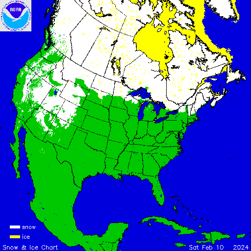
Current NA snow coverage, including Eastern Nevada, Utah, Western Colorado, and states North, all part of the Colorado basin, not the Kern in California.
Curiosity inspired by Spencer’s, pieces above, I found that USGS and NOAA keep pretty good track of inflow and outflow from Mead and Hoover Dam. Some charts at these links. Interactive, so choose your own date ranges and chart types. Historical data also availble to the user.
https://lakemead.water-data.com/
https://www.cbrfc.noaa.gov/dbdata/station/flowgraph/flowgraph_hc.html?id=LKSA3O_H&ptype=3
https://waterdata.usgs.gov/monitoring-location/09421500/#parameterCode=00065&period=P365D&showMedian=false
Attached Chart is outflow from the cbrfc.noaa.gov
Turns out that the largest cities in Arizona, Tucson and Phoenix, and most of Arizona agriculture get their water from the Central Arizona Project diversion canal BELOW Hoover Dam, at Parker, near the Southern end of Lake Havasu.
https://en.wikipedia.org/wiki/Central_Arizona_Project
https://www.cap-az.com/water/cap-system/water-operations/system-map/
The dams at Lake Havasu are dependent on daily releases from Hoover, that normally run from around 7.a.m. to 5 p.m. The attached chart, or similar from the links above, show that the daily draw is concurrent with electrical demand in Southern California, and seasonally driven to support heating and air conditioning, depending on the weather.
If you go back in the record, you will find that the daily draw at Hoover goes up when the lake level is low: Electrical generators require head pressure from the force of gravity on a lot of water. If levels are low, more volume of water must be released over a longer time to meet the same electrical output.
There’s a similar scenario that happens at Lake Powell and the dam at Page Arizona, up stream from Hoover. From Powell, the same water produces electrical demand energy at least twice before it is released to the Havasu complex for drinking and agriculture.
If only drinking water and agriculture were driving water use, the dam release could be throttled to support it, and the international treaties with Mexico. Instead, the lake level for the past several years of low winter precipitation is driven by the need for cheap hydroelectric power to shore up California’s overdrawn electrical grid and intermittent and inadequate (and not at all green) wind and solar industries..
Happily, last winter’s snow pack was pretty good, and this past fall, and so far, this winter, have given the Colorado basin (no where near Northern California) some great rain and a generous snow pack. If this be climate change, then we want more of it.
It is overuse — for electrical production — that drives the lakes’ levels. Even a dry year, or five, produces more than enough for drinking and ag.
They can’t stop draining it at the current overused rate. If they did, there’d be water shortages and power outages.
Not really: being Winter today’s rate of release is pretty low, and there’s been a lot of rain and snow since September. Its a process, not a point. There’s plenty, today, and Mead and Powell are continuing to fill at a rate far beyond the current usage.
See the current water level chart for Mead, attached. Link above previous comment. See the Colorado Basin River Forecast Center map for status https://www.cbrfc.noaa.gov/lmap/lmap.php. Everything in the Basin from Mexico to Idaho and Wyoming is looking good, and forecasts indicate that snowfall will continue in the basin through at least mid-March.
If it was a budgeted release, and not driven high by intermittent wind/solar supply, it would be fine for a decade, given the mean rate of replentishment But as you say, as long as the federal government allow the electrical output from Hoover and Glen Canyon dams to replace real, dispatchable, thermally generated power, they’ll potentially drain it again next time we have a 2-3 year dry spell.
It is short or non-existent Spring-Summer rainy seasons (misleadingly called monsoon) that really hurt. It is just not global warming or anthrogenic climate change, just normal variation and human government mismanagement.