
Concern is growing Hurricane Hilary will unleash a prolific amount of flooding rainfall on the southwestern US and parts of California as it makes a rare move over the region Sunday and into early next week, triggering the first ever tropical storm watch for California.
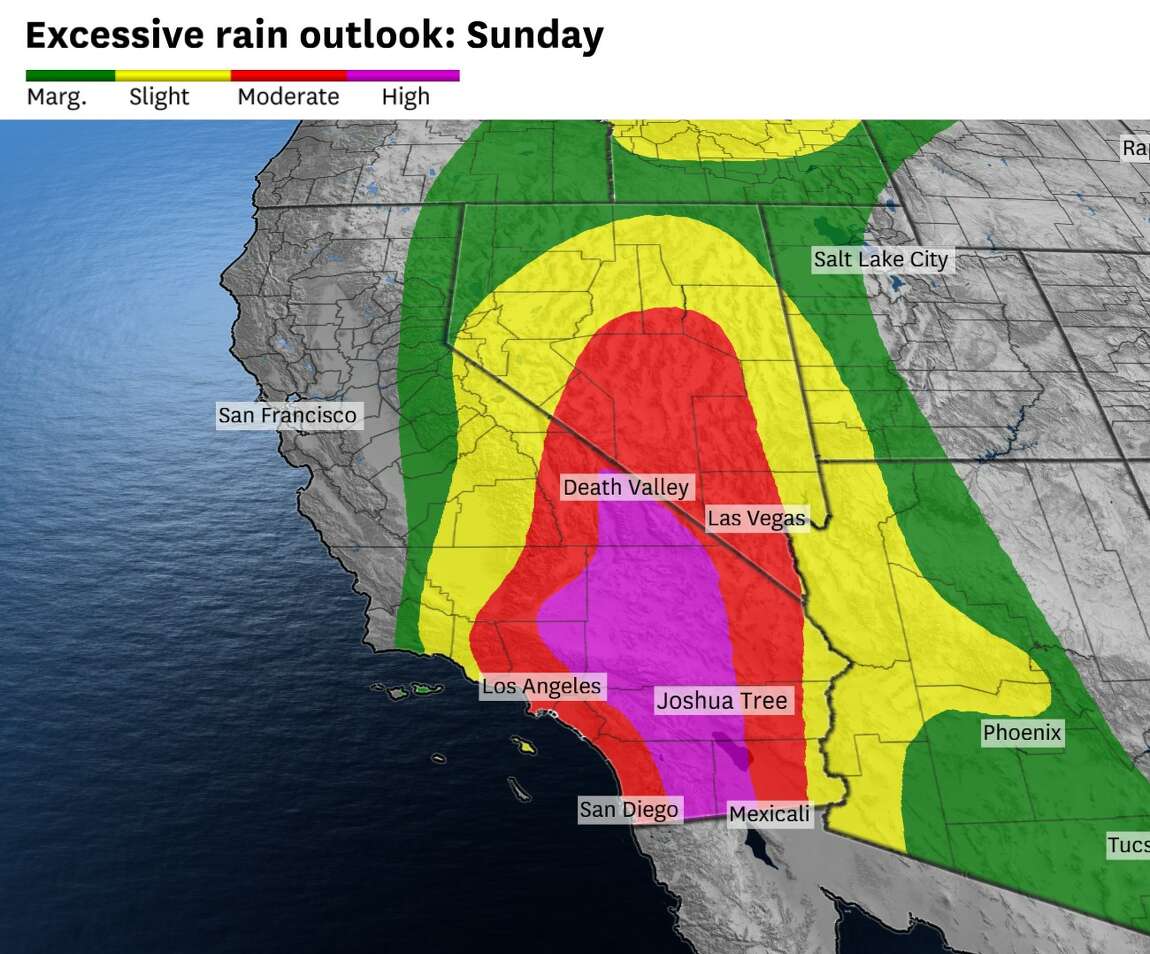
Hilary could dump more than a year’s worth of rain in parts of three states: California, Nevada and Arizona. Because of the threat, parts of California face a rare high risk for excessive rainfall. This Level 4 of 4 threat is the first to ever be issued for this part of Southern California.
Hilary was a powerful Category 4 hurricane churning about 360 miles south of Cabo San Lucas, Mexico, Friday afternoon with sustained winds of 145 mph with stronger gusts, the National Hurricane Center said.
Video Chapters:
0:00 – Intro
0:23 – Major Hurricane Hilary Looking Impressive
4:18 – 12z GFS model Guidence
6:57 – Historic Rainfall Totals Likely
8:30 – Very Rich Moisture In Place
9:07 – 500mb Steering Flow Pattern
10:38 – Spegetti Plots 12:07 – Hilary May Make History
12:37 – Latest NHC Products 17:45 – URGENT Announcment 1
9:35 – Outro/Promotion
https://weather.cod.edu/forecast
Discover more from Watts Up With That?
Subscribe to get the latest posts sent to your email.
There will be flooding in Death Valley.

Historically storms of this type veer off more to the west, and not so much directly north from the current position of Hilary, according to research I have seen. I think the projections this reporter gives for the direction of the storm will take are unlikely to be seen in reality. I suspect there could be some serious flooding the the San Fernando Valley area, as well as localized flooding in San Diego, Orange, and LA counties.
The forecasts have stayed pretty consistent: the weather systems steering the path maintain it, and accelerate it towards dissipation.
https://www.nhc.noaa.gov/archive/2023/HILARY_graphics.php?product=5day_cone_with_line
Here’s the latest rainfall projection
Hurricane Hilary. Started looking strong, looking powerful. Then weakened to be very wet and non threatening by election day. Now everyone is asking “What happened?”.
Dry air entrainment and wind shear, pretty much expected by “everyone else.”
“Very wet” can be considered very threatening. If election day is Tuesday, then the storm will be well past California. The “very wet” may still be around.
I’ve just read that there is an evacuation order for St Bernadino.
It’s going to be a wet August in the western US.
https://earth.nullschool.net/#2023/08/24/0700Z/wind/isobaric/500hPa/orthographic=-120.75,42.35,844
Strong convection over the Gulf of California. A tropical storm is seen in the Caribbean.

A tropical storm is fast approaching Southern California.

Hurricane Hilary’s plume reaches southern California.

Remember the 1930s? No? It was a decade that featured “INSANE” weather.
It was the only time southern California had tropical storm conditions. https://www.latimes.com/california/story/2023-08-17/has-a-hurricane-ever-hit-los-angeles-before notes:
(Hot weather in the 1930s? There was also cold weather.)
There were three other tropical system remnants that impacted southern California that month. From a reference at
https://en.wikipedia.org/wiki/List_of_California_hurricanes :
September 1939, a month with four storms
Four storms affected southern California during the one month of September 1939, including the only storm on record as actually hitting California as a tropical storm. All these storms occurred during the El Niño of 1938-39.
So, I guess Californians better pay more attention to the weather than usual next month!
Hurricane Hilary will introduce tropical storm-force winds, urban flooding and the risk of isolated tornadoes to large swaths of California on Sunday.
https://www.sfchronicle.com/weather-forecast/article/hurricane-hilary-storm-california-18302752.php
Right now, there are very strong NE (CCW inflow?) winds across the San Diego hinterland mountains just above the border – over 60mph.
This circulation will increase convection over California, as warm air from the south will rise over the mountains.
https://earth.nullschool.net/#2023/08/21/0000Z/wind/isobaric/1000hPa/overlay=mean_sea_level_pressure/orthographic=-126.99,40.72,844/loc=-144.156,44.389
https://earth.nullschool.net/#2023/08/20/1700Z/wind/isobaric/700hPa/orthographic=-117.08,38.86,844
Here in Inyokern (Indian Wells Valley, north Mojave Desert), it’s been a steady moderate rain from a uniform cloud deck for the last few hours, about 0.5″ so far. This is nothing like a typical August monsoon, which is more chaotic thunderstorm waves. The track fan center is still about 25 miles east of us,
Turned out to be a BIG nothing burger for most of Southern California, including the cities of San Diego and Los Angeles.
Tropical storm equivalent? . . . don’t make me laugh!
I think you are a bit premature – the center of the storm is still 60 miles south of Ensenada.
Well let’s keep an eye on a San Diego weather station, shall we? From https://forecast.weather.gov/data/obhistory/KMYF.html :
20 12:53 NW 8 6.00 Light Rain Fog/Mist FEW055 BKN070 OVC085 76 72
88% NA76 29.47 997.4 0.05
That’s 8mph NW wind, barometer 997.4mb, 0.05in rain in last hour. Not exciting yet, but let’s keep watching…
Rain was heavy till about 1330, then stopped. 1.8″ since 0500.
Interesting – is that your personal observation, and whereabouts do you live? San Diego Montgomery Field has noted 0.33″ in 6 hours.
Yes, bean can measurement. I have a tomato can backup, identical reading. And my much wider tea tin, but it’s been consistently low, I think it might have a very small leak. I will empty the tomato can tonight in case the bean can gets filled.
As of now, 2.25″ since 0500. About 3″ total including yesterday
.
I’m in Inyokern, CA 93527 — north Mojave Desert.
Given the wind shear, I’d recommend looking at areas north of San Diego too.
The storm has entered Southern California. Heavy rainfall north of Los Angeles.

In San Diego (weather station KMYF) the storm has strengthened by 12% in the last hour. It’s now 9mph instead of 8mph.
NOAA was calling for 1-2 inches of rain over most of southern California. Hardly a deluge of epic proportions. What a contrast between the breathless scare stories and the official weather site for hurricanes.
“Hilary could dump more than a year’s worth of rain in parts of three states: California, Nevada and Arizona.”
In some parts of those states, 4 inches (10cm) would be enough to reach this target.
I remember a couple years of about 1″ total rainfall. I think our long term average annual precipitation is about 3.4″. We are at about 4″ for the storm. After getting the warnings on my phone tonight I remembered to defy the warnings and go drive around to see what it’s like. Definitely wet. And kind of cool. It seems like a strong three day winter pacific storm packed into one day.
A quick calc says 15 million acre/feet of water has fallen in California alone. That is a lot of water. The way I see it, and I’m not grinding any axes here, not much will not make it to the ocean, most will not make it to a reservoir. It will just soak in and grow next years wildfires.
My little patch of Sierra pines has been given a reprieve. Stressed by low water years, bark beetles have been picking them off one by one. Last summer the trees were looking on the verge of giving up. And there have been some heart-breaking extensive die offs up there. The amazing winter snow and now the 4 inches from this storm amounts to over 20 inches since last November. This allows the trees to fight off the beetles – sap them to death. I hope this slows the beetle advance down enough for the forest to survive and reach a water resource balance, in the long run a thinner healthier forest.
The “eye” just passed right over us! I would not have known except that what’s Zoom Earth says.
Tropical Storm Hilary is moving north over the mountains of California into Nevada.

Heavy rainfall in the mountains of California.

Here are stats from 2 weather stations, KMYF San Diego Montgomery Field and KPSP Palm Springs Regional Airport.
KMYF max wind 21mph, max gust 31mph at 20:53 20th, max 6-hour rainfall 1.08in.
KPSP max wind 30mph, max gust 45mph at 18:53 20th, max 6-hour rainfall 2.27in.
The media are reporting Hilary as a tropical storm landfalling in California, first in 84 years. Don’t believe it, its landfall was in Mexico (Baja California) and by the time it reached SoCal I would like to see any measurement of sustained winds of 39mph (TS threshold, also known as ordinary gale force in the UK).
I’m glad to hear that there are no reported Californian storm deaths as yet.
Inyokern Ca 93527, Indian Wells Valley (“two Valleys from Death”), north Mojave Desert.
My rain gauges show 4.55″ rain for the period 8/19 1900 to now. Almost all of that in the 12 hour period of 0700 to 1900 yesterday. Rain was heavy at times, but never crazy. We had winds 30 – 40 gusts for about an hour in the early afternoon. On my drive around last night I saw all of the little wadi’s had some flowing water. This isn’t something I haven’t seen before.
All in all, it was unusual and fun for us. The nearby bigger town of Ridgecrest had lots of static and flow flowing, but hey, a third of an inch in one downpour does that there, it is a desert town. The water will be appreciated, especially in the mountains. Though it means the fireload increases, it also gives the trees a chance against the bark beetles.
I’d give this one a Lettuce to Veggie Patty Burger rating depending on location.
Isn’t this storm pretty much a part of the normal monsoon flow for this time of year?
Just 100 miles west of the usual track?
Not at all. The usual “monsoon” subtropical system originates in the Gulf of Mexico spreads north and west through Mexico into Texas, New Mexico, Arizona, and into maybe into California and Nevada, It’s a broad regional flow, not an organized tropical storm.
Stopping almost always at Barstow and Las Vegas. We see the far off cumulus build up and lightning at night, get the humidity, but we don’t get the storms and rain!
We very occasionally get the nearly dead remnant of a Pacific hurricane in California, kind of like if this Hilary system had played out 400 miles to the south. Might be mentioned in the news but not pumped up like this.
I see that parts of Death Valley have received about two centuries of rainfall (i.e. 2 inches)
This is not the end of precipitation in California, as a stationary upper-level low has settled over the coast.

Precipitation has moved into northern California.