From Dr. Roy Spencer’s Global Warming Blog
September 29th, 2022 by Roy W. Spencer, Ph. D.

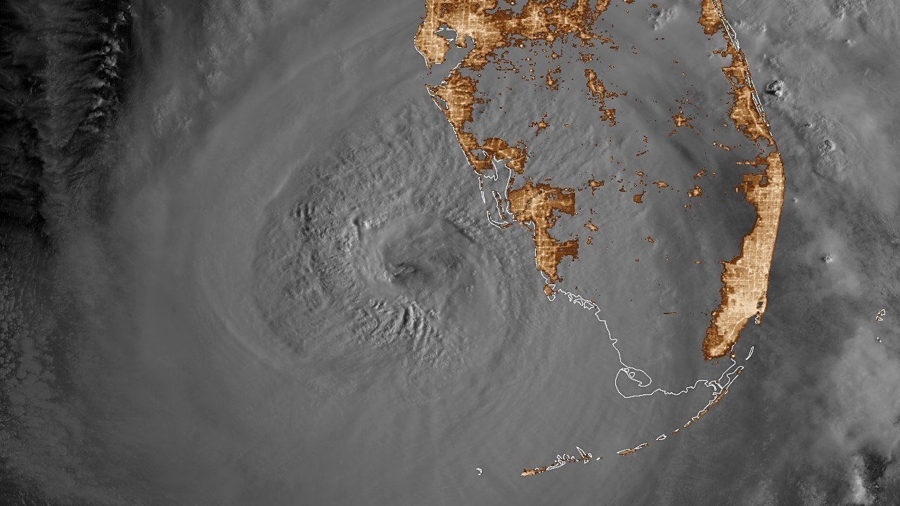
With Hurricane Ian (now a tropical storm) exiting the east coast of Florida, there is no shortage of news reports tying this storm to climate change. Even if those claims actually include data to support their case, those data are usually for cherry-picked regions and time periods. If global warming is causing a change in tropical cyclone activity, it should show up in global statistics.
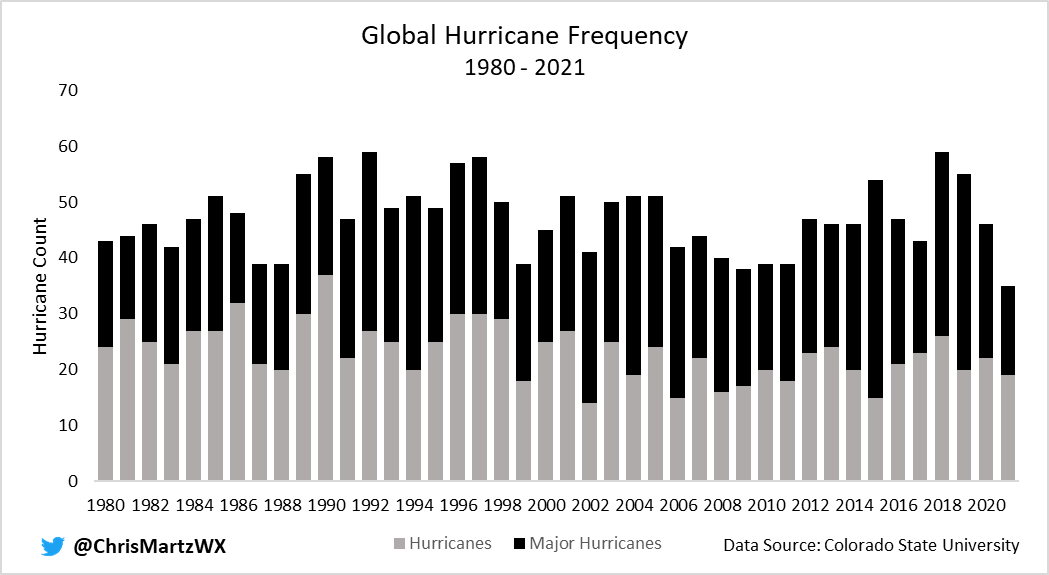
The latest peer-reviewed study (March 2022, here) of the accumulated wind energy in tropical cyclones since 1990 (when we started have sufficient global data) showed a decrease in hurricane activity. There was an increase in Atlantic activity, but this was matched by an even larger decrease in Pacific activity, due to a shift from El Nino to La Nina conditions during that time.
So, yes, there is climate change involved in the uptick in Atlantic activity in recent decades. But it’s natural.
Looking at just the numbers of global hurricanes since 1980, we see no obvious trends.

Even if we did see an increase, the improvements in global satellite monitoring would be responsible for some of that. It is impossible to talk about meaningful global statistics (especially trends) before the 1980s due to a lack of satellite data. Ships of opportunity are insufficient for trend calculations, especially since ships try to avoid storms, not sample them.
A document-based study of hurricanes impacting the Lesser Antilles since the last 1600s found a downward trend (not statistically significant) in hurricane activity during 1690-2007.
In my 2017 Kindle book Inevitable Disaster: Why Hurricanes Can’t Be Blamed on Global Warming, I looked at major hurricane landfalls in Florida, which showed no trends. With Hurricane Ian and Michael (2018) added to the dataset, there is still no statistically significant trends in either intensity or frequency of landfalling major hurricanes in Florida.

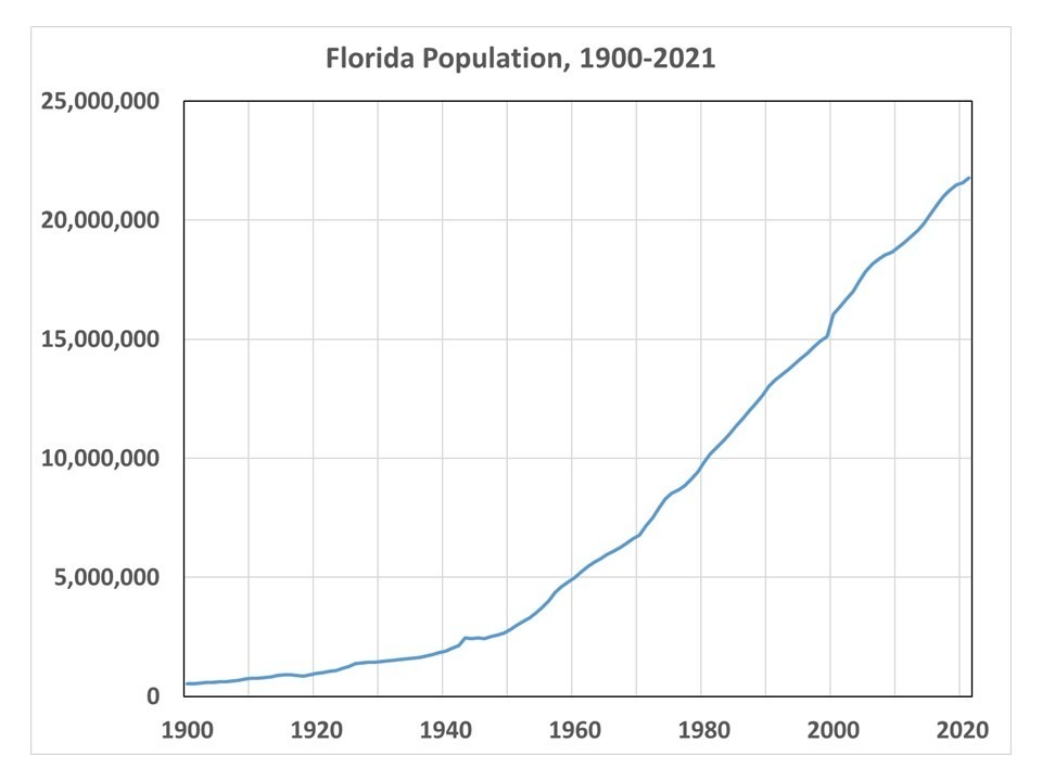
Of course hurricane damages have increased dramatically during the same period, but this is due to the explosive growth in coastal infrastructure there. Miami had only 444 residents in 1896, and now the metro area has over 6,000,000 population. As seen in the following plot, Florida population has increased by a factor of over 40 since 1900.

Yearly population of Florida, 1900 through 2021.
Given that hurricanes will always be with us, what is the best defense against them? Wealth. Hurricane Ian came ashore with 150 mph sustained winds, but warnings from modern instrumentation and forecast tools led to mass evacuations. At this writing, only 5 deaths have been reported (I’m sure that will rise). Modern building codes help reduce wind damage. I watched storm chaser Reed Timmer live reporting from the eyewall of Hurricane Ian as it made landfall, and I didn’t see any roofs coming off the houses (but I’m sure there were some that did). Damage from storm surge flooding, however, will be extensive and costly.
Roof tie-down clips do matter, as do actually enforcing building codes.
Can you imagine how bad the hurricane damages would be if NYC-building-inspector level corruption was allowed to fester in Florida!
Imagine if one of the strongest ones to ever hit Florida hit an area that has not seen a direct hit from a major hurricane in several decades?
Or like the Tampa Bay area, not since 1921?
It does not matter what the codes are recently, or who was inspecting recently, when there are structures that have been built over many decades. Just the places where people dare to build defies belief when there has been a lull in what is, historically speaking, a very hurricane prone state.
After many decades of several major hurricanes per decade, Florida by the early 1960s was sparsely inhabited, outside of the big cities. In fact, my recollection is, it was like that on most beaches along the Gulf Coast and East coast of the US back then.
But especially starting in the 1980s, after over a decades with nary a strong direct hit by a hurricane, the beaches basically started filling up wall to wall with real estate. Everywhere.
Cape Coral was originally built and platted as part of an elaborate scam. Land was sold all over the world for dirt cheap. It was buildable, but there were no utilities and no services. It was not as bad as the scams involving selling people land in the Green Swamp, but to this day, there are paved roads with lots all along both sides, what must be hundreds of miles of streets, and many…many…have one or two or even no homes on them.
Same in Lehigh Acres, which is even larger but inland.
Anyhoo…at this point, there is almost no place for a hurricane to hit the US where it will not do immense damage and be incredibly disruptive for a lot of people.
So what happens when we go back to a phase of storms that hit several per year sometimes, intense hurricanes slamming directly into Florida?
What happens when a cat 5 slams directly into Miami at peak intensity?
That happened a bunch of times in the earlier parts of the 20th century.
But it has not happened in a very long time. Andrew was very compact and was far enough south that Miami and Fort Lauderdale (not to mention all the dozens of other beach towns lining every inch of that coast all the wall up to Martin county) had barely any hurricane force wind.
Wilma did immense damage to parts of south Florida, but it got almost no attention because it occurred in the aftermath of Katrina, and was supposedly only a cat 1 storm.
That eyewall…in a major hurricane, it is the same as being in a tornado that is tens of miles wide.
But like a tornado, outside of that intense core, it is really windy for a long time, yes, but it is like a tornado that hits across the street.
Inland here yesterday, we got very lucky because dry air was wrapping in and weakened the east side of the eyewall, and windshear pushed most of the rain north of the storm. Locations within ten miles of me got 20″ of rain yesterday…I got maybe 6 or 7, on top of a wet rainy season and 4 inches on Tuesday.
Now, I am not as morose about the consequences of all this building in hurricane prone coastal areas as I used to be. Homes can be built to stand up to even cat 5 winds that go on and on for hours and even days.
Like the one I am in.
But the ones near the water, when it is inevitable there will be a 10-20 foot storm surge someday?
I can tell you…we just lost many tens of billions of dollars worth of real estate, just yesterday, just here in SW Florida.
Hurricane Charley?
Yes, only 18 years, since 2004 for where this one hit.
But I was referring to Sarasota. Or any of the other places that have dodges all the bullets for a very long time.
Jax was notable for a while for not having been hit directly, and some people said it was basically impossible due to the shape of the coastline. but that shape, concave, also means storm surge will be really bad in the bight North of about St Augustine.
Fort Myers has actually been hit by a number of hurricanes in the past 20 years…like, as you said, Charley, and also Wilma. Before that, Andrew apparently did a real number over here too…but I was living in Pasco county for that one.
Charlotte county supposedly has increased population by 30% just in the past several years.
All of the SW Florida region has had explosive population growth since Charley, which has both favorable and unfavorable aspects for such matters.
Lots of the structures are newer, post Andrew and even better, post 2004-2005…those two bad years. Codes got beefed up bigly after Andrew, and even more so after 2004 and 2005.
But also, lots of people who have no idea how to react when hurricane threatens.
Most people have never been through a bad hurricane, but the number that never has just went down by several million.
A large part of the downside has been the frenzy to build leading to a lot of bad decisions about where to build homes for millions of new Floridians.
People just love to live on the water.
Everyone obviously knows hurricanes happen, so why do so many Choose to live where they stand a chance to be flooded or even worse, wiped out?
Afterward, most people seemed stunned that it really happened.
Then again, most people have insurance.
I hope most of them know that homeowners does not cover flood damage.
My stepaunt’s daughters teachers nephews brother in law’s trash collector, has a side gig that earns her beau coup ducats in the privacy and comfort of her own bedroom.
Hard to believe, but she is actually a pr…oh, wait…I cannot talk about any of that here.
Totally inappropriate.
You should be ashamed of yourself.
Just want to say, this comment I made was not a reply to Tom, but to a deleted spam comment.
Stop the spam, ban the bot?
we need a randomized controlled test.
Actually they do test proposed building code changes.
They build a structure with the proposed standard and put it into a wind tunnel. They also use air guns to shoot debris at the test structures.
Steve, one of these days you just might actually be able to learn half of what you think you already know. But that can’t happen unless you get rid of your anger towards those who keep showing you how little you currently know.
One way such building code revisions are arrived at is by looking at the specific failure mode of structures that got destroyed, especially vs those nearby that survived intact or largely so.
Something that few were thinking about at the time was garage doors.
It became apparent a large number of homes in Homestead, Florida (and other places nearby, Cutler Ridge, etc) were wrecked by Andrew when the garage door blew in. This let wind blow directly into the garage with no way for that air to get out. The results was lifting force on the roof, and once a roof began to separate from the walls supporting it, failure of the whole structure was inevitable. So now garage doors must meet strict standards. And even a cat 5 rated garage door is not very much more money than a crappy one.
Another was thought to be regarding how plywood or other roof sheathing was attached. At first it appeared to be the case that staples instead of nails was the culprit in a large number of failures. But it turns out to be more true that how many fasteners, rather than just what type, was the critical factor, and also that in a large number of cases, a large number of fasteners had missed the member they were suppose to be nailed or stapled to. IOW, people doing sloppy work had put nails or staples into sheathing that did not hit the truss, or hit the edge and did not hold strongly.
We have all seen that a common mode of structure failure is a result of a progression of events. Preventing a weak link causing a whole house to be blown apart by wind is achievable.
That can be seen in almost all hurricane aftermaths in recent years.
Adjacent homes, one wrecked completely, the other completely intact.
That is very apparent in many of the photos of the Ian aftermath.
Flood damage is another story. many of the homes near water may look to be intact, but in fact were under water during the surge. I am not sure how what it takes to restore a house that has been submerged in salt water, or if at some point it may be called a total loss by the insurance adjustors.
I suspect if the structure is intact, it will be less money to gut it and renovate the existing structure, but it is also possible that ongoing corrosion of fasteners etc, and who knows what other sorts of damage from the salt, will make it cheaper to raze and rebuild.
I would imagine that most of the cost difference would be in the mounting brackets.
I’ve done work on renovating homes after fresh water flooding. I hadn’t given any thought to the problems caused by salt penetrating wood and fixtures, and the long term consequences of that contamination.
“there is climate change involved in the uptick in Atlantic activity in recent decades. But it’s natural.”
One bit of climate change that the graph on Atlantic hurricanes seems to be a proxy for is the “Dreaded Pause” 1997 -. The last few bars are even displaying the recent downtrend in temperatures that is creating new angst among modelers and doctrinaire AGW catastrophists.
Big hurricane frequency has got to be one of the worst metrics for assessing climate or climate change over the commonly used 30 period.
They are so infrequent as to make attempted use of statistics look foolish when one may only have a handful of cases to report.
Expanding the area to increase the number of samples doesn’t make sense either. New York clearly has a different climate to Florida.
the question is do you want to be on the business end of a hurricane that
A. traverses over 70F sea water OR
B 90F sea water?
its pretty clear
And once again, Steve pulls out one of his red herrings.
Even the IPCC is only claiming that ocean temps have warmed up by about 0.03C. At this rate it will take a few hundred thousand years for ocean temps to warm up by 20F.
Why don’t you present a scenario that actually has a faint chance of occurring.
Until then you just continue to make yourself look desperate.
From all I have seen, the flooding has been catastrophic, Florida is just such a flat place, and that with very high winds, high tides, 12+ inches of rain, is a very bad combination.
The early forecasts of a more northerly track certainly didn’t help. By the time some people knew they were going to get a direct hit, it was too late to go anywhere.
Everyone in a place under a hurricane watch ought to know that forecast tracks and cones of uncertainty are guesses, and that almost always, the storm hits dozens of miles from where it was forecast to strike the day before.
And besides for that, over a period of several days, the forecast moved from exactly where it hit, up the coast to the panhandle, and then back south.
At various times ahead of landfall, it was forecast to hit right where it did.
My perception is, the storm did exactly what was being indicated for days ahead of time. Rapid intensification, a right turn after passing over Cuba, no disruption from passage over land, and then at some point it was going to get pushed to the right by a trough building in from the north and west.
No one should have ever been given or had the idea that anyone knew exactly where the storm would hit, even up to and including a few hours before it struck!
A few hours before landfall, it wobbled to the left and it appeared it would hit Sarasota after all, but then it wobbled back to the right. And when the right side passed over land, it slowed on that side and so naturally turned in that direction. Same thing when the right half of it passed over Cuba…it emerged dozens of miles East and on a more easterly trajectory that the forecast track.
Weather and news people should always…ALWAYS…emphasize the uncertainty, and explain what that cone means. And point it out when it keeps changing day to day…that means the computer models are not in agreement and there is large uncertainty.
Een when the forecast track…the center of the cone, was having it hit north of Tampa Bay, the south side of the cone included where it wound up hitting.
Fort Myers was never out of the cone.
But the spaghetti models showed large uncertainty, all along.
Some models had it going straight into Mexico, before it hit Cuba, and other had it hitting anywhere from Naples to the panhandle.
Tha continued to be the case up to landfall…some clustering in the models, but a few disagreeing and showing it going east sooner or later, or just heading mostly straight north.
Also predicted was a chance of dry air being entrained in and weakening the south east quadrant especially. Also known ahead of time was that wind shear would disrupt it somewhat and push most of the rain north of the center, but it was unknown if that would happen soon enough to matter.
People think the cone of uncertainty means something other than what it means…it is simply the slice that encompasses a 50% chance of the center of the storm passing over those location. It has nothing to do with the size of the storm. Wider cone means more uncertainty. I heard even news reporters seeming to be stunned that in Naples they had bad damage even though “we are outside the cone here”!
Irma did the same thing. Over a period of more than a week, the forecast track, the cone of uncertainty, shifted from West of the peninsula, to east of the peninsula, to right up the center, and then back to the west and east a few times.
In the end it went where the most similar other storm had gone…Donna had a similar path and intensity, and it went where Donna had gone, largely and up to a certain point.
This one came from the same place as Charley. Charley was forecast to hit Tampa, then passed over Captiva and Punta Gorda and did big time damage in central Florida, including roofs torn off and flooding in Orlando area. It even hit at the same time of day.
But Ian was wider and was intensifying at landfall. It retained hurricane, major hurricane, status well after making landfall. Charley lost most of it’s core of hurricane winds pretty quickly.
And on top of that…2004 was when the building boom was just getting started around here. We had five years in which they built 20 years worth of houses, then the crash, and more recently, a more prolonged building boom around here.
Back in the 1990s, there was basically nothing along I-75 between North Port and Naples except a Waffle House and an Econo Lodge at Bonita Beach road. I mean nothing.
Now, Lee county is densely inhabited.
Hell, I can recall when at the turn near Naples on I-75, back when I had a plant nursery in the late 1980s and early 1990s, I used to drive through there all the time, and I was stunned when I saw them clearing out swamp near that toll booth…I thought…they cannot build anything in that swamp.
Now that are is hundreds of billions in real estate..high end stuff.
You used to have to drive 20 miles West or South from that turn on I-75 to even get gas…practically to Marco Island. Naples had like three dozen old people living there and a diner.
Every other part of Florida is the same.
Going back to the 1970s, when I was helping my sister run a plant store in Lauderdale Lakes near Sunrise Blvd, we were living in Delrey beach, and the turnpike for that entire distance, Fort Lauderdale to Delrey, was unbroken cypress swamp on both sides.
Tens of thousands of square miles of what had been wilderness, farms or ranches, or just scrub, is now fancy real estate and gated communities here.
I’m shocked, shocked to find that there is a gamble in the predicted paths of hurricanes!
I know!
Amazing, innit?
The real gamble is made by blithe people who assume that storm forecast tracks can be counted on, when the result of them being off by a few hours, a few degrees, a few tens of miles, is the difference between life and death for the unfortunates who wind up in the wrong place at the wrong time.
Without wanting to seem callous, someone should set up a real-time spread betting system so people can make money against potential insurance company losses.
It would make for great TV, and might actually lead to better prediction outcomes.
I think the WUWT post on European path predictions verses the US showed how bad the US predictions were. ( like outside the entire spread)
I read some of that, but my understanding is that none of the models is consistently accurate, which is why after all these years they continue to use the same approach to forecasting using them.
It is easy to say after wards that one set of models or predictions was more accurate.
And if in every situation that continued to be true, no one would pay any attention to the ones that are always wrong, and always rely on the ones that are always correct.
But none are always correct, none are always and consistently better than all the others, and none are always wrong. (At least, as I said, that is the way I have come to understand it)
It is like stock market prediction…afterwards, there is gonna be people who correctly predicted what wound up happening.
But those same people have been famously wrong at many other times.
Making predictions is difficult, especially about the future.
Yogi Berra
IOW, using a sample of one to say that this model is better than that model is ridiculous.
It may be true, but one or a few selected examples does not demonstrate that.
Cliff needs to do a better job of making his point if it is a valid one, than showing a sample size of one, and then just asserting that it is not the only time it was this way.
How about all of them, for the last five years?
It’s been that way for decades. The United States is no longer the world leader in atmospheric sciences. Funding is a big part of that. But I think apathy and sometimes resistance to science in general is playing a role as well. This is just my opinion and I know a lot of people (especially on WUWT) will disagree, but.it does seem like there is a war on science going on in the United States right now with near term weather forecasting and especially long term climate forecasting receiving some of the collateral damage.
There is no war on science, there is a war on politics trying to dress itself as science. Though I suspect your average socialist is unwilling to see the difference.
The only place where US science trails is in the so called “climate” sciences. And that’s only if you consider the nonsense being peddled as actually being science.
I remember vacationing in Orlando during Irma. Not only did it switch predicted sides, East to West, a few times, even after landfall, it was supposed to turn East before arriving in Central Florida, but ended up just plowing up the center. Being a tourist who had never experienced a hurricane, when it became obvious Irma was not going to turn East, I was close to panic. But in the end, of course everything was mostly fine. Our pool screen was destroyed, and lots of bugs and stuff in the pool, but other than that, no damage. Oh, and the waterparks were closed for a bit 🙁
I lost power and cell service and so had zero info my mid-morning the day Irma struck.
I did not get power or internet back for about three weeks, and by then, it was hard to find anyone even still talking about the storm.
So I have a huge gap in my knowledge of that event I lived through, starting at about the time the thing hit the Keys.
It was such a big storm, I was already getting rain and near or over TS force winds for almost a full 24 hours by the time I lost power, and that was when it was just getting set to move on my neck of the woods.
If you are not flooded, and are not near water, about the worst that can happen is no power for a long time.
Not having power for an extended time is just a miserable experience.
I was just checking the electric co-op site…50% of people in my zip code are still without power, and over 80% of customers overall.
I think it is something like 2.4 million for the whole state.
You are correct that the media makes it sound like if it gets near you, you will die, but the truth is the worst of these storms is almost always a small area right where it makes landfall, and then for a ways inland of there.
The worst physical property damage that is. Not always, but most of the time.
The core of winds above hurricane strength is almost always no more than a few tens of miles wide.
But…any areas that get prolonged winds of over about 50mph, I would say and in my experience, is going to start getting power outages, and if they are widespread, it will take a very long time, weeks, to get everyone back reconnected. By 60-70 mph, losing power is almost assured.
I still am amazed and shocked I did not lose power in this one. Especially because it was flickering and voltage kept dropping and it went off for a few seconds, for hours in a row like that. Must have been branches rubbing against the lines but somehow nothing broke and no breakers tripped.
I love these maps of the wind history. It makes it very clear in an easy to see and comprehend way, not only how wide the effects are spread out from the center, but also which direction the storm is trending. Much better than just seeing the numbers and headings.
Look how small the core is compared to the whole wind field in the pic I attached below.
Something qualitatively different seems to arise when the wind gets above a certain point. Two separate ones, really. The first is not tropical storm force, it is higher, around 60 mph. Maybe that is because homes and structures in general are stronger and more water tight than when these standards were devised.
The second point is around 80mph. Above that, it just seems different. Maybe it is the sound, maybe because it is the point that things start to break and go flying hard enough to kill a person, or maybe because it is when it is hard to stand up straight, or when the rain starts to really hurt.
After being in them, it is easy to understand why at around that wind speed, it becomes a whole different thing, with a separate name.
Here is the same for Irma:
I have been in Florida when 16 inches of rain fell in a few hours. It just disappeared. the soil is sand going all the way to a deep basement.
After eight months of dry season, like in May, no amount of rain will pond up for long in the places that have a deep sand layer.
But at the tail end of a very wet rainy season, it is a different story.
And while there are large areas of very deep sand, there are also large areas with a clay hardpan, or limestone bedrock just a few inches to a few feet down.
And one reason rain can “disappear” here so quickly is because a lot of money has been spent engineering excellent and extensive drainage infrastructures. Not just because it can percolate into the subsurface layers so readily.
There are swales, ditches, or canals on both sides of almost every road and street in the state, except in areas that have retention ponds and drains in the road.
Even the natural lakes are connected to each other by massive underground pipes, forming whole carefully engineered systems.
Many part of the peninsula have networks of long canals complete with gates and locks to control water flow.
That rain does not just mysteriously disappear to depths unknown. I have 16 years of experience working for a lake and wetlands management company here, so trust me, I know a thing or two about the hydrology here. Even besides for the years I spent studying physical geography here at a Florida University.
And 16″ in a few hours?
I have lived here for many a year, and seen many a hard rain.
Back in 1985 (or maybe it was ’86) there was a stationary front during the typically rather dry month of March, when I was living at the plant nursery in Pasco County.
It rained and rained and rained…and then one evening I emptied a huge plastic trash can and left it in the middle of the lawn in front of the house, since I did not have a rain gauge.
The next morning, that trash can was all of half full. But also the next morning, the normally dry swale that runs through our property was a rushing river.
All that water formed a pond on the next property over, refilling a dry lake bed called Bird Lake, which had not had any water in it since Pinellas County had installed an entire well field about 10 miles west of that location. It took two years for that lake to become a dry bed again.
That week, every river in Central and West Central Florida had awful flooding, even though it was march and so came after most the dry season had elapsed.
This time of year, in that location, after this past very wet rainy season…16 inches in a day is gonna cause a big problem for some people.
The Peace and Myakka Rivers were already in flood stage last week.
In any case, 16″ in a 24 hour period is not unheard of here, but it is very infrequent.
It mostly happens in tropical cyclones, but as I noted can also occur just because of a frontal system, or even, conceivably, a stationary summer thunderstorm.
But again, 16 inches in a few hours?
That is a lot of rain and does not happen often.
How did you know it was 16 inches?
The Floridan aquifer can recharge faster than most in the, but not 16 inches in an hour.
Well water would be undrinkable if it went from surface to deep underground that fast.
How deep retention ponds can be dug is tightly controlled for that very reason…a direct route from surface to aquifer would ruin the drinkability of a very large section of the aquifer for a very long time. The Highland Ridge that runs up the center of the state, and is basically a two hundred mile long, hundred foot + high sand dune that blew down from Georgia during the last ice age, has pretty much unlimited infiltration rates and ability. In places. But there are ponds and lakes up there.
If it all soaked in that fast, there would be no rivers, lakes, or stream here…and there are lots of them. Because there are clay and rock layers not far below the surface in many places, including some on the ridge.
Here is a study that looked at all rain events at 48 weather stations in Florida for the years 1949 to 1999. On average, a given location had 4 events in 50 years of 7″ or more within the span of 24 hours.
Check it out…it is a very interesting study:
Anticipating Heavy Rain in Florida – Florida Climate Center (fsu.edu)
how many miles of snow did you walk through to get to school as a kid
They cancel school in snow where I came from.
weak, we had to walk 10 miles through snow and it was uphill both ways
Center City in Philadelphia is very flat, and it mostly rains and stays around 33° when everyone else is getting snow.
Everyone I know loved snow as a kid in Philly.
I still like it, just do not see much of it.
It really is sad when someone becomes consumed by bitterness.
dude told a story. not data analysis. so you love stories
cause you dont know stats.
me ive heard lots of stories. boring
So full of bitterness that he can’t even admit it to himself.
Yeah we all know and love well your keen data analysis skills, almost as much as your insightful and scintillating commentary.
YaaaaaaY Steven!
they looked at model spread and thought
this isnt science
The looked at comments from Mosher and concluded, this guy is not contributing anything helpful to any discussion.
its not my job to help markW understand math
Nobody said it was.
However you aren’t trying to help anybody, you just spout meaningless snark and try to pretend that you are funny.
It’s sad in a way, how you are so willing to degrade yourself over and over again, just because you can’t admit to yourself how badly broken the AGW scam has become.
think about the number of times people have looked at climate model spread and said
yet with hurricanes we understand what it means and use it
I’m going to go out on a limb and guess that you are actually stupid enough to believe that because hurricane models are somewhat usable, that this proves that climate models are equally useful.
Perhaps you might start with reading and understanding the distinction between weather and climate.
Let’s get down to brass tacks: Just to start, do you believe that CO2 is a dangerous pollutant that must be eliminated?
And do you believe that the level of CO2 in the atmosphere is the temperature control knob for planet Earth?
They are both yes or no questions…no storytelling required.
Is your embarrassment and bitterness so great that you can’t even try to be pleasant?
Snark is not pretty, and it only serves to demonstrate what a shallow person you have become.
did i hurt your feelings snowflake
Is that really the best you are capable of?
Don’t answer, I already know that it is.
Will you ever get tired of embarrassing yourself?
In support of Nicholas McGinley’s points:
https://www.nhc.noaa.gov/archive/2022/IAN_graphics.php?product=5day_cone_with_line
At no point was the eventual landfall outside of the cone. It was right on the edge of the cone for a while, but still within the cone.
Thank you.
I really do appreciate your posting this. I use this site all the time but was not aware of this archive of previous forecast cones and positions.
normally, in the past I have saved all of the images from each prediction cycle for important storms in a separate file, but this time I neglected to do that.
So this is a great aid to help me verify that my memory is/was correct and accurate.
All the way back to last Friday, the 1st advisory was prior to it attainting tropical storm status, it was just slightly west of a line due south of Puerto Rico, and the official forecast had it hitting as a hurricane almost exactly where it wound up.
As the days went on, I followed it very closely because of that, where normally I would not be very concerned about a depression way down there. South of 14 degrees north latitude. So when it got to be Sunday morning and it was still not north of 15°, and was by then due south of Miami, near 80° West longitude, and BTW was still seeming to be veering south of due west, I was the most hopeful I had been so far, even though the forecast had it still hitting Florida on the West coast near where I live. But at that point the forecast (“forecast” meaning center of the cone in this context, even though that is not exactly what the center of the cone really means).
But I also knew that weekend and especially Sunday forecasts are often not the best ones, because obviously people do not work 24/7 just because a depression is on the board way down there.
As you noted, even then the Fort Myers area was in the forecast cone, and also by then it was being forecast to undergo rapid intensification to a major hurricane and retain that status even after passage over Cuba.
The thing is, when some influence is known to be coming into play at some particular time, like the trough/cold front moving down in the Southeastern US and into Florida, and it is known that this will kick the storm to the right, it is still a very tough call to predict exactly where in the map the center will be at that time, and therefore where and when it will turn, and therefore where and when it will hit land.
Notice that the first advisory correctly guessed that the center would be approaching Fort Myers from the SSW, and would be nearing shore at 2:00 AM Wednesday morning. That is almost exactly where it was and when.
There should have been more emphasis all along of the forecast uncertainty, how much and how quickly the forecast tracks were changing, and that the most important thing to keep in mind is that a major hurricane will be in a place where it can and will make a right turn at some point, and the timing of that turning, and even the wobbles, was central to knowing where it would eventually make landfall.
IOW, how fast would it be moving at every point in time would determine where it would end up.
I for one knew that no matter what the official forecast was saying, or what weather people talking heads were saying, it was getting very strong and had an excellent chance of coming directly towards where I live. On Monday and even Tuesday, I was not hearing anything close to what I consider the appropriate amount of uncertainty about the eventual point of landfall, let alone specific warnings and admonitions of the reality that weather forecasts are not facts, they are guesses. I do not even recall anyone pointing out that the south side of the cone means that is where the center may well be. It seemed to me that even forecasters and weather people on TV seem to speak as if the cone is the size of the storm, and the center is where it will be, rather than the whole cone being the range of places where the center is likely to be, and the center just being the middle of that range…not even necessarily more likely than any other spot in the cone.
I was at a gas station, at Costco, and at a Walmart on Tuesday morning and early afternoon, and there were no lines. Walmart had huge pallets of gas cans for sale in front of the register.
I was at Northern tool and they had stacks of generators…on sale!
If people knew there was a very real chance a hurricane was gonna hit and power would be out within 24 to 30 hours, those places would have all had long lines, and nary a gas can or generator or anything else would be for the buying.
Costco had stack halfway to the roof of bottles of water, and few takers, but I did notice most people has at least one case in their cart.
The only line I saw all day was a traffic jam leading into Chick Fil-A.
I thought it was people trying to get to Northern Tool!
I spent the rest of Tuesday cutting some limbs from trees outside the front of my house, and getting my storm shutters down. I got stung by wasps clearing vines from one of them. I was planning on chopping the brittle Royal Poincianas to stumps, after what happened in Irma, but I ran out of daylight, and knew I needed to get some sleep. I never got any. By morning (3:00 AM), it was too windy to cut trees, and at that point I had been online at every source of info I could think of.
Some of the comments and commenters here baffle me, frankly.
Like the assertion that no land based stations had measured cat 4 wind.
Cape Coral, which is on the other side of Sanibel and Captiva and also Pine Island, so two land masses from open water, recorded a 140 mph wind.
I do not know what “gust” means. it is not a well defined or scientific term.
I have a feeling many people who opine on all of this have never ever once themselves personally ever stood outside or even been inside a house in the middle of a hurricane, let alone a number of them that would allow some perspective over time, and the sense of the power of it that they impart.
The wind in a hurricane is not at all like any other kind of wind.
It is not like strong mountain top wind in Winter behind a cold front blowing down from Canada. It is not like gusty Autumn wind that goes on for days on the Mid Atlantic or Northeastern US.
The gusts build up, and you can hear them coming from blocks away…and in Florida a block is about half a mile to a mile.
You do not forget the sound. The pitch of it rises as wind speed increases. It comes from all around, the trees for a thousand feet in every direction are announcing the wind speed, like a quarter mile wide anemometer that does not break and speaks to you on a nearly emotional level.
The gusts build and build as the rain falls suddenly in a blinding sheet that feels like it is injecting water into you like a hypodermic needle.
The gusts d not last for a moment, and they are not a “spike”. I have never felt a wind spike, or heard one, in a hurricane.
Why is it so much windier in the rain bands and windiest in the strongest cells?
Because the rain drags the wind down from aloft, just like snow can drag cold air down from aloft and turn a predicted rain into a blinding blizzard.
The worst damage in Hurricanes has always been from imbedded tornadoes.
Some of them have a large number of such tornadoes, others have very few.
The spinning is far more destructive than the same velocity in a straight line wind.
And just like it is easier to pull a stump out of the ground by sudden jolts than by steady pressure, it is easier for sudden bursts of wind to do damage than the same wind force that is steady and even. If you wat to pull a stubborn nail out, you apply steady pressure and then slap the front of your fist. Far more effective than just pulling harder.
I do not know why wind speeds in hurricanes that are given as the max winds seems to rarely if ever be measured by ground based stations on a widespread basis, but I am sure that this was a major hurricane, with a large and powerful wind field.
Cat 1 storms, and non hurricanes, do not lift the entire ocean up by 15 feet and send it onto shore:(1) 15ft Storm Surge Washes Away Homes in Ft. Myers Beach – Hurricane Ian – YouTube
It can be calculated how much wind force it takes to propel a given mass/height of water onto shore.
This kind of surge does not happen in a stiff breeze. It takes a major hurricane to push 15+ feet of water onto shore.
Low barometric pressure helps.
Yes, it is a factor.
But it is small in comparison to wind.
In fact, the relationship between pressure and surge is well described, and typically amounts to about 1/10th of a total surge.
Also important is the time and amount of high tide. This storm did hit at high or nearly so, IIRC.
Many Safir-Simpson scale charts include a range of storm surge values that correspond to a given wind speed and pressure.
The video I linked to shows the ocean rising up to what appears to be about 12′ above a city street in Fort Myers Beach.
To even get to a few inches deep at that spot, the water would have to be a number of feet above high tide levels.
And everything I have found (and I have been doing a lot of looking) that is published on the subject indicates that storm surge of over 12″ requires a cat 4 storm.
To me the real question is, how to recent storms compare to historic ones, i.e, ones more than say a decade or two ago.
Exaggerating wind speed of hurricanes seemed to have not been a thing back in the 2004/2005 storm years. So we may be only having to look at the past ten years or so.
From what I have seen, no one is using the video evidence of 12″ sea level rise as a reference to how much surge there was. At this point the most commo number cited is “at least 7 feet” of surge, and commentary indicating that until surveys of high water marks are completed, no one can say what the maximum surge is/was.
Since surge height, barometric pressure, and wind speed, are all correlated, and high water marks preserve physical proof of maximum surge height, that may in fact me the best way to say afterwards what the likely category and wind speed was.
Of course, along with the storm particulars, one must take into account the specific location where the surge occurred, but there are maps going way back of surge potential at every spot on the coastlines. These take into account the ocean floor profile and topographical details, such as funneling due to the shape of the shoreline, etc.
I do not know what the max winds in the storm was, or what they were at landfall. But I am as certain as I can be that this was a major hurricane at landfall, and the wind field was wide and persistent as it moved inland.
I just saw a picture posted by a lady who lives in Naples, showing 4 feet of ocean water up against her floor to ceiling windows.
Naples is very far south of Fort Myers and the island where the center first made landfall.
Marco Island is far south of Naples, and they were flooded by storm surge as well.
It appears that the surge from this storm may be the among the worst ever, when extend and height are both taken into account.
When the amount of property affected is as well, I am relatively certain this is gonna be the worst one ever.
But considering they are still pulling people out of the wreckage, I think it will be awhile before the final verdict on any of these questions comes in.
https://twitter.com/bothcoasts/status/1576293180936290305?s=20&t=nxOndqEHUWMkBiR5ObNjJw
Here is a graphic that I was talking about. I do not think than the official scale includes pressure and surge height, but these are well known and long recognized correlations, that I have not seen anyone refuting, although there are notable instances of particular storms have surge heights both higher and lower than estimates.
If there was over 12″ of water rise on Fort Myers Beach (a separate barrier island that is not protected by offshore islands and is not shaped such to funnel water…it is approx. straight north to south, and Sanibel is north of the FMB island), and a central pressure of 937 mb, then I think it is very likely this was a cat 4 storm at landfall, which includes any hurricane with winds above 130 mph.
Originally, Safir made his scale dependent only on wind speed, and Simpson added storm surge height to it, thus the old Safir-Simpson scale included surge as part of the categorization.
In 2009, the NHC had the scale renamed and the surge amount removed from the scale and from use as part of the scale rating.
BTW, it may be worth noting that when winds are measured in hurricanes, they are taken in 5 knot increments. The number of knots is then converted to mph (or kph), and that number is then rounded to the closest 5 mph increment. So, for example, they will never report a 157 mph hurricane. It goes from 155 to 160.
Clyde,
See this:
“This effect is estimated at a 10 mm (0.39 in) increase in sea level for every millibar (hPa) drop in atmospheric pressure.[4] For example, a major storm with a 100 millibar pressure drop would be expected to have a 1.0 m (3.3 ft) water level rise from the pressure effect.”
Also, when I said it is about one tenth of the surge, I was mistaken, going from memory. It appears most sources put it at more like a quarter to a third or maybe sometimes a little more or less.
Topography of the ocean floor is hugely important. For surge and also for the waves heights that will be seen on top of the surge.
Fortunately, it seems that the characteristic that produces higher surge also makes for lower wave potential, and vice versa.
A shallow offshore slope like in the Gulf makes for higher surge but less wave potential, while deep water offshore makes for less surge potential but higher waves for a given wind speed and fetch.
“”If global warming is causing a change in tropical cyclone activity, it should show up in global statistics.”
nope. it will show up locally first.
question
would you rather be on the business end of a hurricane that moved over 60 F water or 90F water.
How is it going to show up locally?
Hurricanes can hit from the Mexican coast to Newfoundland. And no one is predicting where they will land before the season starts. Just a numerical guess of how many might make continental landfall based on historical averages. If Florida gets hit multiple years in a row, it doesn’t mean the overall number is increasing, even thought Florida is getting more than other areas.
in stats. you start with small areas, and progress to larger.
say start with palm bay
or read
https://link.springer.com/referenceworkentry/10.1007/978-1-4020-4411-3_181
I love it how Steve manages to contradict himself.
Yes, local areas are averaged together to create the global average.
Which completely refutes your first post.
err no. try again. show your work. you never do
I showed that you contradicted yourself. That is my work.
Are you really this desperate to defend what little is left of your ego?
lets take a typical study where you look at sediments in a small coastal lake
or bay.
the area is small. the sediment core is tiny
but you get a signal in that tiny local area.
‘If Florida gets hit multiple years in a row, it doesn’t mean the overall number is increasing”
denier logic
just because the numbers are incrreasing doesnt mean the number is increasing
if florida gets hit multiple years in a row it doesnt matter what the global number is
if you live in florida you care about local trends
if you live in colorado, you care about global numbers
because thats more people needing bailouts for living in danger zones
Tropical storms can end up in Colorado.
And Steve manages to demonstrate yet another science that he is absolutely ignorant of.
If one flips a coin several thousand times, and somewhere in that sequnce, you get 10 heads in a row, does that prove that the coin is rigged?
Statistics show that it is not hard to get a number of heads or tails in a row. In fact it would be unusual if you didn’t get several such runs.
A run of hurricanes could be an increase, or it could just be random chance.
Please, stop embarrassing yourself.
Global warming caused a sudden huge uptick in hurricanes as of 2004.
But by the end of 2005, the CO2 had increased so much, it prevented any more of a certain size of hurricanes from hitting the US or even entering the Gulf of Mexico for a record number of years.
Suddenly, in 2017 CO2 got to a level where it once again began to cause a random scattering of some more awful hurricanes every time one has occurred since 2017.
If there are two hits in a row, one might logically expect that the law of averages is now working to protect that same place from another hit anytime soon.
That makes as much sense as assuming the number of storms is trending up because a certain area got unlucky two years in a row.
The 2004 and 2005 seasons had all the warmista panic mongers declaring a new normal of dozens of intense storms per year being a new and undeniable reality.
Then of course we had the hurricane droughts, one that included landfalling US storms, and the other, a few years later, involving storms that entered the Gulf of Mexico.
It is completely wrong and unscientific to look at a short term and small scale effects and blame these on a tiny rise in GAST over the past 150 years.
Just as the jackasses declaring that the storm surge was made worse by global warming caused sea level rise are mouthing nonsense.
Sea level rise has been steady for well over a hundred years, and amounts to inches per century.
No one either did or did not lose a home because of the amount of sea level rise in the past several decades.
Question: Will voting for a democrat ensure we will not have any more terrible hurricanes?
2005: Hurricanes are the fault of whoever is President of the US.
2022: Hurricanes have nothing to do with who controls the White House, or for that matter, the US Congress. They are the fault of whoever is the Governor of Florida.
Great, another inane comment from the “Mosh Pit”!
I thought the RCP 8.5 model projections were unrealistic.
Did RCP 48,000.5 just get published that projects oceanic temperature increases of 30F?
look answer the question
im not saying there will be a 30 F difference
if you have to be on the business end f a huuricane
A: one that passes over 70F water OR
B onr that passes over 75F water
which? and why?
There are dozens of things that impact a hurricane’s strength. Why the fixation on temperature?
answer the question.
all other things equal. all other “dozens” of things are exactly the same
which do you choose
a) a hurrican that passes ovdr cool water before hitting you
b) a hurricane that passes over warm water.
yes i know the price of tea in china may impact your answer
so assume all else is equal as the question implies.
lemme guess you never had to build a real system in the real world
that had unknowns you could not measure or identify
choose
a. mobile home
b. concrete building
yes yes many other variables duh duh duh
if my question was
how many things affect hurricanes you’d get
half credit for claiming dozens. nice precise answer
but that questions not on the exam
list the dozens, 2 dozen will do
All other things are never equal in the real world.
Oh great, one inane false choice fails, so the master of illogic comes up with another.
Will you ever get tired of embarrassing yourself?
Hurricanes don’t form over 60°F water.
Eny fule kno that!
i didnt say formed
i asked a question
if you are going to be on the business end of a hurricane
will you choose
A: one that passes OVER 70F water before hitting land
B: one that passes over 75 F water.
A one that hits at low tide
B one that hits at hight tide
would you rather be
A: in a mobile home
B: in CAT 5 rated high rise?
these are hard questions?
Strawman fallacy
Steve insists that unless everyone follows him down the primrose path he’s trying to construct, he will just become even more obnoxious.
1) Global is made up of lots of local statistics.
2) The problem is that according to the statistics that the global warming scammers have been pushing, the increase in ocean temperatures are only about 0.03C. Why don’t you use a realistic number?
As an attempt to distract, this entry was even more pathetic than usual.
because i knew none of you could answer a simple question.
the Average increase globally is not .03C.
more like 1.5C
Yes and the rate of change has no change in nearly 200 years. Said rate of change only happens when people change the data. My brother graduated a long time ago with some who collected three Doctor degrees and work in private industries heading a department of a major food company for decades. His comment on what so called climate scientist do with data, “if I did what they do I would be fired!”.
He tried to teach he soon found out the so called text book he was suppose to teach from were wrong from his research and his team. He could not correct it because his information was proprietary and non disclosable, so he simple quit teaching. That the state of our education system today work from bad data and clueless as to why.
never made a claim about the rate.
you guys cant answer a simple question or keep facts straight
The issue of the rate is evidence that the claim you are making is meaningless. Though I’m not surprised that you refuse to see that.
You have literally no idea what you are talking about, have not made a single salient point or comment that deserves a serious reply, and are now just flat out making stuff up and lying.
ANd once again Steve pouts because nobody is taken in by the ridiculous scenario he tries to paintl
Beyond that, when reality fails to support his fantasies, he results in lies to try and cover up his shortcomings.
I didn’t pick up on it at first, but Steve has pulled yet another one of his switches.
We were talking about ocean temperatures, and without warning Steve switches to global warming.
Beyond that, even the IPCC is only claiming about 0.7C since the end of the little ice age.
you think global is made up of local.
mistake #1
Funny. I studied Calculus. Combining the local you obtain the global. It’s called integration. What is your degree in? Just curious.
Simple reality is so far beyond Steve’s ability that he can’t even be bothered trying to make sense.
Anywho, Steve is partially right, the so called global average has a lot more made up numbers in it than it does local numbers.
So “locally” no tropical cyclones formed in the North Atlantic, the Caribbean or the Gulf of Mexico in August, when the sea was at it’s hottest.
There are, on average 1-2 hurricanes during August. This year none.
Climate Change™ moves in mysterious ways.
nope. never claimed that. i asked a question
ends with ?
what is this symbol?
Locally?
What does that even mean?
All weather is local, but it is difficult to analyze the frequency of small and infrequent phenomena by examining local areas.
Impossible really.
I made a joke that I had zero hurricanes pass the eyewall over my house for 57 years in a row.
Now two major hurricanes have passed the eyewall over my house in the span of five years and three weeks. Luckily Irma was only cat 1 when it did that, but still…in that one, a tornado passed 30 feet north of where I was sleeping.
Other things that one cannot understand well from a local perspective…Total Solar Eclipses.
It would be easy for 99% of everyone alive to doubt they even exist or that they no longer occur at all, if all they had to go by was local observations.
Unless one lives in Salem. Which Salem? Does not appear to matter. Salems now have a total solar eclipse every seven years. Except Salem, Mass. not them. Everyone hates them, even eclipses.
See the link and attached photo iffen you think I am making this up, like that nonsense about local hurricanes.
Jeru-SALEM: 8/21/17 Great Eclipse Crossed Seven Salem USA Towns – JESUS, OUR BLESSED HOPE (jesus-our-blessed-hope.com)
As for 60 or 90 degree water…please do tell where average SST has gone up 30 degrees in recent decades?
I’ll make it easier for you, and specify Fahrenheit degrees.
Oh, and BTW, if that aint crazy enough for yah, my Birthday is April 8th!
What are the odds…first the hurricanes, now eclipses…they be following me.
And in case you thought I was making that last part up…look here. What are the odds?
And I do not smoke cigarettes, but I did smoke a cigarette once when I was a teenager, and it was a SALEM!
Oh, man…I mean I barely inhaled.
All weather is local, but it is difficult to analyze the frequency of small and infrequent phenomena by examining local areas.
Impossible really.
wrong.
https://link.springer.com/referenceworkentry/10.1007/978-1-4020-4411-3_181
https://pubs.geoscienceworld.org/gsa/geology/article-abstract/29/7/615/188804/Sedimentary-evidence-of-intense-hurricane-strikes
Nine Vibracores from the backbarrier marsh at Whale Beach, New Jersey, reveal three large-scale overwash deposits associated with historic and prehistoric storms. The uppermost and smallest overwash fan was deposited in the Ash Wednesday northeaster of March 5–8, 1962. A second more substantial overwash fan between 100 and 35 cm depth dates to the late eighteenth or early nineteenth century. This fan was most likely deposited during the 1821 hurricane, the only intense hurricane to make landfall in New Jersey in the past 350 yr. A third, larger overwash fan between 200 and 300 cm depth was deposited between A.D. 1278 and 1438 and is likely the result of a prehistoric intense hurricane strike. The combination of historical and stratigraphic evidence indicates that two intense hurricanes (winds >50 m s−1) have likely made landfall on the southern New Jersey coast in the past 700 yr, resulting in an annual landfall probability of 0.3%.
smaller datasets are sometimes better
Wrong, unless you have similar data for every point along every coastline.
Random and infrequent events are not spread out evenly in space or time.
The graph of total global ACE looks nothing like any graph of any individual basin, let alone any particular location.
In your quest to be disagreeable, you lapse into sheer ridiculousness and so lose credibility.
You should stop doing that.
BTW, thank you for pointing out that every serious person in the world knows damn well that hurricanes have always occurred and have always been terrible.
I don’t think everyone knows that. Just look at the comment threads here on WUWT. There is only a handful of people here that accept that Ian was even hurricane and that it did more damage than just a few uprooted trees and broken out windows. Look, I’m on your side. I think Ian was a devasting major hurricane and I’m sorry you had to live through it. I would never downplay that or wish it on any one, but I don’t see much evidence at least here that most people believe Ian was terrible.
The trolls are getting more desperate by the day.
Let me make sure I have this straight because I don’t want to be accused of misrepresentation. Are you saying that my defense of the position that Ian was a hurricane using multiple lines of evidence makes me a “troll”? What about the other labels like “clueless”, “mentally impaired”, “pathetic”, etc. used in responses when I present this data? Again, I’m just asking.
Much like Nick, when caught out, bdgwx’s only response is to change the subject.
You know very well that we were discussing your claims that the vast majority of people here at WUWT were rejecting did not believe that Ian was even a hurricane.
That’s not what I said. What I said is that there is only a handful of people here that accept that Ian was even hurricane and that it did more damage than just a few uprooted trees and broken out windows. And this all got started because it was D Boss and bwegher that said Ian wasn’t a hurricane and that the damages would only amount to a few uprooted trees and broken windows. And when I provided evidence that Ian was, indeed, a hurricane I was met with indifference and outright rejection. Nearly all of my posts have been focused on the actual observations made and defending those observations.
Perhaps you might be willing to lay your cards on the table. Do you think Ian was hurricane? Do you think Ian was a major hurricane? Do you accept the observations showing that Ian was a category 4 hurricane?
There are far more readers than commenters, so you are forming an opinion based on unavailable information. Even among the commenters, it appears that you are just hand waving and not actually counting and providing For and Against numbers.
I believe Ian was a hurricane.
Give it a rest Sherlock.
I appreciate your saying so, and for my part, I am sorry if I tend to get snippy sometimes.
For what it is worth, I do not think you are correctly assessing what people are saying in all of these comment exchanges.
I think you would do better to post information than to insist people answer your questions, to pointedly agree or disagree with your assertions.
People do not like to be told what to say, and do not like to have what they have said to be “interpreted”.
Any assertions in regard to the hurricane particulars is either true or false.
I for one just prefer to say what I think, and not try to get anyone in particular to agree with me, except by me providing more information.
There is a physical reality when it comes to something like a well formed hurricane. By the time it present on radar and satellite with a well formed open eye, by the time it has outflow in the upper atmosphere in all four quadrants, and spiral arms extending out hundreds of miles in every direction…it is a hurricane. I do not care if I never see a wind report…when I see those characteristics, I know there is a hurricane under those clouds and around that eye.
I do not need anyone in particular to say some words of agreement just because I for one know something to be true and factual. Trying to get that out of people is bound to be a miserable and unsatisfying exercise in futility.
For one thing, very few people have the emotional capacity or mental ability to change their mind about anything once they have made it up.
I find it better not to try to force people to make up their mind about anything except by giving them more and more information…of the data type, not the assertion type.
Personal experiences are different of course. No one can be convinced to ignore their lying eyes, although many people seem not to need to be so convinced, they do it willingly.
No need to feel badly for me…I am a big boy and face situations like this with eyes wide open.
I just weathered a cat 4 eyewall and never broke a sweat. I live in a fortress. I have four generators, and every type of tool and implement you can…I mean I can…think of. Plus I did not even lose power, after spending the whole day waiting to lose power.
I kept a running log of what was occurring in real time on my Facebook page. All comments there are public, so…
Here is me waiting to lose power for three weeks and keeping it light:
bdgwx, like most global warming cultists has a great deal of trouble dealing with any form of reality that rejects his religious convictions.
2 or 3 people argue against Ian being a Cat 4 hurricane, and from that, the poor troll concludes that there are only a handful people on this site who believe Ian was a hurricane.
“would you rather be on the business end of a hurricane that moved over 60 F water or 90F water.”
Not enough information given to respond reasonably.
(some don’t need adequate information to respond … but then again their response isn’t based on reason).
The reality depends is they lots of warm water below. If they is yes, no I don’t want to experience that hurricane.
The reality also depends on the strength of shearing winds as well as the temperature profile both horizontally and vertically.
As usual Steve demonstrates that he does not know anywhere near as much as he thinks he does.
The correct answer to his question is, obviously, “No.”
Despite Mosh’ apparently having a PhD in English, he has demonstrated numerous times that he has great difficulty writing complete, coherent sentences.
When a hurricane hits Colorado or Utah, I’ll start believing in Al Gore’s Warming.
Until then, keep your Kool-aid, I’ve got plenty of my own.
Dr Spencer is going to have a hard time convincing some of the WUWT audience that Ian was even a hurricane. Over on the other article the rejection is rampant. Several commentors reject any and all measurements and insist that the damages are limited to a few uprooted trees and broken windows. So what do the commentors in this thread have to say? Do you think Ian was even a hurricane with winds of 64 kts or greater?
Nonsense. Measurements are defined with methods and units. I can get a measurement of your height from a satellite, but it is always a better method with a tape measure from the floor to the bottom of a book placed flat on the top of your head.
You think it is nonsense that Ian was a bona-fide hurricane and that damages were more than a few uprooted trees and broken windows? Really?
That’s not what he said. But then, you probably already knew that.
My position is that not was Ian a hurricane it was also a major hurricane per the official NHC advisory and that cause a lot more damage than a few uprooted trees and blown out windows. Doonman used the word “nonsense” in response. If he doesn’t think it is nonsense then it is up Doonman to clarify his post and explain what my height has to do with anything.
And there you go again.
Saying that the claim that Ian was a major hurricane is not the same as saying that it is nonsense about Ian being a hurricane at all.
If you have to lie about what the other person said, then you have already lost.
I didn’t say it was the same. My top post is only regarding the 65+ kts threshold for a hurricane which Doonman responded by calling it nonsense. Not only am I pointing out the absurdity of that I’m pointing out the absurdity of even trying to claim it wasn’t 96+ kts which is the threshold for a major hurricane.
What do you think? Do you think it was hurricane? Do you think damage surveys are going to find more than just a few uprooted trees and blown out windows?
Why not post some of the large number of accumulating photographic evidence, instead of just asking people questions?
If you want people to be agreeable, try being agreeable yourself.
Example: Stop constantly referring to “the WUWT audience” in disparaging terms.
Every one here is an individual…there are no group identities involved in the comments people make.
65 kt wind does not do what the picture below or the video I link above, of 15″ storm surge rolling into Fort Myers Beach (it actually appears to be well over 15″), each shows.
It is impossible to get a 140 mph gust in a cat 1 minimal hurricane. The difference between the gusts and the background of constant wind is not that huge in hurricanes.
Maybe try speaking of some personal experience you have.
I promise you, no one saying the things you are asserting (and I have not really seen anyone saying exactly what you are asserting, TBH) was here, or has spent any time looking at the picture and video evidence, and so really has no idea what they are talking about.
Oops, here is that image:
Sanibel Causeway: 25 images from our archives of the majestic span damaged by Hurricane Ian (msn.com)
Wow! That first image shows not only the Sanibel Causeway bridge, but what appears to be a major nuclear explosion in the background! No wonder it sustained such damage. I didn’t realize that Ian was both a hurricane and a nuclear attack. Thanks for posting.
This is normal for bdgwx. He has lost numerous arguments with me and then he starts misrepresenting my statements to muddy the waters. He is a poor quality troll.
Doonman literally used the word “nonsense”. If that’s not what he met then he should clarify his post just like Scott E did.
Which of your statements have I misrepresented?
BTW…do you accept that Ian was a hurricane? Do you accept that Ian was a major hurricane? Do you accept that Ian caused more damage than just a few uprooted trees and broken windows?
He’s a lot like Nick, when he falls behind, he changes the subject.
By “fall behind” do you mean that you too don’t accept that Ian was a hurricane and Dr. Spencer’s analysis? Or do you mean something else? Do you agree with Doonman’s assessment that my position in support of the NHC data and Dr. Spencer’s analysis of it is “nonsense”?
Fall behind, as in losing an argument.
My argument is that Ian was a hurricane. Do you think I’ve lost that argument? Do you think the argument is nonsense?
Look, I am trying to help you out here, so please pay attention.
I would never assume that anyone who has not explicitly said anything as ridiculous as that, that this storm was not even a hurricane, does not think that.
So asking them is about the same as asking someone if they are in touch with reality.
Anyone who said those things to you is either 1) trolling you, 2) full of shit and stupid, 3) out of touch with reality, or 4) a complete ignoramus.
Whichever is the case, it is pointless to argue with such people.
And it makes no sense for you to assume that there is some general agreement with such an inane idea.
Most of all, it just sounds tiresome when someone keeps putting words in other peoples’ mouths.
No one wants to answer, because the question itself is inane and insulting. Because see 1-4 above.
It is always by far best to simply read what people say and not think they are saying anything they did not write.
There is plenty to argue about just based on what people actually do say. No need to invent arguments by making wild leaps, or asking people if they actually meant something other than what they said.
And there you go, changing the subject when you start losing an argument.
No, the argument is and has always been, your claim that the vast majority of people on this site don’t believe that Ian was a hurricane.
The position I’m arguing for is that Ian was a hurricane. I have been abundantly clear on that from the very start. I have not wavered form it. I have not deflected from it. And I have not changed the subject. I have been steadfast in my position regarding this matter. I continue to stand by it now. And I will continue to stand by it until someone presents convincing evidence showing otherwise.
BTW…I actually agree with you. It does feel like I’m losing that argument at least here on WUWT.
What say you? Do you accept that Ian was a hurricane? Do you accept that Ian was a major hurricane?
The problem is that you have asserted that most here do not believe Ian was a hurricane. 1) you really have no way of knowing that, and 2) you apparently haven’t made an attempt to even quantify what info’ that is available to you.
I didn’t say that. What I said is that some people on WUWT reject that Ian was even a hurricane that when I presented data proving that it was most of the response rejected it. The rejection of the data I posted is broad. I have no idea how many people reject that Ian was hurricane. But I do know that most of the response to the data I presented were dismissive at best and met with outright rejection to the point of me being called “mentally impaired”, “clueless”, “pathetic”, etc. in many cases.
Let’s get back on topic. Do you accept the data? Do you accept that Ian was a category 4 hurricane? Do you accept Dr. Spencer’s analysis?
I tried to help you out, and you flat out ignored what I was trying to tell you.
Is it any wonder people ignore you when you are obviously not trying to be the least bit sympathetic, or even conversational, but simply highly and annoyingly confrontational?
Are you an adult?
Why do you keep saying and asking the same thing?
Do have any idea how to read between the lines of what people are saying to you?
Whether any storm is classified as a hurricane, typhoon, cyclone, etc is purely a manmade effect.
In fact, all such storms change their characteristics as they form, develop and deteriorate over the course of their lives.
The amount of damage each one inflicts is so variable as to be useless as any sort of indicator of the meteorological severity of these events.
In summary, these storms are now, and always have been, regular effects of naturally-occurring weather conditions in several climatic zones around the planet.
Chicken entrails would be more useful for predicting the formation of storms than climate models.
Dr. Spencer’s analysis is very dependent on the classification of tropical cyclones. If you don’t accept their classification then you certainly aren’t going to accept his analysis of the data.
Well, Bdgwx, if there’s one thing I have learned over more than my allotted 3-score + 10 years of life so far, it’s to not blindly accept anything that anyone presents as “authoritative”, especially studies findings / reports / opinions.
As humans, everything we produce is flawed in some way.
So the only classification of manmade ideas & products I accept is –
FLAWED
(with wide confidence levels)
Then you’ll also have to accept that global hurricane activity could be increasing.
Well Bdgwx, what I do know is that the satellite era picks up storms that previously would have gone unnoticed / un-recorded / and certainly not named.
So yes I would accept that “hurricane activity” (as now noticed) is undoubtedly increasing.
But that’s a manmade construct.
No the data show it decreasing, the severity may be increasing but over all it is a wash.
mal said: “No the data show it decreasing, the severity may be increasing but over all it is a wash.”
You have to accept hurricane classifications to draw that conclusion. Do you think Ian was a major hurricane? Do you think Ian was even a hurricane at all?
Hurricane energy is measured by ACE. That only relies on three things, Size, duration and wind speed. And yes, tropical storms are included.
There is no reason to think, even if one believes that the planet is warming due to CO2, that this warming will result in more or stronger hurricanes.
Oodles of very strong hurricanes are known to have occurred during the period of the Little Ice Age.
Hurricanes are a phenomenon with a pronounced multidecadal waxing and waning, and like every weather phenomena, have a large randomness factor superimposed on whatever long or medium term cycles exist.
There may not even be any cycles…it could just be all randomness, and the cycles merely an artifact of the unique human ability to see patterns where none exist.
Is there really THE Devil’s face in the smoke:
It does seem to be the case that more Atlantic basin hurricanes form during la nina years.
The Happy Face sticking his tongue out, or the one below?
Best laugh of the day!
Even the severity is going down, as ACE has been falling for years.
When the data shows it to be increasing, I will believe it.
At present the data shows steady to decreasing.
MarkW said: “Hurricane energy is measured by ACE. That only relies on three things, Size, duration and wind speed. And yes, tropical storms are included.”
Sure. That’s one way of measuring intensity. IKE is another. IKE is probably the best if you want to know how much damage a cyclone will cause at any given moment. ACE is probably the best if you want to know how much energy it released over its lifetime.
MarkW said: “When the data shows it to be increasing, I will believe it.
At present the data shows steady to decreasing.”
The data is provided in big part by NOAA, NHC, and JTWC. The data that Dr. Spencer uses to show the decrease is the same data that shows Ian was a major hurricane. If people aren’t going to accept that data (and the fact that Ian was a major hurricane) then they aren’t going to accept Dr. Spencer’s analysis either.
Maybe you should tilt at the windmills over at Roy’s website.
If we had no data, then there would be a possibility that global hurricane activity is increasing.
Unfortunately for you, we do have good data, and it isn’t.
MarkW said: “If we had no data, then there would be a possibility that global hurricane activity is increasing.”
Exactly!
MarkW said: “Unfortunately for you, we do have good data, and it isn’t.”
Yeah, I know. I’m the one trying to convince the WUWT audience that the data is good enough to be used.
This is the first time you have brought up the issue of data quality.
Though the quality of most of the temperature data is no where near as good as you wish to believe.
Data quality has definitely been part of the issue from the very beginning. Anytime I post data backing up the NHC’s classification of Ian being a major hurricane and Dr. Spencer’s treatment of Ian as such in his analysis is summarily rejected. Recon data…rejected. Satellite data…rejected. Buoy data…rejected. Radar data…rejected. ASOS data…rejected.
Temperature has nothing to do with this. Dr. Spencer did not analyze temperatures in his article. In fact, I don’t even think Dr. Spencer even used the word temperature.
And I accept that they could be staying constant or decreasing, in the absence of good numbers with a narrow confidence interval.
bdgwx,
Your turn then. You need to compose a graph that corrects the errors that you claim to see in the Dr Spencer graph.
When do you estimate that we WUWT readers will be able to see your graph?
Geoff S
GS said: “You need to compose a graph that corrects the errors that you claim to see in the Dr Spencer graph.”
I think you have me confused with other people. I don’t think there is an error with the placement of Ian in Dr. Spencer’s graph. I’m the one trying to convince the WUWT audience that Dr. Spencer’s placement of that red dot for Ian is correct. I’m the one that is met with extreme indifference and outright rejection for my position that Dr. Spencer is correct to the point that I’ve been told I’m “mentally impaired”.
GS said: “When do you estimate that we WUWT readers will be able to see your graph?”
Perhaps you should pose the question to Mr. above?
You are insisting that people go out of their way to agree with you about something that I have not seen anyone explicitly disagree with.
Honestly, i am not trying to get on your case or bust on you, but you are putting words in peoples’ mouths.
Nobody likes that, and few will respond to you in the way you desire after you have done that and especially if you keep doing it.
You are being way too sensitive.
Lighten up.
There have been exaggerations by warmistas.
If you do not agree with that, I am not going to try to make you agree, nor will I insist you weigh in one way or the other.
It is simply true, AFAICS.
Some people seem to have an exaggerated response to the perception that data is being exaggerated…IOW, some, at times, may seem to be rejecting out of hand all data, all the time, by anyone, about anything related to hurricanes.
I asked somewhere on here if someone, anyone, thinks that strong hurricanes no longer occur, or if they have ever occurred.
I did not insist on an answer.
My knowing it is the logical endpoint of what some seem to be saying, not naming anyone specific, not having anyone in particular in mind…but if all the recent reports of hurricane intensity are hugely exaggerated, then that seems to me…seems, is all I am saying…to be implying there is no longer any such thing as power cat 4 and cat 5 hurricanes. They are all weak candy ass pretend hurricanes. or something, IDK.
Both things can be true: Data has been exaggerated, maybe purposefully…seemingly purposefully.
And…strong hurricanes have not become a thing that no longer occurs, just because some data is exaggerated.
And also, someone can be wrong about a particular instance of skepticism, but correct that the skeptical approach is the realistic one.
Just because someone is annoyed at you, it does not mean they are sure every word from you is the opposite of the case.
NM said: “You are insisting that people go out of their way to agree with you about something that I have not seen anyone explicitly disagree with.”
People are literally rejecting the fact that Ian was even a hurricane and believe that the damage is limited to a few uprooted trees and broken windows. All data I present that proves Ian was, in fact, a hurricane is met with extreme indifference or outright rejection. I’ve even been called “mentally impaired”, “clueless”, “pathetic”, and “troll”. You even called me a “jackass”. All because I posted the actual data backing up the NHC classification.
https://wattsupwiththat.com/2022/09/27/ts-hurricane-ian-live-radar-video-feed/#comments
I believe you, but that conversation did not take place here.
And this is not a conversation between generic people.
As far as I can see, everyone here is a distinct individual.
Just above, it appears that it has become apparent to you that a lot of this argument is based on a misunderstanding of what various people are saying.
I am not surprised that when you make the case that a hurricane was in fact a hurricane, that any particular person would either ignore it, because it is obvious and therefore not interesting, or say something to you, for any number of reasons.
There are people on this site who insult me and say mean things about me, or just always pointedly ignore me when I intercede in conversations.
So what?
I do not get to decide that everyone has to like me and agree with me, or laugh at my jokes, or upvote my excellent and witty commentary.
Oh, no…I am longwinded, dude be tellin stories cause he aint got no data…
Oooh, my poow widdle feewings are cwushed!
You keep saying the same thing over and over, and have a habit of asking people if they meant something other than what they said, and wanting to insist people respond to you in a particular way.
That is bad internetting, my laddy.
Try having a sense of humor about it, maybe.
Or just growing a thicker skin.
A few people reject that Ian was a hurricane, then you declare that everyone who hasn’t posted on the subject agree with those rejections.
And you wonder why you get little respect.
MarkW said: “A few people reject that Ian was a hurricane, then you declare that everyone who hasn’t posted on the subject agree with those rejections.”
I did no such thing. I’ve not said anything about people who haven’t posted. I have no idea what they think. What I said is that when I post data backing up the NHC classification of Ian as being a major hurricane or even a hurricane at all it is dismissed. And it doesn’t seem to matter what kind of data its. If it supports Ian’s classification of major hurricane (or even just hurricane) it is dismissed. And I stand by what I said that Dr. Spencer is going to have a hard time convincing some of the WUWT audience that Ian was even a hurricane.
Do you accept the data? Do you accept the NOAA2, AF301, and AF307 data? Do you accept that Ian was a category 4 hurricane?
You are the one who has declared that most of the people at this site reject that Ian was a hurricane based on nothing more than 2 or 3 people who don’t believe that Ian was a cat 4, and the fact that only a couple of people choose to argue with them.
I said some of the people on this site reject that Ian was a hurricane and that most of the people who have respond to my posts with data proving it have either been dismissive or have rejected the data outright. Some of them have rejected it so vehemently that I’ve been called “mentally impaired”, “pathetic”, “clueless”, etc. I standby my position on this.
What do you think? Do you think Ian was a hurricane? Do you think Ian was a major hurricane? Do you accept the aircraft, radar, buoy, satellite, ASOS, etc. data? Do you accept the NHC’s classification of category 4?
Those two quotes are not equivalent. Which one do you want to stand by?
I stand by both statements. One is a statement of the number of people who explicitly reject that Ian was a hurricane. And the other is a statement of the number of people who explicitly accept the data I posted. I’ll go even further. Of the people who challenged Ian’s classification initially and who were presented with the data I only recall one who accepted it and changed their position. But for those who haven’t posted…I have no idea. I’m assuming they probably accept that Ian was a major hurricane and that it did more damage than just a few uprooted trees and broken windows.
Let’s get back on topic. What do you think? Do you accept the data? Do you accept that Ian was a category 4 hurricane? Do you accept Dr. Spencer’s analysis?
I am starting to think you are something like 14 years old, and there is something wrong with you.
FIFY.
I have a very accurate measurement of bdgwx’s height from a satellite. It’s 2.153m +/- 0.65m; there, I think we can all agree I just nailed that one!
So people died and the damage looks bad and you’re first response is to mock the situation by trying to guess my height? What does my height have to do it with anyway?
I was merely answering a question from further up the conversation. Perhaps you should address YOUR question to the first person that mentioned your height, not me.
I’m responding to your comment “I have a very accurate measurement of bdgwx’s height from a satellite. It’s 2.153m +/- 0.65m; there, I think we can all agree I just nailed that one!” What does my height have to do with Ian and whether it was a hurricane or not?
I don’t know if you are mentally challenged, or just overly sensitive.
He was making an analogy regarding the quality of the data you are using.
At this point I am thinking 14 years old combined with atrocious social skills.
Oh it was a hurricane all right with a fair amount of damage.
Does it ‘prove’ ClimateChange? Not in the slightest.
Like Mosh, bdgwx is only here to cloud the issue.
Neither can argue facts, because they don’t have any.
The fact is that Ian was a category 4 at peak intensity per the official NHC advisory and backed by the NOAA2 and AF301 SFMR measurement of surface winds of 137 kts and that Dr. Spencer’s red dot on the graph is correct. If you think that’s clouding the issue and want to jump on the bandwagon challenging the measurements and official NHC advisory and thus where Dr. Spencer placed that red dot I can’t stop you. But I can tell you that you’re wrong and that Dr. Spencer is right assuming, of course, you even want to challenge this fact like the others have done.
Ian objects to the classification of it being a major hurricane.
You lied and said that he objects to it being classified as a hurricane.
If you want to claim that all official measurements are perfect and can’t be challenged, that’s another argument altogether.
MarkW said: “You lied and said that he objects to it being classified as a hurricane.”
I did no such thing. I never said Dr. Spencer doesn’t think it was hurricane. I said Dr. Spencer is going to have a hard convincing some of the WUWT audience of that.
MarkW said: “If you want to claim that all official measurements are perfect and can’t be challenged, that’s another argument altogether.”
I didn’t say that either.
You did say something like that, when you said, “The fact is that Ian was a category 4 at peak intensity per the official NHC advisory and backed by the NOAA2 and AF301 SFMR measurement of surface winds of 137 kts and that Dr. Spencer’s red dot on the graph is correct.”
The proper application of the scientific method does not allow for declarations of absolutes in such a manner based on a few recent assertions of a measured quantity.
It seems to me to be true, it may well be true, I have seen a lot of data points and have personal observations, and most of them are consistent with it being the case.
But careful people and especially scientists should always qualify to some degree any assertions regarding such matters.
The proper approach is to continue to gather and present more and more data points.
These can be in the form of reports of measured wind, visual evidence, etc.
All manner of possibilities.
There were oodles of on the scene weather chasers. I have seen in the past where they have carried hand held anemometers, and used them while broadcasting. Maybe we can find one or more of such direct measurements.
I have no recordings of my data measurements, and my instruments are of questionable quality. I am not sure anemometers work properly when hit by rain blasts going at speeds well over 100 mph. Especially when it always rains hardest during the gusts. That is what is different about tropical cyclones from every other kind of weather I have ever seen. The banding, and the bands correlating perfectly the wind and rainfall rate maxima. Less sure about the eyewall. It is hard to be outside in an eyewall and not die.
I said “Dr. Spencer’s red dot on the graph is correct.” I said what I meant and I meant what I said.
I said much more than you, and what I said is much more careful and nuanced, and far more of a scientific point of view.
You are simply making a declaration.
Nothing is less scientific than that.
Nothing.
I’m the one that posted NOAA2 data.
I’m the one that posted AF301 data.
I’m the one that posted AF307 data.
I’m the one that posted the KTBW data.
I’m the one that posted the KPGD data.
I’m the one that posted the VENF1 data.
I’m the one that posted the BGCF1 data.
I’m the one that posted the GOES16 data.
I’m not just “simply making a declaration”. I’m posting actual data. If you think “nothing is less scientific” than drawing conclusions from actual data then you and I have a completely different viewpoint of science.
Sadly at least some of the WUWT audience do not agree.
Unlike most global warming sites, we don’t kick out those who disagree with us.
Who said anything about kicking people out?
We don’t create false “consensus” by banning those who disagree with us.
You seem to be quite surprised that people who disagree with most of us are posting here.
Who said anything about banning people?
There are none so blind as those who refuse to see.
People have gotten so used to being lied to by the government and watching the global warming advocates blatantly rewriting climate records, that some of them naturally expect that everything that comes from government will be a lie, even when it isn’t.
It isn’t just the US government data that indicates that Ian was bona-fide hurricane. ECMWF, CMC, UKMET, etc. data were all consistent with NOAA and NHC data as well. In fact, the ECMWF and UKMET groups do a better job of tracking and forecasting hurricanes than the United States. BTW…that’s kind of sad since they are only rarely affected by warm core SST driver cyclones.
Are you deliberately dense, or are you just paid to look that way?
So now I’m “dense” and “stupid” for accepting that Ian was a hurricane?
What ad-hominem do I deserve for accepting that Sandy was a hurricane?
Wow, just wow.
Your ability to change the subject on a moments notice is even better than Nick’s.
My top level comment in this subthread is regarding the classification of Ian and whether it was a hurricane or not. That is the subject. And it is spot on relevant to Dr. Spencer’s article who’s analysis is dependent on tropical cyclone classifications like those of Ian.
You are a random commenter who does not even use any actual name, not even your first name.
More importantly, you apparently have the reading comprehension ability of a not bright 2nd grader.
Are you willfully misinterpreting everything said to you?
If you are actually reading the comments made in reply to you and doing your best to understand what is being said, then that is just sad.
Especially for someone who gets so bent out of shape when someone misinterprets your statements and point of view.
My name is Brian Gideon. I’ve posted it numerous times here. The reason I post as bdgwx is because that is the handle I’ve been using for 20 years and that’s what people will recognize me as.
If I’ve misrepresenting anyone it is certainly not intentional. Let me ask you this. When I post and explain the NOAA2, AF301, AF307, KTBW, KPGD, VENF1, BGCF1, GOES16, etc. data and I’m met with nearly ubiquitous dismissal and often outright rejection of the data even to the point of being called “stupid”, “dense”, “mentally challenged”, “mentally impaired”, “clueless”, “pathetic”, “jackass”, etc. do you honestly think that is people’s way of accepting that Ian was a major hurricane?
Don’t hear what I’m not saying. I don’t care about the ad-hominems and misrepresentations of what I said. I get called names frequently and misrepresented all of the time. It doesn’t bother me. What I’m trying to point out is that people are so vehement about their rejection of the data that proves that Ian was not only a hurricane, but a major one that they lose self control. I don’t think they’re frustrated at me necessarily. I think they’re frustrated at the data. And I think the discussion has been diverted away from the data and onto me because people are starting to see the devastation that Ian caused and cannot reconcile their dismissal and rejection of the data with the pictures and videos so they start lashing out at me personal because I’m an easy target. It’s a lot easier to make the conversation personal than it is to actually discuss the data.
Do you accept the data?
For your homework assignment, you are to immediately go back to the top of the thread, and reread every comment made to you, only this time, read what is said carefully, and use your brain to carefully attempt to accurately discern what is being communicated.
Chop chop.
Time’s a-wastin’.
I completed the homework assignment. Perhaps as a gesture of good will you might be interested in reviewing the NOAA2, AF301, AF307, KTBW, KPGD, VENF1, BGCF1, GOES16, HWRF, HMON, HAFS, UKMET, and ECMWF data.
It was a bad hurricane with a catastrophic amount of damage, to lives and property.
Just wait and see.
No one has any idea of the full extent of it, but it seems a lot of people here do not even spend a moderate amount of time perusing what is being reported in terms of video and pictures of the aftermath.
This area was/is densely populated.
SW Florida just got clobbered.
I will bet you any amount you want that we are going to find out it was shockingly bad, in lives lost and property damaged.
I keep expecting to see vast stretches of coast line swept clear of all buildings with the only thing left being the concrete foundations, like I’ve seen with other cat 5 hurricanes, but all the pictures I see so far show all the houses basically intact. It looks like high water is the worst part of this hurricane.
But I haven’t seen all the pictures yet, so maybe there is catastrophic damage to buildings somewhere.
I looked at every news bulletin I could and in every video footage of the aftermath there were images of trees seemingly with all leaves in place. What kind of cat 4 hurricane winds do not strip leaves from trees? I admit to having little experience with hurricanes but even I can tell that this is not characteristic of anything above a cat 1, possibly 2. The overwhelming majority of damage seems to have been caused by storm surge, not from the winds directly.
Plenty of leaves were stripped from plenty of trees.
I can tell you, having had lots of experience not just with tropical cyclones but with raising and caring for all manner of tropical vegetation, that they are evolved to resist being stripped bare by high wind, via several specific adaptations.
Beyond that, no where is it even implied that a 140 mph max wind speed means that that was the speed for any particular moment in time and over some large part of the storm and over some long interval of time. It means that someone measured wind in at least but sometimes in not more than one exact spot, and it was not just instantaneous (IOW a “gust”) but was a one minute average.
No one thinks everyone affected by a 145 mph hurricane got 145 wind for any amount of time, just that some place did. They do not try to have a minute by minute running evaluation of the category based on if someone has continued at every moment to find such a wind velocity.
Even you can tell huh?
Is that a top of the head scientificamacal statement of fact, or what?
If ‘even you” know that, but “even I” do not, is it a fact, or just something you were musing over and decided it was a for true way to infer hurricane intensity…complimacated instrumentation be damned?
I might have decided there is no way possible for hours of wind over hurricane velocity, with some gusts upwards of 120 mph, could possibly fail to knock out power to anyone who has such a wind speed at their house, and so therefore I could just ignore my anemometer and my ears and my eyes and all the data collected at all the surrounding locations confirming it.
I have never NOT lost power for at least a week and more commonly ten days to as much as three weeks, as a result of being hit my a hurricane. In fact I have the worst luck in the world when it comes to losing power and not getting it back for the very longest of anyone in the entire region I am inhabiting.
I have always seen at least several entire trees fall right over, and some other ones snap in half, right where I happened to be living.
But this time, no entire trees blew over.
Not in my yard. A block away, yeah, but so what?
None snapped entirely in half, and I did not lose power. Yeah, so maybe a fruit tree or two had the trunk smashed to splinters…the point is a few lower branches did not break off.
Even you know.
That is not science, and it is not even logical.
It is certainly not borne out by actual observations
Show us a single picture where every tree had every leaf stripped off by a hurricane.
You are likely thinking of powerful EF 3 and above tornadoes.
Force is proportional the square of wind velocity.
Oh, hey…here is a screen grab of a video of my driveway I posted to FB this morning.
See any leaves that might have blown off any trees?
The strongest winds are limited to an area close to the eye.
There are several things to consider.
This area was sparsely inhabited twenty years ago, and is now crowded with expensive, much of it extremely expensive, real estate.
Structures built as recently as that were not shoddily built so they would blow or even be washed completely away, generally speaking.
A home does not need to be swept clear and leave only a slab for the damage to be catastrophic.
Even in places where the water did wipe some slabs bare, other ones nearby were only flooded completely or had portions of the building destroyed.
Winds of 120-140 are not going to blow a well built home, built after Andrew, and especially after 2004, right away down to the slab, at least not all or even most of them.
Where that happens is usually wood frame buildings, or ones right on an exposed beach, etc.
Not concrete block on canals and rivers and bays and such.
Sanibel Island and Captiva and Pine Island sit between the Gulf and Fort Myers, North Fort Myers, etc.
Have you seen Sanibel causeway?
It is a modern bridge ad causeway type road, and it is washed away or knocked down in many places.
How do you suppose beach houses did on the exposed parts of those islands?
Or on Boca Grande/Gasparilla Island?
Those are narrow and low spits of land, lined with rich people homes.
Two yacht clubs are/were at the mouth of the Caloosahatchee river 9two that I know of by having been at them), and those places have thousands of homes on canals, all really expensive type real estate, most with a boat out back…
Cape Coral has more homes on canals than you can shake a stick at.
The extent of the damage and the value of the properties flooded, wrecked, or merely badly damaged, is larger than you might imagine if you are not familiar with the area.
I am familiar, and I cannot imagine how many of those homes and boats and people there are there in 2022.
Trust me, it is impossible anyone will ever manage to see even a tiny fraction of the damage if you spent every minute looking from now til Christmas.
“But I haven’t seen all the pictures yet, so maybe there is catastrophic damage to buildings somewhere.”
Are you efing kidding here?
I thought you were a serious person.
There MAY be some such damage SOMEWHERE?
Why would you choose to make a statement like that out of what can only be 100% pure ignorance of what has occurred?
Excuse I say picture of a manufacture home park yard from the sea intact except for some wind damage and a whole lot of storm surge. Why le still allow manufacture home to be set in Florida when they have wheel under them is beyond me. Even the one that arrive in pieces on a truck should be suspect. Toe nailing walls to the floor is not a good program, my brother worked for a such a company for short time over forty yeas ago for a outfit that did that. That is a big part why it was a short time. Customers don’t like snow drifts in the living room.
““But I haven’t seen all the pictures yet, so maybe there is catastrophic damage to buildings somewhere.”
Are you efing kidding here?
I thought you were a serious person.
There MAY be some such damage SOMEWHERE?
Why would you choose to make a statement like that out of what can only be 100% pure ignorance of what has occurred?”
Well, I’m thinking about the cat5 hurricane damage I saw once where four-story hotels were completely wiped off the face of the Earth and only their concrete foundations were left. I believe there was a hurricane watch going on in at least one of the hotels at the time. The party didn’t end well. The whole coast line was swept clean of building of all sizes.
That’s what I was expecting to see with Ian since the claim was that it was only 2mph shy of being declared a cat5 hurricane, but so far, as I said, I haven’t seen a four-story building compltely wiped off the face of the earth or even small buildings. Most of the buildings I’m seeing even have their roofs intact.
So, I don’t see any evidence that Ian compares to any of the damage that cat5 hurricanes have done in the past.
All hurricanes do tremedous damage, but some of them, the big ones, do catastrophic damage and I have not seen that type of damage with Ian.
TA said: “Well, I’m thinking about the cat5 hurricane damage I saw once where four-story hotels were completely wiped off the face of the Earth and only their concrete foundations were left.”
Can you post a link to that? I’d like to review the information.
Cat 5 starts at 157 mph.
It can be much higher.
And the force is proportional to the square of the wind velocity.
So, like 175 square is 30,625.
140 squared is 19,600.
The highest measured wind I have seen from a land based station was Cape Coral at 140.
The report of 155 was, AFAIK, from the west side of the eyewall out over open water.
Cape Coral is not directly exposed to the Gulf, it is behind Captiva Island AND Pine Island.
And just because you once saw a certain size building completely destroyed, is nearly meaningless without so much as a description or picture of when it was built, what it was sitting on, what it was made of…
I have seen what you are describing occur in EF 5 tornadoes, but they have winds far in excess of a cat 5 hurricane.
Also, hurricanes often have imbedded tornadoes.
Maybe what you saw was the result of a tornado.
Maybe a lot of things.
One time a large building was wiped off its foundation, so therefore if all the buildings are not wiped clean off their foundations, it was not a um…almost cat 5.
That is what you seem to be saying.
It is ridiculous, and wrong.
I am having to reread this comment because I really cannot believe my eyes.
If you have not seen any buildings wiped off the face of the earth from Ian, it is because you have not looked.
thousands of homes were wiped about. Large structures were demolished to the slab.
And you keep conflating cat 5 and cat 4 as if they are the same, and as if something you saw one time is the yardstick of all future assessments of hurricane classification.
And you have very obviously not spent any time at all looking for what you are saying you have not seen.
I am not even gonna link to any of the thousands of pictures I have been seeing for the past two days.
You will not look at them anyway…you would have to admit you had no idea what you were talking about, and I know you will not do that.
Carry on with your ignorance.
Florida dramatically strengthened building codes after Andrew.
It takes awhile after the winds stop in order to get the cameras into the areas that were the hardest hit.
The codes were beefed up far more after the storms in 2004 and 2005. And a lot of the real estate here was built after that.
I have heard no one assert cat 5 status inland or even onshore.
Cat 4 and Cat 5 are distinct because the force exerted goes up so rapidly as wind speeds increase. They are not “about the same”. Cat 5 is not a tiny bit stronger than Cat 4, unless you are talking about a minimal cat 5 and a maximal cat 4. But even then, it is not logical to suppose that what one saw in one instance regarding a particular structure and what occurred, allows one to legitimately doubt reported data from multiple sources, based on eyeballing a few pictures.
So, Tom, exactly how much wind in your experience does it take to drive 15+ feet of ocean up onto the road that was already several feet above the sea level?
Does your horse sense about wind speed in regard to building damage extend to how much force it takes to push 15-18′ of ocean up onto land?
https://youtu.be/al8yTiCVfro
There is no faking an ocean where a street was, in a single time lapse video.
Amazing and frightening video. I have been looking for official storm surge numbers. From the video it appears that the house floats from the foundation at about the surge peak. (estimated by the foreground palm trees.) That appears to be at about the 8′ level. Do you have official numbers, or know the approximate SL of that road? Ian was certainly a major hurricane.
I used drafting ruler to carefully measure the height of that garage door on that house, and then transferring that distance scale to the large electric pole in the center of the frame. That location is a spot I recognize right on the main road in Fort Myers Beach.
The road there is several feet above the high tide point of the beach, which is a pretty wide beach right there, but fairly flat.
Anyway, I see another video of the surge sensor being placed on either that or a nearby pole…hard to tell.
The guy placing it was standing on the roof of large Ford SUV, and reaching over at about his full height above the roof of the SUV. He says the car was at 1′ of elevation, and the sensor was 12′ from the sidewalk.
He also says the surge was 12′ right there.
I would be surprised if that street is only one foot above sea level.
If that was the case, that road would flood many times every season…every wind storm, every king tide, even in strong cold front winds that occur many times every Winter and go on for days from the NW.
So that is one thing.
I am pretty sure any garage door is going to be at least 6 feet high, and maybe closer to 7 feet.
I am pretty sure in the US, a step riser on a staircase is almost always 7″. If they were not uniform, people would trip on stairs all the time.
That fencing appears to be Chelsea, sold at Home Depot, and not including the riser of the posts underneath, is 36″ high.
Just the fence panel is 36″, not the posts, which are sold separately and are 4 feet long, with that little pointy thing on top.
But it is hard to use the fencing as a measuring stick because the part that is plainly visible is too close to the camera.
Unless the fence is used to measure the palm trees. Doing that, the larger one in the middle appears to be about 10 or 11 feet from the ground to the place where the fronds emerge from the truck.
The tree is on an elevated mound of dirt and grass above the sidewalk, and the parking lot is higher than the street and sidewalk and slopes down from left to right. It appears the highest place on that lot is adjacent to the actual beach.
When that house starts to float away, it appears the water is not all the way up to the crown of the palm trees on the left. And in at least a few frames, the water does cover the tree at least a little, all the way over it at one point.
Note that the staircase is still intact and in the same place it started after the water recedes, and that the top of the stairs is well above the garage door height.
When the water is still several feet from the place on the palm tree has the frond sprouting out, the stairs are full submerged…not visible at all, even between waves.
Then, at about 1:43 (based on a not very careful look at the video), the water seems to be at about the highest level.
The palm tree has the place where the fronds sprout out under water.
Anyway, the upshot is, it looks to me like that water was at least 12 deep on that sidewalk, and the sidewalk is logically some distance above sea level. But waves do not count, and they make it hard to be sure what the actual level of the sea was…one does not want to use the crest or trough of the waves.
The beach is right beyond that large building on the left.
Officially, what I have seen is that the surge in Fort Myers (not Fort Myers Beach, two separate places) is at least 7′ but the tide gages broke and the official number awaits surveyors to examine the site and HWMs carefully. From what I can tell, actual High Water Marks are used after the storm to determine the official surge height, but it may be the case that all data is taken into account.
Some other info to consider is, that beach is about 15 miles southeast of the point of landfall. And that beach is about 22 miles north of where this picture was taken on the beach in Naples, showing what appears to be about 4 feet of surge.
If there was that much surge way down in Naples, and corresponding amounts at all the places in between, then over 30-40 miles of beach homes and such got between 4 feet and 12 feet of surge. South of landfall alone, and only including the beaches.
Friction increases with the third-power of the speed.
Wind friction increases as the square of the wind speed. Wind power increases as the cube of the wind speed.
http://hyperphysics.phy-astr.gsu.edu/hbase/airfri.html
https://www.engineeringtoolbox.com/wind-power-d_1214.html
Why would you expect to see vast stretches of coast line so damaged?
That kind of damage usually only happens near the eye wall.
I’ve seen plenty of pictures this morning of places swept clean of buildings.
You really have to be patient and wait until the storm is over and the rescue operations are complete before you start complaining about there not being enough pictures.
If you have to lie about what other people are saying, you have already admitted that even you know you can’t win a legitimate argument.
The same guy who gets incensed whenever someone brings up a global warming wacko who claims that all life on the planet is going to die because of CO2, then with a straight face brings up a few extreme examples from the other side and declares that they are typical of everyone who disagrees with him.
MarkW said: “If you have to lie about what other people are saying. you have already admitted that even you know you can’t win a legitimate argument.”
I invite you to read this. It is being claimed that Ian will amount to a few uprooted trees and some broken windows and that the NHC is lying about the 135 kts intensity at the 7am update yesterday. It then descended into questioning whether Ian was even a hurricane. And when I point out the absurdity of it all I’m told I’m mentally impaired. It’s pretty clear I couldn’t convince some of the posters that Ian was even a hurricane never mind the NOAA2 and AF301 surface observation of 137 kts in the western eye wall at peak intensity.
I read it, and I can’t find the whole herd of people who are denying the data.
I also note that your example is someone who has doubts as to what will happen. Future tense.
You have been claiming that they are doubting what did happen. Past tense.
Big difference. Perhaps your school hasn’t gotten to tenses yet?
As of this post I counted only 3 posters (including myself) who accept the NHC’s classification of category 4 in that article. Will you throw your hat in the ring as well?
Only 3? Really? I count more than that.
That you assume that everyone who hasn’t posted agree with the hurricane deniers just goes to show that you aren’t interested in reality or accurately portraying those who don’t worship as you do.
After all the posts I have made, he came back and asked me if I “accept the data” that Ian was a hurricane.
And he also claims he reread every comment carefully.
BTW, I’ve been looking for this other article on WUWT that is chock-a-block full of hurricane deniers, and I can’t find it. I find one person who is skeptical that Ian became a Cat 4, but that’s about it.
Scott E thinks it was less than 65 kt winds because he couldn’t find a station that recorded higher.
bwegher thinks radar only measured 65 kt winds.
As far as I could tell the only other poster who accepts the official advisories was Duane and the responses to his posts were more vehemently opposed than the responses to mine. And although I would classify the challenge of Ian’s hurricane as isolated the challenge of the NOAA2 and AF301 observations and official NHC advisories is broad based.
Wow, two people neither of whom is a regular poster.
Your claim was that such disbelief was rife at WUWT and you would have trouble finding anyone who thought it was a hurricane.
Why do you feel the need to lie about things which even you can’t demonstrate?
It is rife. Just read the threads in the other article. Anytime I post any measurement over 96 kits or even just 65 kts it is meant with abject apathy or outright rejection. Even in this thread Leo Smith is the only one thusfar who accepts it.
How about you do? Do you accept the NOAA2 and AF301 surface measurements of 137 kts and the official NHC advisory of 135 kts?
Your “rife” claim is NOT proved by a lack of agreement. That is, to not express agreement is not to disagree. Silence is simply silence.
Do you think Ian was a hurricane? Do you think Ian was a major hurricane?
You are getting to be as pathetic as Mosh. Why this desperate need to get everyone on record as agreeing with you?
In regards to this article…If people don’t agree with these classifications then Dr. Spencer’s analysis goes out the window and we have choice but to accept that global hurricane frequency could be increasing.
In regards to those who were affected by Ian…this rejection that Ian was even a hurricane is irresponsible and possibly offensive.
Stop being a jackass, OK?
No one owes it to you to answer your interrogations.
It is required for people to answer the question of whether official NHC classifications should be accepted because that’s how Dr. Spencer analyzed the data. If those classifications are not accepted then Dr. Spencer’s analysis and conclusions should not be accepted either.
Jackass?
Why is it required? Just because you say so?
You really do have an unjustifiably high opinion of yourself.
MarkW said: “Why is it required?”
Because Dr. Spencer’s analysis is dependent on tropical cyclone classifications.
And there he goes again, changing the subject when he finds himself losing an argument.
The question was, why does one have to agree with you regarding which category a hurricane fits into. What matters, and what you keep avoiding is the actual wind speed.
MarkW said: “The question was, why does one have to agree with you regarding which category a hurricane fits into.”
I’m not the one classifying hurricanes. That’s the job of the NHC. The question is and always has been whether people accept their classification. And this question is important because Dr. Spencer’s analysis depends on those classifications.
MarkW said: “What matters, and what you keep avoiding is the actual wind speed.”
The majority of my posts have been concerned with actual wind speed from the very beginning. Let’s talk it about it some more shall we. NOAA2 observed 137 kts via SFMR. AF301 observed 137 kts via SFMR. AF307 observed 121 kts via SFMR. NOAA2 observed 124 kts via dropsonde. AF301 observed 131 kts via dropsonde. AF307 observed 126 kts via dropsonde. KTBW observed 175 kts at 10,000 ft via radar.
I’m curious…how many observations of the maximum wind speed have you provided? Note that I have boldened maximum wind speed to make it clear that random observations within the outermost closed isobar don’t count and that we are interested in the wind speed applicable to the Saffir-Simpson scale.
Try this instead: Ask for everyone who thinks Ian was NOT a hurricane to speak up and say so, right here, right now.
^^^1000+
And there he goes again, changing the subject.
Didn’t say that. I said that no surface station where the eye crossed reported sustained winds of over 64 mph as reported by the weather channel. If winds were higher than that, they weren’t reported there. And their graphic constantly reported 155 mph winds, clearly BS. If winds were measured faster, so be it. But if they weren’t surface winds, who cares except birds and helicopters? Ian was clearly a major storm that probably took more than one life.
NOAA2 and AF301 measured surface winds of 137 kts (158 mph). That technically made Ian a category 5 at peak intensity. The NHC declined the upgrade and stuck with category 4. Just because there wasn’t a buoy in the path doesn’t mean it wasn’t a category 4. But yes, thank you for clarification on your comment. You are now the 4th person in that article to accept the NHC classification of category 4.
lol — the only person fooled by your empty assertions is –> you.
What?
You KNOW you are spouting half-truths and twisting what people say??
Okay, then. NO one is fooled by you.
Don’t take my word for it. I invite you to look at the data yourself.
Your empty assertions about what others have said are the data.
D Boss really did say “But it is not a cat 4 monster as they are making believe!” and “*barely an F0 on the Fujita scale – a few trees uprooted, a few tinfoil/plastic cars flipped and some broken windows” and “I stand with my original claim – NHC is deliberately bumping up storm categories to unrealistic levels!”
Scott E really did say “No land station in the path of the eye has reported sustained winds of over 65mph which is not even technically a hurricane. Highest gust I saw reported was 126 with most being around 100-110. Yet their graphic show winds of 155, high Category 4. I wouldn’t want to be in it, but this is just hype and scare tactics.”
bwegher really did say “Radar at 2.30pm Easter time shows the Ian (east eyewall) directly over Fort Myer. Sustained winds much weaker than hurricane force. Eye is off the coast due west, with western eyewall having maximum winds around 65 knots. Satellites show storm is weakening rapidly..” and “DBoss is exactly correct.” and “The nullschool shows exactly the same sustained surface winds, at 60 to 64 knots in the area of maximum, which is the NW eyewall. The east eyewall is over the coast with much lower wind speeds in the 50 knot range.
Realtime data absolutely refutes the wind velocities claimed by the NHC, and regurgitated by the media.” and “The NHC is absolutely culpable in the mass hysteria from their dire predictions of damage.” and “Anyone (besides you) have not shown surface data that shows the eastern eyewall over the coast of Florida with sustained winds reaching Category 1 on the Saffir-Simpson scale. Ian has not made landfall with sustained winds of hurricane force.”
Read it for yourself. Posters are literally denying that Ian was even a hurricane. And anytime I tried to post data proving that it was I was met with extreme indifference or outright rejection. I was even called “mentally impaired”. If you think my assertions are empty then you haven’t been paying attention. The posts in that article are unquestionably irresponsible and possibly offensive to those who lost loved ones and have to deal with property damage. I can’t stop you from jumping on that bandwagon, but I can and will tell you that you’re wrong. It is an unquestionable fact. Ian was not only a hurricane, but it was a major hurricane that caused significant damage despite what the contrarians here on WUWT think.
Looked at the link. Those are flight level wind measurements not surface. Surface measurements are significantly lower.
Which link did you look at?
Thanks for the link. I was looking for that. The 137 knots reported for NOAA2 and AF301 is a 10 second average, so NOT a sustained wind speed.
It is sustained for 10s. A 10s average could be a few knots higher (or lower) than a 60s average but it is still a average nonetheless. The difference in the averaging time is probably part of the reason why the NHC did not upgrade Ian to a category 5. Though an argument could be made that the SFMR missed the band of maximum winds. Did you not see the 131 kts dropsonde corroborating the SFMR measurement? Did you see the ADT-GOES16 value of 137 kts sustained over a 30min period for 7 consecutive hours?
Please don’t quibble about sustained vs peak. Your own reference refers to the 10s average as a peak. The 10s average is ALWAYS greater than the 1 minute average. Your own reference says it is a Category 4 hurricane and NOT a Category 5, so let’s not quibble about that.
From Verification of Remotely Sensed Sea Surface Winds in Hurricanes (Uhlhorn & Black 2002): “The sondes often fail to measure winds all the way to the sea surface, especially under the highest wind conditions.” Thus calibration of SFMRs has been done with synthetic surface winds. 2 sigma confidence limits on SFMR readings is about +/- 8 m/sec or about +/- 16 knots (Improved Stepped Frequency Microwave Radiometer Tropical Cyclone Surface Winds in Heavy Precipitation, Klotz & Uhlhorn 2014). So please let’s now quibble about a difference of a knot or two.
Your own reference has a calculated 30 second average. Using two sequential 30 second averages we have a 1 minute surface wind speed of about 128 knots, give or take a couple. So considering uncertainty, there is a roughly 95% probability (2 sigmas) that the surface wind speed is between 112 to 140 knots, which covers a Category 4 storm rating. The uncertainty is about the size of the rating, so the uncertainty can also be expressed as +/- 0.5 of a Category rating. Not an exact science!
Do you have a reference for the GOES16 data?
The GOES16 data is based on the Advanced Dvorak Technique. Wind speeds are shown based on estimated Mean Sea Level Pressure. The winds are NOT measured directly. The Mean Sea Level Pressure is converted to a wind speed so that the Saffir-Simpson scale can be used to categorize the hurricane. In addition, the algorithm has rules which may make the “7 consecutive hours” an artifact of the algorithm. It would seem that the ADT method would have an equal to or larger uncertainty than the SFMR.
ADT has a significantly larger uncertainty than aircraft recon, radar, buoy, ASOS, etc.
This isn’t a quibble about cat 4 vs cat 5. It is a debate about whether Ian was even a hurricane at all. I say it is. But every observation I present that is over 64 kts is met with extreme indifference or outright rejection. Radar data…rejected. SFMR data…rejected. Dropsonde data…rejected. Buoy data…reject. ASOS data…rejected. Reanalysis data…rejected. Every single piece of evidence I present to defend the NHC’s official classification of hurricane is summarily rejected. I cannot even convince a portion of the WUWT audience that Ian was even a hurricane. Nevermind a major one.
Here is the GOES16 data file. I’m not sure why it matters. If I cannot convince the WUWT audience that aircraft, radar, buoys, ASOS, etc. are viable then there’s no way I’m going to convince them that satellite data is viable. It’s uncertainty is way higher than the others.
With all due respect, I think some replies may be more about tone than content. I don’t think that you are perceiving the rejection accurately. Science is about being skeptical even of yourself. That is all. The politicization of science rubs raw. Typhoons and Cyclones are categorized based on 10 minute and 3 minute wind speed averages, IIRC. NOAA states that North Atlantic hurricanes are categorized based on 1 minute averages, but that is not true. They are being categorized based on 10 second averages. The result is a loss of credibility. That is what you are seeing. They say that they don’t categorized based on anything but wind speed, but that isn’t true. The GOES data effectively categorizes north atlantic hurricanes based on Mean Sea Level Pressure, because the Vmax is calculated directly from MSLP according to the description of the ADT method. And so on. SFMR has a 2 sigma uncertainty of half a category, but they quibble about a 1 mph difference justifying a change in category. IIRC that’s how they justified rating Harvey as a Cat 4. There was some skepticism about whether Ian was a major hurricane or not due to the loss of credibility of the authorities, but I don’t think the majority here doubts that much anymore. It’s just that the fiddling with so many databases has discredited data publishing, so people try to find out for themselves instead. Don’t take it personally.
Phil,
All that you say, particularly above how wind is measured, is true.
But damage is not a matter of sustained wind speed.
Factors like dynamic wind loading are more important.
A series of sudden gusts is more likely to do damage than a steady wind of the same max velocity.
Simpson, of Safir Simpson fame, has opined that 5 seconds is how long it takes a given wind to damage a structure. IOW, any gust over 5 seconds long will do the damage that strength of wind is gonna cause. His opinion. I do not doubt it, after being through several of these.
In the past, prior to 2009, wind speed alone was not the sole criteria used to define a hurricane category. And damage often had to serve as a proxy in lieu of measured winds from an official source.
On top of these considerations, the NHS only uses 5 knot increments to classify/report winds in a hurricane. They never report winds in between increments of 5, and this is done due to what they consider the inherent difficulty of reliable and accurate and precise measurements of winds of this much force. Measurements in knots in 5 knot increments are then converted to mph, and then that number is rounded to the nearest 5 mph value.
On top of all of that, no one who is familiar with the size of such storms and considers properly the unlikelihood of having a functional instrument 10 meters off the ground that still has power when the maximum winds arrive, thinks there is ever going to be much chance that the max winds that exist will be measured and recorded by any official source or device.
This storm had winds of over 100 mph measured from Tampa to Naples, places over 100 miles apart and 50 miles each from the center. Locations 50 miles inland and well south of the path of the center of the eye had winds of over 100 mph.
Locations 140 miles from the landfall clear over on the other coast, had winds in excess of 80 mph.
And that is from a cursory look for a sampling of such sites, i all likelihood very incomplete.
Some methods of wind estimation may in fact be dubious, and some may in fact be wrong, but it is not scientific thinking, or at all logical or likely to be correct, to discount methods and reports out of hand.
The totality of the evidence is that this storm was very powerful, and very large, and persisted over for a very long time over a very large region.
There is ample physical evidence of hugely powerful winds, including damage like pavement stripped from roadways as is typically only seen in EF 5 tornadoes, well built modern reinforced concrete structures like bridge and buildings completely wrecked, and even huge steel buildings with steel beams several feet wide and 3/4 of an inch thick, twisted and crushed like taffy.
On top of all that, storm surge alone indicates that this was at least possibly and perhaps very likely, a strong cat 4 storm at landfall.
I do not know how many weather reporting stations have back up power, but I do know that unless they did, they were unlikely to have power when the max winds arrived. And the people who get this info out and run those stations are human beings like everyone else, who may have more on their minds, like wrecked homes and injured family, than getting out timely weather data to the public.
We should always be skeptical, but as well, we must always be open minded to the chance out judgements and opinions may be wrong. Particularly when those judgements and opinions were formed using incomplete information.
No one surfing the internet from far away could have possibly had complete info in the hours and days after the storm, at the time some here were declaring they knew this and knew that and could be sure of what they were opining.
First of all, I want to thank you for posting the old Saffir-Simpson scale. In some ways, I think it might be better. By defining storms using only wind, we end up in a straightjacket. Storms can be very different as I referenced Gilbert and Andrew. Obtaining measurements from hurricanes is difficult. Part of the difficulty sometimes is just their sheer size. Because of the difficulty in instrumentation, we can get hung up on a particular metric.
Those without a technical background can understand wind speed more intuitively than millibars. So, we persist in ranking these storms according to measurements that are only true for a small area or a small part of a storm. Wind speeds vary around the eye and how these winds organize themselves also varies. If I were forced to use only one metric to categorize a storm. I would probably favor barometric pressure in the eye. This barometric pressure integrates ALL of the strongest winds as well as how well they are organized and Mother Nature has done the math for us. It’s interesting that the GOES16 data referenced by b****, states the lowest barometric pressure as 922 millibars and equates that to 137 knots.
Using the old SS scale, the 922 millibars is a low Cat 4 and 137 knots is just barely a Cat 5! So they disagree by a whole category. Trying to boil something like a hurricane down to a single metric is inaccurate.
Your description of damage across a wide area is a more accurate measure of a storm like this than getting bogged in particular metrics. Cheers.
Excuse me there was a buoy in the path of the eye and it did no record wind over 100 Mph same for a Fort Meyers air port. There was another buoy where the wind should have been the highest and again not of 100mph. It by the old method of measurement would have been at best a CAT2. At that my ass would not have been there to experience it, even if I had a home there.
Which buoy did you look at?
Fort Myers Airport (RSW) is dozens of miles inland.
It is not far from me, and I am 30 miles from Fort Myers, which is itself inland of a whole group of islands including Sanibel, Captiva, Pine Island, San Carlos Island, Estero Island, and hundreds of smaller ones, and a few embayments, and it is a few miles up the Caloosahatchee River on top of that.
Those buoys are notorious for not measuring the max winds or anything close.
The buoys float, they are pushed sideways by wind and waves, they are shielded by waves, and they are bobbing around. And who knows what other reasons prevent them from doing accurate measurements of hurricane wind. It may be they are being over washed during the big gusts on the open water in a hurricane.
Hurricane categorization has, from what I can tell, always relied on whatever is the strongest wind found to have been measured, not which instruments or locations failed to measure that wind speed.
28 miles from the outer barrier islands to RSW.
RSW can be seen in light blue south of Gateway:
And also, my severely misinformed friend, RSW reported a maximum wind speed of 110 mph.
RSW is the letter code for the Fort Myers International Airport.
Here is a list, tentative and incomplete, of locations that recorded winds of over 100 mph:
Lee County
1)3mi SE Cape Coral,140 MPH
2)Southwest Florida International Airport, 110 MPH
3)Tarpon Pt., 109 MPH
4)Fort Myers, 100 MPH
Charlotte County:
1)Punta Gorda Airport, 135 MPH
2)Punta Gorda, 124 MPH
3)Grove City, 110 MPH
Collier County:
1)S Pelican Bay, 112 MPH
2)2mi ENE Collier, 105 MPH
Hendry County:
1)La Belle, 110 MPH
(La Belle is way far inland…over 10 miles inland even of me. 50 miles inland of the point of landfall, in fact!)
Maritime Locations:
1)Sarasota Bay Marker 17, 106 MPH
2)1mi S Venice, 104 MPH
Honorable Mention:
1)Ding Darling Nwr, 98 MPH
2)3.8mi SE Estero, 95 MPH
3)2.2mi NE Port Charlotte, 90 MPH
4)2mi SE Bonita Shores, 99 MPH
5)Melbourne Beach Barrier Island, 81 MPH
(well over 100 miles from landfall, on the other coast entirely)
6)New Smyrna Beach, 86 MPH
(likewise, over 100 miles from first landfall)
7)Sarasota Bradenton International Airport, 86 MPH
8)Tampa Bay Cut, 87 MPH
9)New Pass Shoal Light, 85 MPH
There are reports like these from locations dozens of miles north, south, and even inland, of the point of first landfall.
This is not meant to be a complete list of locations with winds of this level, just a quickly compiled sample.
This region was just wrecked, and almost everyone lost power. I can promise you, very few people had it as a priority to get wind strength reports out to the breathless public in real time.
I think upwards of a million customers, residential, business, commercial, government and NGOs, are still without power.
People alive and dead are still being extracted from rubble 5 days and nights later.
River flooding was continuing to get worse days after the storm passed.
Anyone who thinks for a moment that they have all the info they need to make declarations or judgements of the power of this storm has, IMO, their cranium lodged way deep up their you know where.
As I read those I see they appear to be extrapolated numbers with the following note…
“Note: Extrapolated surface pressures are sometimes very incorrect. The flight level winds noted are averaged over 30 seconds. The surface winds noted are averaged over 10 seconds. Suspect data is not included. Time noted is the time of the first observation in the individual message.
Is surface wind speed derived from extrapolated surface pressure.
?
The reading you quote, where exactly were they? Off shore? How far? Any actual surface wind speed reading or buoy readings from nearly the same location and time?
Was the storm surge 15′ to 18′ as warned? It was no doubt a major hurricane, and a very destructive one. Yet of late storm surge and surface Schaffer Simpson scale damage has not reflected the extrapolated readings. Also modern 24 7 observations and computer modeling is certain to generate greater estimates of hurricane strength than past estimates of historic storms. There are many reasons to get this correct. There are many reasons the CAGW crowd wants to inflate the number and strength of hurricanes droughts floods and tornadoes.
What do you do, spend two minutes looking at the weather channel and conclude you have all the info of everything that occurred?
Before the eye even arrived, many places were reporting winds over 80 to 100 miles per hour.
If you think there were no measured wind speeds over 64 anywhere, you are simply speaking from shear ignorance of the data that was recorded all over SW Florida.
Hey, Dufus, here is my local weather from the weather channel, showing my then current winds at 83 mph, attached below.
From my running play by play over more than 15 hours and the storm approached, I found the following data points that refute your assertions completely.
RSW airport, 82 mph wind report, at 2:26 PM.
Landfall was not until 3:45 PM, and RSW is 31 miles from that point of landfall.
I am about 8 miles from RSW.
The wind never got below 80 mph in the entire region until well after 9:00 pm.
I had about an hour of 120mph gusts. It is impossible for me to say how long those gusts lasted, but they are in the minutes, not seconds.
Hurricane gusts are not short bursts, they are long bursts. They last as long as a particular spiral arm or individual cell is over head.
Four hours after the first report of 82 mph at RSW, the winds in my neck of the woods as reported by the weather channel, with photographic proof in the form of a weather channel dot com website screen grab, shows my current wind speed at 82 mph, official wind speed from the nearby weather station. That was, again, at 6:23 PM. Not a gust.
A few minutes later, I posted a screen shot of my hour by hour forecast, with the top number being conditions at 6:30…78 mph.
I just went through the eyewall of a cat 4 storm, although it had weakened by then.
You just have no idea what you are talking about.
I was looking at and listening to and feeling what you say does not exist.
And what you are claiming is simply not true. The weather channel did not have no station as reporting winds in excess of 64 mph.
Riddle me this: What sorcery allows a fake hurricane to raise up a 15 foot storm surge, and allows a 64 mph storm to create gusts of 140 mph, as recorded by the surface station at cape Coral before the anemometer broke?
Damn, I think I just threw my hat into the ring with my post above. I’ll repeat the key bit; I watched the reports about the aftermath of Ian’s passing and noted with interest that every video showed at least a few seconds of trees, all with leaves on – in fact with seemingly very few leaves missing. What level of hurricane winds do not strip leaves from the trees?
There is no tree within dozens of miles of my house that did not lose a lot of it’s foliage.
Unless it was one of the palm trees that are regularly pruned of all but about 6 fronds.
This is the end of the rainy season here, and the trees were all thick with foliage to the point of not being able to see past the outer two inches.
My trees still have a lot of leaves on them. You have to look at the ground, or a before picture, to see the leaves that are six inches deep on the ground.
In places where there was surge, the water washed everything into piles.
Where it was only wind, hours of wind of 80-100 mph tends to not leave the foliage sitting right under the trees, unless it is a place like my driveway, where there are so many trees, bushes, and the building, that stuff that fell was largely out of the strong wind.
I am about to go outside and I’ll snap a few pictures for you.
I have two large royal poinciana trees above my driveway, and they still have some foliage, but two days ago you could not see past them whatsoever.
And as I said, all tropical foliage is adapted to wind.
Some, like Mango and Royal poinciana, are very brittle…branches snap off readily.
The wood is also incredibly dense.
The Norfolk Pine outside the front of my house is 100′ high. In Irma it was stripped of most of the branches, but it has only had 5 years to regrow and so the branches are not very long yet…but still a lot of the blew off.
They are about 4 feet long and look like Christmas tree boughs, but each one weighs over 50 pounds.
They snap off clean from the trunk.
Those are specific adaptations to tropical storm wind…shedding leaves without shedding them all, losing limbs so the whole tree does not blow down…
Look for pictures of hurricanes hitting and see if all the foliage is gone from every tree.
You will see that 100-120 mph is not strong enough to do that, especially when a strong hurricane came through only five years ago.
Every tree you see here stood up to Irma, or was recently planted.
I get it…you got an idea in your head that seem true and seems logical, but it is mistaken. An erroneous belief.
The facts of the storm prove it.
I am here, and I can tell you, I am not lying about a single detail.
120 mph is not enough to strip trees of every leaf.
Seeing a lot of leaves on a tree does not mean it did not just lose 3/4 or 7/8 of the foliage it had last week.
Mmmkay?
One of the things I did on my property when I knew bad weather was coming was to climb up into the trees on my property and thin the leaves and branches so that only the outer most leaves still remained.
Most trees are far away from the eye wall and will thus experience winds that are only a fraction of what was experienced at the eye wall.
The fact that you can see trees with leaves on them means nothing.
More basically it is impossible to judge how many leaves a tree may have lost by looking at it only after it has lost those leaves.
Perhaps the trees that you are seeing were protected from the highest winds by nearby structures, perhaps that particular location was never hit with maximum winds. Storms are chaotic structures, conditions vary widely from point to point with in them.
Beyond that, depending on the species, some trees could lose 90% of their leaves, and a from a brief glimpse from many feet away they will look like they haven’t lost any leaves.
I think you should let Dr. Spencer speak for himself.
Not only should I, but I’m begging Dr. Spencer to try and convince the WUWT audience that Ian was not only a hurricane, but it was a major hurricane at peak intensity that did more damage than just a few uprooted trees and blown out windows. Hopefully they’ll listen to him because they aren’t listening to me, the NHC, and/or other meteorologists.
I’m begging Dr. Spencer to try and convince the WUWT audience that Ian was not only a hurricane, but it was a major hurricane at peak intensity that did more damage than just a few uprooted trees and blown out windows.
Hey while you’re at it, why don’t you beg Dr. Spencer to convince us that bears like honey? And that ice freezes at 0 deg. C? And that CO2 is plant food?*
*Given: “major” hurricane is defined accurately to describe the actual characteristics of Ian.
everytime there is a hurricane sceptics run out and find wind data
to deny the fact
desantis should ship the dead bodies to sceptics
Every time there is a hurricane, global warming cultists declare that it is proof of global warming.
Every time there is a heat wave, global warming cultists declare that it is proof of global warming.
Every time there is a cold snap, global warming cultists declare that it is proof of global warming.
Every time there is a drought, global warming cultists declare that it is proof of global warming.
Every time there is a flood, global warming cultists declare that it is proof of global warming.
Now they are claiming Climate Change™ caused sea level rise is making storm surge “exponentially worse”.
The BS and political posturing is off the charts.
One source after another finds it impossible to discuss hurricane damage without repeated references to climate change, implicitly and very often explicitly attributing the existence of the storms and the damage they cause to climate change alone.
It is not at all unusual for media sources to refer to hurricanes, and bad weather in general, as “climate change”.
Not merely conflating weather and climate, but conflating the existence of weather with a changing climate, and stating that bad weather is caused by human beings!
Politicians go even further, with one highly places US Senator stating that hurricanes can be prevented by voting for only Democratic political candidates!
And the media dutifully reports such inane malarkey with a straight face and a deadpan intonation.
Truly, warmista jackassery knows no limits, and the people who use these tragic events to score political points absolutely know no shame.
The more things stay the same as they have always been, the more the warmistas claim everything that occurs is new and the fault of CO2.
It is now obvious that even mild shortages of fossil fuel energy will cause ruinous and calamitous economic damage, and wreck the finances of all but the wealthiest human beings (to use the term loosely), and yet still they behave as if we can just “decide” not to use our primary source of energy whenever we feel like it.
The good news is, except for the perennially clueless and the politically stupefied, the public is not buying it. Climate change as an issue still ranks at the bottom of every list of concerns when polling is used to sample public opinion.
And while people may mouth some words to the effect that climate change worries them, when asked how much money they personally will sacrifice to “tackle climate change”, the answers given average out to less than a single dollar.
I look at the wind speed if the buoys where it the eye passed through and nothing over a 100 mph, same for the airport in fort Meyer the same. Some of the tree damage on the barriers island support higher that 100 MPH the question were they sustain. Next cry me a river if you build on a barrier island, as Ron White puts it “you can’t fix stupid!”
Now when I went inland an looked I found a town where the winds were 45 mph sustain and 60 to 70 mph gust. The fire and rescue would not come out until the winds died down, excuse me that a windy day in North Dakota, I once clock a coke can doing 45 in a ditch in western North Dakota on a sunny March day. I did not stay at home because it was windy. I did bend my car door because I forget to hang onto it in such a wind. I also had to tie up my garbage can there so it would not blow away.
Let us be honest most of the damage was done by storm surge on heavy rain. Thank God the storm surge was three feet below predictions. Yet eight feet of water can do a lot of damage. Oh by the way you won’t catch me dead having my primary residence on a barrier island or a Ponderosa pine forest. Word of warning if you live on the prairie keep the grass in your yard mowed and have nothing flammable with a at least 50 feet of the house.
I missed the spectacle of a 45 mph wind driving a prairie fire for over 150 miles. I did see the aftermath, it was a good thing there was a sparse population where it happen only a few farm sites got burned out.
I also know what a 100 mph straight wind does to a forest it lays it down for mile after miles. That storm was about as far from the ocean as you can get and it ran for 300 miles. I was not in it(I was in Arizona at the time) my wife and some of my siblings were. My wife from South Dakota was wonder if forty foot trees swinging wildly back and forth far beyond she though possible was normal or not. Most of the hardwoods survived a great many spruce got topped.
Did you look at the recon flights NOAA2, AF301, and AF307?
“I also know what a 100 mph straight wind does to a forest it lays it down for mile after miles.”
What you think you know is bullshit.
“Thank God the storm surge was three feet below predictions.”
Predictions, as I recall were for 12′ to 18′. What was the maximum surge?
It will be some time before anyone can state what the maximum was with any degree of certainty.
The good news is, surge leaves unmistakable physical evidence, preserved as high water marks.
High water marks can be observed even centuries later in many cases, so we will know at some point.
The person that recorded the video from Fort Myers Beach states that the surge was 15 feet at that location.
If there was 15 feet of surge, then this was a cat 4 storm at landfall. A strong cat 4.
Here’s what the IPCC says:
IPCC AR5 Chapter 14 Page 1220
Cyclones
Based on process understanding and agreement in 21st century projections,
it is likely that the global frequency of occurrence of tropical cyclones will either
decrease or remain essentially unchanged, concurrent with a likely increase in
both global mean tropical cyclone maximum wind speed and precipitation rates.
The future influence of climate change on tropical cyclones is likely to vary by
region, but the specific characteristics of the changes are not yet well quantified
and there is low confidence in region-specific projections of frequency and intensity.
__________________________
In other words, they don’t know.
Thanks, Steve.
You’re welcome. That wasn’t too difficult to find in the AR5, just a few minutes. But I looked at the AR6 hoping I could find a similar passage and, I don’t know, is it not really released yet? Or have they just come up with a new and improved “Glitzy” format especially designed to showcase the propaganda and otherwise make it difficult to find the important stuff?
From the “that’s interesting to me” notes I copied while doing a “quick skim” of the AR6 (WG-I) report …
Section 11.7.1, from pages 1585 to 1592 in the “Final / Approved” version released in May, is titled “Tropical cyclones”.
At the start of the final sub-section — 11.7.1.5, “Projections”, from pages 1590 to 1592 — they include the following “interesting” admission :
The summary of the entire “Projections” sub-section, on page 1592, is :
They spend a lot of words on the most severe TCs, but admit right at the end that their own models “project” the global frequency of TCs is actually likely to “decrease or remain unchanged”.
Note that this is completely consistent with what you found in AR5 :
Both of you guys do very good work keeping us all informed on exactly what the IPCC claims, and how that differs from the alarmist rhetoric. The alarmists claim severe weather is getting worse. The IPCC does not say this, even though they would love to be able to.
On what are alarmists basing their dire climate change claims? They are not backed up by the IPCC.
The alarmists are just making things up.
Ian never reached Cat 5 because of increasing CO2. All the CO2 in the air must be suppressing tropical storms. 🙂
Note that this projection was based on US models run on Sept 27, 2022.
Note that the projection was incorrect less than one day later when landfall occurred 142 miles to the south and Tampa was not subject to major hurricane wind speeds.
This had to affect people severely who fled south to avoid the warning.
Cat 4 is a major hurricane.
So you believe this storm is what, the fifth strongest hurricane winds to hit the US? Stronger than Charley that had a similar path? Just compare the pictures, it’s not even close.
Satellite estimates and wind gusts are not how hurricanes are categorized.
It’s still early in the data collection and analysis. Building standards have improved over the years.
“The pictures”?
Which pictures are you referring to?
Oh…THE pictures!
Yeah, compare them…Charley was nothing compared to this.
There was no 15 foot storm surge from Charley.
Homes were not wrecked from Marco Island to Sarasota from Charley.
Charley did not suck all the water out of Tampa Bay (a 3 hour drive north of landfall of Ian), leaving bare mud for miles and miles…
And Charley did not knock over Sanibel causeway.
It did not utterly destroy Fort Myers Beach.
It did not wreck the Matlacha Bridge.
Charley was a small intense hurricane.
Ian was a larger and longer lasting and slower moving and more intense hurricane that did orders of magnitude more damage.
Look at the pictures.
No Charley was worse.
Wrong.
Stop saying things that are plainly untrue.
Models are run in large batches, and they had a wide spread to them at every point in time.
It is well known that no one model can be relied on to be at all accurate ahead of time, so they have lots of them, and they look for general agreement and consistency over time. but then actual humans take all of the model runs, and use their experience and judgement to make an official forecast that is then plotted in a diagram called a cone of uncertainty.
Everyone paying attention knows that very rarely do any of the forecasts stay consistent even from hour to hour, let alone model to model.
And very rarely does even the last few forecasts ahead of landfall mark the spot where the storm actually makes landfall.
They wobble, they careen. They turn. And the number of factors influencing them is not even known…only guessed at using numerical simulations of what is known about current conditions and what has occurred in the past under such conditions.
Picking where one will go is akin to guessing where a spinning top will land on a table.
And furthermore, as if that is not enough about the inherent and well known uncertainty, the cone of uncertainty only implies that there is a slightly greater than average chance of the center of the storm (60-70%, based on the accuracy of the past five years of such forecasts) will be somewhere inside the lines of the cone. It never means anyone has any certainty whatsoever about the actual path that will occur, and it does not mean it is more likely the storm will be in the center of the cone. Just somewhere within the two lines defining the cone. And only 60-70 % of the time, based on how accurate actual forecasts using this method have been over the past five year running average.
Capish?
Anyone who thinks there was some promise or certainty of where it would go just does not understand forecasting.
They are cones of UNcertainty, not certainty.
And just like when one gets a value for a measured number like a temperature, and includes the estimate of uncertainty, or a confidence interval, it is not implied that the actual value is the center of the range given. The actual number is thought to be anywhere inside of that range. People measuring physical quantities commonly use a 95% confidence interval, given as a range of values.
And that is for measuring say, they weight of a rock you can pick up, or the percentage of an ore sample. IWO, a definite and unchanging physically real thing.
Hurricanes are a matter of life and death if one makes a bad decision.
It is very nearly meaningless to say that one one day at one time the forecast cone of uncertainty was centered on one particular spot.
The forecast meant there was a 60-70% chance the storm would make landfall somewhere in the cone, not at the center of it!
And only right then, using known data.
Only a jackass would ignore that the day before that day, the cone was centered a few hundred miles north, and the day before that, a hundred miles south.
Most notable trend in Florida is the cost of homeowner’s insurance, and the number of insolvent insurance companies. Ian will exacerbate these trends.
I heard this morning in a report on Fox News that the average homeowner insurance policy in Florida was about $4200.00 per year, whereas the average for the rest of the nation was about $1500.00 per year.
The report also said Florida has state-run insurance coverage available. I’m not sure how that works but they seemed to think it would help the situation.
And as you noted, this situation will exascerbate the private insurance companies problems.
And what is the average home value in Florida compared to the average home value in the rest of the nation?
We will leave the question of just automatically believing anything reported on the news as a separate issue.
That’s because Florida STILL doesn’t have adequate building codes for its normal and expected exposure to severe weather. If they required homes to be elevated and built of steel reinforced concrete, storm surges wouldn’t be turning houses into piles of floating debris and people wouldn’t be drowning in their living rooms.
And if homes were built to survive the storms in this fashion, insurance wouldn’t be so expensive.
And if the building codes were raised to the level you are requesting, half the people who live in Florida would have to leave the state as they would no longer be able to afford housing.
So we tear down every home that is not on stilts and made of concrete?
What about earthquake zones?
What about tornadoes?
What about the inevitable mega tsunami on the west coast?
What about the many volcanoes, such as Mt Hood or Mt Ranier, that will at some sudden time erupt and send lahars into large cities with huge numbers of people?
Why single out Florida? No coastline in the Eastern US south of Cape Cod does not have it as a normal condition to periodically get hit directly by a major hurricane.
If cars were made of cotton candy bubbles ten feet thick, no one would die in car accidents, and insurance would not be so expensive. Or we could just make all highways required to have lanes fifty feet wide and separated by rubber guardrails five feet high. No changing lanes. Stop at every intersection, even if the light is green.
And let’s make everything fireproof while we are at it.
Indisputable evidence that Ian was only a cat. 2 hurricane.
Suddenly, Ian is the 4th strongest hurricane in Florida history?
NO IT WASN’T!
Here, let me PROVE it wasn’t. Not even close to a top 10 hurricane for Florida!
https://www.marketforum.com/forum/topic/89131/#89321
NOAA2 and AF301 both measured surface winds of 137 kts in the western eye wall at peak intensity. NHC set the intensity at 135 kts at the 7am advisory. Ian was a category 4 at peak intensity.
Thanks bdgwx,
I saw that. That measurement was around 10 hours before landfall, with part of the circulation already over land and the hurricane weakening during that 10 hour period because it was getting cut off from the warm Gulf water.
This is exactly why the LAND wind observations were 30-50 mph LESS when Ian made landfall after friction and loss of warm water had been killing it for 6-10 hours after this NHC measurement.
My point has nothing to do with Ian 10 hours prior to landfall on the opposite side of the land or before then. I’m not disputing this NHC data.
The weakening is part of it. Land measurements are always lower than the maximum due to friction with ground slowing the wind speeds as well. The NHC will assess the data over the next few months and make adjustments to both track and intensity as part of its “best track” product generally available in the year following. But remember, AF307 recorded 121 kts at the surface in the southern portion of the eye wall out over open waters at landfall which still makes Ian a category 4 per observations so it’s unlikely to get downgraded to a category 2.
I am 30 miles inland.
I spent two days online with no sleep once I had made all preparations.
I saw this coming…never had a bad feeling like I did with this one.
There are doppler radar sets that can directly measure the wind at any point in the storm.
I have seen surface wind gust reports that are some of the highest I have ever seen that were recorded directly from a land based site.
Anywho, I had a gust where I am over 120.
I had many hours of wind between 80 and 100.
I have been inside of a bunch of tropical storms and hurricanes.
This one shrieked like a banshee. The sound of the wind in trees is unforgettable and unmistakable as the wind speed ascends.
One question is, how is how it is done now, compare to the past?
Has it always been the case that if one spot measures one minute at a certain speed, if it is the highest speed found, then that is how the storm is rated?
One spot for one minute?
That is a bad way to measure anything.
For several reasons. It is not reasonable to suppose that there will be an instrument in the place and time with the highest winds.
Gusts in Hurricanes last for more than a second or two…they seem to last for closer to a minute or five.
And like all intense weather, there more small scale variation than one might think, and much more in some systems than in others.
That goes for snow, rain, and wind.
So, a storm with one place having 140 for one minute will be described the same in records as one with a solid loop of an eyewall that is 18 miles thick and has 140 mph winds all around it for hours on end.
This storm had very strong wind over a wide area for a very long time.
Hurricane hunters with 30 years on the job described the storm through-flights as the roughest they have ever experienced, and notably so.
Just the video of the weather chaser guys was qualitatively more dramatic than anything I can recall seeing, and many veteran hurricane chasers agreed it was the worst storm they have ever been in.
Everyone is free to offer whatever insights and opinions they may have, but I for one never assume that my thoughts, perspectives, gathered tidbits of info, or lack thereof, are the last word and more salient than that of others.
I have had one idea for a while: We can see the details of the radar returns very well in these storms, can see the eyewall cartwheeling rapidly around the center. So, how well does that motion correlate with the wind speed on the ground? Can we say how fast the hurricane is spinning by measuring the size of the eye, how long it takes an identifiable feature within the eyewall vortex to go around the circle, then just use math to determine how fast that parcel of air was moving?
There are problematic details, IMO, about every method of estimating wind speeds in the eye of a hurricane and comparing the numbers directly to other storms both recent and distant in time. For ground based anemometers, they tend to break a lot in these storms. Why is that? Do they not use wind tunnels to test them?
How does the rain effect an anemometer, given that the most intense wind always comes during the biggest bursts of rain? It has to have some effect. The wind is hitting the cups, but so is the rain. It hits on both sides. Does how hard it is raining effect the accuracy of the measured wind speed, since water is so much heavier than air?
Using how badly buildings are damaged is also problematic, especially when we know building codes are so much more stringent in some places and times than others.
I hate that we have to have seeds of doubt as a default mode in all weather reportage.
Bad enough when it was run of the mill measurement uncertainty, or concerns about competency or methodology.
But now we have to wonder if things are being deliberately exaggerated.
Which sucks.
As for the storm itself, far more important than the details about wind velocity is the human impacts, IMO.
If more people die, the storm is worse. If more homes are destroyed, it is likewise worse.
A wide storm that goes on for hours is “stronger” than a narrow one which passes quickly, even if both have the same max measured wind speed.
More power, more energy, more impact on lives and property.
And then on top of all of that, there is the detail of friction.
Buildings and structures will slow down the wind more than may be assumed, as compared to natural landscapes and certainly far more than over water.
Even people who study this carefully seem to do a bad job of understanding how much one wind turbine, for example, will affect other ones downwind.
I have no idea how many died, but I knew ahead of time, and am pretty sure it will be found true…many died, because they did not evacuate.
Immense amounts of real estate was destroyed.
I am firmly of the belief that there have been many exaggerations in recent years, and they routinely grade the wind strength of storms in ways that was never the case in prior decades.
Using flight level winds to measure and assess wind speed in a hurricane is frankly ridiculous, unless you want all recent storms to be worse than all past ones.
But it is not like we will no longer have intense cat 4 and 5 hurricanes hitting land at peak intensity.
No one should automatically discount all weather reports from people on the scenes.
But to some commenters on this and other sites, it would seem they are of the opinion that strong hurricanes do not exist, at least not anymore. Like they just stopped at some point, around the time they noticed some of the wind speeds being exaggerated. Now they dispute all data, reflexively.
That is not any more scientific, and no more logical, let alone likely to be true, than what we get from the climate liar mafia.
It will be weeks before the extent of the loss of life and property can even be estimated.
There will be people who are just “missing”, swept out to see by the surge when homes on barrier islands were washed away.
This is a highly populated region these days, and the mood of people around here the day prior was inappropriately bland and unconcerned. Forecasters made little mention, let alone emphasis, regarding the uncertainty, or just what the forecast cone indicates, what was the significance of the wide spread in the spaghetti plots, and how much the official forecast changed over the span of a few days.
Something similar happens with major snowstorm predictions. When the recent history has been a fairly good stretch of forecasting accuracy, with regard to who gets how much snow, they tend to begin to forget to mention that weather forecasts can be totally wrong even shortly before the impact of the storm.
They get much more careful right after a major blunder, like happens when they close whole cities and little or no snow falls.
“I am 30 miles inland.”
“Yesterday, I had what must have been gusts over 120 mph, and hours of wind between 80 and 100.”
Appreciate your reporting Nicholas. One would think that if this went on for hours, that there would be at least 1 reporting station that showed anything like that.
“A sustained wind in a hurricane means one-minute-average maximum sustained winds at 10 m above the surface. Not a wind gust/spike higher in the wind.
Highest wind GUSTS reported below.
A reminder, we hear/read that this hurricane made landfall with 150 mph SUSTAINED winds. It was still being referred to as having 90 mph sustained winds at 11pm, over 6 hours after landfall, when I couldn’t find sustained winds greater than 50 mph at even one reporting station.
The first source below was from reports along the coastline that had the HIGHEST wind gusts of the event.
The 2nd source includes highest wind gusts inland. Again, NOT sustained winds but the peak wind that spiked MUCH higher ABOVE sustained winds used to calculate the intensity of hurricanes.
The empirical data below in the form of measurements/observations comes from extremely reliable sources that serve us 24 hours a day, 365 days a year with accurate weather information.
There is no reason to think that all those instruments were missing something on such a large scale that somehow, dodged them and only happened in between them because of some unknown flaw.
Keep in mind that the reports below were the HIGHEST wind gusts, not the AVERAGE wind gusts or even average sustained winds, which were obviously much lower.
The 2nd link was 15+ hours after the hurricane made landfall. More than enough time for the highest winds to have been measured and reported.
The NWS stated it well last evening. “Dozens of reports of Wind Gusts of Hurricane force( 74 mph or greater) across Southwest Florida.
I agree completely with that!”
https://www.marketforum.com/forum/edit_post/89323/
I should also add that this is not intended to bash the NHC. They are greatly under appreciated and have saved 10’s of thousands of lives with their extremely informative and timely reports.
Meteorologists like myself would never be able to do our jobs effectively without their assistance.
I flew into Hurricane Gloria with their meteorologists in a hurricane hunter in September 1985 and am extremely grateful from a personal standpoint.
This is intended to make a specific, authentic point about a massive flaw in how they/we record and communicate wind speeds of hurricanes.
They use a technique to measure wind speed which is independent of land based instrumentation so they can estimate wind speeds over data sparse oceans.
To be consistent, they continue using that technique when hurricanes are over land……….even when much more accurate surface measurements are available from instruments just above the ground that tell us extremely accurately what the wind is……..not estimate it.
This has been going on for many decades. The disparity between NHC estimated winds and actual land instrument winds is very well known. However, in 4 decades of following hurricanes, the disparity between these 2 different methods for obtaining winds this time, with Hurricane Ian was twice as great as any other hurricane that I can remember.
A better link than the one just provided is this one:
https://www.marketforum.com/forum/topic/89131/#89323
Sorry Mike, but I simply do not have time to pore over long comment threads for data.
I am not 100% sure exactly what the reported wind speeds you are asserting is the max recorded, are.
I agree that a lot of exaggeration goes on.
I want to see a map of all reporting stations, and a link for each one to their time series’ of wind data.
Otherwise it just looks too much like random points of info from who knows who from who knows where that may or not be cherry picked and is very likely incomplete or spotty and sparse.
I only know for sure what I personally have experianced.
Like everyone else here, I have long noted that max wind speeds of hurricanes does not seem to match up at all with station reports.
But being on the ground in a hurricane gives some insight one cannot glean in any other way, no matter how much data one pores over.
Hurricane winds are different that advectional wind behind a strong cold front, for example, where the wind even if gusty is relatively consistent over a wide area.
It has only just occurred to me, but now I am wondering…just wondering, I do not know yet, if the wind driven rain impacting the cups of an anemometer, at exactly the same time the gusts come, renders them inaccurate?
And is that what breaks them…not the wind, but the far heavier water hitting in sheets very suddenly?
Seems to obvious for it not to be taken into account, but now I am curious.
There are definite problems with weather reporting.
yesterday I woke up to a day that started out a little breezy, and hazy sun that became bright sun my mid morning.
The humidity was low…70° dew point, lowest since April or maybe a few days in May. By noon it was only slightly breezy, and a gorgeous day. Most pleasant weather here in many months.
But, and here is the not boring part…I was still in a tropical storm warning with the forecast calling for very windy and overcast conditions.
NM said: “Like everyone else here, I have long noted that max wind speeds of hurricanes does not seem to match up at all with station reports.”
It’s well known that ground stations do not observe maximum winds. There are several reasons for this. 1) Most ground stations are not colocated with the maximum winds. 2) Many ground stations do not survive to tell the tale. 3) Many ground stations are not rated to accurately observe winds above a certain value. 4) Winds slow down significantly over the ground due to friction.
NM said: “I do not know yet, if the wind driven rain impacting the cups of an anemometer, at exactly the same time the gusts come, renders them inaccurate?”
Probably. But the bigger issue is that cup anemometers are usually the first to fail. FWIW you typically only see cup anemometers in low quality non-official stations.
Even hardened buoys over the open water fitted with ultrasonic anemometers have would have limitations. Nolan et al. 2014 showed that even with a hypothetical array of 4225 anemometers moving in tandem with the cyclone will underestimate the intensity of the cyclone by as much as 10 kts.
The only effective way to reliably measure the maximum wind is to use an instrument that can survive and most importantly direct it toward the spot where the maximum wind is occurring. That’s what satellite and aircraft recon does. Speaking of satellite…GOES16 via ADT estimated 137 kts peak and 135 kts at landfall consistent with the NOAA2, AF301, and AF307 data.
You keep hanging your hat on a couple of readings that didn’t measure the wind on the actual ground where all the property was and damage was done and giving us as many reasons that you can conjure up to discredit the massive instrumentation, that was accurately measuring the conditions on the ground for many hours.
https://www.marketforum.com/forum/topic/89131/#89323
Why do you think that is, bdgwx?
BTW, as I mentioned, I’m not ignoring your data points from non surface/land based instrumentation but the case to use only them is extraordinarily weak.
You’re a meteorologist. You know that hurricane intensities are not based on damage or the wind speed at cherry picked locations. They are based on the maximum wind speed only. And the NOAA2, AF301, and AF307 measurements were targeted at the surface and in the band of maximum winds. Those measurements are consistent with ADT-GOES16 and KTBW observations and consistent with most buoy and ground based observations based on the horizontal structure of the cyclone and geographic nature of the environment it was in. The only inconsistent observation I could find was buoy FMRF1 observation of 50 kts which conflicts with the Cape Coral Yacht Club observations showing sustained 92 kt winds and KTBW observations showing well over 100 kt winds at the same time. The eye wall intercepted FMRF1 so why did it only show 50 kts? Was it damaged by the cyclone? Was it damaged or inaccurate prior to the cyclone? Is it shielded from the wind? We won’t know until the NHC completes the assessment next year.
Mike Maguire said: “BTW, as I mentioned, I’m not ignoring your data points from non surface/land based instrumentation but the case to use only them is extraordinarily weak.”
If the case to use them is weak then how do you propose quantifying the intensity of tropical cyclones that have not made landfall?
The Advanced Dvorak Technique (ADT) is a rules based estimator. There are rules that restrict changes in estimated storm intensity so that the “7 hour” reading may be an artifact of the algorithm. Additionally, in The Advanced Dvorak Technique: Continued Development of an Objective Scheme to Estimate Tropical Cyclone Intensity Using Geostationary Infrared Satellite Imagery (Oldander & Velden 2006) it states:
“The ADT estimates MSLP (Mean Sea Level Pressure) and then obtains Vmax (maximum surface level wind speed) using the P–W (empirical pressure wind relationship) defined for the Atlantic (Dvorak 1995) and west Pacific (Shewchuck and Weir 1980), but these relationships do not always reflect estimated values obtained by aircraft.”
In short, the GOES16 algorithms don’t measure wind speed directly. I would think the uncertainty of the ADT would be greater than the uncertainty from the SFMR method.
Yes it is. The uncertainty of ADT is far greater than the uncertainty recon flight measurements.
“Sorry Mike, but I simply do not have time to pore over long comment threads for data”
You are spending all your time with long winded posts that contradict all that data. If you won’t look at the data based on accurate instrumentation that DEFINED the conditions, then there’s no point in me discussing this topic with you.
No big deal. Have a wonderful day, Nicholas!
Just FYI…I know well all of those definitions. I studied meteorology and climatology at USF for a few years during my college days back in the early to mid 1980s…before anything was political.
Nicholas, why are you trying to convince us of your credentials?
I’ll take some yahoo that hasn’t graduated from 8th grade who looks at the data/measurements vs a PhD who won’t look at the data because they think they know all there is to know.
Can you guess which one will assume what happened and not check data to verify it and which one will know what happened because they actually looked at the empirical data/observations?
You said you didn’t have time to look at the data, so that tells where you’re coming from.
You linked to a comment thread, not a data source. Show me your source for surface station wind data, that is what I said. I look at data all day and night long.
I am not even sure what exactly proves what you say there is indisputable proof of.
That is strong language.
Back it up, do not link over and over to a thread where you discuss what futures contracts to buy for days on end.
All I see where your link takes me is some wikipedia articles about the hurricanes listed.
I do not want to disagree with you…I want you to link to a data source, not that same comment thread. It goes on and on, and after a lot of reading I did not see where you showed any proof.
Now you are getting bitchy.
Fine, be like that.
I am starting to think you are one of the people who has never actually stood in a hurricane. You were in a plane in 1985. Big deal.
Is that a credential?
All I was saying is, you do not have to waste your time telling me the definition of wind speeds. Why are you doing that?
Because I asked a rhetorical question?
Piss off, you are just another full of yourself jerk, AFAICS.
And may have proof, but you have not shown it.
So I am not at all sure you have anything, like proof.
See how that works?
BTW…1985 was 37 years ago.
Who exactly are you thanking after 37 years?
I do not have time to read days of your clickbait comment thread which is not proof of anything and is not a source of data, but just you and your repetitive insistence of some assertion you make but never back up.
I do not want to read your clickbait.
It is not data, it is you chatting about futures contracts, and links to Wikipedia.
BTW, no one here seems to be trying to make the case that Ian was among the 5 most intense hurricanes…that is obvious bullshit.
It was never even cat 5, and no one says it was.
Here is what I said:
“Sorry Mike, but I simply do not have time to pore over long comment threads for data.”
And you claim that I said I do not have time to look at “the data”.
And THAT shows everyone where you are coming from.
Your clickbait longwinded comment stream is not data.
You refuse to link to any data.
Do you mean your wikipedia links?
Wikipedia is your proof of…what?
Certainly it is all variable.
I think the combination of storm surge, ground recordings of wind speed ( assuming appropriate locations) and Schaffer Simpson scale damage of nature and buildings ( construction methods known) is the best way to get close.
Of late, even with major hurricanes, storm surge has been significantly lower than predicted.
Mark, you said “indistputable proof”, and then linked a whole thread of a discussion that took place over many days, in which a bunch of people said a bunch of things, and some people quoted a few sources here and there for a few measurements in a few spots.
I did not read it all, because it was too boring, but nowhere did I see anything like “proof” of anything.
On the one thread, you stated that you didn’t have time to look at all the data. Here, you claim is was too boring and there were only a few measurements.
Perhaps you were on the wrong link based on your description above.
Here it is again:
https://www.marketforum.com/forum/topic/89131/#89323
I can tell you that I have noticed, over the last 5 years, a notable increase in strong hurricanes passing their eyewall directly over my house.
It seems to have gone from 0 in about 57 years to once every five years, give or take three weeks.
I am so glad I resisted that realtor trying to sell me on a house on Cape Coral.
Nice homes, great deals…but the place is like two feet above MSL, and there are canals connected directly to the ocean every couple hundred feet in a grid.
I saw yesterday coming from 10 years away, and so bought a house with a hip roof, concrete block wall with poured concrete atop the block, and anchors imbedded in the concrete wrapped around the trusses…and they are some hefty trusses.
Oh, yeah, and 30 miles inland on a yellow sand ridge that is literally the highest ground in Florida south of the Caloosahatchee river.
That yellow sand has nearly infinite percolation rate.
House was built by a German builder who built it for himself. He used it as a party house/love nest on his frequent trips to the US.
I did not know that at the time, but I did know a strong house when I saw it, having spent my whole life involved in various building projects and trades.
I could not even hear the storm in Irma, and slept through the eyewall…no power, I thought it had passed.
Yesterday, I had what must have been gusts over 120 mph, and hours of wind between 80 and 100.
I am fortunate to not be one of the 2.4 million people to lose power.
My electric co-op is called LCEC, and LCEC had 93% of their customer spread over six counties lose power. In my zip code, their was an anomaly, only 75% of customers lost power, Myself and my neighbors all still have power.
I think it may be because Irma did so much damage here when the eyewall went over and several tornadoes came through…all the weaker trees broke and/or fell, and the stress of two days of intense wind strengthened all the rest. I am guessing that wind on trees is like lifting weights to a person.
A tree that lives it whole life with no wind will blow over or snap in a stiff breeze.
But ones that live every day where it is very windy, never break in the wind, although they may fall over if the soil is wet while it is intensely windy. or it may be because since we were the last to get repaired after Irma and only got power back about three weeks later, after it was clear all expenses would be picked up by FEMA, that they spent extra time clearing and repairing and upgrading.
Plus, and this is important…if you do not want to get flooded, buy a home on the highest ground in the area, then choose one with is built up several feet above the streets level, on a mound. With a step up. And tile floors, just in case.
On TVNZ News last night, it was described as “the worst hurricane ever”. Amazing how many people have lived “for ever”! If they had described it as “the worst in living memory” I could have believed them, but it just demonstartes the shoddy work and limited intelligence of our modern media emplyees. Same goes, of course, for when they talk about their “climate emergency” – proved wrong with data, but who needs data when you are talking to sheep?
It may turn out to be the costliest ever, in dollars.
Maybe. I am prepared to be wrong, but I suspect Katrina and Sandy will still top Ian.
That is because you do not live here and have no idea of what was here, what was hit, and what is now left.
You apparently have internet left.
It’s hard to tell sometimes, but I really hope there was no intent of mockery toward Nicholas.
Yup, I do have internet, but did not at the worst peaks of the storm.
I had one of my three ISPs working for most of the whole time.
Century Link was mostly on, Comcast was out and Verizon wireless was out first..
Verizon was not back with a data connection for two days.
Comcast only came back on yesterday, almost a week later.
Century Link is the one using a phone line, fiber optic maybe.
But, when a person or a block loses power, phones and internet goes off. They do not have their own power supplies.
After Irma, people down here that still had cell service at all, and I had it spottily, it turns out we were all pinging a single tower 200 miles away in Orlando.
It is a good point though…if power and internet go out ahead of the eye, what is the chance anyone is going to get data from a reporting station that has almost surely been evacuated anyway?
People do not stay in the path of a major hurricane to man the anemometers and barometers, then send a runner out with the info every ten minutes.
I have been reviewing all the strongest hurricanes and looking carefully at how the winds were determined.
Estimates.
AFAICT, every one of the major landfalling hurricanes that did catastrophic damage had the top winds determined indirectly.
Absolutely. Like I said. I am prepared to be wrong.
Sandy was not a hurricane.
Say what?
Its wind speeds were under 75 mph and it had a cool core, not a warm one.
Sandy was fully tropical with winds of 110 mph when it hit Cuba. Sandy was definitely a hurricane. Of course, if I cannot convince people that Ian was a hurricane I’ll never convince anyone that Sandy was a hurricane. BTW…Sandy’s winds just prior to landfall in the US were 90 mph. Even though it was phasing with the trough and making its extratropical transition it is still called a hurricane. See NHC advisory #30.
Yes Sandy was a hurricane when it hit Cuba. It was no longer a hurricane by the time it hit NY and NJ.
Yes, Sandy’s winds prior to land fall were 90mph, by the time it made landfall the winds had dropped to under 75mph.
Just because you want something to be so, doesn’t make it so.
MarkW said: “Yes Sandy was a hurricane when it hit Cuba.”
Yes, exactly. Sandy was a hurricane. Just because it started out as a depression and ended as extratropical does not, in anyway, invalidate that the fact that Sandy was a hurricane.
It’s the same situation with Ian. It is currently extratropical. It also started out as a depression. That in no way invalidates the fact that Ian was a hurricane too. In fact, Ian was a major hurricane.
MarkW said: “Just because you want something to be so, doesn’t make it so.”
This has nothing to do with what I want. This has to with facts. And the fact is that was Sandy was a hurricane whether you agree with it or not.
And there you go again.
You are using the fact that at one point in time Sandy was a hurricane, to prove that when it hit NY it was still a hurricane.
Who said anything about Sandy being a hurricane when it made landfall in the US?
All I said was that I believe Sandy will end up being more costly than Ian. And I’m fully prepared to be wrong about it should that not be the case.
You then said Sandy wasn’t a hurricane which is patently false. Sandy is included as a hurricane in 2005 in Dr. Spencer’s graph whether you want it to be or not.
It will be years before a final tally is possible.
One grim stat is certain…Ian is the deadliest hurricane to hit Florida since The Labor Day Hurricane in 1935.
And they are still finding people.
That storm, the 1935 one, is regarded as the strongest hurricane to ever hit the US. This is the deadliest one since that one, in this state.
BTW, Harvey is now regarded as having done more damage in terms of dollars that Sandy.
15 percent inflation in 12 months will break many records
Yes, that is one big factor.
Another is that this region has a great many very wealthy people with very expensive homes and other property in the exact areas worst affected by the storm.
And it was a large storm that was very powerful and exerted powerful effects over a shockingly wide area. There were 100+ mph winds over an area more than 100 miles wide, and at least 4 feet of surge over an area dozens of miles wide, with some places getting what appears to have been well in excess of 10 to 12 feet of surge.
They are still finding bodies, and I suspect will be for many days to come. Some will never be found and just remain missing.
Preliminary estimates I have seen are in excess of $100 billion dollars, in Florida alone.
But I do not think they are taking into account all of the areas affected.
I hope I am wrong, but I am afraid I may be correct, and that this will be by far the costliest ever, no contest.
Record river and lake flooding was still getting worse from Sarasota to Orlando and beyond.
A substantial percentage of the 20,000,000+ people in Florida live in the areas impacted by this storm.
I am only considering the number of properties impacted, the value of them, and the level of damage sustained.
I’m sure it’ll be up there in that respect, but that’s because we keep building stuff in high risk areas so that when a storm occurs there is more in its path to be destroyed.
It is NOT because the weather is getting worse.
It is very true that weather getting worse is in no way required for a storm to be the costliest ever.
All that is required is for a really bad storm to hit directly where there is a large amount of high value real estate.
If it is a large storm that persists for a long period of time, it amplifies the damage tremendously.
And a for a large number of people to die, all that is required is for people to be complacent and not take an approaching hurricane seriously enough, and stay in homes and even boats right on the water when the hurricane is about to hit.
And all of those things happened when Ian hit Florida last week.
But it is not the strongest ever, even though it was, I think, among the five strongest to hit Florida since we have detailed records of such things, IOW back to about the turn of the 20th century.
Then again, back then it was before they switched to digital readout anemometers, so…
It was the worst Florida hurricane
since the last worst Florida hurricane !
It might have been the strongest in living memory to pass over that particular spot along the coast.
Katrina was both stronger and a lot more damaging.
But recall that the worst of what Katrina did was a slow motion flood event that started well after the storm had passed.
It was preventable.
Remember one helicopter dropping big sand bags into that breached levee wall?
Why was there not a fleet of them?
Why was there not a fleet of dump trucks and loaders?
It took a long time for it to happen.
And they had pumps that were not well placed, considering what would result if they failed or got wet.
If that is so, it’s more by luck (random factors opperate in one’s favour) than by good judgement.
For an insight into what climate modellers really think c.f. https://joannenova.com.au/?p=86591&preview=true
Logic can go out of the window for people obsessed with the belief that CO2 changes global climate; and that each new weather event is so bad that the trend is increasing to an existential crisis.
Therefore, I repeat this record of interview after a storm passed over northern Tasmania many years ago.
Reporter: “It was a bad storm last night. How bad was it?”
Farmer: “Well, the wind was strong. It blew down a lot of trees that had not been blown down before.”
Geoff S
“Even if we did see an increase, the improvements in global satellite monitoring would be responsible for some of that.”
Even if we did see an increase, the improvements in global satellite monitoring could be responsible for some of that.
so trying to argue that there is no trend is just as futile as the opposite argument.
“so trying to argue that there is no trend is just as futile as the opposite argument.”
Seems like a sound approach to me, but I wonder if you apply it across the board?
so trying to argue that there is no trend is just as futile as the opposite argument.
Actually, that doesn’t matter as much as who can control the narratives in a world of manufactured narratives that are often not true.
Let the information gatekeepers get control and repeat convincing sounding narratives and you win….damn the authentic science.
You are arguing that in the old records, many small storms might be missed.
In other words, when the actual records show the number of hurricanes to be steady or falling, in actuality, the number of hurricanes is falling.
Nice to know.
Worth repeating in case I missed this posted earlier……our favorite Klimate Katastrophe Kook Katharine Hayhoe is blaming Hurricane Ian and its strength and fast buildup on “Climate Change.”
https://twitter.com/MSNBC/status/1575667004845031426
Climate Change Alarmists like Hayhoe are so predictable. They present any extreme weather as evidence that CO2 is changing the way the Earth’s climate behaves, even though they could not prove their case if their lives depended on doing so. There is no connection, and the statistics do not agree with their claims, but that doesn’t stop them from making these claims.
They figure if they repeat this lie enough, then they will convince people it is true.
Hayhoe didn’t mention that this hurricane season is below average. That wouldn’t fit the narrative.
If it is true that waters in the Gulf are slightly warmer than last year, that could easily be the result of so few hurricanes and tropical storms forming in the Gulf this year compared to last.
The answer is that winds of 110 to 130 mph is required to cause 12 to 15 feet of surge. It is physics. Water has a certain mass, gravity makes it very heavy, and wind of a certain velocity is required to overcome the gravity that keeps the ocean at what is called “sea level”.
That water rise is at least 15″.