UPDATE: 6/3/22 The acquistion period has closed, and I have what I need. Look for a new report in about a month. Sincere thanks to everyone who helped! – Anthony
UPDATE 5/24/22 I am contacting people individually by email now to get photos and I have updated the list of stations in the body of the post to show what has been surveyed. If you have not heard from me, and have photos to send, use our contact form.
Anthony
As many longtime readers of WUWT know, what brought this website to fame was the original surfacestations project done in 2007, 2008, and 2009. The exposure of the shoddy state of NOAA’s Cooperative Observer Network, and specifically its subset network the U.S. Historical Climatological Network (USHCN) caused quite a bit of consternation and embarrasment to NOAA as well as other agencies using the data such as NASA GISS, CRU in Britain, and others.
Since the publication of my How Not to Measure Temperature series and the subsequent booklet, NOAA has since disbanded the USHCN and no longer uses it in their National Temperature Index:
Please note: National USHCN monthly temperature updates have been discontinued. The official CONUS temperature record is now based upon nClimDiv. USHCN data for January 1895 to August 2012 will remain available for historical comparison.
https://www.ncei.noaa.gov/access/monitoring/national-temperature-index/
But they still use the data, they just don’t label it “USHCN.” Instead NOAA is favoring the “U.S. Climate Divisions” method, most likely due to the fact that we proved the USHCN network to be shoddily managed and unreliable. We reported back in 2012 that USHCN had been abandoned and Andy May did an analysis of the change, citing this passage from here, by NOAA:
“The switch [from USCHN] to nClimDiv has little effect on the average national temperature trend or on relative rankings for individual years, because the new dataset uses the same set of algorithms and corrections applied in the production of the USHCN v2.5 dataset. However, although both the USHCN v2.5 and nClimDiv yield comparable trends, the finer resolution dataset more explicitly accounts for variations in topography (e.g., mountainous areas). Therefore, the baseline temperature, to which the national temperature anomaly is applied, is cooler for nClimDiv than for USHCN v2.5. This new baseline affects anomalies for all years equally, and thus does not alter our understanding of trends.”
But, NOAA no longer had the public relations problem of refering to the compromised and embarrasing USHCN as nClimDiv became a new faceless dataset.
But many of those shoddy climate monitoring stations in the COOP network and USHCN remain open, and they are still used in the nClimDiv dataset either as primary stations or as stations used in pairwise comparisons for homogenization of the surface temperature record.
The bias effects of the poorly sited stations on the entire record is very clear, as I reported in 2015 at AGU.

Over a decade later since first starting the project, I want to find out what has changed, and how many stations have actually closed, gotten better, or gotten worse. So, I’m asking for your help again, to find and photograph those stations. We know some of the worst-case stations I embrassed them with have been closed.
Remember Marysville, CA, the poster child for bad station siting? It was the station that gave me my “light bulb moment” on the issue of station siting. Here is a photo I took in May 2007:
![marysville_badsiting[1]](http://wattsupwiththat.files.wordpress.com/2014/06/marysville_badsiting1.jpg)
It was closed just a couple of months after I introduced it to the world as the prime example of “How not to measure temperature”. The MMTS sensor was in a parking lot, with hot air from a/c units from the nearby electronics sheds for the cell phone tower:

Another equally bad USHCN station has been closed, Tuczon Arizona, which was measuring climate change in the parking lot in front of the Atmospheric sciences building at the University of Arizona, Figure 4.

So, I want to find out what the state of the current surface temperature network is, and I need your help to do it. In the past three weeks, I have been traveling in California, Nevada, Idaho, Oregon, and Montana to look at some of the USHCN and COOP stations. What I’ve found so far on my sample suggests that in both the COOP and the USHCN, about 95% of the stations are compromised in some way and do not adhere to NOAA’s published siting standards, allowing a temperature bias to be part of the data. This has been proven by NOAA itself in a peer reviewed study, and vindicates me.
I’ve already found stations just as bad as before.
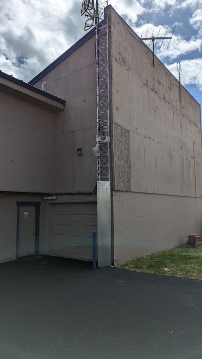
This is the USHCN station in Grants Pass, OR. Parking lots and air conditioners again.
The worst part? NOAA/NWS knows about it and doesn’t care. I received this comment on my Facebook page:
As the former Engineering Director there for 13 years I can say more than once when the Medford NWS office visited I asked if it could be moved to more suitable position. I even offered to do it. But the suggestion was always declined.
https://www.facebook.com/anthony.watts.chico/posts/5114537851927946?comment_id=5114579285257136
How can I help?
Well, it’s pretty simple, all you need is a cellphone (smartphone) and a web browser. If you really want to science it up, get a FLIR camera attachment for your phone.
Back in the day when I started the project, locating the stations was quite difficult. To NOAA’s credit, they have greatly improved the metadata for all surface stations an have a comprehensive database called the Historical Observing Metadata Repository (HOMR). In that database, you can find all the stations exact latitude/longitude, though they don’t give street address. Finding it on a map only requires Google Earth and dropping in the lat/lon values. Then you just drive there and look for it. Sometimes, you can even find them on Google Earth Street View.
So, I’m asking that wherever you live, you choose a station or two from the list below near you, announce it here in comments (to prevent doubling up), and follow the procedure I’ve listed below. Then post your photographs and description here, as well as emailing them as a zip file to me for inclusion in the database.
Here is the list of stations and their locations that I need to examine before the end of May 2022. These stations were included in my 2009 report IS THE U.S. SURFACE TEMPERATURE RECORD RELIABLE? Stations with line through them have either been closed or I have already surveyed them or plan to survey them. I have helpfully included a link to each one to the HOMR database that shows location. I’ve also included some notes on each station. You can see original photos of these stations in the original report in 2009.
Please see the procedure after the list on how to find and photograph them today.Amherst, MA – Sewage Treatment Plant, 1 Mullins Way Amherst, MA 01002 GE LinkArdmore, OK – CLOSED 2009 for temperature reporting due to horrible siting on street GE LinkAshland, OR – Sewage Treatment Plant, 1295 Oak St, Ashland, OR 97520 GE LINK
Atchison, KS – Benedictine College, 1020 N 2nd St, may be in courtyard GE LINK Baltimore, MD – CLOSED for temperature reporting due to horrible siting on roof.Bainbridge, GA – CLOSED 2010, sensor 8′ from road and A/C unit
Bartow, FL – Previously at P.D., sensor right on the street, MOVED. GE LINK Street ViewBlacksburg, VA Located at NWS Office, 1750 Forecast Drive, in the rear GE LINK Street ViewBlock Island, RI – Original Report showed ASOS, HOMR element data shows a CRS, Find it please.
Brinkley, AR – Sewage Treatment Plant, 1185 Rusher Dr, Brinkley, AR 72021 GE LinkBrookville, IN – Brookville Water Works on Driveway, 898 Cliff St, Brookville, Indiana GE LINKBuffalo Bill Dam, WY – May not be at vistor center, 4808 N Fork Hwy, Cody, WY 82414 GE LinkBunkie, LA – Surveyed already Sewage Treatment Plant. GE Street View LinkChampion, MI – CLOSED in 2011 due to location near parking lot. GE Street view Link
Clarksville, TN – at the WWTP off Quarry Rd. Lots of construction since original survey. GE LinkConway, SC – CLOSED, fire station closed, no new observer found.Cornwall, VT – 2900 Seth Warner Memorial Hwy (private residence, visible from road) GE Street View Link
Crosby, ND – 209 1st Ave NW, Crosby, ND 58730 (private residence, visible from road) GE LinkDayton, WA – Sewage Treatment Plant, Stockton Rd. GE Link
Detroit Lakes, MN – At KLDM radio, (moved 70′ west) 1060 Richwood Rd, Detroit Lakes, MN – GE LinkDillon, MT – Surveyed by A. Watts April 2022 Right next to campus generator bld, above sidewal – GE LINKDrain, OR – Surveyed already – A. Watts Sewage Treatment Plant, Division Ave, Drain, OR GE LinkDurham, NH – US Forest Service, W End Path, 271 Mast Rd, Durham, NH 03824 GE Link
Ennis, MT – Rainbow Valley Lodge, Hwy 287, Ennis MT GE Link
Enosburg Falls, VT Looks to be on a farm, 27-1 Birch Ln Enosburg Falls, VT GE LINKFalls Village, CT – CLOSED – went to automated SCADA data?Fort Morgan, CO – MOVED in 2017 and 2018. May now be at private residence. GE LINK
Fort Scott, KS – MOVED 2013 from Funderal Home to PRIVATE RESIDENCE – 1904 S. Margrave St, GE LINKGainesville, GA – Observer died in 2021, station disposition uncertain, 955 Sunset Blvd. GE Street ViewGrace, Idaho – Surveyed by A. Watts April 2022, over concrete, bizarre placment of MMTS. GE LinkGreenville, TX – Surveyed already.Greenwood, DE CLOSED – Unknown reason GE LinkGunnison, CO – At Gunnison County Electric Association near maintenance. GE Link GE Street ViewHaskell, TX – Moved from radio station, at private residence now. 900 N 8th St, GE Link GE Street View Hay Springs, NE – CLOSED in 2018, directly next to building. GE Link GE Street ViewHendersonville, NC – Still at WKHP radio next to satellite dish, road. GE LINK GE Street View
Heppner, OR – Looks to be right on the street, at oil facility. 776-650 Riverside Ave. Heppner, OR GE LinkHillsdale, MI – At Wastewater Treatment Plant. W Galloway Dr, Hillsdale, GE LinkHopkinsville, KY – Moved 2020 from ridiculous location at BBQ/AC 302 Briarwood Dr. GE Street View LinkHot Springs, SD – Looks to be next to parking lot, 501-599 N 5th St, Hot Springs, SD GE Link
Kennebec, SD – Looks to be in yard near garden, visible from 2nd street GE LinkLampasas, Texas CLOSED 2013 for temperature reporting due to horrible siting on street GE Street View
Lebanon, MO – At KJEL-FM next to parking lot. 18553 Gentry Road, Lebanon, MO GE LinkLenoir, NC – On the sidewalk at City Municipal Bld. 605 Harper Ave. GE link GE Street View
Lexington, VA -Looks to be at residence at 298-126 Walker St. GE LinkLogan, IA – at Sewage Treatment plant, CLOSED in 2021, Lovelock, NV – Already surveyed.Marengo, IL – Sewage Treatment 1400 N State St CLOSED in 2019, equipment may still be there. GE LinkMarysville, CA Terrible location. CLOSED. Removed from service. Miami, AZ – Terrible location. CLOSED. Removed from service due to “data default” in 2008. Midland, MI – Sewage Treatment Plant, Kent Ct. Midland. Sensor recently moved. GE Link
Milwaukee, WI Sewage Treatment Plant, 501 Sentry Dr. Wakesha, GE Link
Mohonk Lake, NY Huguenot Dr New Paltz, NY GE Link
Monticello, MS – Municipal Bldg. 317 Main St. GE Link GE Street View
Morrison, IL – Sewage Treatment Plant, 503 W Winfield St. Near SW fence border? GE Link
Mount Vernon, IN – Municpal Bldg. College and Water St. GE LinkNapoleon, OH – CLOSED, Sewage Plant, terrible siting GE LinkNeosho, MO at Neosho National Fish Hatchery 700 E, McKinney GE Link GE Street ViewNorthfield, VT – CLOSED, Sewage plant, observer quit, GE LinkOkemah, OK – CLOSED, unlocatableOrangeburg, SC – Sewage treatment plant, 395 Seaboard St NW, GE LINKOrland, CA – Surveyed by A. Watts May 2022, still a good station. GE LINKOrono, ME – CLOSED 2008, ridiculous siting on roof of steam generator plant. GE LINK GE Street ViewPanguitch, UT – Moved 2009 and in 2022, near house with watered lawn. GE Street ViewParis, IL – Sewage Plant, Near S. Fence 50’s of road and sewage tank GE Link GE Street ViewPaso Robles, CA – terrible siting at the off-ramp for Highway 101 over concrete, still open. GE Street View
Pocahontas, AR – Residence, 106 E. Wiley St. GE Link GE Street ViewRacine, WI Sewage Treatment Plant, 417 21st St. In front of office near parking. GE Link
Red Cloud, NE – City Garage? 763 US-281, looks to be on W side rear of building. GE Link
Assumption Richardton Abbey, ND – 418 3rd Ave W, could be at maintenance bldg. GE LinkRock Rapids, IA – Municipal Bldg. Between Street and Parking lot. GE Link GE Street ViewSalisbury, MD – CLOSED 2011, Sewage Treatment Plant GE Street View
Sandpoint, ID Formerly Ag Exp. Station, now at Airport Granite Aviation 2099 Industrial Dr, appears to be next to tarmac. GE Link GE Street ViewSanta Rosa, NM CLOSED, terrible siting in observers backyard. GE Link
Searchlight, NV – Highway maintence facility, 320 NV-164, changed to MMTS 2011. GE Link Street ViewSpanish Fork, UT Electric Substation, 2129 E. Powerhouse Rd. behind office near concrete wall? GE LinkSpooner, WI – Ag Research Station, out front. GE Link GE Street View.
St. George, UT – MOVED 2015 to private residence, original was sited in parking lot. GE LinkSt. Joseph, LA – Already surveyed.State College, PA Unchanged from 2008, CRS behind Walker science building on grass GE LINKStaunton, VA – Unchanged from survey in 2009, GE LINKTarboro, NC – Sewage treatment plant, unchanged from 2008. GE LINKThompson, UT – behind Utah Welcome Center off I-70 GE LinkTifton, GA – Still next to sidewalk, A/C units, road at WWTP. GE LINKTitusville, FL – Sewage treament plant 1205 Buffalo Rd, sensor may be moved GE LinkTroy, AL – Appears to be at Troy Univ. Downtown. 63 S. Court Square. May be on roof or in rear. GE LinkTroy Locks/Dam, NY – Appears to be near parking lot of admin bldg. GE LinkTuckerton, NJ – CLOSED 2010 reason unknown, previously at residence.Tucson, Ariz. – CLOSED. 2008 due to ridiculous siting in the parking lot. GE Street View LinkTularosa, NM – CLOSED. 2019 due to lack of observer interest.
Tullahoma, TN – Unchanged from 2008, at sewage plant between transformers & concrete. GE LINKUniontown, PA – CLOSED 2019 Sewage Treatment plant, “NOT INTERESTED IN THE PROGRAM.”
The Procedure:
- Locate a station near you from the list above
- Make plans to visit. Leave a note in comments below to avoid duplication. Note that government locations, such as sewage treament plants oftn have locked gates on weekends
- When visiting, note that temperature sensor may not be near rain gauge. Look for MMTS or Stevenson Screen, also called a Cotton Region Shelter (CRS).
- Take a smartphone and/or camera with you. You may want to preload the address into maps.
- If using a smartphone, ALWAYS turn the phone/camera horizontal to take pictures
- If possible take pictures from 20 feet away looking at temperature sensor from 4 cardinal compass points, plus one or two overall photos (wide view) to show what is near it from different angles.
- Be respectful of tressaping signs etc. Often you can get pictures through and/or above fences.
- Post note in comments that you have it, I will contact you by email to have you email photos directly.
- Deadline: May 29th, 2022
BONUS ROUND:
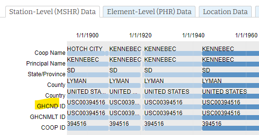
The list above is the USHCN, but there are many other stations that are part of the Cooperative Observers Network that are also used to observe temperature for climate data. These are part of the “A” network and contain a GHCN ID to indicate they are part of the Global Historical Climatology Network.
May of these stations don’t adhere to the 100 foot rule NOAA specification seen here.

You can find that designtion in the HOMR database under the Station-Level tab, seen below.
These are used in homogenization processes and for infilling missing data. There are many more of these stations that the USHCN we originally looked at. Here is how to find them.
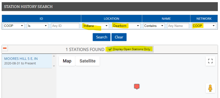
- Open up the HOMR web page and use the selector to choose where you live, such as state and county.
- Make sure you choose “COOP” in the right hand NETWORK selector, and then click on the “Display Open Stations Only” checkbox.
- The result will look something like this:
Click on the red balloon in the map, and you’ll then see another map below it with a blue square, click on it to get the lat/lon data:
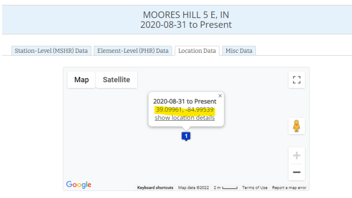
Paste the lat/lon data into google Earth (I use the downloadable program but the website version also works.)
Use the Google Earth Street view tools to locate the address, if it is a residence, use caution or select another station. Many stations are also on public facilities.
Can’t do any of this but want to help? Consider a donation to support the work.
THANK YOU – Anthony
Anthony…great to see you carrying on this important work. It was what got me hooked on WUWT all those years ago and revealed the true extent of the scam they were pushing. Many thanks for your ongoing efforts.
good
The meteorological authorities have absolutely no interest in correcting the faults in the surface stations as they are supplying them with the false readings that suit their political purpose. Accuracy and Truth are not their aim.
They always let me know if something is not right with my coop site. They are very interested in accuracy and good data. If you don’t believe me, try operating a coop site yourself and see if your assertion is true.
Another thing that has changed is that the NCDC (National Climatic Data Center)
is now NCEI (National Centers for Environmental Information):
It’s still a frustrating experience to find any data at the NCEI.
I can pick up Barstow on the 20th.
Well, that won’t help. I gotta get new glasses. It’s a long way from Los Angeles to Florida.
I think I’ll be getting that one.
How about a nice direct link to the list of stations?
And one to the HOMR web page?
just to make it easier on us old folks
These comments shouldn’t be under my comment! However,
https://www.ncei.noaa.gov/access/homr/
I didn’t use it last night, Lessee, for “my” Durham station, the USHCN list says:
USH00272174 43.1500 -70.9500 24.4 NH DURHAM —— —— —— +5
There’s no header line with field names. There’s a layout file that confirms that the +5 is the timezone. Note it still has low resolution lat/long.
Oh, the search function is the thing to use, it’s not very intuitive. Neither are the results. The attached image shows a search that worked, and how I used the zoom/scrollbar below the information to extract just recent stuff. I clicked the little dot for relocations, and umm, it may indeed have been moved to a better, but not great, spot.
Thats all in the post. Every station has a direct link in its city/state name, and the link to HOMR for that station is that link.
Thanks.
It would be great to see a full article here about how to access that data. I prefer to get it directly from tthe official source, to avoid arguments about truth. I know KNMI is good, but indirect. In 2014 I downloaded all data from Ashland, OR for analysis, from NCDC. I tried to update that analysis from NCEI a few years ago, and I was unable to get the same data. It seems they redesigned the user interface to make it nearly impossible to get a full set of data. By that I mean temperature readings at daily and/or monthly timescales, RAW and TOBS corrected data, precipitation, etc. with start and stop dates. In 2014, I found major adjustments had been done to data going back 100 years and more, like 10 degree adjustments. And the metadata changes did not correspond to the adjustments.
I can do the Durham NH site. There are a pair of CRN stations in Durham I might be able to visit, they’re at different farms and not close to paved roads and all that. Do we have any tools for comparing CRN and USHCN data?
Thanks Ric
I’m in Boston so if you can’t get to these let me know and I’ll try to get up Portsmouth way.
I got ’em today, thanks for the offer.
Anthony
I went to the NWS coop link and when I clicked on daily temps I received the message “Server Not Found.”
“Hmm. We’re having trouble finding that site.
We can’t connect to the server at http://www.weather.gov. ”
Getting this a lot …
There is the matter that the US Climate Reference Network of especially good surface stations has warming rate close enough to the same as that of USHCN (US Historical Climate Network). This indicates that poorly situated USHCN stations are overall not getting worse over time. The few USHCN stations that are affectable by air conditioner exhaust would have heating from air conditioner exhaust decreasing as old air conditioners are replaced by more-energy-efficient newer ones that use less electricity and produce less heat, and this would offset the effect of some other USHCN stations being in growing urban heat islands. For that matter, haven’t lots of urban areas increased their presence of trees in the past couple decades?
No, it shows that nClimDiv is being adjusted to match USCRN.
USCRN is controlling nClimDiv.
Just imagine the egg on the face if they let nClimDiv climb while USCRN stayed level.
I haven’t followed all this very closely for the past few years, but one of the hallmarks NASA/GISS adjustments to the temperature is cooling past temperatures. While it’s annoying seeing so few CRN references in current reports, it may well be that the CRN is influencing the the more numerous nClimDiv staions, as b.nice states.
I think that what you are missing is that most of the heat that comes off the outside heat-exchanger is heat being removed from the inside of the building.
I’m not sure what your point is, but note it takes energy to run a heat pump, so when the unit is cooling, then the exhaust is both the heat from indoors (from the whole building) plus waste heat expended to run the heat pump.
My point is that I think that the heat being removed from the building is much larger than the heat produced by the motor.
I was in particular taking exception to Klipstein’s remark, “The few USHCN stations that are affectable by air conditioner exhaust would have heating from air conditioner exhaust decreasing as old air conditioners are replaced by more-energy-efficient newer ones that use less electricity and produce less heat, …”
I may well be wrong about this, but it is my understanding that modern legal refrigerants are not as effective as the older CFCs and there may be no real gain in finding other ways of making the heat pump more efficient. In any case, I think that his assumption that modern heat pumps produce less waste heat needs to be verified.
Whatever the efficiency of the heat pumps over time, it still remains that the majority of the heat load is going to be what is removed from the building, never the “overhead” for the equipment.
It won’t matter if the station is moved away from any artificial heat source. That should be the standard.
Clyde Spencer, you are correct.
And concentrated by the exhaust/condenser fan directed toward the station.
A heat map will show the temperature gradient which should be at ambient near 100 ft distance.
It can easily be 2-3 degrees C hotter near the unit/exhaust than properly sited.
You’re not actually trying to argue that because the heat is from inside the house that improperly sited stations are actually measuring realistic temperatures? Are you?
When your car is parked in a parking lot, it’s absorbing the heat from the Sun like the rest of the surrounding area. Yet, we all know the temperature gauge on our dash will read 105° until we start drivin. Then it settles to the surrounding ambient temperature.
Is it 105° outside or is it 90°?
As for the Figure 1 1979-2008 graph: I noticed NOAA having a warming rate more than that of 3 worst classes of stations, which is more than that of the best 2 classes of stations.
I see time range being selected for cherrypicking.
Also, I wonder about stations being considered as the same station when they’re moved farther out of town. And, for better fair reporting, I ask for comparison between USHCN and USCRN over the time period so far when both exist.
Hey, I think we have a volunteer!
Anthony, what time frame are you looking for? I could do Paso Robles CA in late July.
Yeah I need it by the end of May, but I can work with the Google street view for now. You can get it on your own time frame and I’ll update the database.
Give em hell!
A note abut the FLIR camera adapters: you need to ensure that you charge them regularly. There are reports of the attachment’s batteries going flat and recharging anymore.
An alternative is getting a CAT S62 Pro phone that has a FLIR camera built-in. It is twice the cost of the adapter, but it has 160×220 pixels instead of 80×60, has more than twice the sensitivity 70 mK instead of 150 mK, and is integrated in to the phone, so guaranteed to work without software issues. I have one myself for 18 months now.
By the way, the frame rate of these cameras is limited to 9 fps because otherwise they fall under ITAR restrictions for military equipment.
Do’h, that should be 160×120 pixels, not 160×220
Funny France stopped cheese exports as a punishment for Crimea (not camembert for you dirty Russians, that will teach you not to attack Ukraine), but until recently France was exporting FLIR for military use to Russia.
But French citizens can only own FLIR sold without attachment, consuming one hand. Can’t have those on your head, dirty French civilians!
“ITAR restrictions for military equipment”
Do these Stinger missiles have reusable FLIR ranging modules, or is it 100% guaranteed tamper proof and only usable to shot down planes?
How many were sent?
To whom?
What are the chances all are recovered?
Do they expire?
Can they be remote killed like Tesla and Deere?
“National USHCN monthly temperature updates have been discontinued.”
ftp://ftp.ncdc.noaa.gov/pub/data/ushcn/v2.5/
Looks up to date to me.
nClimDiv is also deliberately matched to USCRN.
USCRN has brought US temperature adjustments under control.
Basically ignore anything before USCRN and being non-data.
Greetings Anthony
I can handle Tifton, GA early next week although I don’t have a FLR attachment (looks like a neat gadget though)
No worries on the FLIR, just do what you can. Thanks.
Survey completed yesterday. Let me know what to do with the photos.
email sent to you
In 2019, I bought a bottom-of-the line thermal camera for my Pixels 3, “PerfectPrime IR0102 Thermal Imager for Android Cell Phones, -4-572°F, 9 Hz” see https://www.amazon.com/gp/product/B07FF8RD14/ .
It runs off the camera’s battery, and is a heavy load, even when the app isn’t running, requires that I take the camera out of it’s case, I have to reset the visual/IR alignment every time I start the phone if I want photos worth sharing, and has a remarkable 30×30 pixel array.
They have a better, cheaper model now, see https://www.amazon.com/dp/B08R93WZ6H/?th=1
It paid for itself diagnosing a frozen water in my well room. I thought the block was near floor level, it was where the porch/well room met the original house near the ceiling, a gap lets cold outside flow right over the pipe.
It may have a stuck pixel now. It was a good introduction. If I were to do it again, I’d probably go with Anthony’s recommendation. The two cameras near each other are a big win, as are the adjustable USB connector and internal battery.
reading thru the list of sites i noticed that there are many located near sewage treatment plants. like the one near me in hillsdale mi. so lets see, the climate jackals measure air temperature near industrial facilities where heat is a by byproduct of a process. what smells worse, the sewage being treated or the sewage they create? hell, why don’t they just take readings from the cabin temperature devices in every auto in america. is it just me or is anyone else here starting to question this man caused climate change thingy.
You didn’t mention two things:
1) Sewage treatment requires energy to process stuff. Ultimately, it releases heat. Ditto the bacterial digestion going on.
2) A growing populating population multiplies the above heat release.
The sewage comes from heated homes, including the hot water used in showers/dish washers, travels underground, insulated from the ambient air temp, and then goes through the digesters at the treatment plant. The plants commonly flare off the methane that is produced, generating more heat. It may not be a lot of heat, but it adds to the temperature of the air probably at the precision level that is reported. Definitely not an ideal situation.
Here are your choices for explaining lack of quality control in temperature measurement systems under government mismanagement.
1) We’ve always done it this way
2) Senior management has a bias problem
3) The chain of decision command is not being investigated or reported on
4) “We don’t know what you’re talking about” deaf and dumb statement from headquarters
5) It might get stolen if it was not attached to the building with parking lots and government vehicles close by
6) Agendas come before local quality control efforts
Let’s see a copy of the siting manual for location and installation at government facilities. The work order completion report probably does not specify quality issues other than level mostly open location (in the distance beyond the building install site).
What could possibly go wrong?
Commander at Pearl Harbor relieved of his duties – HISTORY
Well, I’d help out, but given the siting preferences of officialdom, there probably isn’t a station within 30 miles of me. I live in a hilly, wooded countryside area, so I’m sure there are no stations; they would distort their data too much. Well, maybe within 30 miles, at an airport. The Temps reported by the local news from the airport are usually about 10 degrees hotter than I read. I’ll look, probably sited on the tarmac.
Has anyone made parallel stations close to the offending UHI stations? If so, a few links would be appreciated as to how it went and what the difficulties will be.
This entire topic is ghoulishly fascinating – like a good horror movie
I have been doing Urban Heat Island work for the the last few years. I created a website containing my results, which you might find interesting.
http://www.urbanhi.net/pdsi.html
http://www.urbanhi.net
Next question. Do any environmental students know anything about these issues much less UHI?
No they don’t. Their just taught about the impacts of human development, ironically never realizing that that same development has irretrievably polluted the surface temperature record, and all of the gimmicks the computer nerds employ to “homogenize” the temperature record just spread the pollution around.
This reminds me of the way the government eliminated the corruption that was rife in the Bureau of Internal Revenue back in the early 1950s. They changed the name to Internal Revenue Service! That fixed it!
Is it just me or does I.R.S. sound more threatening than B.I.R?
Anytime the government starts calling any of its branches or agencies a “service,” start worrying.
I’ll check on Ashland , OR. I have a FLIR camera.
I can do state College.
I got some pics.
look for something in your email
You beat me to it. Given my photography skill level, though, that’s probably for the best.
An excellent idea. I was pleased to send funds for the first study and still have the little ‘prospectus’ report on the project. May I suggest you contact colleagues in Europe and and around the world to encourage a global project (locally managed of course).
I recall mentioning the idea should also be expanded to include other climate metrics, so that climateers don’t have a monopoly on the data, its manipulation, conclusions AND policy prescriptions.
What would be great, would be counter-reports like Jen. Marohasy’s work on the GBR and Susan Crockford’s on the health and numbers of polar bears, walruses, seals. They could use help and funds to run pograms, fielding grad students to count bears, dive on the largest coral reef in the world! ETC.
I also think it possible to undo the vandalism massively done, and continuing to be done by climateers on global station temperatures using a very simple statistic which I’ve demonstrated several times in comments:
The pattern of the raw temperatures of the US is faithfully repeated in the raw data of Canada, Greenland, Scandinavia, South Africa, Paraguay, Ecuador and even Australia (all had the record highs for the 20th century in the late 1930s, the great cooling that followed 1950s to 1979, 1990s highs and the Dreaded Pause). These patterns within a year or two corroborate each other as a global pattern.
This also is a bonafide discovery in climate science hidden by the vandalism of climate science for political and personal gain and celebrity. This is huge. It tells that climate changes such as the LIA and the other Holocene warm and cool periods were global phenomena occurring within a year or two around the globe! This tells us that a single high quality installation (perhaps a couple on each continent for security and redundancy) would be sufficient to provide a marker for any possible climate concern that may seem to require investigation. The hated tide gage network which underscores the lies of climateers estimating meters of SLR where it’s clear that in reality its inches is an example of what they are free up do with temperatures, coral or polar bears…
I would have difficulty getting to the temperature stations in the UK but I did do a bit of a search using the Met Office list of stations and Google Earth, along with their requirements for siting. The ones I looked at were all compromised, either by nearby roads or overhanging foliage – I’d be shocked if less than 95% were compromised in some way.
Here is the Gargle Maps location of the LA NOAA station in Oxnard. Nice of them to have that huge logo and “green” instrument field for easy identification.
https://tinyurl.com/ycksr4u5
Zoom out a few times to see every siting violation possible. Of note their immediate neighbors, east Mission Produce is a fruit/vegetable chilling plant, north Proctor & Gamble diaper manufacturing.
here is a photo of the actual site
Thanks Anthony. That’s one dirty Stevenson Screen.
Well that stinks.
O/T
– but –
Some of the folk you might be familiar with from the “climate crisis” space – “not for profits” etcetera…
2000 Mules
Link broken.