By P Gosselin on 12. September 2021
Norwegian data show September minimum Arctic sea ice has risen over the past 10 years, contradicting earlier predictions of a death spiral
By Kirye
and Pierre
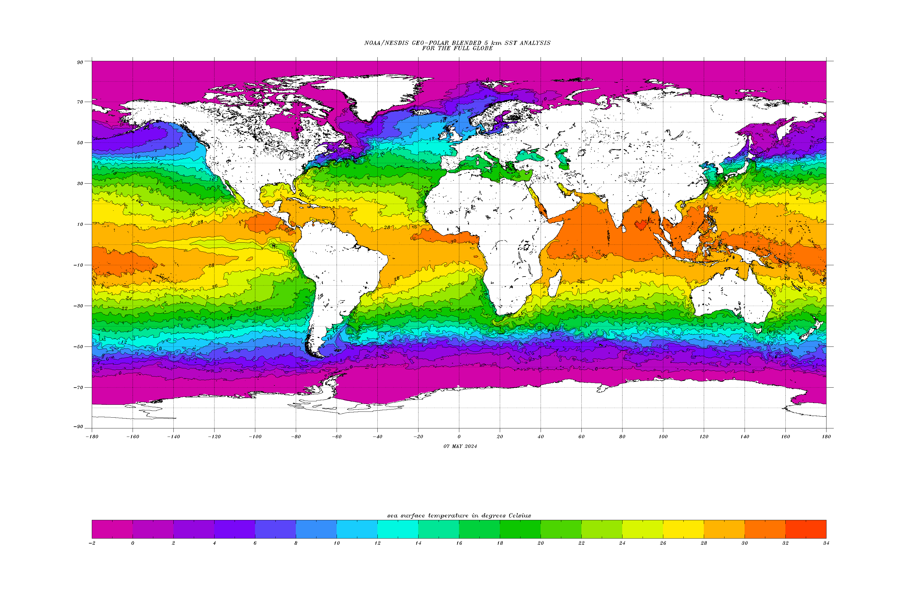
Friday NTZ posted on Arctic sea ice extent. This year Arctic sea ice has just about reached its minimum. and so we plot the new data (see below).
Substantial drop – since 1980
But first, of course there is no denying that September sea ice extent has has fallen substantially over the past 4 decades. Yet, those accusing us of cherry-picking also should read the entire article from last Friday, which shows the real cherry picking is done by the alarmists starting their charts in 1979, knowing full well there’s data going back far beyond that time point.
Again here’s Arctic sea ice volume going back 170 years:

Today’s sea ice volume is similar to that seen in the 1940s.
And as Tony Heller has shown dozens of times, the early 20th century is filled with newspaper clippings of a rapidly melting Arctic, which of course later refroze during the middle of the 2th century.
Rising trend
Now here’s osisaf.met.no data on annual minimum sea ice extent:

OSI Arctic sea ice minimum since 2012 ftp://osisaf.met.no/prod_test/ice/index/v2p1/nh/osisaf_nh_sie_daily.txt
September minimum trend has contradicted Al Gore’s predictions of an ice free Arctic. Whether sea ice has turned the corner and will start a recovery still remains to be seen. One thing is certain: The predictions of an ice-free Arctic soon made a decade ago were flat out wrong.
Norwegian data are wrong, they do not obey to the models.
Urgent NASAfication or NOAAfication of the Norwegian data needed!
I’m pretty sure if they were asked whether their data didn’t obey the models they would be surprised. But this is a “theory” you can falsify by asking them. Go for it, Joãozinho!
Your theory, your burden to ask for its falsification…
We have competing theories 🙂
More racism.
“More racism.”
Or a childish, sily process to try to be heard… The criter does not understand that data do not “obey” to models, it is the other way round: models MUST obey to data. I am pretty sure that Norwegian meteorologists and climatologists (and any person, Norwegian or not, with some scientific education) know that, so the sarcasm of my previous comment.
Yes—someone should ask nioci when the “perfect” UN models will solve the tropospheric hot spot problem and finally agree with actual data.
Models obey this data. There’s no contradiction. Any person with some scientific education understands that.
Have you some data (model outputs, for instance) to substantiate your assertion? Published papers, by you or others? I’ll be obliged if you show some references.
Yes, see above, eg. posts from Anthony Banton. References are also given there.
hum… good, sound scientific references, indeed!…
Like most progressives, nyolci has a deep seated hatred towards anyone who isn’t like him.
No. Correction: I have a deep seated contempt towards you 🙂
??? Kinda baffled.
Not to worry! The greentards will simply lie about it as they always do. They were on TV just yesterday lying about the climate on multiple “news” programs, in between their lies about Afghanistan and Chinese Disease.
New snow bomb on Greenland by Larry:
Yes, thanks for confirming GW physics – that warmer air carries more precipitable water.
Which at the top of the Greenland plateaux is snow.
Except that is for the first time in memory – earlier this summer.
How many times have people ever stood at the top of the greenland plateau let alone reported what was falling which was then recorded?
Inferred from the Tair and Tdp data … as it has been (presumably) at that auto Met station over the period that the NSIDC say that it has not been observed (obviously there are no human eyeballs there 24/7)….
http://nsidc.org/greenland-today/2021/08/rain-at-the-summit-of-greenland/
“On August 14, 2021, rain was observed at the highest point on the Greenland Ice Sheet for several hours, and air temperatures remained above freezing for about nine hours. This was the third time in less than a decade, and the latest date in the year on record, that the National Science Foundation’s Summit Station had above-freezing temperatures and wet s re is no previous report of rainfall at this location (72.58°N 38.46°W), which reaches 3,216 meters (10,551 feet) in elevation. Earlier melt events in the instrumental record occurred in 1995, 2012, and 2019; prior to those events, melting is inferred from ice cores to have been absent since an event in the late 1800s. The cause of the melting event that took place from August 14 to 16, 2021, was similar to the events that occurred this late July, where a strong low pressure center over Baffin Island and high air pressure southeast of Greenland conspired to push warm air and moisture rapidly from the south.”
It’s easy enough to observe remotely as a Tair Tdew both near 0C will be rain (though could be hail in v rare occasions) – simply check the data in met conditions conducive (warm sector of Tm origin).
http://nsidc.org/greenland-today/files/2021/08/GT_SummitRainAug2021_Fig2-1024×696.png
Figure 1b. The top graph shows 2-meter air temperature and dew point for Summit Station, Greenland, on August 14 and 15. The bottom graph shows air pressure at Summit during the melt event.
The Alps got a lot of snow in June, July, August and September, some places in NW and E Germay hat groundfrost in July, August and September. Should we be alarmed because of some raindrops in Greenland in August ?
Add.
In MWP you can be sure, it rained to – crop growing was possible.
No.
And I didn’t say we should.
It’s just an example of a weather extreme.
Also:
They have:
“x-band Doppler radar mounted on a 2-3m tall mast to measure reflectivity and mean Doppler velocity of detected hydrometeors to derive: precipitation occurrence, precipitation type, precipitation intensity”
https://geo-summit.org/instruments
And:
“Originally only occupied in the summer, the station has been staffed year-round since 2003, with a winter population of 4 to 5.”
https://en.wikipedia.org/wiki/Summit_Camp
We don’t need data, we have models.
This is confirmation of what computer models predicted days ago as a result of the remnants of Hurricane Larry.
It’s probably a good time to remind people of what this chart shows. It is only the surface mass balance (SMB). The total mass balance (M) also includes the discharge off the grounding line (D) such that M = SMB + D. See Mouginot 2019 for details.
Yes, I know, as others and I wrote about Larrys coming snow 😀
But as the total balance of mass is increasing….
That graphic isn’t showing the total mass balance.
No it’s not ….
http://polarportal.dk/fileadmin/polarportal/mass/Grace_combine_Sm_EN.png
“The map and graph show the gain in the mass of ice when there is precipitation, and how much of this mass is lost when snow and ice melt and when icebergs break off from the ice sheet’s major outlet glaciers. The difference in these mass changes over a glaciological year (September-August) is called the total mass balance of the Greenland Ice Sheet.”
http://polarportal.dk/en/greenland/mass-and-height-change/
Calving isn’t a result of climate change but a result of surface mass gain.
No, there is melt at the grounding-line, enhanced as a result of warmer waters and hence making for more frequent calving also.

Mass gain and it’s pressure is the reason for advancing glaciers to come in contact with possibly warmer water.
I see your clutching at straws again bamton glaciers and ice sheets calf because of the mass gain = pressure and movement ,when it snows the pressures builds up the ice sheets ,glaciers move towards the sea, every 5th year geography pupil knows that, ,your a desperate failed alleged weather forecaster banton .
First quit with the ad homs.
It’s not big or clever.
“I see your clutching at straws again bamton glaciers and ice sheets calf because of the mass gain = pressure”
Not solely.
If water meeting the glacier nose becomes warmer, are we agreed that it has the ability to create more melt (heck I hope so!) and given that it is not just local water, it is being fed in continuously from the ocean, then that melting ability is enhanced (yes?).
Now glaciers get anchored at their grounding-lines beneath the sea (surely you acknowledge that?)
And if/when the grounding line is eroded by melt then that will mean the anchor will ‘slip’ occasionally and cause the glacier to advance more quickly, then calve into the sea.
https://www.scientificamerican.com/article/why-are-glaciers-melting-from-the-bottom-its-complicated/
“Glaciers in Greenland and Antarctica are losing ice at alarming rates, and warmer air isn’t the only cause.
Scientists increasingly agree that warm ocean water is seeping beneath the ice and melting it from the bottom up.
It’s a growing problem in Greenland, scientists say, and it may already be the dominant driver of melting glaciers in Antarctica. But while scientists know that warm water is interacting with the ice front in both places, exactly what’s driving it there—and how climate change may be involved—is still an open question.
And:

https://www.science.org/doi/10.1126/sciadv.aba7282
Wrong again bant9n look at the arctic temperature graph its showing -10 all the way to the sea ice which is between -10 -2
Go to the web site and look for the 13,9,2021 its even cooler.
We aren’t discussing sea ice here. We’re talking about the portion of the glaciers that overhang the grounding line. Discharge occurs when the ice shelf calves, undermines from below, or straight up melts/evaporates. The Atlantification of the Arctic is warming the water and lowering the freezing point. This is probably playing some role in the increased discharge rate though other factors like surface melting and runoff may be contributing as well.
Yes we are read the post im replying to,the ice shelf discharges into the sea right, calves, the temperature is to cold for melt or evaporation ive just given the temperature graph that shows this, there is no increased discharge, there is discharge through calving the temperature plot shows the only way this is happening is because of mass build up.
There is increased discharge. See Mouginot 2019 which I linked to above. And based on the temperature plot you posted I’d say as much as 75% of the ice shelf is exposed to water greater than -2C at least July 28th, 2021 anyway. And finally SMB itself, though still positive, is declining so mass is not building up. It’s declining…a lot.
Glaciers on Greenland that we (at least I am) discussing are on the West and east side .
The colours show +ve temperatures right up the the coast.
Also warmer waters lie beneath the surface, as the north Atlantic drift waters cool coming north and being saltier than Arctic waters sink below……

It is actually the grounding line discharge (D) that is primarily responsible for Greenland’s total mass balance (M) decline.SMB is almost always positive on an annual basis (it only turns negative during the summer months). The grounding line discharge (D) is almost always negative. The total mass (M) was roughly balanced until 1980’ish when it started to decline. The decline has been accelerating as well. Warming waters and Altantification are undermining the ice shelves. Momentary increases in SMB cannot keep up with long term increases in the magnitude of D.
Text from article accompanying the image
“Arctic sea ice extent declined more slowly during August 2021 than most years in the past decade, and as a result, this year’s September minimum extent will likely be among the highest since 2007. “
So what we see is no linear loss of arctic ice ,as the warmests would have you believe,indeed the above quote accompanying the graph not one single warmest has bothered to quote.
Ice in the arctic is cyclical by season,, this year its lost a lot less during its summer melt which is normal ,summer melt is normal, so no emergency, no failure of the arctic sea ice as has been predicted for decades, its just not happening.
The leader of the free world, you know the guy that’s telling you global warming is killing every one, who believes that destroying his own energy generation and supply is a good thing for global warming.the guy global warmests look for inspiration 🤪
https://youtu.be/0hhzqNLvQxg
“How is that man dressing himself…” – that’s Taliban Joe Hiden Biden, the inspiration for thousands of climate kooks worldwide.
Its the black face mask its a dead giveaway all the psychopaths wear them ,they don’t think we notice 🤣 .
Seems like they have made the conclusion too early, the ice is still melting.
September 12th, the area was 5.42 million square km, that is on par with the 2013 minimum which occurred September 19. 2013.
The graph give a false impression that this year minimum is equal to the 2014 minimum.
It was equal September 10th, but it has melted a lot the last days.
/Jan
Climate Alarmists at NSIDC will only use the data from the satellite era, and that from only 1979 on and not rely on any other proxies from earlier decades. Why? Because 1979 – 2010 shows a major decline in summer sea ice extent.
But this decline is similar to what happened from 1920-1945. So do we have repeating natural variation or do we have a strong CO2 influence causing the latest decline?
With summer sea ice extent seeming to have bottomed out and slowly recovering, is this a repeat of the 1960’s and are we in for another “new ice age” scare?
Meanwhile, the Antarctic sea ice extent has been significantly above average since mid-June, much of that time outside (above) the interdecile range.
My point is that you certainly cannot draw the conclusion that we are heading for catastrophic polar ice melt from this data. It starting to look much more like cyclical repetition.
The last peak coincides with the 1975 fears of another ice age. Less of a problem after that. The graph tracks nicely the other events of the period. Great stuff.