Guest essay by Larry Hamlin
NOAA has updated its coastal tide gauge measurement data through year 2018 with this update now providing 30 years of actual data since the infamous 1988 Senate hearings that launched the U.S. climate alarmist political propaganda campaign.
In June of 1988 testimony was provided before Congress by various scientists, including NASA’s Dr. James Hansen, claiming that man made greenhouse gas emissions were responsible for increasing global temperatures with the New York Times reporting, “Global Warming Has Begun, Experts Tells Senate”.
The Times article noted that “The rise in global temperature is predicted to cause a thermal expansion of the oceans and to melt glaciers and polar ice, thus causing sea levels to rise by one to four feet by the middle of the next century. Scientists have already detected a slight rise in sea levels.”
NOAA has updated its extensive U.S. coastal tide gauge data measurement records to include data through year 2018. These measurements include tide gauge data coastal locations for 25 West Coast, Gulf Coast and East Coast states along the Pacific Ocean, Gulf of Mexico and Atlantic Ocean. In addition 7 Pacific island groups and 6 Atlantic island groups also have coastal location tide gauge data measurements updated as well.
In all more than 200 coastal locations are included in these measurements with more than 100 of these coastal locations with recorded data periods in excess of 50 years in duration. None of these updated NOAA tide gauge measurement data records show coastal location sea level rise acceleration occurring anywhere on the U.S. coasts or Pacific or Atlantic island groups.
Three decades after the politically driven speculation and conjecture offered at these 1988 Senate hearings NOAA tide gauge data fails to confirm or otherwise support these alarmist claims.
The latest updated NOAA coastal tide gauge measurement data shows locations likely to experience only inches of sea level rise by mid century (not one to four feet as climate alarmists speculated to Congress in 1998) with that increase consistent with long standing and unchanging rates of sea level rise measured at these coastal locations.
The longest NOAA tide gauge data record is at the Battery, New York with a 162 year long measurement period. This location along with all other NOAA U.S. coastal locations show no sea level rise acceleration occurring over the past 30 years despite scientifically flawed assertions otherwise by climate alarmists.


Dr. Judith Curry recently conducted an interview presented here at WUWT where she addressed the political drivers behind the climate alarmism campaign which distinguish it from being a genuine scientific endeavor. She offerred the following comments:
“Sea level is rising, but this has been gradually happening since the 1860s; we don’t yet observe any significant acceleration of this process in our time.” Here again, one must consider the possibility that the causes for rising sea levels are partly or mostly natural, which isn’t surprising, says Curry, for “climate change is a complex and poorly understood phenomenon, with so many processes involved.”
“Climatology is becoming an increasingly dubious science, serving a political project,” she complains. In other words, “the policy cart is leading the scientific horse”
NOAA’s coastal tide gauge measurement data are systematically ignored by climate alarmist propaganda campaign activists and media. That action represents a clear condemnation of any scientific validity regarding their efforts.
Not sure why It hasn’t been adjusted down like the “temperature” record. I mean the people reading the tide gauges back in the 20’s, 30’s and 40’s weren’t trained like those of today.
The current bit of deception is reporting satellite measurements of sea level rise, which are much higher than tide gauge measurements, grafting the two records together (shades of Mann), and reporting “acceleration”. If one gets down in the weeds, it is clearly an instrumentation artifact, so the advocates are being dishonest in not noting the reason for the change.
They would need to adjust the beginning of the record upwards bad the middle 1940’s downwards to create they impression of an increase
I am pretty handy with curve functions, graphics and programming. I can generate nice seal level plots which will show any desired amount of sea level and acceleration desired. Want 10 ft. of SLR by the year 2100? Easy!
Want to drown The Statue of Liberty? No Problem.
Also, my work is the highest quality. It will look every bit as good as anything that comes out of NASA GISS.
TonyL
Can you help with my bank balance?
Sure! happy to help.
No Problem!
If you get busted for felony fraud, not my concern.
I am not the person who did something wrong.
Payment in advance, please.
HotScot:
What is it worth to you if I do *not* report you for all your “indiscretions” ???
HotScot,
I can help you reduce it!
I’m concerned about dangerous numbers of loose seal levels. If the Democrats knew about those…oh boy!
Don’t put ideas into their heads.
My thoughts exactly.
I’m sure in time it will be. And the current data will disappear.
Please continue your valuable work Dr. Curry lots of us are watching, regardless of the radical activists that have usurped and corrupted the MSM.
Dr. Currys’ statement is the most mealy-mouthed drivel I can imagine. She says since 1860, as if it is a new phenomena. There are gauges around the world go back a lot further. All these gauges show one thing: Linear, Linear, Linear!
And they are linear going back to a time when AGW was simply not possible. This is *absolute* proof that AGW has 0.00 effect.
Yet Curry is willing to consider the possibility that it might be partly or mostly natural.
The contrary situation exists. This is the NULL hypothesis.
If anybody wants to assert AGW effects they need to prove it, not the other way around.
To provide proof, they must show that rates are accelerating. There are two ways they can do that:
1) Go to the data and demonstrate acceleration within the data record.
2) Manufacture the required trends as U. Colorado is attempting.
TonyL. Your insulting remark about Curry is totally uncalled for and you should apologise. She is a true scientist not a Hansen or a Mann.
She says since 1860 since there was sea level reduction before that and thus an acceleration to the current rise. There are not “a lot” of continuous records going back a lot further. It you have a broken record with probable location and equipment change it is of no use for long term assessments.
You know very little and are misinformed. I suggest you keep your “mealy-mouthed drivel” to yourself.
I stand by my comment.
There are some well sited gauges going back before 1880, there was no sea level reduction before that.
The problem is this:
Curry et al recently completed a project looking at SLR.
She knows better.
There are a very few european records going back before 1850. They indicate slightly decreasing sea-levels. The post-1850 records are remarkably linear. See for example Wismar:
Or Maasluis:
Curry is pointedly and deliberately being conservative about what she says and she refuses to engage in hyperbole . That does not make her “mealy-mouthed”, it makes her careful, correct, and credible. There has to be at least one adult in the room when facing the deliberate vengeance of the left.
@David Guy-Johnson:
I am a true scientist too:
No apologies, at all!
The reason we in this mess is that better people did not call out their colleagues for their bad behavior. Curry still can not or will not do that.
I stand firm!
As a scientist, I must present the facts, as I know them.
By the same token, I must condemn those who allow or promote misrepresentations of those facts.
Curry walks a fine line between the both.
She knows what she is doing. Why?
I believe that Dr. Curry is a true skeptic. She is even skeptical about skepticism.
Not every tide gauge is linear.
That’s the plot for Manila. In this case, there was a massive earthquake at the inflection point that clearly changed the geological dynamics of the area.
The sick thing is that the way people talk about the certainty of catastrophic sea level rise, EVERY tide gauge on Earth should look like Manila.
TonyL is, perhaps, unduly cruel to Curry, but he is right on the science.
There is NO data to support the AGW theory. Curry just wants to stay in the game by taking a luke warmer position as do many of the sometime heroes of skepticism.
The question is my mind is wether or not we strengthen our case by conceding that there is a human factor in climate when there is no data to support that claim.
I am not sure. The warmest have succeeded when our best skeptics, like Curry, concede “some” human factor. There is or there isn’t any human factor The null hypothesis has not been rejected by any data set on any climate variable I have seen so far.
I strongly support Curry’s efforts, but the question remains: if there is any human factor, harmful or helpful or neutral, where is it in the data? Where is the hockey stick? Show me, please. No hockey stick? then the null hypothesis stands
Wait, what? The graph must be wrong. We all know the seas stopped rising on 09 January 2009.
“We all know the seas stopped rising on 09 January 2009.”
True, but on 20 January 2017 the sea started rising again. NOAA just had to apply a little smoothing to the data to come up with the current graph.
Many thanks Larry,
Another great post on WUWT with real facts. It’s what makes WUWT great (still).
Isn’t the ratio aroun 2 to 1.
For every square kilometer of habitable land lost to sea level rise 2 sq km of habitable land is created, or free’d on rising continents and perma-frost melt.
Could be true but unfortunately we built our major cities right on the shore just feet above sea level…stupid humans
How many buildings last 50 or a 100 years?
If you fail to build new foundations six inches higher than the structure you replaced, you deserve to get flooded.
Tidal gauges measure the relative positions of sea level to land. So, the sea could be rising or the land could be subsiding. Have NOAA data determined if the relative rise is due to the former, the latter, or both?
https://stevengoddard.wordpress.com/2012/05/05/sea-level-isnt-rising-manhattan-is-sinking/
Each tide gauge is the result of both sea level rise and land movement. Because of this, tide gauges around the world show different rates. Most land movement can be considered to have constant rate over a century or more (excluding places where events such as earthquakes happen), so any change in the rate would be due to a change in the rate of sea level rise. While the tide gauges show different rates, none show any change (acceleration) in the rate going back to the earliest measurements.
Subsidence due to ground-water withdrawal or compaction are probably not constant over century time ranges, but isostatic abdjustments and tectonic movements normally are.
And the longest european records do suggest some acceleration around 1850, but none since.
Original claims about sea level rise predictions didn’t incorporate relative land movement, so were left out of the equation. Unfortunately those at Sonel wanted better kit to show what they were capable of and their sats are now able to show vertical (and horizontal) land movement. Worth a look at their site;
https://www.sonel.org/-Vertical-land-movement-estimate-.html?lang=en
This meant game over in terms of NOAA being able to ignore the effects of land height change but they don’t seem to have done any work on it yet. For example; the tide data at the Battery, is as is. That’s MSL over a period. If you want to know the effect of land subsidence you have to deduct it.
I think that sea level will be quietly dropped as a harbinger of doom as the evidence isn’t there. You can muck around with temperatures by applying “scientifically justified” adjustments, but with Sonel it’s hard to do the same with MSL – although attempts have been made…
I did mention in the Guardian at the time of the first predictions of massive SLR that sea levels at the Battery, both ends of the Panama Canal, Fort Dennison Sydney, etc all showed a historical slow steady rise, with no acceleration. I was told (as if they were quoting from the Bible) “that sea level rise is not equal all over the world!” I pointed out that if sea level was rising with the acceleration that was being proven, then at some point all those locations would have to reflect that rise – otherwise they’d be in water “trenches”, so when would they start to be affected. Silence from them.
It’s already been dropped. It was always the canary in the coal mine for global warming because it would have the most severe impact on humans. They’ll do what they always do. Move the goalpost as it suits them. Because they are loud and shrill they’ll continue to gain ground. Money and power are the goals, global warming is the vehicle to get them there. Logic has nothing to do with it.
It hasn’t been completely dropped. I was at a town hall type event with former President Obama last week (one of a crowd of about 10,000) and he explained to the audience that 3-4 billion people are likely to be displaced over the next 50 years due to sea level rise. In the same breath he explained that he’s a believer in science!
It’s not so much the actual rate of rise, Bruce, but the rate of change which is important.
Are tidal gauges showing a faster rate of rise than before? All the evidence suggests no.
Do these measurements include “Glacial Isostatic Adjustment”, like the published world sea level values? You know, how they just make up a “correction factor” of 0.3mm per year of sea level rise, call it a real thing, and then call these bastardized results “data”. Funny how these sorts of things never lower temperatures or sea levels. You’d almost think it’s an agenda of some kind…
From the U of Colorado’s Sea Level Research Group:
“Prior to release 2011_rel1, we did not account for GIA in estimates of the global mean sea level rate, but this correction is now scientifically well-understood and is applied to GMSL estimates by nearly all research groups around the world. Including the GIA correction has the effect of increasing previous estimates of the global mean sea level rate by 0.3 mm/yr.”
John,
The GIA adjustment to sea level is blatantly deceptive, unscientific and outrageous. It just infuriates me to see pal review in science allowing such travesties.
Not to mention other “adjustment” attempts like trying to “account for” the sea FLOOR sinking, you know, under the weight of all that extra (yet invisible) water.
In any event, if GIA and/or sinking sea floors offset sea “level” rise, then it all sounds like a non-problem, because only an increase in the RELATIVE sea level would cause any coastal flooding anyway!
Individual sites, e. g. around the Baltic are strongly affected by isostatic effects.
The Global isostatic corrections is extremelu dubious. They are usually based on the ICE-5G/6G GIA model which are well known to give drastically different results than actual GPS measurements for the most important area, Antarctica.
No sealevel rise acceleration.
Global temperatures are falling, not rising.
Extreme weather is decreasing, not increasing.
And on and on.
I looks to me like the CAGW hypothesis is falling apart.
Not fast enough. We only have 11 years, 10 months and 2 weeks left to save the world.
What? I thought we are 1 month and two weeks late to save the world.
I recall when in around 2000 Ted Dason proclaimed on TV that in 10 years the oceans would be uninhabitable.
To whom? Who lives in the oceans? I know what does but not who.
“Global temperatures are falling, not rising.”
What planet are you talking about? If you are going to at least sound reasonable you need to try to make sense. No one with any thread of understanding believes global temperatures are falling. They make all sorts of lame excuses for the increase…. but it aint falling.
Current temperatures are between 3c and 5c below the Holocene Climate Optimum

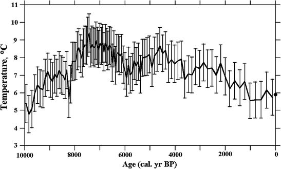

https://link.springer.com/chapter/10.1007/978-3-319-16006-1_2
These graphs are reconstructions of the Baltic Sea Basin and clearly indicate a 3 degree temperature dorm from the HCO.
And this graph is a reconstruction from the pollen data from a lake in south central Sweeden and shows a 3-4c dorm from the HCO.
Then this paper available in PNAS
https://www.pnas.org/content/114/23/5952
Also clearly indicates, from ice cores in Greenland a temperature during the HCO that are up to 5c higher than current
note: HCO is indicated from Low Resolution Proxy Data while the apparent current temperature “blade” is from high resolution thermometer data and doesn’t necessarily limit the HCO to just 5c above current. High resolution data is better indicative of potential spikes
There are numerous papers that indicate the existence of a HCO that was (by proxy data inferred temperatures) as much as 5c warmer than today and indicate a gradual fall off to today’s temperatures. The only reason for any “blade” on the end of the record is due to “Mike’s Nature Trick” of splicing High Resolution Thermometer Data onto the end of Low Resolution Proxy Data.
temperature
dormdrop from the HCO.I see you come from the planet where temperatures remain static. Let me guess, moon landings are fake and the globe is flat?
If you could provide some evidence to suggest mankinds CO2 output is warming the globe please share.
Yawn….
chrome-extension://oemmndcbldboiebfnladdacbdfmadadm/http://static.berkeleyearth.org/pdf/annual-with-forcing.pdf
So a drop in Temperature of >0.5C since 2016 which makes it currently cooler than 1998, 2004, 2007, 2013 as well as 2015 and 2016 is not Cooling?
I would consider that stable within the margin of error.
Simon, here’s the UAH satellite chart. See how the temperatures have fallen for the last three years since the Feb. 2016 highpoint? The global temperatures are falling. They haven’t fallen enough to change the trend yet, but they *are* falling, as can plainly be seen on the chart. CO2 I believe, is increasing, yet the temperatures are falling. CAGW says that’s not supposed to happen. It looks like CAGW might be wrong.
I see it looks like we have a little bit of an El Nino going on now. I suppose that will cause global temperatures to rise a bit in the future. The next few years will be interesting temperature-wise.
Tom
Oh so you are from the “every year should be warmer than the last otherwise it’s all nonsense” brigade. Go back and take a look at the graph you provided from RS. Only someone wilfully ignorant or being dishonest…. or both…. could not see that graph has an upward slope. Even Roy says we are warming.
Well, Simon, I won’t call you willfully ignorant or dishonest because you ignored my “The global temperatures are falling. They haven’t fallen enough to change the trend yet, but they *are* falling” comment. The truth is the temperatures fell from January to February. Falling.
Could you explain what is willfully ignorant or dishonest about that quote? I acknowledge the trend was still up, which is your point, but I’m also correct that current temperatures are falling. They might rise later, but currently they are falling. Nothing dishonest or willfully ignorant about it. What say you?
Tom
“Well, Simon, I won’t call you willfully ignorant or dishonest because you ignored my “The global temperatures are falling. ”
Because the fall is trivial and meaningless. March has started very hot…. But that’s meaningless too.
They haven’t fallen enough to change the trend yet, but they *are* falling” comment. The truth is the temperatures fell from January to February. Falling.”
So what?
“Could you explain what is willfully ignorant or dishonest about that quote? I acknowledge the trend was still up, which is your point, but I’m also correct that current temperatures are falling. ”
Long term global temps are up on all the major datasets including Roy Spencer’s. So any trickery with short term data is slippery and misleading.
“They might rise later, but currently they are falling. Nothing dishonest or willfully ignorant about it. What say you?”
I’ve said it above. But it depends whether you want to have your name beside something so misleading. I know I wouldn’t.
A hockey stick without a blade, scores ZERO goals. Better start fudging, er “smoothing” the data.
Simon, yes I know this troll well, and yes, it s willfully ignorant and dishonest as trolls tend to be. Poor stunted creatures. Brett
Brilliant come back…. now address the point I raised (the planet is warming not cooling), or you are admitting you have nothing to add.
Could you say how you determine there’s been no acceleration in the Battery data?
It shows an overall rate of 2.85 mm / year, yet the trend over the last 30 years is 4.36 mm / year.
About half of The Battery data rise is probably land subsidence. See PSMSL.org for both the gauge and GPS elevation data.
Also see “A Search fo Scale in Sea-Level Studies” Larson et. al, Journal of Coastal Research, July 2006. Larson concludes from US east coast basal peat records that sea level has been rising at a rate of about 1.3 to 2 mm/yr for the past 6,000 years.
Maybe so, but I’m not the one using the data as evidence there’s been no change in sea-level rise over the last 30 years.
There’s a big difference between using all of the data, vs a single cherry picked data point.
The head post claims there is no acceleration over the last 30 years, that’s why I used that period.
I see the same rate for the last 30 years as for the entire time, with noise but no significant deviation from the linear average line. The recent deviations are no different from those early in the 20th century.
You might “see” that, but have you tested any changes to see if they are significant or not?
Bellman,
Look at the chart. Looks to me like a linear rise in sea level. You might tease out acceleration with curve fitting but it would not be statistical significant. And DHR is correct that the land at The Battery is subsiding.
Being the skeptic, er “denier” that I am … I questioned the notion of subsidence at Battery Park. After all, I thought the solid underlying Manhattan were more like granite rock formations. So a quick bit of research … page 1 of Wikipedia … reveals:
Battery Park City is a mainly residential 92-acre (37 ha) planned community on the west side of the southern tip of the island of Manhattan in New York City. More than one-third of the development is parkland.[1] The land upon which it is built was created by land reclamation on the Hudson River using over 3 million cubic yards (2.3×10⁶ m3) of soil and rock excavated during the construction of the World Trade Center, the New York City Water Tunnel, and certain other construction projects, as well as from sand dredged from New York Harbor off Staten Island.
Battery Park = “reclaimed” land = prime candidate for subsidence. Please make note of it in Gore’s/Mann’s next Congressional testimony. And be sure to speak reallll slow … because AOC isn’t the brightest bulb in the room
“Look at the chart. Looks to me like a linear rise in sea level.”
The chart is pretty useless for determining how linear the rise is. Noisy monthly data displayed as lines is one of my pet peeves. But what I see from the chart is that much of monthly sea levels in the 2st century are above the tend line, whilst more of the data during the 80s were below the trend line.
“You might tease out acceleration with curve fitting but it would not be statistical significant.”
That’s a strong claim, have you done any calculations to confirm there is no statistically significant change?
Bellman,
Don’t need no fancy calculations, look at the noise in the signal and you know linear is just as likely as bent upwards. If you are trying to squeeze a scary story out sea level rise, you should pick a different location than The Battery.
“Don’t need no fancy calculations, look at the noise in the signal and you know linear is just as likely as bent upwards.”
If it’s obvious just by looking, then there should be no problem demonstrating it with “fancy calculations”.
” If you are trying to squeeze a scary story out sea level rise, you should pick a different location than The Battery.”
I’m not trying to squeeze out any story, scary or otherwise – just trying to establish is there’s any logic to the claim that there has been no acceleration in the data. I used Battery because that’s the gauge used in the post.
Take a look at the actual data:
https://tidesandcurrents.noaa.gov/sltrends/sltrends_station.shtml?id=8518750
The 95% confidence level lines are barely distinguishable.
“The relative sea level trend is 2.85 millimeters/year with a 95% confidence interval of +/- 0.09 mm/yr based on monthly mean sea level data from 1856 to 2018 which is equivalent to a change of 0.94 feet in 100 years”
And please note that the entire US east coast south of Cape Cod is sinking, something that is obvious from the coastal morphology. Barrier islands and drowned river valleys (rias) are typical features of such sinking coastlines. And they take time to form, so it has been going loooong before 1850.
“The 95% confidence level lines are barely distinguishable.”
Which tells you nothing about whether the trend is linear or not.
This does tell You about acceleration and retardation.
https://tidesandcurrents.noaa.gov/sltrends/sltrends_station.shtml?id=8518750
“Which tells you nothing about whether the trend is linear or not.”
?????????????
I take it that have never calculated the confidence levels for a line regression on markedly non-linear data?
Linear is only one kind of model, and it is quite possible to reduce the confidence interval using a different model, such as a quadratic.
Perhaps someone with the skill could test the data, and discover which model is the best fit. And calculate the confidence intervals.
Here’s one way to do it.
https://en.wikipedia.org/wiki/Akaike_information_criterion
For the claim in the top post, a simpler test would be to figure out the CI for the linear trend for the 30 years referenced in the top post: 1989 – 2018 (incl). Then see if there is overlap with the CI as given by NOAA for the whole period: 2.85 mm (+/- 0.09).
Results would not be conclusive, of course – formal statistical analysis is inherently probabilistic. But we’d get some numbers on the likelihood of acceleration or not.
“Could you say how you determine there’s been no acceleration in the Battery data?”
Any recent uptick in the data is due to the moons’ nodal precession, which varies on a multi-decadal time scale.
Personally, I follow Boston most closely, and the precession forms a beautiful sine wave with a period of 76.6 years. The expression of the precession does vary depending on where you are in the world. New York has to be similar to Boston because they are so close. The effect of the moons’ orbital nodes is very well understood by the tide gauge community, and is studiously ignored by the Global Warming community. Although the effect is well known, I have *never* seen it mentioned in any research coming from the CAGW/CC community.
I guess having the moons’ precession on an upswing since ~1975 showed what they wanted and was too good to pass up.
Question:
Where did that 4.36 mm/yr come from? seems a little high for the New York station?
Anyway here is Boston, showing linear and acceleration red and blue straight lines. Along with precession indicated by the curved lines.
https://postlmg.cc/crt7s0c5
“Any recent uptick in the data is due to the moons’ nodal precession, which varies on a multi-decadal time scale.”
The claim was that there was no change in the rate of sea level rise, now you ware saying there is but it’s caused by the moon’s nodal precession. Could you explain how the nodal precession cause a 76.6 year cycle in sea level rise, given that the nodal preccesion only lasts about 18.6 years?
“Where did that 4.36 mm/yr come from? seems a little high for the New York station?”
I calculated it directly from the data from the linked NOAA site. After posting I did wonder if seasonal changes might affect the result, so recalculated using annual averages and got pretty much the same result, 4.35mm / year from 1989 to 2018.
“Could you explain how the nodal precession cause a 76.6 year cycle in sea level rise, given that the nodal preccesion only lasts about 18.6 years?”
Nope!
I am not an orbital mechanics guy, nor am I a tide gauge guy. I do note this:
Nodal preccesion X apsidal precession = What we observe.
Dig into it, you will learn more about orbital mechanics than you ever wanted to know.
nodal preccesion X apsidal precession = What we observe.
18.6 X 8.0 / 2.0 = measured.
apsidal precession is 8.85 years, so your formula would give a measured cycle of 82.3 years. You claimed the observed cycle was 76.6 years.
You say that all this is very well understood in the tidal gauge community. Could you point me to anywhere where this is discussed on line?
@ Bellman:
I got the 8.0 figure from that paragon of accuracy, Wikipedia, a couple of years ago. I see they have changes it now. All I can do is take another look at the data.
We are still only looking at a ~7% change and only 1 full cycle.
References:
I have not found any good explanations of the effect, just statements of attribution. It seems among the tide gauge people, it is supposed to be common knowledge that everybody just knows. Not helpful.
There’s a difference between an increased rate and an acceleration. If while driving your car you change speeds from 40 to 50 mph, you’re only accelerating while you change speeds. If you were truly accelerating, your speed would be constantly increasing by some feet/second/second. the curve on the graph would look very different.
“There’s a difference between an increased rate and an acceleration.”
That’s literally what acceleration means, a change in the rate of change.
“… the curve on the graph would look very different.”
But even if there was no acceleration since 1990 there would still be more of a rise over this century than the post is suggesting.
And for last 9 years it has been around Zero.
Which shows that the last 50 years have been rising significantly faster than long term trend.
No, which means the rate is no different from 1910-1950. There is a multi decadal Oscillation and until a couple have been completed nothing can be deduced. Several papers have identified a 60 year Oscillation. Some authors suggest until 120 years for a location has been measured it doesn’t mean a thing.
Here is the Battery data compared to a number of NOAA “sea-leve scenarios”:
https://tidesandcurrents.noaa.gov/sltrends/sltrends_station.shtml?id=8518750
Note that the actual sea-level trend at the Battery is well below even the “low” scenario
There is no ‘scenario’ at the link to compare the data, which is what is actually shown at that link. Is there a missing link in your post?
NOAA never made a ‘scenario’ for individual stations. If you are referring to IPCC projections of sea level rise, these are always global, not local.
Bellman,
You do realize that your 30-year time frame includes the “super” El Niño of 1998 and two more recent El Niños (2010 and 2016, if I’m not mistaken). Ya think they might have some effect on the short-term trend that has nothing to do with CAGW?
Maybe, but as Bellman keeps pointing out, he is basing his work on exactly the same data that the top post based its conclusions on. Apples to apples, etc.
If there is a shortfall of information, it starts with the original post, which no one has called out for being short of information.
El Niños remove heat from the ocean, in which case their effect should be to ‘reduce’ sea level (by thermal contraction), not increase it.
“NOAA has updated its extensive U.S. coastal tide gauge data measurement records to include data through year 2018”
But doesn’t the slr hypothesis of agw relate to gmsl only?
The other question I have is that the slr issue may be better defined as whether it is driven by emissions and therefore whether it can be moderated with climate action; rather than whether the sea level is rising. Sea level rise in interglacials is the norm and not something unusual and unexpected that requires a causation explanatuon.
Reference #1
https://tambonthongchai.com/2019/02/20/csiroslr/
Reference #2
https://tambonthongchai.com/2018/12/05/attenuate-slr/
A consideration in the study of sea level rise is the complexity of ocean dynamics that creates spatial and temporal differences that are natural and therefore have no interpretation in terms of an external or artificial cause. Therefore care must be taken to identify the changes that can be attributed to AGW forcing (Sallenger, 2012). As described in the Sallenger paper, “Climate warming does not force sea-level rise (SLR) at the same rate everywhere. Rather, there are spatial variations of SLR superimposed on a global average rise. These variations are forced by dynamic processes arising from circulation and variations in temperature and/or salinity, and by static equilibrium processes arising from mass redistributions, changing gravity, and the Earth’s rotation and shape. These sea level variations form unique spatial and temporal patterns that are hard to predict” (Landerer, 2007) (Levermann, 2005) (Schleussner, 2011). Differences among the stations are understood in this context but long term differences in time in global mean sea level (GMSL) cannot be explained in terms of the natural phenomena described by Sallenger.
Who cares about 1988 lies presented to Congress? Lying became a way warmist’s life. It is business as usual.
Correct me if I am wrong since I am from mainland Europe and lying here is allowed and common practise. Isn’t testifying to Congress a sacred thing that by law you need to tell the truth or is that only in court? Even so if you are purposly trying to mislead people to alter money flow and laws then that in it self should be a crime.
Ex Oriente Lux.
If you are under oath, telling a lie is a crime. Both in court and before congress.
I don’t remember whether or not Hansen was sworn in that day in June 1988.
Assuming that the rise in sea level is due only by the expansion in volume from the temperature increase, how much has the temperature of the ocean increased?
Luckily, it is going to be real hard for alarmists in general over the long haul to adjust or fiddle with sea level rise since everyone near the ocean has a memory of where local sea level is. On the west coast from California to Alaska, I can’t personally tell there has been any sea level raise in 60+ years since I was a kid even though I know there has has been 5″ to 6″ according to the tide gauging stations which was normal before supposed AGW started.
Of course some of the locations globally may have different things going on like subsidence or rebound, and that would maybe confuse things. Just like it does in the reporting by alarmists of sea level rise in many cities like Shanghai, New Orleans, Manila or Venice. But that is the ground sinking for various reasons, and not entirely the sea level rise that has been fairly steady since 1860. And no acceleration of that level.
What we have to watch out for now is the constant reporting of these numerous populated cities sinking below the seas faster than any real sea level rise, since the alarmists will still try and pin AGW and CC on these cities misfortune. This is all a PR exercise now, and the damage that misreporting will do is enormous whether it is factual or not. It is sort of like reading the retraction of a salacious story of some headline event the previous day, when the majority of people will remember the headline event, and not the retraction.
I would think that the Pacific plate subduction under the North American plate would influence the observed sea level rise in California.
Come on guys, they just haven’t had time to lower the measurements of the past yet!
You have it sooo wrong! They need to *raise* the early past. That will put a curve in the data. Then they can show acceleration and SLR going UP, UP AND AWAY, Faster Than a Speeding Bullet, Able To Leap Tall Buildings in a Single Bound.
You know, like Superman.
Current temperatures are between 3c and 5c below the Holocene Climate Optimum


https://link.springer.com/chapter/10.1007/978-3-319-16006-1_2
These graphs are reconstructions of the Baltic Sea Basin and clearly indicate a 3 degree temperature drop from the HCO.
And this graph is a reconstruction from the pollen data from a lake in south central Sweeden and shows a 3-4c drop from the HCO.
Then this paper available in PNAS
https://www.pnas.org/content/114/23/5952
Also clearly indicates, from ice cores in Greenland a temperature during the HCO that are up to 5c higher than current
note: HCO is indicated from Low Resolution Proxy Data while the apparent current temperature “blade” is from high resolution thermometer data and doesn’t necessarily limit the HCO to just 5c above current. High resolution data is better indicative of potential spikes
There are numerous papers that indicate the existence of a HCO that was (by proxy data inferred temperatures) as much as 5c warmer than today and indicate a gradual fall off to today’s temperatures. The only reason for any “blade” on the end of the record is due to “Mike’s Nature Trick” of splicing High Resolution Thermometer Data onto the end of Low Resolution Proxy Data.
This is where people argue over insignificance. lol Hard to find a coastal city drowning in sea level rise. The same people who promote all the climate hysteria are building mansion estates on the sea shores with climate research monies they stole from tax payers.
The best way to see acceleration is to see the change during a long time.
The 50 Year graph is obviously the most reliable as it contains generations of measurements.
Here is one from Germany and the North sea:
https://tidesandcurrents.noaa.gov/sltrends/sltrends_station.shtml?plot=50yr&id=140-012
And one from the Baltic:
https://tidesandcurrents.noaa.gov/sltrends/sltrends_station.shtml?plot=50yr&id=120-022
Sinus waves on both.
“Sinus waves”
Snot right !!
In common usage, “sinus” usually refers to the paranasal sinuses
The mucus produced by your sinuses usually drains into your nose through small channels.
Whereas – A sine wave or sinusoid is a mathematical curve
Thanks for correction.
But You understand my English better than my Swedish.
You got the technical part of it anyhow!
Unless the planet starts to gain water from unexpected comets, I’m not worried.
The members of the climate crusade are not interested in science, they have their beliefs to guide them.
“In 2005, I had a conversation with Rajendra Pachauri, an Indian railway engineer, who remade himself into a climatologist and became director of the IPCC, which received the 2007 Nobel Peace Prize under his tenure. Pachauri told me, without embarrassment, that, at the UN, he recruited only climatologists convinced of the carbon-dioxide warming explanation, excluding all others. This extraordinary collusion today allows politicians and commentators to declare that “science says that” carbon dioxide is to blame for global warming, or that a “scientific consensus” exists on warming, implying that no further study is needed—something that makes zero sense on its face, as scientific research is not based on consensus but on contradictory views.”
https://www.city-journal.org/global-warming
HotScot March 5, 2019 at 11:39 pm
TonyL –
Can you help with my bank balance?
___________________________________________________
HotScot, nothing wrong with your bank balance.
Alan Greenspan, Bernie Madoff, Ben Bernanke, https://www.google.com/search?q=christine+lagarde&oq=cristine+laguard&aqs=chrome. won’t better you.
“This location along with all other NOAA U.S. coastal locations show no sea level rise acceleration occurring over the past 30 years despite scientifically flawed assertions otherwise by climate alarmists.”
Scientifically flawed?
Sea temps are rising.
Water expands when warmed.
The Earth is losing ice mass ( at lower levels ) as as average freezing levels rise, this outweighing increased snow deposition at higher levels due to increased atmospheric precipiatble water content.
http://sci-hub.tw/10.1002/2017GL072845
“Abstract The tide-gauge record from the North American East Coast reveals significant accelerations in
sea level starting in the late twentieth century. The estimated post-1990 accelerations range from near zero
to ∼0.3 mm yr−2. We find that the observed sea level acceleration is well modeled using several processes:
mass change in Greenland and Antarctica as measured by the Gravity Recovery and Climate Experiment
satellites; ocean dynamic and steric variability provided by the GECCO2 ocean synthesis; and the inverted
barometer effect. However, to achieve this fit requires estimation of an admittance for the dynamical and
steric contribution, possibly due to the coarse resolution of this analysis or to simplifications associated
with parameterization of bottom friction in the shallow coastal areas. The acceleration from ice loss alone
is equivalent to a regional sea level rise in one century of 0.2 m in the north and 0.75 m in the south of
this region.”
“We conclude that the North American
East Coast has recently experienced sea level acceleration due to combined AIS and GIS ice-mass loss only (that
is, without any ocean dynamic component) of 0.04–0.15 mm yr−2, depending on location. This acceleration
is equivalent—in a purely quantitative sense, i.e., with no implication for a specific future projection— to an
increase in sea level in one century of 0.2–0.75 m.”
“While an increasing number of studies highlighted multidecadal acceleration in sea level along the northeast coast of North America [Park and Sweet, 2015; Sweet and Park, 2014; Kenigson and Han, 2014; Ezer,
2013; Calafat et al., 2012; Kopp, 2013; Boon, 2012; Sallenger et al., 2012], those works interpret the changes
in sea level in terms of ocean dynamics only. Here we present the first model for the observed geographic
variability of eastern North American sea level acceleration that combines ocean dynamics (a term we will
take to include steric changes) with accelerated mass loss from Greenland and Antarctica, and the inverted
barometer (IB) effect.”
And globally ….
http://sci-hub.tw/10.1073/pnas.1717312115
“Satellite altimetry has shown that global mean sea level has been
rising at a rate of ∼3 ± 0.4 mm/y since 1993. Using the altimeter
record coupled with careful consideration of interannual and
decadal variability as well as potential instrument errors, we
show that this rate is accelerating at 0.084 ± 0.025 mm/y2, which
agrees well with climate model projections. If sea level continues
to change at this rate and acceleration, sea-level rise by 2100
(∼65 cm) will be more than double the amount if the rate was
constant at 3 mm/y.”
I do not know why you bothered with that last paragraph, everybody knows the Satellite Seal levels have been Corrupted by Adjusments.
As to the rest of it modelling all the way, the only 3 tide gauge graphs they show do not indicate any particular “acceleration”, one shows deceleration, the other 2 show recovery from reducing sea levels.
Where is the Graph for all Tide Gauges for the whole of the Northern US coast?
The claim is that the seas are warming. However the claimed warming is so far below the sensitivity of the instruments involved that nobody outside the Church of Global Warming takes it seriously.
Regardless, how much expansion do you expect a few thousandths of a degree to cause?
Is there a comparable record that goes back farther? As global temperatures fell from the 1940s to the 70s, should we have seen a decrease in acceleration or a decrease in global mean sea level during that time, per their theory?
My stab at this: Sea level rise (and greening, rising CO2, warming) is a function of the relatively smooth and steep rise out of a cold stadial period due to orbital mechanics that increased insolation. The fall back down is at the very least, 30,000 years in the future (when orbital mechanics begin a slow but eventually perfect position for a significant change in insolation) and even then it will be a jagged stuttering less steep fall.
Larry ==> Can you post the links to the data on which you’ve based your essay? I am not aware of a combined CONUS tide gauge measurement.
The Battery measurement is RELATIVE sea level — which is NOT the same as actual SLR (though only relative SLR is important for NYC).
The SLR graph for the Battery does not include the subsidence for the Battery, which is significant — in other words, the graph shows the ocean rising, but the land is sinking at the same time. All these tide graphs have this same fault — they do not show the sea rising — they show the combined effect of change is sea surface height and change in vertical position of whatever the tide gauge is attached to.
There are corrected sea levels measurements for some locations that have a “same structure, continuously operating GPS station”.
Tide gauges generally show more SLR than actually takes place, as most coastal locations have some subsidence, some have a lot (the outlier is much of the coast of Alaska – which is rising).
Look at the data from the CORS project. There is an international sea level measurement movement that is urging “same structure Continuous GPS” monitoring of enough tide gauges to allow us to know what is really going on with sea surface height.
Please see the following WUWT document which addresses a number of the issues you asked about. This document is listed in the references for this post.
There is much confusion about the different sea level rise estimates and data which this source addresses.
2015 Updated NOAA Tide Gauge Data Shows No Coastal Sea Level Rise Acceleration
Larry ==> I was hoping that there was some other source of data that leads to the conclusion that “None of these updated NOAA tide gauge measurement data records show coastal location sea level rise acceleration occurring anywhere on the U.S. coasts or Pacific or Atlantic island groups.”
Among the hundreds of tide gauges in NOAAs system, there are individual tide gauges that show anything you could every desire to see — acceleration, ‘deceleration’, rising falling, etc.
There are no averages of NOAA tide gauges because they all measure different things — things so different that an average would be a wasted effort — each measured RSL at that exact point — that exact tide gauge.
But of course, NOW they understand these things so much better that they can’t be held accountable for lies – sorry, ‘errors’ – they made thirty years ago – so we can safely disregard all that.
That was yesterday – can’t keep living in predictions from the past, y’know.
Where is there any consideration of the volumetric capacity of the ocean basin as one of the variables influencing sea level. ? Even at the speed of a growing fingernail tectonic plate movement changes the capacity of the basin, and hence sea level at least in the same order of magnitude as the millimeter or two of annual sea level variation from ice melt (net) or thermal expansion from minute temperature variations.
Working out the impact of tectonic movement is a collosal job. So, it hasn’t been calculated in any detail.
Movement would take place at plate junctions and if one side goes down, then the other end goes up. All the studies I’ve read that look at tectonic movement say that “overall” there’s no impact. That’s probably correct in the long term, but in the short term then it’s bound to have an impact. Look at east Africa which is drifting off eastwards at the rate of 6cm? a year and forming the great rift valley behind it. A few thousand miles length of continental shelf times a height of X hundred feet is a lot of water.
But, India’s still moving north and is that balancing the equation?
Teddz:
..”A few thousand miles length of continental shelf times a height of X hundred feet is a lot of water”……
It’ll be interesting to see the impact on MSL when the ‘dam breaks’ and the ocean
floods the rift. The Danakil depression is already over 100 metres below sea level in places.
“Where is there any consideration of the volumetric capacity of the ocean basin as one of the variables influencing sea level?”
http://sealevel.colorado.edu/content/what-glacial-isostatic-adjustment-gia-and-why-do-you-correct-it
Thanks barry,
As I suspected the article you reference confirms that the ocean basin is a variable but impossible to quantify!
Cheers
Mike
Can someone help? The sea rises and falls. How high it is at any one time or the maximum height in a year depend on temperature, wind, continental drift, earthquakes, volcanoes etc. etc. The deepest part of the ocean has only been measured to within several FEET accuracy, so how on earth can any sensible measurements be obtained?
Reminds me of an old Gilligan’s Island episode called “Quick, Before it Sinks”, season 2, episode 6.
Gilligan is setting lobster traps for food but unbeknownst to him the professor is using one of the traps to measure sea level. As the professor takes his daily measurements he discovers the island is sinking into the ocean. Once the professor realizes their island is doomed panic ensues. They resort to many plans in an attempt to stay alive as long as possible before the island sinks below the waves. (Sound similar?)
What they eventually discover is that Gilligan is moving this trap further and further out into deeper water each day to catch additional lobsters destroying the professor’s sinking island theory and calming their panic.
Man was the episode prescient.
https://www.dailymotion.com/video/x53q4b8
Tamino read the article and responded, but not here.
Instead they posted on their blog: https://tamino.wordpress.com/2019/03/06/sea-level-rise-sea-level-lies/
Look at this to lay waste to claimed measurements of 1 mm.
https://m.youtube.com/watch?v=q65O3qA0-n4
This is well worth your time. Only a very short interesting video!
Sea-level rise, shme-shmevel smive. That has to be the most absolutely boring & uninteresting of the the scare-mongered issues.