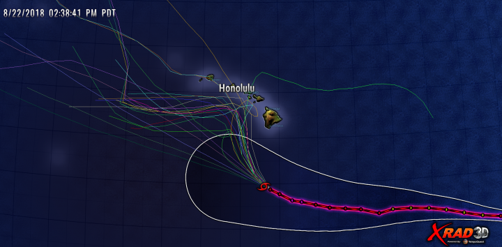
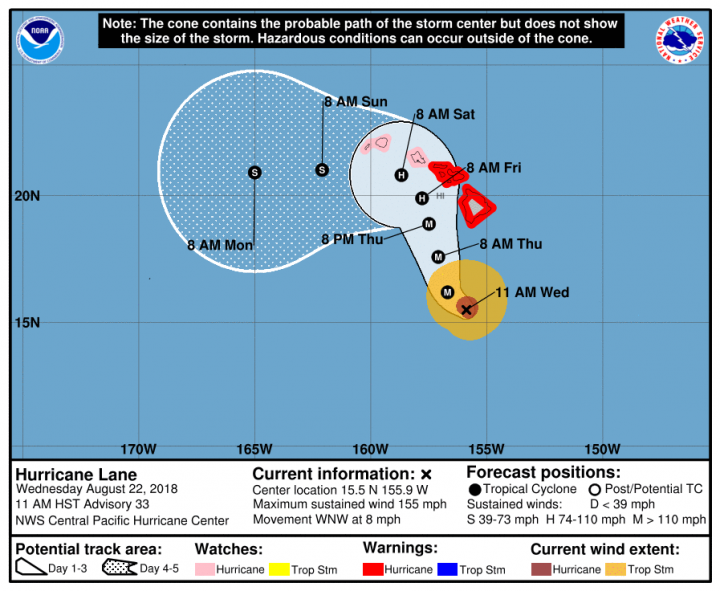
I’ve been watching this on my own analysis system, and I’ve noted that while ensemble model forecast tracks are literally “all over the map” the official forecast seems to suggest a near miss.
In the graphic above, we can see the wide view and the historical track of Hurricane Lane, now a CAT4 storm (after being CAT5 for awhile), with many tracks making a turn to the west.
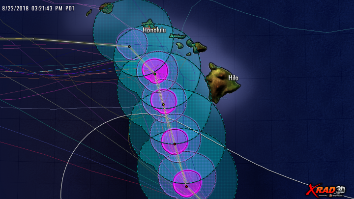
In the graphic below, the forecast radius of hurricane force winds are represented by magenta, and the tropical storm force winds in cyan.
Based on what I see, it looks like the Hawaiian Islands will get some measure of Tropical Storm force winds, while the hurricane strength winds will remain offshore.
Time will tell us more.
In the meantime here is the latest info:
BULLETIN
Hurricane Lane Advisory Number  33
NWS Central Pacific Hurricane Center Honolulu HI   EP142018
1100 AM HST Wed Aug 22 2018

...HAWAIIAN ISLANDS REMAIN VULNERABLE AS CATEGORY 4 HURRICANE
LANE PASSES SOUTH OF THE BIG ISLAND...


SUMMARY OF 1100 AM HST...2100 UTC...INFORMATION
-----------------------------------------------
LOCATION...15.5N 155.9W
ABOUT 285 MI...455 KM S OF KAILUA-KONA HAWAII
ABOUT 420 MI...680 KM SSE OF HONOLULU HAWAII
MAXIMUM SUSTAINED WINDS...155 MPH...250 KM/H
PRESENT MOVEMENT...WNW OR 295 DEGREES AT 8 MPH...13 KM/H
MINIMUM CENTRAL PRESSURE...935 MB...27.61 INCHES


WATCHES AND WARNINGS
--------------------
CHANGES WITH THIS ADVISORY:

None.

SUMMARY OF WATCHES AND WARNINGS IN EFFECT:

A Hurricane Warning is in effect for...
* Hawaii County
* Maui County...including the islands of Maui, Lanai, Molokai and
Kahoolawe

A Hurricane Watch is in effect for...
* Oahu
* Kauai County...including the islands of Kauai and Niihau

A Hurricane Warning means that hurricane conditions are expected
somewhere within the warning area. A warning is typically issued
36 hours before the anticipated first occurrence of tropical-storm-
force winds, conditions that make outside preparations difficult
or dangerous. Preparations to protect life and property should be
rushed to completion.

A Hurricane Watch means that hurricane conditions are possible
within the watch area. A watch is typically issued 48 hours before
the anticipated first occurrence of tropical-storm-force winds,
conditions that make outside preparations difficult or dangerous.

Interests in the the Northwestern Hawaiian Islands should monitor
the progress of Hurricane Lane.

For storm information specific to your area, please monitor
products issued by the National Weather Service office in
Honolulu Hawaii.


DISCUSSION AND OUTLOOK
----------------------
At 1100 AM HST (2100 UTC), the eye of Hurricane Lane was located
near latitude 15.5 North, longitude 155.9 West. Lane is moving
toward the west-northwest near 8 mph (13 km/h). A gradual turn
toward the northwest is expected today followed by a more northward
motion on Thursday. A turn back toward the west is expected on
Saturday. On the forecast track, the center of Lane will move very
close to or over the main Hawaiian Islands from Thursday through
Saturday.

Maximum sustained winds are near 155 mph (250 km/h) with higher
gusts.  Lane is a category 4 hurricane on the Saffir-Simpson
Hurricane Wind Scale. A steady weakening trend is forecast to begin
today, but Lane is expected to remain a dangerous hurricane as it
approaches the islands.

Hurricane-force winds extend outward up to 40 miles (65 km) from the
center and tropical-storm-force winds extend outward up to 140 miles
(220 km).

The estimated minimum central pressure is 935 mb (27.61 inches).
UPDATE:
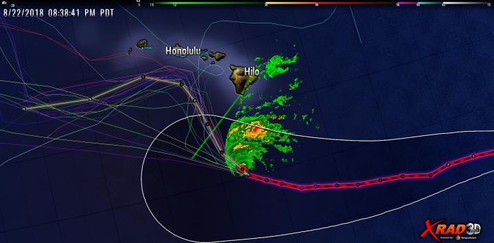
Latest radar


It looks like a near miss, but that could still have an effect.
Surf’s up!
Hoping for the best.
Having lived in Hawaii, everyone gets excited by Hurricanes coming (as usual) from the SE. There is a permanent High Pressure caused by descending cold air over the Big Island and, to a lesser extent, eastern Moloka’i caused by their respective two 13,000 foot (Hawai’i) and one 10,000 ft (Moloka’i) peaks.
I was present when Hurricane Ewa came from the SW (avoiding the Big Island) and clobbered Kaua’i and the North Shore of Oahu, leveling at least one hotel on Kaua’i.
Notice that the track actually shows Hurricane Lane skirting around the Big Island (although it shows it might possibly impact Moloka’i, which is that as not likely as a complete miss). That is probably caused by the rotation of the High Pressure.
My mother would call me 2 weeks before a Hurricane was to “arrive”. I would not have known about it because it wasn’t news until it got close enough to cause waves — surfer heaven.
Hawaiian building codes don’t require being able to withstand anything worse than a category 3 hurricane. link There are plenty of older buildings that don’t even come close to meeting that. If Hawaii gets smacked by a serious hurricane, there will be mass destruction.
I used to live on the North Shore of Oahu, about halfway between Waimea Bay and Sunset Beach. A long time ago.
Mann, Gore, and others were drooling at the prospects of Hawaiian devastation so that they could blame it on climate change.
Ha, I was at the gym today in the morning riding the bike and watching the TV. GMA was on and they had the transcript of the voices turned on. The meteorologist said something like this hurricane made history because it is the closest a CAT 5 ever got to Hawaii. I actually laughed out loud.
These people must look for any climate related event out of the ordinary so they can promote it on the ‘news’ as proof that capitalism and white Christian conservative US males in charge of the economy is a bad thing.
So has there been any warming in Hawaii in the past century?
Kramer, I live on Vancouver island off the coast British Columbia Can. and we are socked in with smoke from wild fires. A very rare occasion, caused by a high pressure system stacking and stalling the smoke over us. Its 24/7 reporting that climate change is causing this, with catch phrases like “unprecedented” and the “new norm”, expecting (or reporting) that we are all causing this because we are destroying the planet from our green house gas emissions from carbon….. of course they mean CO2 a molecule not CARBON an element, but they preach it as a dreaded pollution like toxic waste.
The mind boggles at the ignorance and hyperbola of the reporting, even with most of the government agencies with climate change, sustainability or environment stitched into a name of a ministry. Every act of nature is our fault and a tax and restructure of EVERYTHING is the cure. We must be like China the most green culture on the planet and we need to emulate it…. well except for HUGE amounts of coal, LNG and oil they use to sell us OUR resources energy back to us as a product. Oh yeah, their a developing country…. so we pay them and give them a pass on the insanity.
I’ve been considering leaving Canada, I cant afford to live here anymore and I have no more money to support MORE taxes for nothing…..
I have thought about leaving, too Lance. I’m in Ontario and we’ve had 15 yrs of “Liberal” gov new world order politics. Doug Ford (Conservative) swept the Libs so bad that they got only 6 seats and lost official party status (no gov funding). He immediately cut energy taxes and stopped the teaching of the extreme activist sex education that had been installed to make the “Diversity” klatch happy. He’s also is going head to head with the Feds on immigration, so I’m cautiously hopeful.
A plan was afoot to tuft Ontario with evermore windmills and the huge power output we already had was being sold at a huge loss to Michigan. The secret plan, when they reached their windmill goal, was to make heating with fossil fuels illegal! Imagine in Ontario! What have we let these people do to us? I dont even know the much jiggered national anthem any more.
I know British Columbia is even worse than Ontario. I’ve tried to tell friends and family the party you vote for is in name only. The constituency of these Neomarxbrothers is global, centralized in a totally corrupted Europe (the cruel joke is Europe seems unaware they have set in motion a demographic and world view shift that wont go for Elitist rule anyway – at least not their smug elitist rule. Nevermind the Paris Accord -idjits ).
Ford needs to require the schools to stop teaching global warming junk science.
sad….two groups of government employees….both using computer climate models
one group is trying really hard to get it right…
…and the other group is trying really hard to wreck us all
It looks like the eye will pass well to the south of the big island
(as of 11:30pm EDT):
https://eldoradoweather.com/current/satellite/western-hemispere-satellite-loop.html
I am on Maui in Kula on Haleakala at the 2500’ Level. At the moment it is very pleasant. Just started raining lightly, no wind. Stores are busy with people stocking up on food and drink. Many beaches were closed this morning. Looks like it will be a near miss from here. Wish us luck! I don’t believe Maui has experienced a hurricane in recorded history and not in the 40 years I have lived here, but plenty of close calls.
Anthony,
Are these categorizations as Cat 5 or Cat 4 based on surface wind measurements as from the 60’s and before, or aircraft measurements starting in the late 60’s, or Satellite measurements of wind speed at much higher altitude as recently? Claiming that there are more stronger hurricanes because satellites detect higher wind speeds is hideously misleading.
The categories are based on the estimated maximum sustained surface wind as assessed by the hurricane specialists at NOAA’s Central Pacific Hurricane Center. The specialists base their estimates on the various values they receive. In the case of Lane, these include satellite Dvorak estimates and both flight level and surface wind measurements from the reconnaissance aircraft. The surface values are obtained from a passive microwave instrument (SFMR) pointing downward. It is the specialists’ job to subjectively evaluate how much “weight” to place on each measurement then come up with a single value of the maximum sustained winds.
As to comparing historical and present day wind values, today we measure the internal workings of a hurricane far better than we did ten years ago, let alone 50 years ago. But there is an effort at NHC to evaluate past storm measurements and try to root out past errors. Unlike the effort to adjust past temperature records, this effort is more transparent and cautious to avoid allowing bias into the process.
Is there any sign the global warming meme is having any biased impact on the technical aspects of forecasts and tracks? ie. is there a tendancy for for forecast tracks to be pushed to scarier scenarios and the strength to be given the highest rating in the envelope? It seemed they changed the protocol for measuring Harvey to obtain a higher strength at landfall and apparently there was some fiddling with Saffir Simpson scale. Sandy, too was “enhanced”?
Google ” environment Canada weather” you get a side bar Wiki for ” Environment and Climate Change Canada” sooooo….weather is now climate change to a ministry. And they have a mealy mouth CHIEF Climatologist to tell you the weather now.
A climatologist to Interpretate the weather…when weather is not climate(as I’ve been told when it gets record cold ) ? If you said Chief meteorologist or some other atmospheric science, that is here and now of our knowledge I’d listen.
Environment and Climate Change Canada has a narrative, no matter what…….climate change is real and we’ve caused the planet to have bad weather day…hot cold drought flood, to little snow pack… to heavy snow pack, forest fires, earth quakes………………..Sorry what’s the weather tommorrow?
Oh yeah…… We are BURNING up!
Hopes and prayers go out to our WUWT family and islanders from we on another island! Stay safe.
Right now I’m on the big island in Puako. We should be sheltered from most surf effects by the bay, which faces North to Maui. I am most interested to see what Lane does to the Pakini Nui Wind Farm at South Point. This replaced the old Kamaoa wind farm which had fallen into disrepair and effectively ceased operating in 2006. Pakini Nui has 14 GE 1.5 MW turbines for a total nameplate capacity of 21 MW. So far I haven’t found a source for data on actual production. Sadly, there are other wind turbines on the big island, but Pakini Nui is the largest single facility there.
that second image looks just like the survey uncertainty matrices we work with in directional well placement in oil and gas well drilling. Interesting analogy.
I posted the link to the second image here https://www.smh.com.au/environment/weather/potentially-devastating-hurricane-lane-bears-down-on-hawaii-20180822-p4zz2i.html
And in typical alarmist Hannam style, it has not been posted. All reports on Aussie media state that it’s a massive, never before, hurricane that *WILL* smash in to Hawaii.
“Comments are now closed”….after only 3 alarmist comments were allowed !! LOL
My post, if allowed, would have been 4th. Comments now closed, that’s Hannam at the SMH. He closes articles down very quickly now as his biased articles can be torn to shreds in minutes.
On August 8, 2014 I posted a theory about interactions with small hurricanes and the high volcanoes of the Big Island. Thanks to Mr. Anthony Watts, that blog post will be around forever…heh
https://wattsupwiththat.com/2014/08/08/hurricane-iselle-disintegrates-before-landfall-in-hawaii/
Now a huge storm is heading in from the south the cooling effect is harder to detect, I’m betting it’s still a factor in the downgrade of the storm…
Go west young Lane, go west…