Guest Essay by Kip Hansen
 Paris, France is flooding again. The River Seine has risen over its banks and streets are covered with slowing moving yellowish water. The Louvre is building sandbag barriers to protect its statuary.
There is talk, as always, that the culprit is the dreaded modern boogeyman — Climate Change.
As our introductory image states, Paris is not just flooding, it is flooding again, and again, and again, and again.
“Why does the Seine, famous for its bridges, flood at all?
As one of France’s major commercial waterways, the river is closely monitored so it can accommodate a constant procession of barges and other commercial vessels. The river begins in Burgundy, in east-central France, and meanders 485 miles westward until it reaches its mouth, near the port city of Le Havre.
Upstream from Paris, four large dams control the flow of the Seine and three of its major tributaries: the Aube, the Marne and the Yonne. According to Charles Perrin, a hydrologist at the National Research Institute of Science and Technology for Environment and Agriculture, in late spring the dams start stocking large reserves of water that can be released in the drier summer months.
Dams and locks normally keep the water level consistent, particularly in the Paris region, where the Seine’s traffic is especially heavy, in part because of tourist and other recreational vessels. If the water level drops too far, the barges could scrape the riverbed and get damaged. If it gets too high, vessels cannot pass under the city’s lowest bridges.”
Last spring “The dams were already at 95 percent capacity when heavy rains started in late May, so their ability to take in the excess water was limited.” So, Paris flooded — again.
“Public authorities said they expected the Seine to crest on Sunday at up to six meters, or about 19.6 feet. In the floods of June 2016, which killed four people in France, it peaked at 20 feet.”
“Although some experts said it was hard to determine whether global warming was behind the current flood, others warned that a worrying pattern was emerging.
“Because of climate change, we can expect floods in the Seine basin to be at least as frequent as they are right now,” said Florence Habets, a senior researcher at the C.N.R.S., France’s national center for scientific research. “No matter what we say, the more we reduce our greenhouse gas emissions, the more we reduce our impact on droughts and floods.”
The French scientist tells us that “Because of climate change…” the flooding frequency will remain the same. Brillant!
What is the flooding frequency? Every recent flood is compared to the great flood of 1910, “in 1910, a January deluge turned Paris into Venice for a week — river levels rose nearly 30 feet above normal — causing roughly $1.5 billion worth of damage, in today’s terms. … Topographically, Paris is a basin, with hills in Montmartre and Montparnasse rising in the north and south of the city, respectively. When it comes to flooding, that means big trouble for anyone who lives in the city center, which in 1910 was not so different than it is today” [source]. “A very severe period of high water in January 1910 resulted in extensive flooding throughout the city. The Seine again rose to threatening levels in 1924, 1955, 1982, 1999–2000, June 2016, and January 2018.” [source]
The New York Times carried the story of the 1910 Paris flood — read the full original report on the front page of January 27, 1920.

This “worrying pattern” really began in the 17th Century with major Paris floods being recorded in 1649, 1651, 1658, 1690, 1711, 1732, 1740, 1779, 1795, 1802, 1830, 1836, 1879-80, 1882-83, 1886…..you get the idea here.
What’s the deal here? Again, as with Bangladesh: GEOGRAPHY.

There we have it. Four rivers flow into one another and converge just before Paris: The Seine itself, the Aube, the Yonne, and the Marne.
Google Earth reveals that the Seine is no longer a river but a channeled and closely controlled canal, complete with flood control devices and locks for the river traffic.

We see once more that the efforts to control great rivers and put them solely to our own purposes leads to unforeseen, or at least, unacknowledged, problems. The upriver dams, used to store water against the dryer summers, to maintain river levels appropriate for shipping, are allowed to fill in the Spring, find themselves nearly full — and if late summer rains come, there is nowhere to store the resultant excessive river flow — floods start upstream and spread down the river to Paris. We see this same pattern with the great rivers of the American Midwest — the Mississippi and the Missouri.
Of course, the Europeans have known all about this situation for years and years, and publish reports and recommendations such as OECD Reviews of Risk Management “Policies Seine Basin, Île-de-France: Resilience to Major Floods”.
Still, Paris floods and the blame gets shifted to anything but the real cause — inadequate action to remedy the known problems of Seine River managenment.
Remember our expert Climate Science opinion: “Because of climate change, we can expect floods in the Seine basin to be at least as frequent as they are right now,”
# # # # #
Author’s Comment Policy:
Love to read and respond to your on-topic comments.
Paris floods — that’s weather — so it must be Climate Change.
If you want me to respond specifically to a question or comment, address it to “Kip…” so I am sure to see it.
# # # # #
What a surprise! All the urbanized, impervious surfaces there, and channeling of all the rivers, and it rains hard, and then………..
“If the water level drops too far, the barges could scrape the riverbed and get damaged. ”
So why don’t they just dig it deeper? Twice as deep would double the maximum flow capacity to handle the heavy rain periods and make it much easier to maintain a constant level.
Mike ==> There is a limit to the dredging depth — they eventually hit bedrock. The whole river system and the locks and all has been developed over centuries…..factually, the entire river has been turned into a 500 foot wide canal system. Canal systems have to have depth control — too shallow and the boats hit bottom — too high and the boats can’t pass under the bridges.
I’m sure hitting bedrock was a snag 300 years ago. Today … not so much. No one would have even dreamt of doing this not that long ago – https://www.popsci.com/technology/article/2010-10/after-14-years-worlds-longest-tunnel-breaks-through-swiss-alps
Doubling the depth of the channel more than doubles flow capacity. That increase sounds like it would be more than enough to cure their problems.
Mike ==> You forget that the flip-side is that they have trouble keeping enough water in the system. — this is a canal system with locks and flood control mechanisms — see the photo in the essay. The problem is much miuch more complicated than simple “volume of flow”. Read the OECD document (linked in the essay and somewhere here in comments.
Just need to redirect 1/2 of that flow around the flood zone during the times of potential flooding
Kip: ” … forget that the flip-side keeping enough water in the system. ….. this is a canal system with locks and flood control mechanisms ”
The evaporation loss rate would stay the same. Those same flood control gates regulate the level.
Kip: “The problem is much miuch more complicated than simple “volume of flow””
No it isn’t. Flooding is from an inadequate capacity to move a given rate of flow with a given amount of head. This ain’t rocket science, you can make the river wider … or you can make it deeper. If you do neither it will get wider on its own.
Bryan A: “Just need to redirect 1/2 of that flow around the flood zone during the times of potential flooding”
Which accomplishes exactly the same thing as digging a deeper channel – increased flow capacity.
Plus if they go too deep it’s like millions of degrees down there, dude.
Except that lowering the base of the river effectively lowers the Low Water Point during the summer months.
The best way is to divert a portion of the flow during excessively high volume times
Bryan A :”Except that lowering the base of the river effectively lowers the Low Water Point during the summer months,”
That’s what water level control spillways are for! Those establish the height of the water in the channel – not channel depth.
But then maintaining the greater water volume required to retain normal river height respective to locks effectively negates the extra depth gained by dredging and would still limit the amount of emergency flow room as the elevation space between the surface of the river and the city streets is still unchanged. You just have more water flowing through the city. Dredging drainage ways for increased potential volume does make sense but on navigable river systems used for daily transportation dredging has a negligible effect on potential flooding as the surface level is unchanged
Brian: “But… would still limit the amount of emergency flow room …”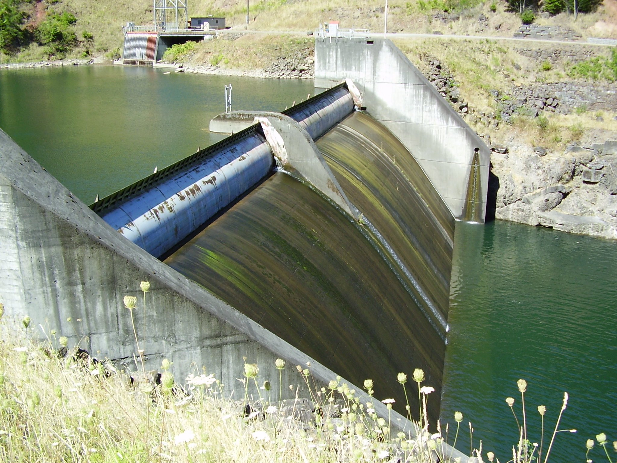
No. You seem to be purposely ignoring the use of active floodgates or wide passive spillways (if you can afford the real estate in the places you need to put them), or a combination of both:
Such things are ‘ancient’ technology that still work and are used all over the world. They provide the required level control in normal conditions but can permit a large increase of flow capacity when needed. The river or canal ALSO has to have the capacity for that higher flow and that can be accomplished by it being wider or … deeper which is the only point I suggested.
https://en.wikipedia.org/wiki/Morganza_Spillway
Mike,
Then I have to ask…exactly how does dredging the base of the river deeper stop flooding?
Bryan A: “Then I have to ask…exactly how does dredging the base of the river deeper stop flooding?”
By increasing the flow capacity of the river to be there when it is needed!
There is no difference between making a river wider or deeper, either way increases cross sectional area.
But the flow capacity isn’t there if the river height is still maintained for shipping purposes. The difference would be instead of shipping on a river that is 20′ deep with a surface 18′ below street level you would be shipping down a river that is 30′ deep and 18′ below street level. Regardless, the distance between the surface of the river and the street level is unchanged. The extra depth is still full of water and gives no additional room between the surface and the street. Th Gove the extra room,.you would need to dredge AND lower/extend the other shipping infrastructure (locks, platforms, stairways, etc.) down to the new river surface level. Then you would need to dredge more than the area where flooding occurs, you would need to feather the dredged depth back into the normal depth much farther downstream.
In essence, dredging the river deeper through the flood zone will only give you a deeper river but won’t affect the river level.
Bryan A –
It’s unclear what you mean by that. The nominal level of the water at normal flow would remain unchanged. The deeper depth will provide more cross sectional area and therefore a higher flow capacity.
That’s correct and there is no need for “additional room” because with the added capacity the water isn’t going to rise anywhere near as much as it does now in flood stage.
Huh? Now you contradict what you stated above implying that the surface will be lower. No … it will NOT be lower and does not ever have to be lower! You were right the first time so there is no need to change existing locks, docks and stairways.
Nowhere did I make the silly suggestion of dredging only the area where flooding occurs. Capacity has to be increased to be at or above some minimum “X” from the flooding point all the way downstream to the sea.
Basically repeating your wrongheaded assumption that I am stupid and suggested dredging only in the flood zone or that I suggested changing the level of the water. Neither is true and repeating it will not change that fact.
Would it be a massive project? YEP! .. and I never suggested it would not. It’s possible that every single one of their level/flood control points (gates and spillways) would need to be rebuilt/augmented/expanded to accommodate the increased capacity.
If they had started 150 years ago they would have been done by now which leads me to suspect that either Parisians really don’t care all that much about the occasional flooding or it has been doing it for so long (flooding in 1658 matched 1910) that they think it is something they are forced to accept.
150 years ago the Mississippi presented massively larger flooding problems including issues like yellow fever, (1878). Lucky for us there had not been much of a population established along its banks for centuries before then thus affording a greater variety of options for mitigation such as the TVA for example.
Sorry Mike but I never once called you a name nor suggested/intoned you were anything but intelligent.
I am simply stating that increasing the river depth will do nothing but increase the river depth. It supplies no additionall capacity for emergency flow because the additional depth (currently filled by earth) will be refilled with water before any emergency situation happens. Filled is filled either way and supplies no emergency buffer.
There simply won’t be any added capacity if that capacity is already filled with water to maintain the existing water level for commerce.
Bryan A
Wrong. You simply do not understand. As I stated earlier, deeper or wider makes little difference. Either increases the flow capacity by increasing the cross sectional area.
A bigger channel can move more water … PERIOD!!!! How can anyone disagree with that?
You are correct that a bigger channel can move more water. But if the river surface height has to remain unchanged, the only way to increase the channel dimentions is to go wider rather than deeper and through central Paris wider isn’t an option.
Right now, through central Paris, the Seine is 100 meters wide and around 8 meters deep with the surface of the water around 2 meters below the pedestrian walkways along the river bank. That 100 meter width is constrained by streets on both sides so going wider isn’t an option.
If your river height must be maintained at 2 meters below pedestrian riverbank sidewalk level (7 meters below street level) for river traffic to flow and ease of access for pedestrians then that traffic doesn’t care if that river is 5 meters deep or 10 meters deep. (additional water flow wouldn’t care either)
To maintain river traffic access to the river bank pedestrian sidewalks, the river would need to be maintained at 10-11 meters deep instead of 6 or the boats would be 7 meters below the walkways.
If you fill this extra space with water to maintain the original river level, you still only have 2 meters to the walkway and 7 meters to street level.
You have a 370 km distance to the sea (as the river flows). If you have a river that is derdged 5 meters deeper, you would likely need to either gradually feather out the western portion or dredge 370 kilometers to the ocean. Either way you now have a river that is 13 meters deep instead of 8 and water that is 11 meters deep instead of 6 still with 7 meters of space between the river surface and street level.
Think of it this way
Take 2 water bottles. Cut one off at 3″ from the bottom and the other at 4″.
The cut represente the street level and the bottom is the river bed.
Mark the 3″ deep one at 1″ from the top as this is the level that must be maintained for shipping.
Now mark the 4″ deep one at 1″ from the top. (this is the level that still must be maintained for shipping)
…The extra inch deep is the new dredged river depth
Now fill the 3″ deep one to the mark, this is the regular water height. Now add an additional 1.2 inches of water into the 3″ deep container (doesn’t hold it)
So now for the dredged river
Again fill the bottle to the mark (there can’t be any less water for shipping to function) and then add the 1.2″ of water into the 4″ deep bottle
A Bottle of constrained sides or River with constrained banks Still won’t handle the emergency flow even though both have a greater volume IF that volume is full prior to the emergence flow situation.
Bryon “the only way to increase the channel dimentions is to go wider rather than deeper”
No, you are wrong. Given identical head, a bigger channel has greater flow capacity than a smaller one regardless of whether it is wider or deeper.
I defy you to explain how that cannot be true! `(Don’t bigger pipes have a higher flow rate at a given head?)
In your earlier explanation you stated there was no difference if there was water at the bottom of the deepened channel or dirt. Yes there IS a difference because water FLOWS … dirt does not.
Bryon “…:even though both have a greater volume IF that volume is full prior to the emergence flow situation.”
Static volume is irrelevant here, only cross sectional area matters. (CSA)
Flow rate = CSA * average velocity.
You cannot get around that simple fact.
I can’t believe all the time I’ve wasted on trying to educate you.“Go to school and pay for a course in hydraulics. Here’s a calculator if you still don’t believe me – http://www.engineering.com/calculators/open_channel_flow.htm
If you don’t like the results that that gives you when you increase channel depth – pester them not me because I give up!
(it shows a more than doubling of flow from doubling the depth because there is a smaller wetted perimeter to CSA ratio the larger the channel gets. Use N=.015)
Mike,
Your pipe analogy is slightly flawed. Yes the larger pipe will carry more but the pipe is larger in radius (every direction.) Not just deeper.
The key is in your statement
This implies that the capacity will not be used when not needed but the deeper river will still be filled to the point of 7 meters below street level to maintain shipping level. This effectively uses the additional capacity before it is needed and renders it unavailable as additional capacity. It isn’t additional unused capacity if it is being used. Again refer to my bottle analogy.
Bryan – I already told you that static capacity has nothing to do with the improvement of flow capacity. You refuse to believe me and ignore my examples and explanations. You are wrong and I’m done trying to explain it to you, go bother someone else. Keep it up and I’m just going to keep giving you this same answer.
Have a nice day
Bryan A and The Original Mike M,
I think you guys are both right, and don’t realize it. TOMM says that making the river deeper will increase its flow capacity, which Bryan A doesn’t disagree with. But Bryan A maintains that if you make the river bottom deeper, and *still want to maintain the current surface height*, then you’ll need more water in the river (more flow) in non-flood conditions, which is true, and then where’s that water going to come from? And given that the increased flow (compared to the present situation) is going to be there all the time in order to maintain the surface height, how does the river’s capacity to deal with floods get any better?
Steve Keppel-Jones –
“I think you guys are both right, and don’t realize it. TOMM says that making the river deeper will increase its flow capacity, {A}which Bryan A doesn’t disagree with. But Bryan A maintains that if you make the river bottom deeper, and *still want to maintain the current surface height*, then {B} you’ll need more water in the river (more flow) in non-flood conditions, which is true, and then where’s that water going to come from? And given that the {C} increased flow (compared to the present situation) is going to be there all the time in order to maintain the surface height, {D} how does the river’s capacity to deal with floods get any better?”
{A} False. I claim that making it wider or deeper will accomplish the same thing. Bryan has repeatedly claimed that that is not true.
{B} False. More water in the river is not the same as “more flow”. It will simply be slower flow than it is now.
{C} False. Flow rate at any time is managed by river level control points as it always is – making it wider or deeper only increases the FLOW CAPACITY (which is NOT the same thing as volume capacity).
{D} The same way a bigger drain pipe can empty your bath tub – a higher flow rate.
Corrections
{B} False. More water in the river is not the same as “more flow”. It will simply be slower velocity than it is now for a given flow rate.
{D} The same way a bigger drain pipe can empty your bath tub faster – a higher flow rate.
But if that larger bathtub drain pipe were constantly 3/4 full instead of completely empty, the bathtub would still drain just as slow as the smaller empty pipe. The river is like the pipe that is constantly 3/4 full.
Now for the dredging.
While feasible, the dredging operation, if worked from the confluence of the Marne, to the end at La Harve, the operation would require removing (presuming a 5 meter deep dredge is what you alluded to) 5 meters deep by 100 meters wide by 370 kilometers long.
This is roughly (5 meters X 100 meters X 370Km) 185,000,000 M³ of soil that needs to be excavated and barged and dumped someplace that it won’t effect fisheries or recreation areas.
It also equates to a surface area of 71.42 mi² 1 meter deep
Bryan A – “But if that larger bathtub drain pipe were constantly 3/4 full instead of completely empty, the bathtub would still drain just as slow as the smaller empty pipe. ”
It what universe is an empty pipe draining any water at all?
For the bathtub drain to function it has to be clear otherwise it is clogged and water will not flow…that is what I mean by empty. When the bathtub is full of water, much like he upstream dams, the drain pipe IS empty, But the river is 3/4 full. When you remove the drain plug, the tub empties into what was an empty pipe. In this case, a larger pipe will still only drain as fast as the tub drain size allows. But when the water gates (drain plugs) are opened on the dams to alleviate potential problems from rain overflow, the river isn’t empty it is 3/4 full. If the drain pipe on the bathtub were partially clogged (constantly 3/4 full like the river) the tub would only drain as fast as the smaller pipe. The only space for additional emergency flow is the space between the top of water and the street level (the unclogged portion of the pipe)
It is the air space above the river that is the emergency flow space
Large companies saying they will relocate after Brexit can already guess who is going to pay for any long term fixes for Paris’ problem… Better to remain in a City that is ahead of the curve on flood prevention/mitigation? Nobody droned on about global warming when the Thames Barrier was on the drawing board.
michael ==> They have plans….and plans….and plans…. what they don’t have is action — construction … or the necessary political will. There had been a “pause” in really serious flooding until 2016 (Paul Homewood wrote about last years flooding here.) With flooding out of the public eye, action was delayed and put off.
Kip I remember Paul’s post, it is like deja vu! The same comments “unprecedented” “its worse than we thought” when in reality it is neither of those things, the river level markings on the statues prove that. As others have said the Seine is not the same river it was decades ago so comparing like with like is impossible.
andrewmharding ==> Well, the sad news is that the Seine IS the same river it was decades ago, and centuries ago — so it still floods PARIS!
Tough the problems are well known and well studied, and plans have been formulated, not enough has actually been done to safeguard the city from flooding.
Which is most unfortunate, during the lull times is the time to act while during emergency situations is the time to react. California should have been preparing for the potential Oroville situation during the drought instead of needing to react to it after the El Nino rains.
Indeed, Bryan A. There you have it.
Global warming is being used as both the scapegoat for past inactions while simultaneously being used as justification for [taxation for] future actions. Future actions which are not even being started, despite the efforts being spent on the explanations of why we should “do something”.
The dissonance is incredible. As Yoda said, “Do, or do not. There is no try.”
Construck a spill way around the city to take the overflow controlled of course!
http://www.historyinorbit.com/wp-content/uploads/2017/11/14.jpg
The streets of Paris looked quite different during the Great Flood of 1910. Boats are seen here rowing down what would have been a busy street
That has to be photoshopped; in 1910, CO2 levels weren’t nearly high enough to cause that kind of flooding.
A lot like other spoofed stories they got away with back then like low arctic ice in 1922. (/sarc) https://wattsupwiththat.com/2008/03/16/you-ask-i-provide-november-2nd-1922-arctic-ocean-getting-warm-seals-vanish-and-icebergs-melt/
Don’t you realise that logic and facts are constructs of the Western, imperialist, white, male patriarchy? Narratives and, muh, feelings are a way valid basis for organising society. (sarc)
Sorry about error – “way more valid”
If climate change gets blamed for droughts on the one hand and flooding on the other, shouldn’t it get recognized and praised for all the good stuff in between?
Climate change was recently blamed for reducing the extreme rainfall events somewhere in the southwestern US and affecting streamflows. Everything climate change does is bad bad bad!!!
Who can ever forget Steve McIntyre coining MBH98’s “rain in Maine falls mainly in the Seine?”
https://climateaudit.org/2007/11/21/mann-et-al-2007-precipitation-teleconnections/
Wasn’t Paris built on what was originally a swamp? An area prone to flooding?
Bill ==> According to TVW (The Venerable Wiki),it was first a river crossing.….and may or may not derive its name from some word that meant swamp or march.
Kip, when I was in Paris two years ago I had a good long look at a few historical maps of that city. Sure enough, a good deal of the terrain was originally swamp with, as you say, a river crossing. Mostly the modern post-Haussmann drainage systems cope with the extra influx of flood water, but every so often they prove inadequate. Like, as several other posters have pointed out, the great flood of 1910.
Seems their only option is to deeply dredge the 123 mile path to the sea and accelerate the 115 ft drop.
Is that insane or in some sort of theory with no other considerations buy water flowing downhill is it possible?
Steve ==> We have a few civil engineers who read and comment here….maybe they will give opinions.
The major problem is that the Seine is not a free flowing river — it is a major transportation canal, use Google Earth to view is — follow it upstream and downstream and you’ll see what I mean.
The problem is what to do with all that water when the heavy rains come. Paris is in the center of the “Paris Basin”…the name gives a hint.
You point out the salient point of Geography….Paris is only 115 feet above mean sea level. The distance by river to the sea is 240 miles. That gives an average drop of less than six inches per linear mile …. almost no drop at all…..
By contrast, Albany, NY (the capital of NY State) has an elevation of 312 feet and a distance to the sea of 150 miles — a drop of 2 feet per mile.
Kip, thanks for replying to my pondering. That much greater distance by the curvy river certainly makes a big difference. Although my checking shows the waterway to be 344KM or 213 miles.
But humor me more. Suppose a straight canal were dug? Or rather a 213 mile long, straight spillway dropping 115 ft?
If money were no object and all other impediments waved would such a spillway work?
Steve ==> I am no hydrologist — but — sure — creating a giant new riverbed capable of handling the flows of the flooding rivers would solve the problem……but that’s a 100+ mile channel several times the size of the Seine running through cities and farmland and who knows what all….See GoogleyEarth….
I think the Eu plan calls for capturing much of the water before it gets to Paris, filling upriver catchments and controlled release.
Great article. One thing though: highest point in Albany is over 300 feet. The lowest is,effectively, sea level. The river there is tidal. Technically, an estuary.
Rick ==> Ah — ya caught me. The river is tidal all the way to Troy, just north Albany. There is, however, a substantial enough drop that the river flow is quite strong in the southerly direction when the tide is out at NY Harbor.
That said, the tidal flow north is string as well when on the flood.
When I sail my little Force 5 sailboat on the Hudson, I have to check the tides so I don;t get caught trying to get home against the tide in low wind conditions.
That’s correct, a bigger channel can move more water whether it is widened or deepened. With water surface levels kept the same the locks can remain as they are so the only other thing needed is to increase the flow capacity at the flood/water level control points to handle the higher flow rate when needed.
Maybe they should talk to the folks that did the diversion for Winnipeg. I mean this is an engineering problem that is easily solved. WTF is the problem France? Too distracted with tabloid junk just like everywhere I guess.
TRM ==> If it were truly “easily solved” it would have been handled back in 1910.
Easily solved with extreme care. Digging a channel to draw off water could easily get out of hand if uncontrolled amounts of water start swilling down the new channel gouging out a new path.
It seems that the reason for the collapse of the hydraulic civilisation at Angkor Wat and its abandonment was the digging of a new channel which was disasterously lower than the rest of the canal system, leading to a catastrophic uncontrolled flow out of the higher drainage system. If true a whole sophisticated city collapsed as a result.
politicians love climate change. it shifts the blame from politicians to the populace.
They are missing the boat on this one — they could claim that this flood would not have happened if the US hadn’t left the Paris Climate Accord.
Someone will claim it will happen more often because the US left Paris…
Rhoda ==> 😉
Wait, so flooding is caused by summer rain when dams are already full?? Has anyone told Flannery?
Andrew ==> ONE type of Paris flooding is caused by late spring rains, after the dams have been filled in expectation of a dry summer. There are other causes for other times of the year. See this online book for details The River Seine by Leveson Francis Vernon-Harcourt..
Good post Kip. It is amazing how people knowingly built in flood prone regions, have experienced severe flooding in past 200 years yet still mindlessly blame CO2 climate change for natural variability, like in Houston, New Orleans, etc.
Jim ==> Yes, very much like New Orleans especially, with its relation to a tightly controlled major river.
My first big job as a fresh new engineer was a big one indeed – doing hydrological investigation along the right-of-way of the to-be constructed Greater Winnipeg Floodway. We, too, and the folks in Fargo, ND and points south on the Red River of the North had frequent major floods. The towns and cities along the Red were also on the lake bottom of the Pleistocene Lake Agassiz and the floods were essentially a refill of the ancient lake. Being out in the plains as well when the floods came the area inundated was enormous. Here is a photo of an inundated railway bridge in the big 1950 flood – I filled sandbags in my community of St James, Manitoba as a boy scout.
http://www.rmofmorris.ca/wp-content/uploads/2014/01/313.jpg
From Wiki: “The construction was a major undertaking with 76.5 million cubic metres (2.75 billion cubic feet) of earth excavated—more than what was moved for the Suez CanalAt the time, the project was the second largest earth-moving project in the world – next only to the construction of the Panama Canal.[7] The total cost at the time was $63 million (CAD), equivalent to approximately $505 million today.”
Duff’s Ditch!
Gary ==> Maybe you could do a piece on how Winnipeg was saved by engineers. ? There are a lot of flooding stories covered here at WUWT.
Excavation of the Winnipeg floodway unearthed gypsum crystal clusters that had grown in the clay, some several kg in weight. There are gypsum deposits north of Winnipeg and probably gypsum powder ground from the deposits by Pleistocene glaciation wound up being dissolved in Lake Agassiz, later to grow in the lake bottom muds. Gypsum is moderately soluble ~2g/L.
https://www.minfind.com/mineral-559717.html
That takes me back to my youth, Gary. I recall digging for near perfect gypsum crystals, often several inches long, in clay mounds left from local building projects in Central England. I could understand the excitement of a miner or gold prospector.
$505M seems well worth it…especially since it has allegedly saved over $10B in flood damage.
Instead, France will probably subsidize $500M of solar and wind, claiming it will reduce future flooding.
“Instead, France will probably subsidize $500M of solar and wind, claiming it will reduce future flooding.”
People of Galveston TX are lucky the storm in 1900 didn’t happen in 2000 because instead of spending to build sea walls, jack up important buildings and elevate the terrain they would gotten the “benefit” of the most expensive climate models our tax money can buy.
Bravo Gary – just saw your comment now.
from wiki:
Since its completion in 1968, the Floodway has prevented over $40 billion (CAD) in cumulative flood damage.”[3] It was designated a National Historic Site of Canada in 2000, as the floodway is an outstanding engineering achievement both in terms of function and impact.”
“Warming will cause a predictable increase late summer rain which we will not be able to predict, causing us to leave insufficient room for it in our reservoirs.” In other words, Gorebal warming causes brain damage. Finally a warmist proposition I can agree with.
There doesn’t seem to have been much thought given as to why flood plains are called … flood plains.
Hey! sanity isn’t allowed here, now behave yourself.
From the French vigicrue site. Google it . It is interactive. This the central paris data with past flood levels
Image failed to post. Probably because I haven’t a clue how to do it
Go to the website and click on the image. If the image opens in another window, and the URL address ends in .JPG, copy the URL (http) address and paste it into your post. If clicking on the image does nothing, right click on it and select PROPERTIES, part way down you will see the image tag with the .JPG extension. Try copying and pasting this into your post. At the top of this website in the gray bar is the test page. Try posting the image there and see if it posts first.
Stephen ==> For the image to post, the url must end with .jpg (maybe .png works as well). Nothing allowed after the .jpg (file type). The image url must be on its own line as well, I believe.
Hendric Svensmark isn’t surprised.
Let them eat soggy cake.
Yep the French have figured out how to control the weather . Must be all those X NASA climate fabricators they are recruiting .
Most places would be happy with some extra rain .
Now hold it, weren’t the predictions extreme drought from climate change? Or, I guess maybe I did hear that it could also cause flooding, depending on your location and the regional precipitation upstream. Man… Climate Change just hits us daily.
(sarc factor 7)
You mean like the worst drought in a century currently hitting Cape Town, expected to run out of water in April.
Cape Town’s population has grown from 2.4 million to 4.3 million since 1995. Water supply storage has increased merely a small fraction.
Following the last increase in storage in 2009, the Department of Water Affairs and Forestry warned that demand would exceed supply by 2013 without any water conservation management and demand measures – and that those would only delay this until 2019. The catch was that this was based on “normal” rainfall levels. Drought conditions would muck this up…and that’s exactly what happened.
You can even go back to 1990 when water supplies were eerily projected to “dry up in 17 years time” by the Water Research Commission.
Level 4 water restrictions were not imposed until the end of May in 2017. Level 5 wasn’t imposed until September. Cape Town passed last May on a proposal that would have supplied 100 million liters of desal before the end of 2017 and then a full 450 million liters (2/3rds of Cape Town’s needs) by the end of 2018.
The drought has simply exposed the poor planning, lack of preparedness, and utter ignorance of government.
True. Isnt it convenient to blame poor planning on climate change?
Paris Is Flooded With Rats As the Seine River Continues to Rise
http://www.travelandleisure.com/travel-news/paris-flood-louvre-closure?utm_campaign=&utm_content=5a6b7e3a04d3014f27923a3a&utm_medium=&utm_source=&xid=TrueAnthem_Twitter