Thanks to Bob Tisdale, we’ve covered the evolution, peak, and demise of the sea surface temperature phenomenon labeled as “The Blob” in the North Pacific for awhile now. According to Wikipedia:
The Blob is the name given to a large mass of relatively warm water in the Pacific Ocean off the coast of North America. It was first detected in late 2013 and continued to spread throughout 2014 and 2015.[1][2]
Sea surface temperature indicates the blob persists into 2016.[3] This warm water mass is unusual in ocean conditions and is considered to have a role in the formation of the unusual weather conditions felt in the Pacific Coast.
The Blob was first detected in the autumn of 2013 and the early months of 2014 by Nicholas Bond of the Joint Institute for the Study of the Atmosphere and Ocean of the University of Washington, and his colleagues, when a large circular body of sea-water did not cool as expected and remained much warmer than the average normal temperatures for that location and season.[5]
Bond, who is the State Climatologist for Washington, coined the term “The Blob”, with the term first appearing in an article in the monthly newsletter of the Office of the Washington State Climatologist for June 2014.[6]
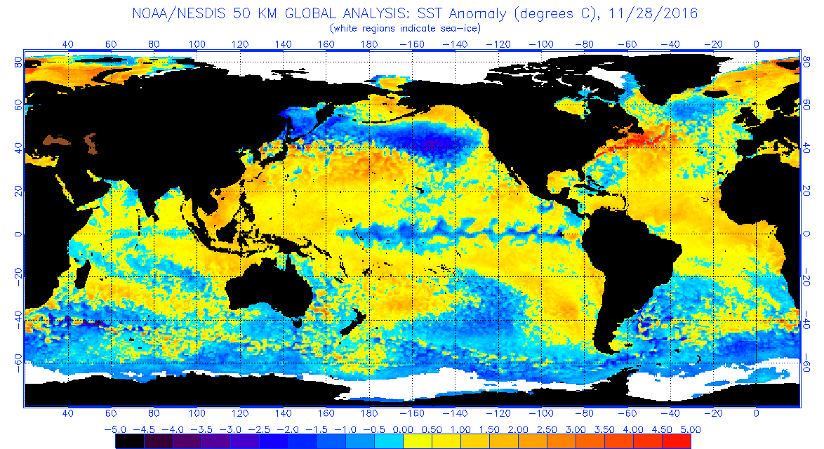
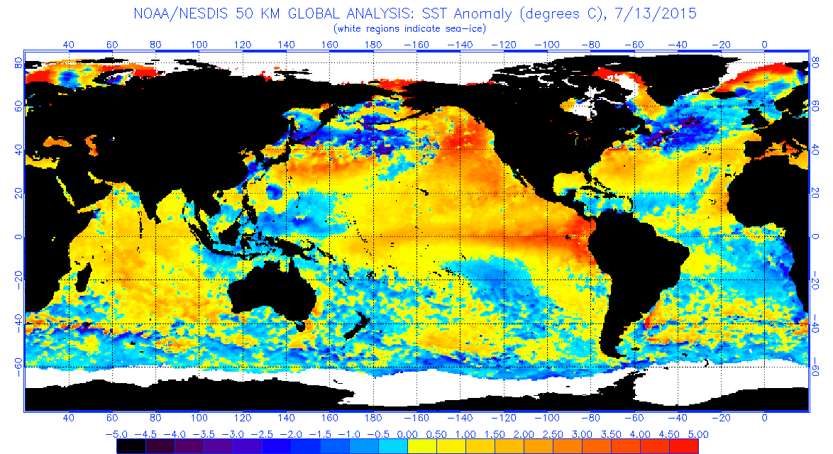
Well, “The Blob” as warmists knew it, is no more. Compare these two panels of sea-surface temperature:

Top panel: November 28th, 2016 Source here
Bottom Panel July 13th, 2015 Source here
Also note the strong La Niña pattern in blue across the Pacific equatorial region in the top panel, along with the many other areas of below normal SST. Since SST tends to drive global air temperatures, it looks like 2017 might be a colder year globally if this keeps up.
Did the heat somehow move to the arctic? link Holy Moses it’s warm above 80 deg. N. lat. If it doesn’t get cold quickly, we’re going to set records for minimum ice next summer.
Could this be an example of Judith Curry’s stadium waves? Is it only a coincidence that the arctic got warm when the blob disappeared?
The poles are where tropical air and water go to die.
When the wind dies and the sky clears and with 24 hrs of night , any air over the ice will radiate its heat quickly into space. The air over water takes a bit longer, since it has to absorb the heat from the water under it until it freezes, but again it doesn’t take that long.
Plus even though the air is anomalously warm, its actual temperature is still pretty cold.
Go out into the desert at night in the winter and see how fast the temperature drops on a still winter night. Check back in January and see where we stand.
+1
commieBob
Yes it did. There was a higher than normal movement of atmosphere into the Arctic area this year, near identical to 2012, when the sea ice minimum was set (in recorded history). It started moving there about mid year, about the same time that the Pacific cyclones started occuring. Less atmospheric volume moved to the southern hemisphere than the historical average in 2016.
Lets see what the cold blob actually does, as I think it is a bit early to tell. It has been as cold as a witch’s whatever in Oz for their spring, so I do not know what this sort of thing means over the whole Pacific Ocean.
yup Dec 1st and I am hugging a wheatbag n debating turning heater on…powercost means one has to consider that
and more rises in price coming due to stuffup SA and Vic coalplant shutting soon;-(
Are the colors (anomalies) based on yearly average, average for that day, or what?
One thing we know about “Weather” is that is variable. It was -3 C and snowed in Saudi yesterday. I was in the UAE a few years ago for an endurance horse race in the fall. The expected “normal” temperature was 20 to 25C but on race day it ended up being 45C plus. Seems like variable WEATHER is pretty normal to me but then I have only been about for one 60+ year cycle so who knows?
http://strangesounds.org/2016/11/anomalous-snow-saudi-arabia-desert-videos-pictures.html
Perhaps the gods weren’t happy with OPEC agreeing to limit oil production.
For Windsong and Cold Wind – Joe Bastardi predicted higher than normal snow in the North West this year and so far he has been right. I went skiing in very nice Powder at Banff, Alberta on November 18. Some resorts have opened early. Good snow in most of the west:
http://blog.liftopia.com/ski-resorts-in-the-west-deep-in-snow/?utm_source=Liftopia.com+Email+Subscriptions&utm_campaign=f57dc64cac-The_Goods_11_30_16&utm_medium=email&utm_term=0_9720800db0-f57dc64cac-333097341
http://www.revelstokemountainresort.com/multimedia/video-gallery/separate-reality-preseason-2016?utm_source=RMR+Subscribers&utm_campaign=fce2734ae0-collective_strike_7_2016_11_28&utm_medium=email&utm_term=0_4ef53f1987-fce2734ae0-299400737&goal=0_4ef53f1987-fce2734ae0-299400737
Only western Canada has above normal snow. For the western US, pretty much every basin has below normal snowpack
http://www.wrcc.dri.edu/snotelanom/basinswe.html
Saskatchewan and Manitoba also very little snow and considerably above normal temps this fall after a fairly cool, wet year generally.
You may have seen Australian wild horses race then Wayne. About a decade ago, the Sheik had his Australian vet catch a dozen wild horses from Lake Gregory on the edge of the Tanami and Great Sandy Deserts, where temperatures can vary from below freezing in winter to near 50C in the shade in summer.
Very tough and hardy part Arabian brumbies. https://pindanpost.com/2011/08/01/lake-gregory-horses/
one thing i noticed with the current enso picture the “waves” of cold temps, the cold northerly “waves”, they line up relatively close with the location of the tao monitoring buoys, can someone do a comparison, because iit looks REALLY close (via mk1 eyeball)…could the model not not be projecting correctly across the ocean, if buoy to buoy is the “same” temp. shouldn’t the temp between them be also interpolated about the same as well? (i know ocean dynamics and currents alter some temps but seeing the peak to peak distances almost all be equidistant from each other implies to me a bias somewhere- i don’t think nature would be that symetrical.
Sea Surface Temperature Anomalies, Ice and Snow Cover.
The Blob has gone under North America and reappeared in the north Atlantic. Teleconnection, that’s what it is.
No, it went over North America. That is why we had warm air temperatures during November.
Now that the blob has plopped down in the North Atlantic, cold air temperatures were return to North America in December.
(If you don’t believe me, I have a model that proves it. I just can’t show you my data. //Alarmist hat off//.)
That warm area in the Atlantic from the NE states up past Nfld has bugged me for a long time. Has anyone measured the temp of the rivers running into the Atlantic from the Wash-Boston corridor? Or the discharge directly from the cities? Then add the major flow from the St. Lawrence system (Great Lakes region) and all those major cities. I am aware that it would take a lot of warm water outflow to affect the ocean temps, but we are talking about only a degree or two. What do you think?
Gulfstream spilloff?
Same here. Been watching this for a couple of years now. Can’t be from the Gulf as the Gulfs temps barely matched this blob’s temps even in summer months. Could the cold mass off of Europe be blocking it? Did Iceland’s volcanic eruptions change ocean currents there?
The Blob is yet another sea temperature anomaly that seems to be geographically tied to an area with a seismically active sea floor – in this case the Cascadia subduction zone and the Juan de Fuca Plate.
I’m sorry – “strong” La Nina??? I don’t think -0.5C anomaly quite qualifies as …strong. I believe the correct adjective you are looking for is: weak
Lord Monckton:
All this talk of La Nina, the pause, El nino from both sides of the debate has really been for statistical reasons, perfectly without foundation.
A much larger yearly sample than decades is required to assess climate change.
The span of the Holocene is perfectly acceptable for statistical purposes.
Guys like Griff have a statistically insignificant 2 or 3 year wind of observations.
By focusing on the last decade or two plays into the hands of the global warmists.
Ask if they disagree with the 10,000 years or so data that shows we are falling into another ice age.
I, of course stand to be corrected.
Hans
oops make that window not wind
Climate Blobbers will be disappointed to hear this.
The warm Blob was caused by a persistent high pressure system over the area.
One has to take the 61 year ocean PDO/AMO cycle evolution into account…. which means: How was the blob 61 years ago? The prevous completed 61.year cycle must show us how the red blob turned into a blue blob and what followed after this…..
…This is, what “cycle” means and the blob re-appears in its proper cycle time position
PDO/AMO cycles do not develop without some force, which is driving these cycle. This cycle of 61 years fits perfectly with the 60 years cycle of cosmic forces existing in our solar system originating from the harmonic cycles of Jupiter and Saturn
http://www.scienpress.com/journal_focus.asp?main_id=59&Sub_id=IV&Issue=1564
Joe Bastardi predicted this three years ago. Its a rerun of the early 50’s. First a “blob” and widespread high Pacific SSTs. This evolved slowly to cold temperatures across the Pacific, and the start of three decades of cooling climate.
i do recall Joe saying that dont recall the dates involved…….
The blob was caused by initially the submarine eruption of the Nishinoshima volcano 940 km south of Tokyo. See explanation on the blob in a feature article just published in Imperial Engineer Issue 25 page 15.
Well, according to a couple of fellows I saw on tv the other night (Science channel, I think), the heated ocean water only went a few hundred feet deep underneath the Blob, which, according to them, means it was not being driven by heat from the ocean floor.
Thanks TA
The timing of the newly created volcanic island in late November is interesting – the onset of the Northern Hemisphere winter. However, not so much is known of the eruption history except for the increase in size and elevation of the volcanic island since November 2013.
Interesting article, Professor Wyss Yim.
Here’s the link:
https://www.imperial.ac.uk/media/imperial-college/faculty-of-engineering/public/imperial-engineer/Imperial-Engineer-25.pdf
I would be interested in the particulars of how the hot blobs of water were transported from the volcano to the western U.S.
These were three distinct “blobs” of hot water and not a continuous stream? How did these blobs remain blobs all the way across the pacific ocean? And when they reached the west coast of the U.S. did they pile up on one another or spread out? I assume you are saying that these blobs were just the events that put everything in motion and then the Big Blob off the west coast became self-sustaining, once put in motion.
Possibly linked to pulses of eruption activity until August 2015 under the influence of the circulating gyres. We need to track the development of sea surface temperature anomalies in the Northern Pacific Ocean to find the answer.
Thank you, professor.
This cold zone has built across the north Pacific from Asia all through November. I will really be interested in the NOAA monthly climate images to see if that area is shown as below average temperature. Any time the temperature is as little as half a degree above average, it gets shaded, but even up to a degree lower than average still gets colored white as being near normal.
Here is one reason why you are getting continental-size blobs of warm and cold water in the mid-latitudes of the world’s oceans:
Wilson, I.R.G. and Sidorenkov, N.S., Long-Term Lunar Atmospheric Tides in the
Southern Hemisphere, The Open Atmospheric Science Journal,
2013, 7, 51-76
http://benthamopen.com/contents/pdf/TOASCJ/TOASCJ-7-51.pdf
thanks for that
nice to get sth hem info 😉
feels a bit left out down here sometimes
Hey, Bob; I’ve a coupla new names for you: Blob Tisdale and Blog Tisdale.
========
Bob Tisdale is also an anagram of “Toad’s Bible”
The hot as well as the cold blobs seem to originate in the NW Pacific off Russian coast and progress eastwards toward the Alaska coast. Seems to take a couple of years.
Argo floats should be dropped in area off Japan and monitored for drift and temps.
Please look at figure 1 of the paper in my Dec 1 1:21 a.m. post. It will show a possible reason why the blobs of warm and cold water appear to move in longitude.
What is the copyright status f the comparison graphic above? I would like to use it here:
https://infogalactic.com/info/The_Blob_(Pacific_Ocean)
Public domain, originally from NOAA
You might look at this page as well: https://infogalactic.com/info/Watts_Up_With_That%3F
I’m interested to see how much geothermal heat from the Pacific Ring of Fire causes temperature changes in the oceans. It appears that we have had quite a few larger than normal earthquakes in the last few years. If this rises the temperature of the water, than climate change science could be debunked.
Of course, they would probably blame it all on fracking.
my guess about the cold blob: looks suspiciously like a PDO switch from warm to cold to me.
i would not be surprised to see the PDO turning into negative in a month or 3
hmmm. Of all the potential markers for regime shift, I wonder if the last dying appearance of a persistant warm anomaly blob in the North Pacific might be the telltale sign of the last exhaled breath of discharging heat from the oceans before they switch into net recharge mode.
Just thinkin.
hmmm. Comment did not show up. Could be some kind of issue at my end since I am at a temporary IPS address.