Guest Post by Bob Tisdale
During the hurricane season, I’ll be adding the sea surface temperatures and anomalies of the Main Development Region of hurricane development in the North Atlantic to the Monthly Sea Surface Temperature Updates. This post will serve as a reference.
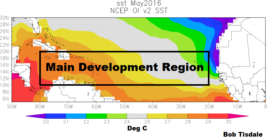
OVERVIEW
The Main Development Region of the North Atlantic (10N-20N, 80W-20W) is where hurricanes tend to form, although they can develop outside that region. See the National Hurricane Center Tropical Cyclone Climatology webpage, specifically the maps of their origins by 10-day periods. And the hurricane season runs from June 1st through November 30th.
Sea surface temperature is one of the many factors that contribute to hurricanes. The generally quoted the threshold for hurricane development and maintenance is 26 deg C (about 79 deg F). We recently illustrated the observed and modeled average annual cycle in the sea surface temperatures of the Main Development Region based on the averages for the past 30 years in the post Hurricane Main Development Region of North Atlantic – Climate Model-Simulated Sea Surface Temperatures Are Too Cool. I’ve removed the model curve in Figure 1 so not to distract from this discussion.

Figure 1
As illustrated, the most-recent 30-year average shows sea surface temperatures for the Main Development Region above the threshold of 26 deg C for most of the year, from late April to late December. And we can see that surface temperatures typically peak there in September and October.
SEA SURFACE TEMPERATURES AND ANOMALIES AT THE START OF THE 2016 SEASON
There are a number of ways to show the current sea surface temperature values. Using the satellite-enhanced Reynolds OI.v2 data from NOAA, we can present the sea surface temperature anomalies, referenced to the WMO-preferred period of 1981-2010. See Figure 2. As shown, the June 2016 temperature anomaly is +0.35 deg C, which is above normal, but nowhere near record highs, even in the wake of the 2015/16 El Niño.

Figure 2
Another way is to present only the June sea surface temperatures from the start of the Reynolds data in 1982 to now. See Figure 3.

Figure 3
As expected, the June 2016 sea surface temperatures of the Main Development Region are above the 26 deg C threshold, but there’s nothing unusual about the reading at the start of this year’s hurricane season. In fact, sea surface temperatures for the Main Development Region were roughly the same back in 1983, in the wake of the 1982/83 El Niño. Now consider that the volcanic aerosols from the 1982 eruption of Mexico’s El Chichon should have lowered the 1983 value.
Updated versions of Figures 2 and 3 will be included in the Monthly Sea Surface Temperature Updates.
DATA AND SOURCE
The sea surface temperature data in this post is the original (weekly/monthly, 1-deg spatial resolution) version of NOAA’s Optimum Interpolation (OI) Sea Surface Temperature (SST) v2 (aka Reynolds OI.v2)…not the (over-inflated, out-of-the-ballpark, extremely high warming rate) high-resolution, daily version of NOAA’s Reynolds OI.v2 data, which we illustrated and discussed in the recent post On the Monumental Differences in Warming Rates between Global Sea Surface Temperature Datasets during the NOAA-Picked Global-Warming Hiatus Period of 2000 to 2014.
The source of the Reynolds OI.v2 data is the KNMI Climate Explorer.
Looks like overall there is a slight uptick, due most likely to the AMO that peaked around 2010, and is now heading back down.
Yes
Bob Tisdale, ever notice whenever you post one of your great essays, it gets huge amounts of “related articles” ?? I think WP likes you !! lol
P.S. “The generally quoted the threshold for hurricane development and maintenance is 26 deg C (about 79 deg F)…One too many THE’s ?
cheers
It should be noted that the MDR temperature anomalies graph starts in 1980, which was near the nadir of Atlantic tropical cyclone activity. This might give some the impression that the MDR temperatures are on the rise, whereas the chart is starting at period when they were probably at their lowest.
Yeah, It’s kind of like arbitrarily starting a graph in 1998 and saying that global temperatures stopped increasing while not really looking at the entire data record going back 100 years and reaching different conclusions.
Yawn. We’ve heard this stuff before Dennis. Do you actually have anything to contribute or are you just here to troll?
..Why don’t we start at 10 million years ago so we can see the obvious pattern that man has no control over ? Alarmists don’t like that..I wonder why ?
When we look back 500 years, we reach a different conclusion, albeit probably more accurate. The problem is defining the sample size to spot the long-term trends when we don’t have good data until perhaps 100 years ago.
Mumbles McGuirck and Dennis Hlinka, if you had read and comprehended the post, which you apparently had not before commenting, you would have noted that the dataset presented is the satellite-enhanced Reynolds OI.v2 sea surface temperature data. It starts in November 1981. Get it?
SMC, Dennis Hlinka has trolled my posts for years.
As an aside, for those unfamiliar, official hurricane season begins June 1 and ends Nov 30. You will notice that on Fig 1, those dates coincide with SST at 26.7 C which is 80 F which I believe is the minimum temp threshold.
Yes. Minimum SST is 26.5C or 80F. Also necessary is low vertical wind shear and high midtroposphere humidity. And the seeding disturbance (line of thunderstorms formed in a low pressure ‘wave’) must be sufficiently far from the equator (about 500 km) for Coreolis force to be able to close it into a low pressure isobar (‘wave’ to ‘depression’).
Not to forget at least one agitated butterfly somewhere of the west African coastline.
“Not to forget at least one agitated butterfly somewhere of the west African coastline.”
Brilliant
I thought the agitated butterfly was in the Amazon.
ossqss
Brilliant video. Thanks for the laugh.
History and true meaning of the ‘butterfly effect’
https://youtu.be/aAJkLh76QnM
Just some Info: Al Gore Will Not Appear at Democratic National Convention
Breaking News at Newsmax.com http://www.newsmax.com/Politics/al-gore-hillary-clinton-dnc-climate-change/2016/07/25/id/740276/#ixzz4FR4MR1Bs
Too bad for Philadelphians and convention goers. Its pretty warm there. A couple of Gore-effect cool days would have been nice for them.
According to JB tweet this morning: “THE PROBLEM IN NOT THE MDR. ITS IN CLOSE TO WHERE IT COUNTS, THE US! Like 1950s ”
That the difference between an actual weather forecaster and someone like Bob Tisdale that pretends to be an atmopsheric scientist but is nothing more than an highly trained analyst that has no real understanding of the science.
So Dennis, are you just here for the ad hominem’s and trolling or do you actually have something to contribute?
Dennis Hlinka July 25, 2016 at 8:06 am
Dennis you are “cornfused”. You cannot be a highly trained “analyst” without having a real and comprehensive understanding of the subject matter.
Also I think your use of the word analyst is not a proper noun in the context you were implying.
I could be wrong.
michael
Judging by the crap he posts, Dennis seems to be a highly trained analist.
Assuming Dennis is the real deal and not an imposter, he is a Certified Consulting Meteorologist (CCM) with Sullivan Environmental Consultants. They apparently do a lot of work with the US EPA.
In other words, you’re pointing out that Dennis Hlinka is trolling here to protect his company’s green trough fundings.
That and the fact that Sullivan Environmental Consultants must be in a slow work period, (aka “on the beach” in contractor parlance), with nothing better to do; like learn more about sea temperatures or storm development…
Wow, Dennis. Nice to see you quoting Joe Bastardi.
Was I making a forecast, Dennis? No. This was a simple data presentation.
Does your employer know you waste their time with your blogging? Do your customers know?
Bob,
Again JB is a good weather forecaster, and I never questioned his forecasting abilities in that area. Where I have questioned him many times is when he stretches his discussions into climate science as his abilities in that particular area of science are lacking full understanding.
If you listen to JB the weather forecaster, the use of temperatures in the entire MDR you plan to use in your graph will be useless since most of the hurricane activity this year is expected to develop and strengthen in the NW Caribbean and very near the U.S. coastal areas due to the overall atmospheric pattern setting up. But since you are not a weather forecaster or have any a basic knowledge of meteorology, your decision to produce a data analysis over the entire MDR will prove nothing other than highlight your ignorance of why that is expected to occur.
That general lack of understanding of climate science that you display here quite often is related to the fact that you don’t have an atmospheric or climate science related degree (at least JB has one of those). Simply producing voluminous graphs of data without having any real understanding of the science behind that data highlights your ignorance. Numbers in your graphs don’t tell you everything, especially if you can’t relate it to the physics behind those parameters.
What is your real job experience in again before you did this online graphic exercise over the past decade or so? I really think the people here deserve to know what your working background was and how it relates to the subject of climate science. You apparently are really ashamed to summarize your working background anywhere despite the many requests to simply provide it. It must not benefit you to share that bit of information with anyone.
By the way Bob, my working hours are flexible and are not being hindered in any way in submitting comments to this blog site.
Wow Mr. CCM, you sure are smart with your fancy edumacation and sheepskin. I’m just a dumb hick from deliverance country wot graduated from the 8th grade.
Dennis, unless you are actually going to contribute meaningfully, take your ad hom’s someplace where they’ll be more appreciated, like 350.org…oh wait, they don’t get much traffic… hmmm, neither do any of the other CAWG sites… well there’s always the EPA, I guess.
SMC,
That type of childish response from you does nothing for your side of the argument if you really want to present any credibility on the subject. But why should I expect anyhting else.
I was really talking to Bob anyway and waiting for his response. If it is anything like his typical non-responses in the past, he will simply deflect the argument and go off on some tangential phonetic/spelling point because he has no answers on a subject he has no basic scientific knowledge in.
Dennis,
My responses are no more childish than yours. You’re supposedly a professional, act like it. If you have a problem with the arguments, data, information and analysis presented then demonstrate your competence by rebutting it in a professional manner. Present your counter arguments, data, information and analysis in a manner befitting the extensive education and experience you claim to have. Your ad hom’s are beneath you, or they should be.
dennis i see the shoot the messenger syndrome in your posts.
you know that these tactics are always used when you got nothing to rebut the actual message (the most important and relevant part by the way is not who is saying it but what is being said)
sorry when i read i wear always MAPBT-blocking glasses
younever heard of MAPBT? well it stands for “Meaningless Arguments Posted By Trolls”.
have a beer and enjoylife
cheers
Dennis Hlinka July 25, 2016 at 1:31 pm: “Bob,
Again JB is a good weather forecaster, and I never questioned his forecasting abilities in that area. Where I have questioned him many times is when he stretches his discussions into climate science as his abilities in that particular area of science are lacking full understanding.
If you listen to JB the weather forecaster”
So you troll Joe Bastardi, too?
What is the difference between a weather forecaster and a Certified Consulting Meteorologist?
Who made you the arbiter of Climate science qualifications?
I found your insulting post very annoying, insinuating that you have superior knowledge to Bob and Joe, but you couldn’t prove it by the content of your post. Just saying you are smarter than someone else doesn’t necessarily make it so.
TA:
Dennis is obviously trying to bolster his self confidence levels.
• Lots of fancy sophistry.
• Absolutely zero technical input on SST or storm development.
• Multiple ad hominems.
• Long wordy rambling sentences without substance.
• A rather obvious hatred for Bob Tisdale,
• a) Or is that better described as a consuming jealously?
Nor does the Dennis creature ever explain why someone must be a ‘forecaster’ to discuss SST or weather?
Or why excellent professional forecasters who have excellent track records should not discuss the myriad historical similarities to current events and what is expected to shape forecasted weather patterns?
A topic that is a prime reason Joe Bastardi drifts into pointing out CAGW prediction and attribution failings.
Note Dennis’s complete failure to accurately describe and rebut any particular anti CAGW statement; which brings us back to Dennis’s typical CAGW troll meme:
• ad hominems,
• vague claims of superiority,
• condescending prose and attitude,
• generalized not factual dismissal of skeptical points,
• total lack of facts,
• zero practical substance here, (and one wonders if anywhere).
The surface temp may be critical in the forming of an hurricane but is the layer below this important in its growth? Once wind speeds increase, there’ll be a corresponding increase in wave height and the amount of mixing going on , either sustaining , or snuffing out the storm.
I did a google search for hurricane statistics united states. The first item to pear was a CNN article from 2013. Didn’t see anything recent on the first page of hits. Does this mean that no one wants to cover the severe downturn or absence of hurricanes affecting the United States in recent years, because it doesn’t serve their purposes?
No news is a key strategy of the play makers and a gift from supposedly independent (but not) press.
“Does this mean that no one wants to cover the severe downturn or absence of hurricanes affecting the United States in recent years, because it doesn’t serve their purposes?”… Yep. The absence of CAT3+ hurricanes is directly counter to the CAGW meme of more frequent and more severe storms. Of course, when a CAT3+ hurricane does hit the US again, it’ll be trumpeted around the world as proof positive of CAGW. The ‘drought’ will be quickly forgotten.
“the difference between an actual weather forecaster and someone like Bob Tisdale ” ??
You either forgot the SARC tag or you are completely lost in the fantasy land of CAGW !!
A “weather forecaster” cannot get the predictions of 3 days in advance right…Yet this is what you compare Bob Tisdale to ?? On top of that, you “Climate Alarmists” keep saying weather is not climate, but 1 day of hot weather and you claim it is PROOF of CAGW , BUT , 1 day of record lows is just weather !….NUTS…….
Don’t forget about TCHP….
http://www.aoml.noaa.gov/phod/cyclone/data/intro.html
Methodologies have changed a few times so comparisons of such pre 2008 are not easy.
http://www.aoml.noaa.gov/phod/dataphod1/work/HHP/NEW/2016206at.jpg
It matters little to me when the data starts or what version it is. The mechanism behind the ups and downs of oceanic temperatures can NOT be attributed to increasing CO2 (no short term correlation). Furthermore, the underlying long term increasing temperature trend can NOT be attributed to increasing CO2. The only long term proxy data we have indicates that CO2 follows temperature rise.
It does matter to me regarding first and last data point use to show pauses and similar past behavior, or linear trend use to inform us on trending oceanic behavior. Globally, temperature behavior is defined by oscillations. If you want to know what those oscillations look like and possibly try to predict the next one either in the near or far future, straight lines are not the statistics that would be useful. That said, Bob’s use of both linear trend and first/last data point IS the statistic to use (among others) to determine if a step function is at work.
So far the Atlantic season is a dud. Accumulated Cyclonic Energy (ACE) although far from perfect, is 6 so far this year (with 3 coming from an outlier in January — yes January ! )– the yearly average is 110. You will read about how hot it is in the mainstream press but you won’t read about this. It would spoil the narrative.
These simple models which show a direct correlation between a warmer ocean and greater hurricane activity fail to account for the many other factors which can influence hurricane formation. Large areas of Sahara dust particles, large dry air masses, and wind sheer all can create a very hostile environment for hurricane formation. If these other natural processes were properly accounted for in the modeling process more accurate and reasonable estimates of the number and strength of Atlantic hurricane formation would occur. In today’s political world, where a few CO2 molecules are the cause of nearly all of mankind’s problems, modeling the actual physical atmospheric processes, unfortunately, is no longer about doing good scientific work if it doesn’t marry well with the AGW theory hype. If the Atlantic hurricane season turns out to be another bust, I’m sure there will be a multitude of “excuses” why the US did not get hit hard again.
The 2005 hurricane season is looking more and more like an anomaly.
luysii – I was about to post something similar.
We’re almost into August and the number of tropical disturbances in the tropical Atlantic have been stunningly low. I watch it closely because we charter sailboats in the Caribbean. Every time I have pulled up http://www.nhc.noaa.gov/ all I see is “Tropical cyclone activity is not expected during the next 48 hours.”
notonly the atlantic, the west pacific was really quiet till now it looks like getting some life now….
But here is the problem. I tweeted this and have outlined it dozens of times on weatherbell. THE SST near the US coast is similar to the period 1954-1960 when we only averaged 12 storms a year as the MDR did not have the kind of development that exploded near the east coast. We had 8 major hits on the east coast in 7 years with the sw atlantic very warm in those years. So my fear is that while you are correct, it may mean storms take their sweet time developing, but explode in the western basin. Of all those big hurricanes that hid, only Donna was strong in the MDR Most of the ace was late in the ball game west of 60 west. MDR storms are fun to watch, but its the ones that hit that are the big concern, and the SST in the gulf and east coast together are near warmest levels ever. A storm in those areas will not care if it came from the MDR or not, and in fact, many fast developing storms quickly recurve. I will have a public article that I can link tomorrow on this very matter and the political implications given any major threat will be blown out of proportion by the shameless tactics of the AGW ilk Peace
Well said Joe.
Last night, Destin, FL(on the Gulf Coast) had an overnight low “heat index” of 92 degrees.
I’m now less certain of the nature of the 2016 Season(what with Nino 3.4 in a cooling
pause). But anything that does develop nearshore, would seem to have great potential.
Sea Surface Temperatures
http://www.tropicaltidbits.com/analysis/ocean/cdas-sflux_sst_global_1.png
http://www.tropicaltidbits.com/analysis/ocean/nino34.png