Plus a Few Freebees at the End of the Post
Guest Post by Bob Tisdale
The sea surface temperature anomalies of the NINO3.4 region of the equatorial Pacific are bordered by the coordinates of 5S-5N, 170W-120W. They are used by NOAA and other meteorological agencies to define when an El Niño event is taking place. According to the most-recent weekly satellite-enhanced data, the temperature anomalies for that region have dropped below the +0.5 deg C threshold between El Niño and ENSO-neutral phases, the latter of which is the “normal” phase of the tropical Pacific when neither El Niño or La Niña are taking place.
The weekly NINO3.4 region sea surface temperature anomaly data for Figures 1 and 2 are from the NOAA/CPC Monthly Atmospheric & SST Indices webpage, specifically the data here. The base years for anomalies for the NOAA/CPC data are referenced to the WMO-preferred 30-year period of 1981-2010.
Figure 1 includes the weekly sea surface temperature anomalies of the NINO3.4 region. They start in January 1991. The weekly NINO3.4 sea surface temperature anomalies for the week of May 18 were +0.2 Deg C.

Figure 1
And for Figure 2, the evolutions of the NINO3.4-region sea surface temperature anomalies in 2015/16 are compared to 1997/98, another very strong El Niño. Recall that 2015 started the year at or near El Niño conditions, where that was not the case in 1997.

Figure 2
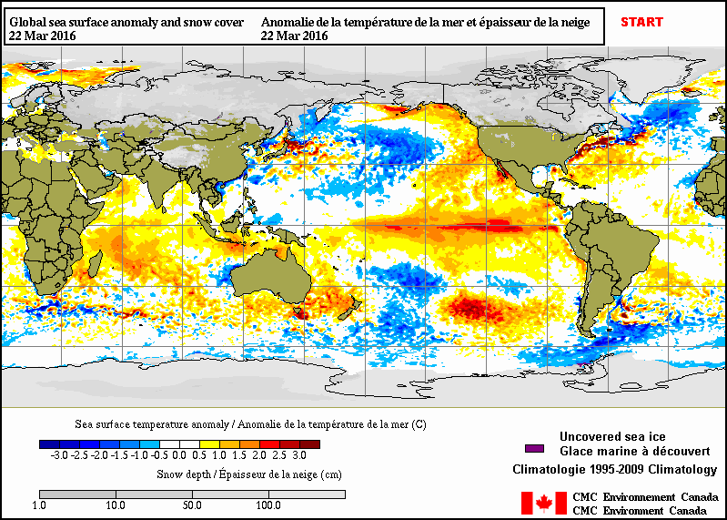
Figure 3 is yesterday’s sea surface temperature anomaly map from CMC Environment Canada. During this early phase of the transition from El Niño conditions, the negative anomalies are focused solely along the equator in the eastern tropical Pacific…east of about 150W. In other words, the sea surface temperature anomalies for the eastern tropical Pacific (24S-24N, 180-80W) as a whole are still elevated. Assuming the tropical Pacific will continue to transition to La Niña, and there’s a good chance of that happening, it will take a number of months before the rest of the positive anomalies depart in the eastern tropical Pacific.

Figure 3 (Source here.)
And for those interested, Animation 1 includes the last two months of sea surface temperature anomaly maps from CMC.
Animation 1
I’ll provide a full ENSO update in a week or two.
SOME FREEBEES FOR READERS
Toward the end of most of the posts included in the 2014/15 El Niño series and the 2015/16 El Niño series, I’ve advertised my ebook Who Turned on the Heat? – The Unexpected Global Warming Culprit, El Niño Southern Oscillation. I thank all of you who have purchased a copy of that very-detailed discussion of (1) the fascinating processes that drive El Niño and La Niña events and (2) the aftereffects of sunlight-fueled strong El Niños that cause global temperatures to rise naturally.
My ebook Who Turned on the Heat? – The Unexpected Global Warming Culprit, El Niño-Southern Oscillation IS NOW FREE. Click here for a copy (23MB .pdf).
ALSO
Climate Models Fail is another of my ebooks. Published back in 2012, it discussed the poor performance of climate models. It is also free. Click here for a copy.
Those of course are now added to my most-recent ebook On Global Warming and the Illusion of Control – Part 1, which was originally offered free of charge. Click here for a copy.
Slightly OT – I’m reading “the first three minutes” by Steven Weinberg. In it he comments that you cant define a temperature for a system that is not in equilibrium.
https://en.wikipedia.org/wiki/The_First_Three_Minutes
Most of you probably (a) read this book and (b) realised this fact about temperature a long time ago. I’m just catching up.
So – when discussing climate – the atmosphere and ocean that are both way far from equilibrium at all times – how come people talk about a temperature?
“- how come people talk about a temperature?”
Because talking about sex is considered rude and inappropriate. So the next thing that comes to mind is the weather.
“the atmosphere and ocean that are both way far from equilibrium at all times – how come people talk about a temperature”
Nothing is ever at equilibrium. But the concept of temperature is useful. Climate scientists didn’t invent it. Your body is not at equilibrium, but fever is worth measuring.
In the atmosphere, the concept you need for temperature is local thermodynamic equilibrium, which applies in the atmosphere until you get to high stratosphere.
Thank you for more free reading materials.
I assume the quality will be just as high as the more recent “On Global Warming”,
which I previously downloaded and read.
You are the most generous climate skeptic in the world.
So far I have noticed your writing contradicts the beliefs of the most famous climate “scientists” in the world:
Al Gore, President Obama, and the Pope — three noted “scientists” who tell us “the science is settled”, and are sometimes affectionately known as the Moe, Larry and Curly of climate science.
Al Gore took two science courses in college, and he almost got a B in one of them.
President Obama can read really well from a Teleprompter.
And the Pope once worked as a chemist, before he switched fields and became a Pope.
These three men are obviously highly qualified to make accurate predictions of the climate 100 years into the future.
Do you have any climate predictions for the next 100 years?
It’s not about prediction accuracy or science, it’s who you know.
Actually, I think its how much attention you get from the mass media.
Today I was at a car dealership buying a new car.
It was about 70 degrees, with pure blue skies that are not that common in Michigan, and there was low humidity and a small breeze.
To me the weather could not get any better today.
If I called the local newspapers and told them today was the best weather since I moved to Michigan in 1977 — and 2016 so far has been the best climate year in Michigan since the 1970s — they’d just hang up on me.
But if I told them I was a climate scientist, and my new study proved conclusively that climate change is positively correlated with the libido of women over 40, and negatively correlated with the crime rate in Detroit, reporters and cameramen would be knocking at my door.
A good story told well — politicians are good at that — and repeated frequently — becomes a headline, and headlines are the “truth” to many people (once a leftists knows the “truth”, you can’t pry it out of his brain with any logical argument, or even with a crowbar).
Sensible weather in Nor Cal is already like La Nina. We are having a cold spring.
What are the odds of a cold winter within A) one year later and B) two years later? (At least in the aftermath of major El Ninos and declines)
here the weather is not knowing what to do swapping from late spring to chilly fall moods.
Thank you, Bob, I’ve taken advantage of your generous offer.
A question to Mr. Tisdale.
What is the role of Lightening Strikes, across the equatorial pacific, on ENSO?
What is the role of Lightening Strikes on water in general?
See this:
http://www.nasa.gov/centers/goddard/news/topstory/2006/space_weather_link.html
In this image
http://www.vukcevic.talktalk.net/mb1.jpg
the plasma bands follow geomagnetic equator, while the three of the bright plasma pairs are areas with lots of thunderstorm activity, in this case were located over Africa, Indonesia and coastal region of South America.
Thanks for the image Vuks. Very good.
Check out the huge null point in the middle of the Pacific. Lots to see when you already have a few clues as to what you are looking at.
Uses a click and hold to move the map around.
http://maps.ngdc.noaa.gov/viewers/historical_declination/
Now if Dr. S., would provide a few ring current tips, the next adventure will begin..
So much new info pouring in.. and my brain has to get focused and disciplined elsewhere for a while. Develop good habits to help keep myself safe on the road.. under the new conditions..
http://oceantoday.noaa.gov/lightning/
When Lightening Strikes
Lightning is a rapid discharge of electrical energy in the atmosphere. Each spark can span over five miles in length, reach temperatures hotter than the surface of the sun and contain 100 million volts of electricity.
Lightning strikes are not only dangerous; they can be deadly.
The electrostatic discharge occurs within a cloud, between clouds, or between a cloud and the ground.
Lightning doesn’t strike the ocean as much as land, but when it does,it spreads out over the water, which acts as a conductor. It can hit boats that are nearby, and electrocute fish that are near the surface. …
Temperatures HOTTER than the sun?
Well I do see that NOAA is not in compliance “yet” with the https.
Why not go one step further? on Earth day let’s all leave the fridge door open for and hour. See it’s easy!
Well the Mediterranean isn’t the Pacific Ocean (equatorial region) but this is interesting none the less…
Lightning in the Mediterranean and its relation with sea-surface temperature
V Kotroni and K Lagouvardos
Published 1 March 2016
OPEN Access
Abstract
Here we present the analysis of lightning activity over the Mediterranean, based on a 10 year long dataset (2005–2014) provided by the ZEUS long-range lightning detection system. The major hot-spots of lightning activity are identified, with a clear predominance during the warm period of the year over land in the vicinity of the major topographic features of the area. Special emphasis is also given on the discussion of the seasonal distribution of lightning. In addition, we investigate the relationship of lightning with sea-surface temperature, obtained by high-resolution satellite measurements and we conclude that
the number of lightning strokes is positively correlated with the sea-surface temperature during autumn when also the maximum lightning activity over the sea is depicted.
We suggest that higher sea surface temperature further destabilises the lower tropospheric layers, enhancing thus convection and therefore lightning.
http://iopscience.iop.org/article/10.1088/1748-9326/11/3/034006/meta
Hi Carla
Sorry about your job, Dr. S lives in Petaluma Ca, don’t know if that would have been a +.
Thanks for the link. I often spend end of August and early September in the area (first map, red coloured area) just across the lower part of Italy. Thunderstorms in the hillsides are an experience not easily forgotten, we have to unplug all electric appliances, switch off all lights; there are frequent sparks and loud cracks on the wall sockets and neon lights momentarily light up. My daughter, when she was little, use to hide in a wardrobe.
Several interesting studies on the effects of lightning on SST.
The recent BARREL (Balloon Array for Radiation-belt Relativistic Electron Losses) experiment you may find very interesting, not just for the update on how reconnection is occurring, but on the bonus they discovered in being able to differentiate between, solar energetic electrons and radiation belt electrons. Which should be of interest also to the GCR community….
NASA mini-balloon mission maps migratory magnetic boundary
May 19, 2016 by Sarah Frazier
…….”Scientists have known that the open-closed boundary moves, but it’s hard to pinpoint exactly how, when, and how quickly it changes – and that’s where BARREL comes in. The six BARREL balloons flying during the January 2014 solar storm were able to map these changes, and they found something surprising – the open-closed boundary moves relatively quickly, changing location within minutes.
BARREL was designed to study how electrons from Earth’s radiation belts – vast swaths of particles trapped in Earth’s magnetic field hundreds of miles above the surface – can make their way down into the atmosphere. The BARREL campaign is primarily tasked with supplementing observations by NASA’s Van Allen Probes, which are dedicated to studying these radiation belts. However, solar energetic electrons happen to be in the same energy range as those radiation belt electrons, meaning that BARREL can see both.
“The scientists used balloon observations of solar particles entering Earth’s magnetic field to locate the outer boundary of Earth’s magnetic field, many tens of thousands of miles away,” said David Sibeck, a space scientist at Goddard and mission scientist at NASA for the Van Allen Probes. “This isn’t what BARREL was intended for, but it’s a wonderful bonus science return.”
http://phys.org/news/2016-05-nasa-mini-balloon-mission-migratory-magnetic.html#nRlv
Those electrons are becoming about as pesky as the GCR. CIRs and inbound waves to suns corona come to mind here, also….hee hee
Only joking about CA. Did notice 3 courier positions open in Pet.. and lots more in CA than any other state? odd
DOT physical and Drug screen tomorrow, for local FedEx ground here, nice country route in a newer vehicle.
Very interesting reading the forecasters in this thread and warmly comforting in the same way that listening to BBC Radio 4 shipping forecasts late at night is comforting.
The general synopsis at 23:00
High Bailey 1026 expected just northeast of Faeroes 1032 by 1800 Tuesday
The area forecasts for the next 24 hours
Viking
Northerly 5 to 7, occasionally gale 8 later in east. Moderate or rough. Fair. Good
North Utsire
Northerly 6 to gale 8. Moderate or rough. Fair. Good
South Utsire
Northwesterly 5 to 7, occasionally gale 8 at first in west. Moderate or rough. Showers at first. Good
Forties
Northerly 5 or 6, occasionally 7 in east. Moderate or rough. Fair. Good
Cromarty, Forth, Tyne
North or northeast 4 or 5, occasionally 6 later. Slight, becoming moderate. Fair. Good
Dogger
Northerly 5 or 6, occasionally 7 in east. Moderate or rough. Fair. Good
etc.
Unlike the shipping forecast which is good for a few hours only I have little faith in any of the longer term forecasts based on ocean temperature states. I don’t know that I am in fact justified in my disturbing lack of faith because I’m not a forecaster but would be interested in the forecasting track records of those who purport to have knowledge of these things. Or is it more a case of weather-beaten old sea dogs in oilskins and sou’westers sucking on pipe stems and saying ‘aaaarh’ a lot?
Many charts show a slight step increase in mean global temp after the 98 El Nino. It will be interesting to see if this is the case this time round.
Dear Bob
I found if I cut and pasted the Figure 1 Nino 3.4 SST anomalies at about 2009 -present and superimposed that over 1990 – 1998 so the major peaks match, then the two are virtually identical in terms of timing of max and mins. What I found particularly intriguing was the duplication of the little shoulder on the two first semi-major peaks viz approx. 1992- and 2009+ even concurred to appear as virtually identical. Perhaps this is accidental but coupled with the overall synchrony, me thinks such apparent fine detail may deserve a more careful explanation that mere coincidence.
I for one am glad El Niño is fading. We got about four inches of El Niño overnight here in south Texas….
Figure 1 shows twenty five years with no SST warming in the ENSO area. In the meantime atmospheric CO2 has risen about 10% from ± 360ppm to ±400ppm.