Guest post by David Middleton
I was going to debunk this bit of nonsense from New Scientist, but it never identifies the vanishing islands and kind of debunks itself…

Going, going, gone. Five of the Solomon Islands have been swallowed whole by rising sea levels, offering a glimpse into the future of other low-lying nations.
Sea levels in the Solomon Islands have been climbing by 7 millimetres per year over the last two decades, due to a double whammy of global warming and stronger trade winds.
“It’s a perfect storm,” says Simon Albert of the University of Queensland. “There’s the background level of global sea-level rise, and then the added pressure of a natural trade wind cycle that has been physically pushing water into the Western Pacific.”
The global rate of sea level rise is 3 millimetres per year, but is likely to accelerate to 7 by the end of the century, as rising temperatures melt ice sheets and cause thermal expansion of the oceans, Albert says.
“All the projections show that in the second half of the century, the rest of the globe will reach the rate of sea level rise that the Solomon Islands is currently experiencing,” he says.
Albert and his colleagues analysed aerial and satellite images from 1947 to 2014 to study the effects of creeping sea levels on the coastlines of 33 reef islands in the Solomons.
Five islands present in 1947, ranging in size from 1 to 5 hectares, had completely disappeared by 2014.
Another six islands had shrunk by 20 to 62 per cent in the same period, confirming anecdotal reports of people living in the area.
[…]
Hoping to find out which islands had vanished, I clicked this link: of creeping sea levels on the coastlines…

Rising seas are eating away at small islands and will eventually turn their inhabitants into climate refugees, right? Not so for some of the world’s most threatened islands, which have grown despite experiencing dramatic sea level rise.
Funafuti atoll, which includes the capital of Tuvalu, is an islet archipelago in the tropical Pacific Ocean made from coral debris washed up from an underlying reef by waves, winds and currents. Over the past 60 years the sea has risen by around 30 centimetres locally,sparking warnings that the atoll is set to disappear.
But Paul Kench of the University of Auckland, New Zealand, and colleagues found no evidence of heightened erosion. After poring over more than a century’s worth of data, including old maps and aerial and satellite imagery, they conclude that 18 out of 29 islands have actually grown.
As a whole, the group grew by more than 18 hectares, while many islands changed shape or shifted sideways.
“There is still considerable speculation that islands will disappear as sea level rises,” says Kench. “Our data indicates that the future of islands is significantly different.”
Storms and other disturbances that churn up the sea seem to be more important than sea level in influencing stability, says Kench. Storms break up coral, which then gets deposited on the atolls. He says other coral reef islands are likely to evolve in the same way, and that the Maldives seem to be showing a similar effect.
“There is presently no evidence that these islands are going to sink,” says Virginie Duvat of the University of La Rochelle in France. She says that she and other researchers are trying to fight the widespread misconception that sea level rise will mean the end for atolls. However, Kench’s findings do not apply to other types of island, like the volcanic main islands of Fiji, Tonga and Samoa.
[…]
Having lost patience for finding the lost islands, I moved on to the 7 mm/yr bit.

Does this look like 7 mm/yr? Let’s check.
I get 6 mm/yr with R² = 0.2. A trend of less than 1 cm/yr with a cyclical variation of nearly 50 cm… Not exactly a robust trend.

Any islands vulnerable to 6 mm/yr of sea level rise would have already been vanishing during most El Niño episodes.
Then I moved on to the moronic claim that sea level “is likely to accelerate to 7 (mm/yr) by the end of the century…

A massive rise in sea level is coming, and it will trigger climate chaos around the world. That was the message from acontroversial recent paper by climate scientist James Hansen. It was slated by many for assuming – rather than showing – that sea level could rise between 1 and 5 metres by 2100.
But now, just a week after being formally published, it is being backed up by another study. “He was speculating on massive fresh water discharge to the ocean that I don’t think anybody thought was possible before,” says Rob DeConto of the University of Massachusetts Amherst. “Now we’re publishing a paper that says these rates of fresh water input are possible.”
[…]
This idiotic claim is based on RCP 8.5. It is not a “likely” case. It is a “worst possible” case based on practically impossible assumptions.
Oh Noes!!! Sea Level Rise to Double… Again!
RCP 8.5: The “Mother of all” Junk Climate Science
RCP 8.5, Part Deux: “The stuff nightmares are made from.”
I finally did manage to find the five sunken islands. CNN had a link to the ERL paper.

Looks like this post will have a sequel.
The “lost islands” are presumably due to the natural “shifting sideways” aspect of coral atolls, as described in the other linked report: “As a whole, the group grew by more than 18 hectares, while many islands changed shape or shifted sideways.”
Every time an island shifts (“shoreline recession at two sites has destroyed villages…”) they count it as lost land while ignoring the newly accreted land the the village has moved to.
Back in the 1960s the top warmists of the day predicted that sea level would rise 10 feet by the year 2000. They also predicted another 200 feet of sea level rise by 2200, or an additional 1 foot per year.
If the nightmare scenario is now 7 mm / year, that is a stunning reversal from the alarmism of the past.
http://iopscience.iop.org/article/10.1088/1748-9326/10/8/084024
Sea level rates up to three times the global mean rate are being observed in the western tropical Pacific since 1993 by satellite altimetry. From recently published studies, it is not yet clear whether the sea level spatial trend patterns of the Pacific Ocean observed by satellite altimetry are mostly due to internal climate variability or if some anthropogenic fingerprint is already detectable. We show that subtraction of the IPO contribution to sea level trends through the method of linear regression does not totally remove the internal variability, leaving significant signal related to the non-linear response of sea level to El Niño Southern Oscillation (ENSO). In addition, by making use of 21 CMIP5 coupled climate models, we study the contribution of external forcing to the Pacific Ocean regional sea level variability over 1993–2013, and show that according to climate models, externally forced and thereby the anthropogenic sea level fingerprint on regional sea level trends in the tropical Pacific is still too small to be observable by satellite altimetry.
Furthermore, regressed CMIP5 MME-based sea level spatial trend pattern in the tropical Pacific over the altimetry period do not display any positive sea level trend values that are comparable to the altimetry based sea level signal after having removed the contribution of the decadal natural climate mode. This suggests that the residual positive trend pattern observed in the western tropical Pacific is not externally forced and thereby not anthropogenic in origin. In addition the amplitude of the sea level spatial trend pattern from regressed CMIP5 MME is low over the altimetry period in the tropical Pacific. This amplitude is significantly lower than the expected error in trend patterns from satellite altimetry (in the order of 2 mm yr-1 to 3 mm yr−1, Ablain et al 2015, Couhert et al 2015) and suggest that satellite altimetry measurement is still not accurate enough to detect the anthropogenic signal in the 20 year tropical Pacific sea level trends.
http://onlinelibrary.wiley.com/doi/10.1002/2015JC010716/full
Global sea levels have been rising through the past century and are projected to rise at an accelerated rate throughout the 21st century. This has motivated a number of authors to search for already existing accelerations in observations, which would be, if present, vital for coastal protection planning purposes. No scientific consensus has been reached yet as to how a possible acceleration could be separated from intrinsic climate variability in sea level records. This has led to an intensive debate on its existence and, if absent, also on the general validity of current future projections.
Interesting study KR.
“Next to the 2011a study of Houston and Dean, Watson [2011] reported decelerating rather than accelerating tide gauge series along the Australian coastline.”
The best “trend pattern” to use that I know of is personal observation and in my relatively geodetically stable NOTW on the Australian coastline for the last 70 years highest astronomical tides during fine weather [~ normal BP] based on AHD100 sea wall heights, these king tides have dropped on average ~ 150 mm [6 inches] in that time.
So, not only no acceleration but straight out NO SLR AT ALL !!!
Put the Chinese in charge of island raising.
) It’s usually politicAL.
Indeed one needs to know which “islands”.
Some are really sandbars, which are at the mercy of wave action.
Some disappear when the earth below sinks, I understand that’s the case in Hawaii, where new ones are also formed (volcanic action there).
Some locations on the mid-wet coast of North America are sinking while others rise – compare long-term records from PSMSL for New Westminster BC and the corner of WA state (La Push or thereabouts).
In https://wattsupwiththat.com/2016/05/08/gang-aft-agley/ Willis E says “Naw, the claim was about the Solomon Islands, and it was just small uninhabited barrier sand islets. These are constantly shifting and changing, with old ones disappearing and new ones appearing.”
Reblogged this on Climatism and commented:
Since the end of the last ice age, The Marshall, Solomon and other Island atolls have survived 130 metres of sea-level rise, but the last 1.43mm/year since 1950 (if that) is going to sink them?!
Climate reports based on RCP8 Climate model predictions are a disgrace to journalism and science.
They depict the opposite of observed reality and epitomise the fear mongering, propaganda and alarmism that fuels the ‘catastrophic (man made) climate change’ scam.
More “scientific” proof of my above statement here:
https://climatism.wordpress.com/2013/09/04/44th-pacific-sinking-islands-extortion-forum/
An honest question: Did anybody actually live on them?
(Haven’t the Chinese and others made up for their loss?8-)
If they are gone because of actual CAGW sea level rise. then why Is Tuvalu still there?
In this layman’s opinion, baring plate tectonics and all that, some islands are sand and some are rock. How many of the rock ones are gone?
David Middleton writes: “Any islands vulnerable to 6 mm/yr of sea level rise would have already been vanishing during most El Niño episodes.”
Your graphs of sea level variations for the Solomon Islands show sea level dropping there during El Nino events, which is appropriate for the western tropical Pacific. Shouldn’t your statement end “…during most La Nina episodes”?
Cheers.
I will defer to the ENSO expert on that one.
Would the sudden recent drop be a potential harbinger of the next La Niña?
Yes it should. Sea level in the Western Pacific rises during La Niña episodes.
It just keeps happening. We’re losing several sandbars every year due to sand getting washed away.
And in this instance we lost maybe half a square kilometer of useless nothing. Probably due to erosion.
Nobody was hurt. Nobody will miss this sand.
Here’s a previous example of sand bar loss, from March 2010.
https://wattsupwiththat.com/2010/03/25/bengal-island-succumbs-to-global-warming-nonsense-ap-gets-nutty-over-loss-of-a-sandbar/#more-17685
@ur momisugly indefatigable, I have a suspicion it is why Holland builds dikes. (They actually turn those initial sand bars “polders” into farm land.)
Ahh “sandbars into “polders then into farmland”, ( brain way faster than fingers)
Precisely. But the eco-left despise all “interfering with nature”.
Reclaiming land from the sea is appropriation of territories belonging to aboriginal fish – or something like that!! 🙂
Don’t you just.love it how “global sea level rise” picks out islands? One. By. One…
Slightly off-topic, but I would strongly recommend this article on a similar-ish situation in the Sunderbans:
“Those set to lose their land were certainly suffering. But no one blamed rising sea levels. They blamed the government’s unwillingness to spend money on a proper concrete breakwater, and the shortsightedness of the well-meaning philanthropists who had settled them there over the last 100 years.”
http://www.spectator.co.uk/2010/02/story-of-a-sinking-land/
What’s the rate of subsidence?
What’s the rate of erosion?
What’s the effect of the variable easterlies on sea level?
???????
Unknown ×3
Throughout the last 40 years There has been 21 earthquakes measuring 6.5 MW and above in the Solomon Island region. Some have measure over 8 MW
I have had a glance at the bathymetry using Goggle Earth. It is clearly a very dynamic tectonic region. Some islands are just pinnacles on ridge systems that rapidly drop off to several KM water depth within 10 km
Yes, it is part of a tectonic boundary – a complicated one at that. Relative sea levels will be highly dynamic, up or down. Without measuring tectonic displacement any data on relative sea level is useless
The disappearing island story featured on New Zealand National Radio news.
Any mention of the massive coral bleaching event this year? No didn’t think so.
yes consistently, we have a few threads for that, debunked. Deal with it.
Debunked? Really? Get in a plane, fly over to north Queensland, hire a charter and see for yourself (Queensland is in A-u-s-t-r-a-l-i-a btw). You are clearly a moron Mark.
friends just got back from Cairns. diving on the reef is great. if there is bleaching it isn’t widespread.
in any case, coral bleaching is a natural process. coral is a symbiont. a polyp and an algae. the algae gives the color. when the algae isn’t producing enough food, the polyp kicks it out and waits for another algae that will produce food.
sort of like humans. the dad isn’t supplying food, the mom kicks him out and looks for a replacement that will. the reason is much the same, both are trying to increase their reproductive success.
In point of fact, new research indicates that coral is not a symbiont in the traditional sense. Rather, the coral “farms” the algae, using a chemical signal to attract the normally free swimming algae.
the reason the coral does this is the tropical waters are nutrient poor. the algae provides the coral polyps with energy (sugars) via photosynthesis. in return the waste products of the coral help nourish the algae, providing for example CO2 and nitrates.
I know it’s a pointless exercise trying to explain (a) geography (b) climate science and (c) common sense on here- but for f*** sake educate yourself. First, a tour operator is not going to take a bunch of fat american tourists to a dead reef. Second, the worst bleaching has occurred further north of cairns. Third coral bleaching events on this kind of scale are not “natural” events.
Here’s multiple private and public media sources including some s*** right wing ones detailing the extent of this disaster so don’t give me any predictable crap about this being a left wing conspiracy:
http://www.foxnews.com/science/2016/03/30/great-barrier-reef-hit-by-widespread-coral-bleaching.html
http://www.abc.net.au/news/2016-03-28/great-barrier-reef-coral-bleaching-95-per-cent-north-section/7279338
http://www.theguardian.com/environment/2016/apr/19/great-barrier-reef-93-of-reefs-hit-by-coral-bleaching
http://www.dailymail.co.uk/news/article-3586655/Great-Barrier-Reef-trouble-hundreds-kilometres-coral-bleached-dead.html
http://edition.cnn.com/2016/04/20/asia/great-barrier-reef-coral-bleaching/
http://www.scientificamerican.com/article/bleaching-hits-93-percent-of-the-great-barrier-reef/
Hey Mike !!
Are you lost? the Granuiad is >>>>> that away
Great Photo, The cat would have more brains as well.
So nothing intelligent to say then? Didn’t think so. Morons.
The current coral bleaching episode is 100% due to the current El Niño event. When faced with sudden increases in water temperature, coral switches out its algal zooxanthellae.
Bleaching events were common in the early 20th century, uncommon during the mid-20th century cooling period and then common again since 1980…
The Gorebots routinely ignore everything prior to the early 1980’s bleaching events and declare this to be unprecedented.
wonder what Paul Kench would have to say about that.
https://www.researchgate.net/profile/Paul_Kench
So familiar have I become with the climatariat and the dreggy media behind it that I knew these islands would not exist and I moved on without inquiry or interest.
At the height of the Cold War a dissident visiting the West expressed amazement that the western media conformed and propagandised on behalf of the establishment without being subjected to any threat of persecution, violence or worse. They’re volunteers.
They’re volunteers.
==========
no. the media is owned by the establishment and the reported are paid to propagandize on behalf of the establishment.
WaPo assigns 20 reporters to “get the dirt” on Trump. Why just trump? Why not get the dirt on all the candidates?
This isn’t reporting. It is politics dressed up as news, to gain political advantage. Because with political advantage comes control of the purse strings of government.
Does anyone seriously believe the establishment will spend $1 billion dollars in support of a candidate without expecting to get much more back in return?
Good reason the American People are pizzed off with their political system. They have been led through the nose from one disaster to the next, as they spend trillions of dollars and tens of thousands of lives to “police” the world.
Look at the latest disaster. Regime change in Syria, led by the CIA and Hillary in the State Department, Obama as the salesman. Assad must go. The US set this as a precondition to peace talks.
Instead after years of fighting Assad is still there, and now there is ISIS. Moscow and China on the rise with a refugee crisis in Europe and around the world.
For many, many people of the world, Climate Change isn’t the greatest threat to world peace. All too many people see America foreign policy as the greatest threat.
Hasn’t the time has come to stop trying to be the policeman to the world? because as a policeman you end up owning all the worlds problems. it becomes your responsibility to solve them, and you get blamed when you can’t.
A correlation coefficient of 0.2 is called random noise. It has to be 0.7 or higher to be relevant, namely, worth talking about at all as indicative of something in natural systems.
Hopefully people will naturally grasp that it depends on how many pairs of factors a person has examined as potential correlates.
Imagine that I have two good dice, and I threw them 100 times. If I showed a weak correlation between throws, then something clearly fishy would seem to be afoot, and it would justify further examination.
But, if I threw 100 dice, 100 times, and then found a weak correlation between the values given by two dice, picked by me from the entire group of 100 dice – then hopefully most people would spot that this comes as no surprise. And that I have not discovered an interesting phenomenon.
i.e. because of the way that I picked my correlating data from a much larger pile of discarded data, removes the significance of the correlation.
Climate Scientists have more than 100 dice to play with. The modern age can provide them with vast quantities of data from all kinds of events. The fact that they can mine that data for weak correlations should come as no surprise.
This would be the case – even if all data was randomly generated.
A simple example of this error – is the claim made by alarmists that the end of freezing of the Thames (1814) was caused by the removal of London Bridge (1831).
Many people have spoofed such poor quality thinking about spurious associations/correlations.
My favourite, is here:
http://wmbriggs.com/post/4423/
in an infinite universe, there are an infinite number of positive examples that can be used to prove anything. truly, if you look, you will find an infinite number of example to prove anything. purple jelly beans cause cancer. women’s hemlines drive the stock market.
the only “proof” of the truth lies in the negative example. but these studies never get published because they are not interesting. “we looked and found nothing” does not sell news stories.
the truth is obscured by publication bias. negative results don’t get published, but these are the results that truly matter.
The Pause” was the most significant climate event in the past 20 years. Yet it went unnoticed in scientific publications, because if was a negative example. It showed nothing was happening.
In contrast, Karl’s Pause Buster received more press for a single positive finding, than was given all the negative findings for the length of the Pause.
It falls a bit shy of 6σ… /sarc
It falls a bit shy of 6σ… /sarc
‘Team member Roger McLean of the University of New South Wales in Sydney, Australia, who is also a coordinating lead author on the small islands chapter in the latest Intergovernmental Panel on Climate Change report, says the paper’s findings are important because of the time frame. The sea level change at Funafuti over the past century is similar to what the IPCC is projecting for the year 2100.
“There will be less emphasis on external migration of ‘environmental refugees’ from atoll nations that has gained such prominence in the last few years,” he says. But he notes that the atoll-building sediment comes from productive coral reefs, which face a range of threats such as warming oceans and pollution.’
Always that BUT….
And just who was it that put such emphasis and prominence on all those ‘environmental refugees’ in the first place Dodger?
Many of the reefs that supposedly disappeared in 2014 are visible above the surface in some 2015 and 2016 Landsat images. Here is Kale: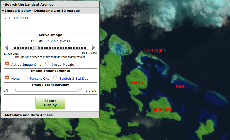 .
.
As you could expect, low reefs are partially above, partially below the surface depending on shorter-term fluctuations such as tides and ENSO. You can’t use individual images from different decades to draw conclusions about the millimeter-per-year long-time trend that’s supposedly partially related to AGW. Daily to decadal fluctuations are larger than the long-term change of half a century.
The authors clearly understand this and maybe that’s why they’ve apparently avoided falsifiable hard claims in the paper and made them in blogs instead. https://wattsupwiththat.com/2016/05/10/busted-claim-data-shows-that-climate-induced-sea-level-rise-didnt-wipe-out-five-solomon-islands/#comment-2212136
The sharp drop in sea level, associated with this El Niño, undoubtedly resurfaced some of the sunken islands.
Sea level in the Western Pacific actually falls during El Niño episodes.
I’ve looked into the ‘Five Islands’ in a bit more detail. You can see my comments at:
http://www.climatedata.info/discussions/blogger/
My main conclusions are:
1. The total area of the 5 islands is only 0.0006% of area of the Solomon Islands.
2. 40% of the loss occurred in the 1947 to 1962 period.
You can not jump to conclusions about sealevel rise unti you know what the underlying seafloor is doing.
from the below linked Article:
“The sea level around Antarctica and Greenland will be going down; Scandinavia will be emerging. Almost every projection I have seen shows the highest rates of rise will be in the equatorial Pacific,”
http://www.independent.co.uk/environment/climate-change/sweden-the-land-of-the-rising-coastline-8373787.html
For the Solomon Islands the rate of sinking of land (Glacial Isostatic Adjustment) is of the order of 0.16 mm/year. An order of magnitude less than the rate of sea level rise.
I invite everybody to an Island Birthday Party. Just wait six hours till the tide goes out. Hip Hip Hooray.
Only 5 islands in the Solomons had completely disappeared since 1914, 1 to 5 hectares in size. That’s remarkably low, must be because most islands are rising in line with rising sea levels. This offers a glimpse into how insignificant sea levels rises will be over the next 100 years.