From the UNIVERSITY OF MINNESOTA and the “any motorcycle or bicycle rider can tell you this” department comes this study on UHI in Minneapolis.
Results provide valuable insights into efforts to reduce heat-related harm in metro areas globally

Some parts of the Twin Cities can spike temperatures up to 9°F higher than surrounding communities thanks to the “urban heat island” effect, according to a new study from the University of Minnesota.
The study, which was funded by the Institute on the Environment and published in the Journal of Applied Meteorology and Climatology, used a network of 180 sensors deployed throughout the Twin Cities metropolitan area in residential backyards and city parks to paint the most detailed picture anywhere in the world of how temperature varies with time and place across pavement-filled metropolitan areas and surrounding communities.
Recording surface air temperatures every 15 minutes from August 2011 through August 2014 across nearly 2,000 square miles and using U.S. Geological Survey data to fine-tune differences at the neighborhood level, the study uncovered several surprises. Among them:
Temperatures in the urban core of Minneapolis, St. Paul and Bloomington average 2 °F higher in summer than in surrounding areas
The differential spiked as much as 9 °F higher during a heat wave in July 2012
Urban heat island effect is stronger at night in summer and during the day in winter
In urban areas during the winter when snow cover is less pervasive, temperatures are higher than rural areas in the daytime by an average of 2 °F.
“We’ve long known that heat radiated by buildings, roads, bridges and other structures keeps surface air temperature higher in cities than in surrounding areas. However, temperature is officially measured at just a few locations in most cities, so awareness of the extent and variability of urban heat island effects was limited,” said lead author Brian Smoliak. “Our study highlights the usefulness of dense sensor networks for urban weather and climate research with practical implications for human health, energy consumption, and environmental quality.” Smoliak began the project as a postdoctoral researcher in CFANS and is now an atmospheric scientist at the Climate Corporation in Seattle, Washington.
The more detailed understanding of urban heat islands provided by the study can help health professionals and others target efforts to protect people and infrastructure from heat-related problems, according to project co-leads Tracy Twine and Peter Snyder, associate professors in the College of Food, Agricultural and Natural Resource Sciences.
“This level of detail in real time can provide specific information to agencies tasked with protecting our citizenry during extreme heat events,” Snyder said. “It can also be used to identify persistently warm areas of the metro where green infrastructure projects could be implemented to offset some of the warming.”
###
The University of Minnesota’s Institute on the Environment seeks lasting solutions to Earth’s biggest challenges through research, partnerships and leadership development. For more information, visit environment.umn.edu.
Paper: Brian V. Smoliak et al. Dense Network Observations of the Twin Cities Canopy-Layer Urban Heat Island*, Journal of Applied Meteorology and Climatology (2015). DOI: 10.1175/JAMC-D-14-0239.1
| Abstract |
|---|
Data from a dense urban meteorological network (UMN) are analyzed, revealing the spatial heterogeneity and temporal variability of the Twin Cities (Minneapolis–St. Paul, Minnesota) canopy-layer urban heat island (UHI). Data from individual sensors represent surface air temperature (SAT) across a variety of local climate zones within a 5000-km2area and span the 3-yr period from 1 August 2011 to 1 August 2014. Irregularly spaced data are interpolated to a uniform 1 km × 1 km grid using two statistical methods: 1) kriging and 2) cokriging with impervious surface area data. The cokriged SAT field exhibits lower bias and lower RMSE than does the kriged SAT field when evaluated against an independent set of observations. Maps, time series, and statistics that are based on the cokriged field are presented to describe the spatial structure and magnitude of the Twin Cities metropolitan area (TCMA) UHI on hourly, daily, and seasonal time scales. The average diurnal variation of the TCMA UHI exhibits distinct seasonal modulation wherein the daily maximum occurs by night during summer and by day during winter. Daily variations in the UHI magnitude are linked to changes in weather patterns. Seasonal variations in the UHI magnitude are discussed in terms of land–atmosphere interactions. To the extent that they more fully resolve the spatial structure of the UHI, dense UMNs are advantageous relative to limited collections of existing urban meteorological observations. Dense UMNs are thus capable of providing valuable information for UHI monitoring and for implementing and evaluating UHI mitigation efforts.
In other words, they refuse to stop herding people into cities, they just resort to new ways to justify of extracting more taxes from the citizenry.
Megalopolis is the future. Read your Agenda 21.
Its beds, the size of beds, they are driving up temperature, junior, single, then double, large double, queen, king and super king!
Its beds I tell you, do away with them and temperatures will come down!
Its not ‘surprising’ because the problem is ‘upspringing’
The California Kings alone will cause an extra foot of sea level increase…
…and, oddly enough, that increase in nighttime temperatures happens to match the temperature predictions from AGW.
In a strange coincidence, a lot of studies toss out rural temperature stations while emphasizing urban ones.
Imagine that.
The airport is inside the hot spot area. There are three points indicated on the maps. It’s the lower one in the middle of the map just inside the ring road system which is pretty easy to see.
The upper left point looks to be DT Minneapolis, the upper right one is likely DT St. Paul.
Almost all GHCN station are now at airports.
The surface “Global Warming” record is largely this Airport Heat Island effect.
wrong. GHCN is not all at airports.
further. If you study Airport versus no airport using GHCN-D ( daily ) you will see No difference
except in Japan where airports have lower trends.
” If you study Airport versus no airport using GHCN-D ( daily )”
Isn’t GHCN adjusted to remove that difference?
This kind of sample-based study is useful because it provides actual data for others to use in their work. It’s unglamorous, but I commend the researchers who do the work.
Agreed.
Measuring things is the start of science.
They aren’t starting at the modelling phase. So they are doing this right.
Also agreed. not sure why the mocking comments above. These guys actually went out and measured the temperatures. they did actual scientific work and didn’t rely on guesses and models..
They did good. But I think I speak for everyone when I say they still need to be mocked. It’s a ruthless arbitrary world
Your point that measuring is the start of science is well taken. However, the last sentence of their abstract is quite disturbing: “Dense UMNs are thus capable of providing valuable information for UHI monitoring and for implementing and evaluating UHI mitigation efforts.” They simply assume that now that they have documented the UHI effect, it must be mitigated. Why? People that gather in groups tend to raise their surrounding temperatures. It’s simply science. Why does it need to be mitigated? I suspect that the answer is to keep the government money spigot open.
I’ll agree. While any motorcyclist or philosopher knows the basic trend, quantification is a good thing, and this was heavily sampled with lots of footwork. This should be commended.
YES!! I also commend them. More data is a good thing. Not a lot of political posing here.
I trust the sensors are located away from air conditioner exhaust, etc.
Avoiding AC exhaust kinda misses the point. They mention “back yards”. I’m in tropical north east Australia and some 15 years ago was asked to look into the UHI issue because residents were complaining about small “modern” back yards being unusable in the summer. All it needed was poor orientation, no shading vegetation because there isn’t room, solid fences, a few AC units feeding into the space, and you end up with food cooking on a barbeque when the gas has not been lit. Natural airflow starts to diminish when site coverage goes over 30% and is absent (skimming over the roof tops) when it gets to 40%. I wrote a design standard aimed at diminishing the risk, and it is still mandatory in this area.
Where can I find the info on those designs? (I am actually wanting to go the opposite way I’d love to have some extra heat living in Canada!).
There was an approval process for volunteers. You needed a big yard with air circulation. The sensor is on top of a 5foot high wood post. In my case the post is in the middle of a small flower garden.
Beautiful!!!
especially using cokriging with impervious area.
This will allow us to explain why UHI is so hard to find in a global monthly record.
My guess would be because the monthly record is adjusted down for UHI………
Its easy to find.. Its a good proportion of the small amount of warming we have had.
Just so long as “regional expectations” don’t smear it to rural area so everything is “homogenised” to that UHI warming.
Remove other unwarranted adjustments from Gavin , Best etc… and I doubt there has been much overall warming since the middle of last century.
If you can find it.. please publish. In the US maybe .1C was found.. otherwise… not much.
If you read the article carefully you will see why its hard to find.
By who? Best and Giss would NEVER be looking for it.
You really are a Dodgy Bros salesman, Mosher.
Still trying to sell a lemon.
Steven – are you disagreeing with the study’s findings?
As a resident of Mpls/St Paul – who regularly drives throughout and across the cities day and nite – I can generally affirm the findings based on real world observations.
Steven – the temperature variations due to UHI are real, and often significant. Can you explain to us – in laymans terms – why you, the Best team, etc. claim there is little or no evidence of UHI in the temp record?
So where are the official stations located on that map? That would give a good comparison of how high the official temps are biased.
The long term record is at the airport. The lower of the 3 dots on the figure.
We need someone to analyze that station and see how the adjustments to its results were done. If it is like most stations, we will see that the historic temperatures were reduced, while modern temperatures were raised. This really could be the smoking gun!
Jeff in Calgary – spot on, it is opportunity to demonstrate the bias in the adjustment methodology
One reading for every 11+ square miles, i.e. 11+ sections.. There are “section roads” in the twin cities area. Some have filled in with buildings. They pretty much pegged the heat islands I recall, but have to wonder how well and evenly the other areas were covered. There are a lot of lake and marsh areas. I’d be a lot more convinced if they had about 10 times as many nodes.
‘The study, which was funded by the Institute on the Environment and published in the Journal of Applied Meteorology and Climatology, used a network of 180 sensors”
( from the article)
Not sure what what kind of “nodes” you mean Mib8 , a 180 sensors sounds pretty dense to me, not saying I agree with the conclusions but I think they at least tried to cover the area.
True, but funding is limited. I’m surprised they were able to get such thorough coverage as they did. 180 sensors is a lot for one team to distribute and work with. Though an order of magnitude more would be wonderful, that’s a pipe dream.
Lovin Spoonfuls, Hot Town, Summer in the City
https://youtu.be/m648v4s5sFc
Always loved that song from when I was working in Diamond A bean factory in Eugene Oregon in 1966. 6PM to 6Am every night for the summer and heard this song on the radio every night during break. Also tried to work in the fields with the migrant workers that summer, but could not compete with the families working there. Only earned $3 USD for the day trying to pick raspberries…
Yeah, John Sebastian made the autoharp cool.
A bit OT,
But does anyone know is USCRN has been updated for October.
Its not showing up in the usual place
http://www.ncdc.noaa.gov/temp-and-precip/national-temperature-index/time-series?datasets%5B%5D=uscrn&datasets%5B%5D=climdiv¶meter=anom-tavg&time_scale=p12&begyear=2005&endyear=2015&month=12
Thanks.
What is the X-axis of the two graphs on the far right of the figure? The Y-axis is labeled UHI Magnitude.
Ans: Longitude
One degree of Longitude at 45° Lat. is about 50 miles.
The dark line, rectangle-like, near the center is a selection of major interstate highways. East to west that is about 25 miles.
Now they know how much to raise the temperature readings outside the cities to get ride of that pesky UHI urban legend.
At first I laughed at your comment…then, I sadly realized that you are probably right.
So can we agree that all the urban temps. have to be retroactively reduced by a degree or two? And that will take care of the global warming problem?
GAT (Global Average Temperature) is being massively influenced by UHI due to homogenization and modeled in fill. This is why the US-CRN stations are showing a cooling trend -0.6 deg F since their inception over 14 years ago and HCN is showing a rise of about .5 deg C. A divergence of about 1.4 deg F. So much for the “Hottest Ev’a” mantra..
This should make the error bars on all of NOAA’s data sets widen to about +/- 1.2 deg F. But alas they will say they are still pristine and viable to 0.001 .
The total surface area of ALL inhabited space on earth is so small compared to the earth total surface area; more than 70% of which is simply ocean water, that the heat island affect of all of those inhabited spots, couldn’t possibly alter the global average temperature by enough to even register.
Also note, that with a more than 130 deg. C total Temperature range on earth, there must be a whole lot of ” urban heat islands ” where the man made habitat is actually cooler than the surrounding natural environment.
So there is plenty of urban cooling islands out there too.
UHI is a non issue. Don’t use UHI temperature to represent some place 1200 km away, as Hansen seems to think is ok.
g
george,
Correctomundo. We had this discussion here a few years ago. The total of humanity could easily fit into a sphere only 1 km in diameter, with room to spare. That is nothing compared to the land area of the planet, or even compared with the biomass of termites.
Perspective, people…
A few years ago, I drove through Providence, RI in winter at about midnight and the UHI was 9F. I started a few miles outside the city at 9F. As I drove through the city it went up to 18F and dropped fairly quickly back to 9F south of the city.
Don’t worry. NOAA and Tom Karl will just reverse the sign on any needed corrections due to UHI and call it good.
CCS, cooling countryside sea, has not been taken into account. CCS may add up to 1.5C to the global trend over land and shows we’re doomed.
From a widely distributed reference source;
https://en.wikipedia.org/wiki/Thermal_diffusivity
“thermal diffusivity is the ratio of the time derivative of temperature to its curvature, quantifying the rate at which temperature concavity is “smoothed out”. In a sense, thermal diffusivity is the measure of thermal inertia.[5] In a substance with high thermal diffusivity, heat moves rapidly through it because the substance conducts heat quickly relative to its volumetric heat capacity or ‘thermal bulk’.”
Note the phrase: “In a substance with high thermal diffusivity, heat moves rapidly through it…”
From a systems perspective “thermal diffusivity” is effectively a measure of the “speed of heat”, i.e. how quickly thermal energy passes through a material from the “hot” side to the “cold” side.
Note the following report;
http://www.dtic.mil/dtic/tr/fulltext/u2/472916.pdf
In this report by the US Bureau of Standards (currently known as NIST) they analyzed the thermal diffusivity of the ground at the surface of the Earth to figure out the best way/place to construct a “bomb shelter” (at least during the Cold War the Government was trying to help).
It turns out that man-made materials like concrete and asphalt have lower thermal diffusivity than natural materials like sand and topsoil. This difference makes “Urban Heat Islands” respond more slowly to changes in ambient temperatures. A UHI takes longer to warm up after a cold spell and longer to cool down after a warm spell. Since the “warm spells” last a few days the “concrete jungle” does not have a chance to cool back down to “ambient” before the sun rises the next day.
Anyone with a paved driveway (concrete or asphalt) in the northern parts of the USA should have noticed this if they are observant. After the first snow fall in the early winter the sun will melt the snow off the driveway before it melts off the nearby grass (the driveway has stored more thermal energy). In the spring the ice will stick around longer on the driveway because it responds more slowly to increasing sunlight.
This “response time” effect makes a complete mess of all the climate science calculations about “average temperature”. The climate science community has completely missed the totally obvious possibility that “Greenhouse Gases” and “Urban Heat Islands” merely change the response time of the temperature at any given location (i.e. how quickly the surface temperature changes in response to changes in the incoming energy (longer/shorter days)).
The “concrete jungle” cannot cool off enough to get back to “ambient temperatures” before the Sun comes up again the next day. Thus a “UHI” stays above the “average temperature”.
Totally obvious to those folks trained in the concepts of frequency response and time delays.
The “Radiative Greenhouse Effect” merely delays the flow of energy (alternating as light and thermal energy) through the Sun/Earth/Surface/Atmosphere system and thus has no effect on the “average” termperature.
Cheers, KevinK
‘The climate science community has completely missed the totally obvious possibility’
You sure about what you say?
People are not stupid, not even all people with PhD title.
Totally obvious things are the things amateurs tend to get stuck with.
KevinK says:
Well, yes…except the surface of concrete, asphalt, etc, in the sun, warm up faster because of low heat conductivity, and that’s what warms the adjacent air. So, low heat-conductivity slows the warming of the bulk mass, but doesn’t much slow the warming of the air-layer that the sun-exposed surface is contacting. Plus, building materials are also usually artificially warmed from the inside.
I would nominate that wiki definition for the Bulwer Lytton Bullshit prize.
So just what is the curvature of temperature, and what distinguishes positive temperature curvature from negative temperature curvature? For a two dimensional temperature map such as sections of the earth surface look like, are they more likely to be synclastic surfaces, or would they be anticlastic surfaces ??
In they case of an anticlastic temperature surface, about how long would be the longest straight line of zero temperature curvature separating positive temperature curvature form negative temperature curvature ??
g
Material Thermal diffusivity(m²/s)
Iron 2.3 × 10⁻⁵ [11]
Silicon 8.8 × 10⁻⁵ [11]
Quartz 1.4 × 10⁻⁶ [11]
Silicon Dioxide (Polycrystalline) 8.3 × 10⁻⁷ [11]
Water at 25 °C 0.143 × 10⁻⁶ [19]
Alcohol 7 × 10⁻⁸ [11] 0.07
Water vapour (1 atm, 400 K) 2.338 × 10⁻⁵
Air (300 K) 1.9 × 10⁻⁵ [11]
Sandstone 1.12–1.19 × 10⁻⁶
Brick, common 5.2 × 10⁻⁷
Brick, adobe 2.7 × 10⁻⁷
Glass, window 3.4 × 10⁻⁷
Wood (Yellow Pine) 8.2 × 10⁻⁸
This list (of some common surface materials or analogs) is another example which shows why this whole AGW stuff is idiotic. Air has very low density and thermal conductivity, but it’s it has much higher diffusivity as compared to surface materials, ie there’s no reduction of surface cooling, while there couple be more surface heat captured due to land use changes.
I live in a rural area 10 kms away from where I work. On my commute I pass through a small town with a population of around 500 people and no industry. I have noticed that even when passing through this small rural town that the temperature rises around 0.3 C in the early hours of the morning, and drops 0.3 C after I leave it again. It appears that in order to escape UHI completely all surface based readings need to be taken well away from even small towns.
While warmists will try to “explain” this new data they cannot get rid of it. Congress and lukewarmers will be impressed. It will bring about change over time.
Don’t see anything too surprising here except the 2 degree average. I think it is more in most big cities such as Philadelphia…I would also like to see where those thermometers were placed on the map shown.
I think it’s generally more than 2 degrees F. Just sayin…
Mine is located in the lower left. They have good coverage with minimal gaps.
Another factor not mentioned: In the winter, because of the sun’s low angle, sides of buildings capture more of the sun’s heat than the flat surface, particularly with snow on the ground.
Didn’t see that one coming. huh. Thanks
Last winter, one evening, in Illinois, I left to go shopping in my pickup, which has a thermometer. When I left, it read -4 deg. F. Six miles later I got into Rock Falls and it read +4 deg. When I crossed the Rock river to get to Sterling, it read +7 deg. As I drove through town, it went down to about +5 deg. When I reached my destination in the shopping section of town, it read +15 deg. When I traveled back through both towns, temperature readings were similar. I took a different route back home. As I was leaving Rock Falls, the temperature started dropping from +4 deg. to -10 deg. When I got home, the temperature read -7 deg. I live in farm country, and when I checked my Davis weather station, at home, it read -7 deg.
As a motorcycle rider I can attest to the noticeable temperature variations associated with immediate surroundings. Good thing temperature readings are not taken at airports, works yards or town centres….haha
Oh yeah it can be really nice to get a puff of warm air at cold night coming from a lake or from under some trees. Open grass fields are much colder.
CO2 adds foliage so it should make non-urban areas less variable under them and more variable looking from up. Right?
From my motorcycling days in an inland, 3200ft high town, I recall the sudden drop in temperature when the road dropped into a gully. This was noticeable around nightfall in the cooler months of the year.
More interesting data from the Minneapolis area where I live: The MSP airport unadjusted data shows about half of July record highs were set in the 1930s, with only 3 since 2000. Not much C02 warming seen here.
However 80% of the record January lows were from 1875 to 1950. In other words including the increased UHI with higher population, most of the warming seen is beneficial and in the winter months, especially the cold nighttime lows. This is expected since the very low water vapor content at low temperatures allows CO2 to have its full effect (water vapor overlaps about one half of the approximate 22% of infrared wavelengths from the surface where CO2 is active). Also, most nighttime record lows are on clear nights when clouds, that overlap 100 percent with water vapor and CO2, do not play a role.
I am shocked at the lack of difference in winter in a place like the twin cities. I thought they had cold winters.
I used to live in the country outside of Edmonton, Alberta. Now, I know that vehicle thermometers may not be very accurate, but driving into the city every day in the winter I would see a 3 degree C or more rise in temperature from the country to my downtown office. The actual temperature may not have been accurate, but the “anomaly” probably was. As A says, “any motorcycle or bicycle rider can tell you this” – I watched that every winter day for over a decade. So if they only measured 2 degrees F for winter – that is DJFM. I wonder what the difference was without March or say for January/February when it is good and cold? Maybe the paper says, I didn’t read it. But 2F isn’t much. I get 2 to 3 degrees C just going down the hill into the open valley from the wooded area where my farm house is. The news every night for Calgary shows temperature differentials across the city and in surrounding areas that is much more than 2 degrees F this time of year. I can’t seem to find the temperature stations that Global News Calgary uses, but I am pretty surprised that the UHI in the twin cities would be so low. Not my experience but I never collected and homogenized any real data.
If anyone knows how to access the Internet weather stations in the area, I would love to know how to do it. Let me know. Thanks
UHI is assumed to be negative in the official temperature adjustments. You can’t make this stuff up.
Wayne Delbeke November 18, 2015 at 8:22 pm:
I am not a total fan of Wunderground, but the site does make private weather stations’ data available:
http://www.wunderground.com/cgi-bin/findweather/getForecast?query=pws:IABCALGA234
Choose wundermap, select weather stations, and zoom in.
SR
Thanks Steve. I looked at Calgary using your link and indeed it shows a temperature range of minus 0.4C to minus 9.1C INSIDE the City at 10:25 AM this morning. That is more like I am used to and would expect. The cooler areas were on the North Hill and at the edges of Calgary – downtown was around minus 3 on average and you could see the gradual lowering of the temperature as you moved out into the suburban areas from the core. As an anomaly map, it would look a lot by the graphic in this post but with much higher range in temperature. But given the Chinooks Calgary has, a map for DJFM might not be too dissimilar. That is the problem with averages and homogenization. It really depends on how tight you make your algorithm. It becomes a model that doesn’t necessarily reflect what most of us perceive as reality. I think if they ran an animation that showed the daily variation hour by hour, we might get a more realistic and relevant picture that fits with our living experience. We don’t know what algorithm they may use to create a correction for UHI or if they do.
I can now understand why they pick a mean of some sort, but it is a construct they use that we might not relate to, and we have no idea how it will be used, whether correctly or incorrectly.
Millarville and Priddis outside the city were minus 10 C, Black Diamond and Bragg Creek minus 8C, Springbank Airport and Elbow Valley west – minus 7C. So that demonstrates what all of us who live outside the city, or even just outside the City core, have experienced driving or cycling into the City. Someone cycling from the North Hill to downtown today would experience as much as a 3 or 4 degree C difference in temperature. Back in the 60’s I used to bicycle to work in Calgary from the North Hill to various construction locations where I worked and experienced this every day.
If you can’t trust the government…
http://climate.weather.gc.ca/
good luck.
I am sure that UHI is substantial and no doubt ignored or fudged by the Warming enthusiasts but on reading this anecdotal commentary it should be noted that wind conditions and altitude will also have a significant effect.
The colour coding seems to show that the rural areas outside the cities are cooler whatever the time of day or year. Not much sign of global warming there.
When you live rurally, it’s very apparent how much structures and roads reradiate heat, particularly on windless nights. you can feel it walking from the house 200ft. to the barn. Outside the south side of my house is often 5-10 deg. F higher than the north well after sunset if the wind is still.
When you live where many plants are near the limit of their ability to tolerate cold, the difference around even a small paved surface or structure is stark and irrefutable.
In many areas of Florida, tropical plants out in an open field will not survive a winter cold night if unprotected, but ones near a building, next to any concrete, or under/beside a large tree will survive undamaged.
Over many years, in various locations, and with a multitude of plant types, potted plants and ones in the ground, I have noted these tendencies.
As an operator of a commercial tropical plant nursery, it was critical to understand such things.
Plants do not lie. If they are dead in the morning, there is only one reason why…it got too cold.
If nearby ones are alive, there is only one reason…it was not as cold where those ones were.
My experience is not unique. Every gardener and farmer who is observant is very aware of microclimates and how predictable they are.
The study location is one of the most northerly large urban area in the contiguous US. Where and when the sun angle is higher, the effect is much more dramatic, as evidenced by the difference between summer and winter in this location.
I also suspect, but do not know, that many urban locations are less windy than the study location. Obviously wind speed has a large influence on the amount of heat an urban area can retain. Note that the study found the highest UHI effect during a particular summer heat wave. Such conditions tend to occur under stagnant high pressure systems when air is descending and winds are very light.
In locations where there is more insolation and less wind, the UHI is higher than noted in this study.
Rocks as well. We had a very dark section of rock where I grew up, and it was a “sissy test” that you had to walk over it on a hot day. Certainly wasn’t going to actually burn you, but it was hot.
Come to think of it, I’ve burned my feet on beaches, and wooden (and plastic) paths along beaches…
The Turks have done a number of studies on the UHI effect on their cities.
They have the advantage that they have records from what were little more than large villages in the 1960’s which have grown to cities of a few hundred thousand on up over the last half a century as Turkey has both urbanised and industrialised.
The UHI effect found in the rapidly growing Turkish cities is in line with the American city’s based paper above.
[ Abstract selections quoted below ]
Quantification of the urban heat island under a changing climate over Anatolian Peninsula;
———–
The Anatolian Peninsula is located at the confluence of Europe, Asia, and Africa and houses 81 cities of which 79 of them have population over 100,000.
We employed some criteria to select the cities from the 81 cities.
After accomplishing all the criteria, eight cities were remaining for the study.
Nonparametric Mann–Kendall test procedure was employed for the urban and rural stations of these cities to detect the long-term change in temperature trends.
Statistical analysis of daily minimum temperatures for the period between 1965 and 2006 suggest that there is no statistically significant increase in rural areas.
In contrast to the findings of the previous studies, however, all the urban sites and difference between urban and rural pairs show significant increase in temperatures, a strong indication for the existence of urban heat island (UHI) affect over the region.
[ edit ; Climate modelling fantasy follows ]
Regional Climate Model was also utilized to assess the changes in temperature by the end of century for the region.
The findings suggest that an increase of up to 5°C is possible.
Climate change effects enforced with UHI have the potential to cause serious problems for the entire region and hence needs to be studied thoroughly.
—————-
PDF of the complete paper ;
http://cdn.intechopen.com/pdfs/40840/InTech-Quantification_of_the_urban_heat_island_under_a_changing_climate_over_anatolian_peninsula.pdf
I presented some examples under ecological changes section of my book [Climate Change: Myths & Realities, 2008] in which discussed urban heat-island effect. When I was in US I saw an article in San Jose Mercury news dated August 22, 2000 [reproduced from New York Times by Kenneth Chang]. It states that “Urbanites feel the heat when cities replace trees and greenary with buildings and blacktops”. Presented a satellite image of Summer in City [headding] — downtown Sacramento.
Surface temperature coincides the troposphere temperature near the inversion layer in night but during day time they are wide apart with upper layer showing lower temperature at urban centre which is opposite in the night.– urban to rural.
Dr. S. Jeevananda Reddy
There may be some peculiarities of Minneapolis that make the amount and patterns of UHI in that city not all that similar to other urban areas in the US, besides for the northern latitude.
Cities further south are likely to have many more buildings with air conditioning during the warmer months, and these air conditioners are pumping a lot of heat into the air in a city. This may tend to make the UHI greater in more southerly locations, where nearly every building has air conditioning.
And being in a place that is so extremely cold, i suspect that buildings and homes in Minneapolis are very well insulated. More insulated buildings will bleed less heat into the environment outside during cold periods.
So locations with less well insulated buildings may see a greater UHI in cold weather.
For new readers of WUWT:
The Urban Heat Island (UHI) is a big deal because weather stations have been encroached on by spreading cities etc. The result is that their temperature measurements have increased over time because of UHI. Where urban stations show a warming trend, rural stations do not. This means that the apparent warming trend in the continental US is an illusion caused by UHI.
Our host, Anthony Watts, has done excellent work documenting siting problems with weather stations here and here.
It seems to me that there used to be a link to the surface stations project near the top of the page. Did that get lost in a re-design? Am I imagining?
Pull down the ‘About’ tab, select’ Publications and Projects’ at the bottom of the menu.
reduce heat-related harm in metro areas globally
That(s a cracker for future alarmism and funding. Increased city deaths due to a UHI of 0.1°C as found and adjusted by UKMO
This looks like kriging done in the appropriate setting – reasonably dense data being interpolated over moderate distances without a requirement for great precision. Even better, a likely variable to correlate against in order to assess accuracy (cokriging). Not as in global temperature ‘constructions’.
A useful reminder has to hard it is the measure temperature across even relatively small area when that area has variations.
Now project that over a world wide scale , consider how ‘few’ measurements we have , and in some areas none, and now consider how you can come up with any ‘average’ temperature increase worth a scientific dam to support the claims of ‘settled science’
Experimental design 10, if you cannot measure something with accuracy you cannot know its value in a meaningful way, you can only guess it.
From the contents of test tube , to the planet , this problem remains the same .
Another motorcycle truism ….. the position of your measuring station is hugely important.
If you are riding along during a clear high pressure night, and ride down into a slight dip in the road, the temperature can decrease by 5 degrees centigrade. Literally, you ride into the dip and start to shiver, and ride back up again and feel the warmth. The difference is that pronounced.
So any measuring station down in a dip will record clear high pressure nights as being extremely cold, when they are not for most people.
R
If they did a survey in Adelaide they would find a big difference in temperature between the concrete jungle and the 700 Metre wide parkland that surround the city centre. I rode a bicycle through the parkland for years and this temperature difference was most notable on hot summer nights when I worked late. In fact Adelaide would be a great place to do a comparative study.
I ride through this area regularly and can anecdotally confirm these temp differences in Adelaide (I live on one side and work on the other so I get to experience it four times every work day and the differences are noticable)
Oh my g-gosh….it’s worser than we’s been told is!!!!! We need to find new places to live for all of the insects, rodents, birds and house pets that surely are fleeing the 9 degree F change in temp that wasn’t suppose ta happen for 85 years!
Civil unrest!!!!!!! Crime must be rampant!!!!!!!!
Heaven forfend, whatever will those poooooooooooooooooooooor Minnesotans do now that they are 2100?
My backyard weather station (~50 meters from the house at the edge of a field and ~20 meters from the pond – would have liked farther out but that was the edge of the radio’s range to my office.) runs from 1 to 8 degrees Fahrenheit cooler than the official weather station in the area (3 miles away) which is still in the countryside, but is about 15 meters from a convenience store parking lot. It doesn’t take much structure to create UHI.
“Our study highlights the usefulness of dense sensor networks ”
On the other hand, a few dozen sensors are supposedly adequate to measure the heat contents of the oceans to less than 1 hundredth of a degree.
Well the do have the ‘magic’ of smearing and models to make up for the lack of actually data , and if that fails that can always ‘adjust’ their way to the truth!
Why, its almost as accurate as a tree ring!
Hopefully they can keep up this data gathering for 30 years, so that we can see how it changes as the city grows and evolves.
“On the other hand, a few dozen sensors are supposedly adequate to measure the heat contents of the oceans to less than 1 hundredth of a degree.”
Hehe, tell that to anti-submarine forces around the world…
I have a AGW Urban Heat Island story from this morning. When I left work in Houston, TX at 6:00 AM my car outside temp was 59 F. Got home at 7:00 AM, 40 miles as the crow fly’s in the far flung suburbs, temp in my driveway was 49 F.
Add any driver of a 47 year old British roadster or any other rag top with the top down to your list of people who experience temperature differences as they drive through different local areas. (And spare me the British car jokes. I have heard them all.)
So, the average in-town temperature is about 2° F. higher than in the surrounding countryside.
Back on Sept. 18 there was a story about a study that mapped UHI for major US cities. It was based on models. It showed a range for Minneapolis between 0.52 and 0.91 ° C. (0.94 and 1.64° F). The city’s color on the Sept.18 map would go from orange to red. Not disastrously, ridiculously, wrong but still wrong.
The Sept. 18 story had some cities with negative values for UHI. It would be really nice if someone would do gridded measurements for one of those cities.
My first question is, how long will these guys be allowed to be funded?
My second question, probably out of order, is how did they ever get funded to begin with?
I got a letter asking if the sensor can stay in my yard longer. They are looking for funding to extend the data collection for another 3 to 4 years.
That’s not such a bad thing in winter. The most extreme example I remember was a calm, clear winter morning where the official low at MSP was -25. Just south of the metro, in Fairbault, it was -40.
Heat Islands are good things.
The major HVAC systems in non-residential and mass-high-density residential blasts out all sorts of thermal flux. It ain’t rocket science. Summer after sun down you’ll really see the footprint of it.
The airport is the black dot on the upper-bottom center of the map, right in the middle of the UHI.
I therefore conclude, through the authority given to me by the patron St. Gore and sayeth the unchallangeable climate dogma, that all rural stations be adjusted upward to match this station’s readings.
On a seriously cold windstill, clear night, I have seen -5F in the city and -20F at my front door.
Well, yeah, I consider UHI to be real. On the other hand, that is the wrong question. The right question is whether UHI has a significant effect on the rate of warming.
Our findings are inconclusive. Ungridded USHCN2 raw data for well sited urban stations shows even less Tmean trend than well sited non-urban stations. When you grid that data by climate region, the trend is somewhat higher for urban stations, but not to the point of statistical significance.
Microsite, on the other hand, has a large and significant effect on trend.
What is the X axis on the far right graphs? They are not labeled.
At first I didn’t understand why it’s only 2F warmer in the winter, I thought the lack of city snow (due to snow removal/salting, melt, etc) would be worth 2F and the UHI effect another 2F for a cumulative total of 4 to 5F. But due to very cold temperatures, snow and ice in Minneapolis may be more “pervasive” and tend to stick around longer than in other cities. In my opinion, cities a little further to the south would probably show much warmer winter temperatures.
Another thing, that 2013/14 winter was a doozy, extremely cold, snowy and windy, I wonder if there was much of a UHI effect during that winter. The concrete jungle was frozen solid and any UHI effect would have been blown away by the winds.
Does anyone remember the “heat-related harm“ that occurred in NYC when some “do-gooders” forced the City to install rubber “mats” on a small playground to protect the children from harm or injury if they fell off of the rides n’ slides n’ other things?
Shur nuff they did.
Only problem was, ….. they created a highly efficient UHI when they installed “black” rubber mats which “burned blisters” on the children when the “mats” became extremely “HOT” in the bright Sunshine.
It would be an interesting experiment to “homogenize” the data from those 180 sensors, and see what the output looks like.
Here’s the IR temperature profile for different materials in my front yard starting late afternoon, ~9:00pm, midnight, and then Sunrise the following morning. I live 30 miles from any city center, next to a national park, but home and roads are all around, and the airport’s temperatures are most of the time 3-5F warmer.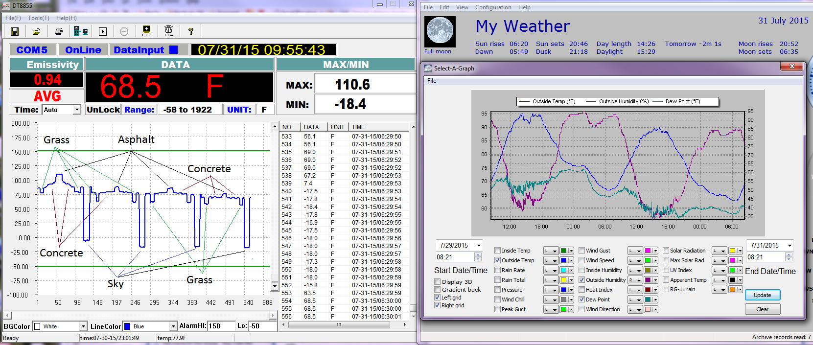
And these swings are easily felt while riding a motorcycle as mentioned.
The slope in the temp of the concrete is from the shadow of the house moving down the sidewalk, by the time I took the first measurement the entire length of the front sidewalk was in shade to the asphalt driveway.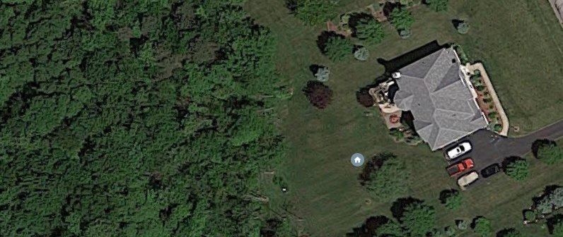
I start measuring from the front door, and then walk out to the driveway. The image is mostly E-W with east to the right.
I am surprised he got any cash to do this study. In the UK two people I know tried to get grants to do it and in one case a “better qualified applicant” got the grant instead even though better qualified equalled a lower class of degree from a low prestige ex poly. Both are no longer in the climate science field from total disillusionment as to its integrity.
The Lovin’ Spoonful
Summer in the City
SUMMER IN THE CITY
Hot town, summer in the city
Back of my neck getting dirty and gritty
Been down, isn’t it a pity
Doesn’t seem to be a shadow in the city
All around, people looking half dead
Walking on the sidewalk, hotter than a match head
But at night it’s a different world
Go out and find a girl
Come-on come-on and dance all night
Despite the heat it’ll be alright
And babe, don’t you know it’s a pity
That the days can’t be like the
nights
In the summer, in the city
In the summer, in the city
Cool town, evening in the city
Dressing so fine and looking so pretty
Cool cat, looking for a kitty
Gonna look in every corner of the city
Till I’m wheezing like a bus stop
Running up the stairs, gonna meet you on the rooftop
But at night it’s a different world
Go out and find a girl
Come-on come-on and dance all night
Despite the heat it’ll be alright
And babe, don’t you know it’s a pity
That the days can’t be like the
nights
In the summer, in the city
In the summer, in the city
Hot town, summer in the city
Back of my neck getting dirty and gritty
Been down, isn’t it a pity
Doesn’t seem to be a shadow in the city
All around, people looking half
dead
Walking on the sidewalk, hotter than a match head
But at night it’s a different world
Go out and find a girl
Come-on come-on and dance all night
Despite the heat it’ll be alright
And babe, don’t you know it’s a pity
That the days can’t be like the
nights
In the summer, in the city
In the summer, in the city
Unsolved Environ Mental Problem 40+ ys.