
Guest essay by Eric Worrall
h/t IceAgeNow – seismologist Chris Goldfinger has warned that a gigantic Earthquake, just off the coast of the Pacific Northwest, with the potential to kill over 10,000 American people, is many decades overdue.
According to The New Yorker;
San Andreas, which runs nearly the length of California and is perpetually rumored to be on the verge of unleashing “the big one.” That rumor is misleading, no matter what the San Andreas ever does. Every fault line has an upper limit to its potency, determined by its length and width, and by how far it can slip. For the San Andreas, one of the most extensively studied and best understood fault lines in the world, that upper limit is roughly an 8.2—a powerful earthquake, but, because the Richter scale is logarithmic, only six per cent as strong as the 2011 event in Japan.
Just north of the San Andreas, however, lies another fault line. Known as the Cascadia subduction zone, it runs for seven hundred miles off the coast of the Pacific Northwest, beginning near Cape Mendocino, California, continuing along Oregon and Washington, and terminating around Vancouver Island, Canada. The “Cascadia” part of its name comes from the Cascade Range, a chain of volcanic mountains that follow the same course a hundred or so miles inland. The “subduction zone” part refers to a region of the planet where one tectonic plate is sliding underneath (subducting) another. Tectonic plates are those slabs of mantle and crust that, in their epochs-long drift, rearrange the earth’s continents and oceans. Most of the time, their movement is slow, harmless, and all but undetectable. Occasionally, at the borders where they meet, it is not.
Read more: http://www.newyorker.com/magazine/2015/07/20/the-really-big-one
The Earthquake and tsunami are not the only problems which victims of the coming Earthquake will face. According to The New Yorker, Fifteen per cent of Seattle is built on liquefiable land, including seventeen day-care centers and the homes of some thirty-four thousand five hundred people. . Liquefiable land is exactly what it sounds like – during a strong Earthquake it temporarily turns to a liquid similar to quicksand. Anything solid simply sinks into the ground.
The odds of a major in the next 50 years are estimated as one in three, or a “full rupture”, which would generate a magnitude 9+ Earthquake just off the coast of the Western seaboard, as one in ten.
In the wake of the devastating 2011 Japan Earthquake, Japan has been busy deploying Earthquake early warning sensors throughout the country. Earthquakes create non destructive “P waves“, which can be detected ahead of the main quake, providing a few minutes warning.
The following Fox News interview claims there is no budget to deploy a Japanese style early warning system in the Seattle area, or any of the other regions at risk from the Cascadia fault – perhaps local government departments are too busy writing “global warming impact” studies, to give attention to Earthquake risks.
http://video.foxnews.com/v/video-embed.html?video_id=4356513070001According to the video, if a full rupture Earthquake strikes, everything West of Interstate 5 will be “toast”.
The last time the Cascadia fault produced a major Earthquake was in 1700, and there is evidence of 41 similar events occurring roughly every 240 years, stretching back over the last 10,000 years, so there is strong historical evidence that this is a real and present danger to the citizens of the American Northwest. The next Earthquake is at least 60 years overdue.
Has anyone noticed that insurance payout costs for seismic events are rising?
Surely proof of “extreme seismicity”.
As we all know, insurance costs are the new perfect barometer of all global trends.
At least, they are, if you are an idiot.
It is a very sobering thing. But the Ghost forest, numerous tsunami deposits, mud volcanoes in Richmond, BC….all point to some violent activity on Cascadia in 1700. You can say “Claim” about its overdue status, but the facts remain: it will release again, and with catastrophic result. Of that we can be certain.
Compare THAT to the unicorns of Climate Science.
“Liquefiable land is exactly what it sounds like – during a strong Earthquake it temporarily turns to a liquid similar to quicksand. Anything solid simply sinks into the ground.”
As someone who has had the misfortune to see “liquifaction” first hand, the above is a pretty poor description, at least for the examples I saw.
In my case, the shaking, (and we had Ground Accelerations of over 3 G’s which is among the highest ever recorded let alone recorded under a city), caused the solids to sink and all the moisture was squeezed up to the surface and caused flooding. I saw things that were less dense than the silt/sand also squeezed up,including water sewers/pipes etc.although it could be that the utilities did not move and the silts and road moved down.. River banks liquified and slumped towards rivers. Saw a quite a few buildings that had foundation probs but none that actually sunk completely out of sight. Some of the sink holes in the roads were big enough to trap cars though.
Cheers
Roger
http://www.rogerfromnewzealand.wordpress.com
PS the boat in the pic looks more like a large pleasure yacht than a Japanese fishing boat.
If memory serves, in addition to several 500 year gaps in that record, the last 4 earthquakes average out at a little over 300 years. The article above leaves out one of the more significant factors mentioned in the original article – the sudden drop of 1-2 meters with respect to sea level that will accompany the quake. This is why in Japan the 10 meter tsunami overwhelmed a 10 meter sea wall. The sudden release of pressure meant that the coast of Japan dropped 1-1.5 meters with respect to sea level so as a result the top of the 10 meter sea wall was reduced to 8.5 meters above sea level. Despite this, where they were built those walls still deflected most of the energy of the tsunami. Sadly, here in the Pacific North West, such precautions do not exist.
Overdue?
Are earthquakes run on a periodic frequency, a clockwork seismology?
This is realistic. It is expected that it can happen.
But it’s not expected to happen at any particular time.
The 1700 Cascadia quake was dated from Japanese records and travel time of the tsunami across the Pacific:
http://pnsn.org/outreach/native-american-stories/Dating_the_1700_Cascadia_Earthquake_Great-2Ludwin.pdf
“The exact date and approximate time of the most recent CSZ earthquake, 9 PM on 26 January 1700, were determined from Japanese historic records of a tsunami arriving with no reports of associated shaking (Satake et al., 1996). The year was confirmed through close study of tree-ring patterns of ghost cedar roots (Yamaguchi et al., 1997). The magnitude estimate of 9.0 implies rupture along the entire length of the CSZ (Satake et al., 2003).”
The 10,000 deaths you mention is the estimate for Oregon alone, based on the assumption that Cascadia happens in February when most people are in their homes. A “full rupture” Cascadia event affects everywhere from the Mendocino Triple Junction in northern California to Vancouver, BC. Thousands more will die elsewhere.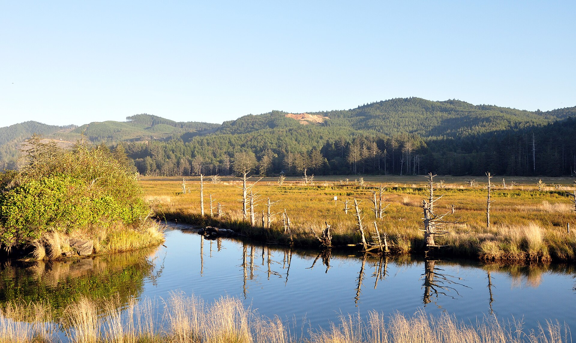
If Cascadia struck on a sunny summer weekend then 10,000 could die in Seaside, Oregon alone because of it’s unique geology. An early warning system will not be much good. Coastal residents will only have about 15 minutes or so from the time the earthquake hits and the tsunami arrives. The best coastal residents can do is to have a tsunami escape plan before the quake hits.
Fortunately, the State of Oregon has already done about all possible to help Oregonians prepare. It’s called the Oregon Resiliency Plan.
The Oregon Department of Mineral and Industries (DOGAMI), where Chris Goldfinger works and the DOGAMI team works, have created exceptionally detailed maps of the the entire Oregon coast tsunami danger zones.
From those detailed maps, the State of Oregon installed marked tsunami escape routes all along Oregon’s coast. The state also created an online tool that any coastal resident can enter their home address and it will build a customized escape route for them out of the danger zone.
Even 315 years later, the effects of the Great Cascadia Earthquake of 1700 are still apparent along Oregon/Washington coastal rivers and estuaries:
The dead snags seen in this picture are the remains of a coast forest that sank about 8 feet or so during that quake and got inundated by salt water, which both killed and preserved the trees. Called “ghost forests” these can be found all along the Oregon/Washington coasts.
I wrote an article about Cascadia a couple years ago. It’s titled “Cascadia: Day of Destiny”:
https://informthepundits.wordpress.com/2013/04/25/cascadia-day-of-destiny/
Interesting article. My response is too long to put here and requires a lot of explanation so I’ve posted it on my blog: Could global warming be delaying the “Big one” earthquake (re WUWT)
Summary: In short, increasing temperatures could be delaying “the big one”.
Eric wrote: “The last time the Cascadia fault produced a major Earthquake was in 1700, and there is evidence of 41 similar events occurring roughly every 240 years, stretching back over the last 10,000 years, so there is strong historical evidence that this is a real and present danger to the citizens of the American Northwest. The next Earthquake is at least 60 years overdue.”
Many of the events involved only a partial rupture of the Cascade fault and weren’t as strong as the one in 1700. A weaker earthquake is “overdue”. Seismologists estimate a 15% chance of a full rupture within 50 years, producing an earthquake and tsunami similar to Tohoku in Japan in 2011.
Just what are people supposed to do with this information? Be scared?
…if a full rupture Earthquake strikes, everything West of Interstate 5 will be “toast”
This statement appears to be from an unnamed FEMA official. Anybody know who said it, and on what basis? It certainly wouldn’t be from the tsunami; there are whole mountain ranges between I-5 and the coast..
My friend in Bellingham sent me this – north of Seattle:
ger_ofr2004-15_tsunami_hazard_bellingham
“…if a full rupture Earthquake strikes, everything West of Interstate 5 will be “toast”
That is an exaggeration by the New Yorker, as most of the land west of I-5 is well above sea level…
In an otherwise excellent and chilling article – the author HAD to insert this remark to establish her self-loathing bonafides: “It does not speak well of European-Americans that such stories counted as evidence for a proposition only after that proposition had been proved.” I’d love her to give ONE example of ANYTHING that “speaks well” of the people that explored and settled this great and prosperous land.
Microsoft would be flooded, which will be an issue, especially as we have our oldest working there. Yet another reason to scout out that escape route to Canada through the mountains.
I can’t seem to find it, but there is an island off the West coast of Africa, that if it splits, and it will do one day, will cause a tsunami that will destroy large sections of the east coast of America.
ho hum
Aalto university helps Quileute nation relocate after whales warn of impending tsunami.
http://gradsage.com/2015/04/15/aalto-university-helps-quileute-nation-relocate-after-whales-warn-of-impending-tsunami/
“Being a petroleum geophysicist, I prefer the explanation that S&G [Soddom and Gomorrah] went up in flames from a natural gas leak via fault rupture, ignited by open flame and fires. I can’t explain the pillar of salt. But the fireball has an all too real source.”
I can explain the pillar of salt: currency. Salt poured into small deep holes, dissolved into solution, compressed with heavy poles, let dry then lifted out of the ground as a crystalline “pillar” — was a densest and preferred method for transport. Salt pillars were ingots of desert currency.
I believe Lot sold his wife into slavery and the pillar was payment. Perhaps he did it because he had an incestuous relationship with his daughters, which was amply documented (and their progeny clumsily explained) in a later chapter. Perhaps the wife — whose actual name was scrubbed from the record by the same re-write committee — merely did not approve.
Earthquakes are notoriously bad at time keeping and we are notoriously bad at reality preparation. The wastage of monies on crap climate research would be better spent on increasing earthquake knowledge and mitigation.
The article states that …”because the Richter scale is logarithmic,” a Richter 8.2 quake is “six per cent as strong as the 2011 event in Japan,” which was 9.0. Well, 10^9 / 10^8.2 = 6.31, so the 8.2 quake would be 1 / 6.31 or ~15.8% the strength of a 9.0 quake.
Regarding the ‘pillar of salt’, consider these remarkable photos of calcified animals by Lake Natron in Tanzania.
http://www.huffingtonpost.com/2013/10/03/calcified-animals_n_4032659.html
I’m no geologist, but perhaps in the aftermath of an earthquake, something similar might have occurred at the edge of the Dead Sea, and Lot’s wife could have been one of those unfortunate enough to be caught up in it ?
See response resources on the Cascadia fault, especially the
Cascadia Region Earthquake Workgroup
http://www.crew.org/
I attended a civil defense special conference in Ashland, Oregon in 2000. We were told that because a magnitude 9 earthquake along the Cascadia subduction zone would affect two major metropolitan areas at once, small towns in western Oregon and Washington should plan to be without outside aid for as long as six months. I live on far more stable crust now.
Gosh. What if all those millions of tax and spend progressives now living in cities from San Francisco to Seattle try to relocate? They’ll turn everywhere else in the west into “Portlandia.” OMG!