The climate zealots were out in force this week trying to link the rains in Texas to ‘climate change’. The press release from NASA makes no such connections, but instead blames a mundane weather pattern induced by El Niño. Video and explanatory graphic follows.

Credits: Images produced by Hal Pierce (SSAI/NASA GSFC)
From NASA/Goddard Space Flight Center:
Severe flooding hits central Texas, Oklahoma
A stagnant upper-air pattern that spread numerous storms and heavy rains from central Texas up into Oklahoma has resulted in record flooding for parts of the Lone Star State. One of the hardest hit areas was in Hays County Texas south of Austin where the Blanco River rose rapidly and set a new record crest at over 40 feet, 13 feet above flood stage, following a night of very heavy rain in the area, with over 12 inches reported locally in a short period of time, in an area already wet from previous storms. The combination of high pressure over the southeastern United States and a persistent southerly flow of moisture up out of the Gulf of Mexico ahead of a deep upper-level trough that was slow to leave the central and southern Rockies set the stage for persistent widespread storms across the Southern Plains from the eastern half of Texas, through Oklahoma, and into southern Kansas.
The Integrated Multi-satellitE Retrievals for GPM, known simply as IMERG, is a new rainfall product that produces estimates of precipitation from a combination of passive microwave sensors, including the GMI microwave sensor onboard the GPM satellite, and geostationary IR (infrared) data. This first image shows IMERG rainfall estimates for the week-long period 19 to 26 May 2015 for the south central US. IMERG shows upwards of 200 mm of rain (~8 inches, orange and red areas) across central and southeastern Texas and a large portion of Oklahoma with locally higher amounts exceeding 300 mm (~12 inches, shown in brown) in central Texas and 400 mm (~16 inches, purple areas) over south central Oklahoma, where early in the period a stationary front provided the focus for storms. So far at least 18 fatalities are being blamed on the recent flooding across the region.
The recent rains drove monthly average rainfall totals well in access [sic] of the seasonal averages for this period. The panel on the right shows the current monthly TRMM-based average rainfall (which has a much longer climatology than IMERG) is well above the typical amount (shown in blue) for this time of year across most of the eastern two thirds of Texas and almost all of Oklahoma.

The northern Gulf Coast also has above normal rainfall (shown in green) while at the same time the Tennessee and Ohio Valleys are showing below normal rainfall (yellow area). This type of pattern along with the excessive rainfall anomalies evident over the eastern equatorial Pacific offers a strong clue as to a potential culprit–El Nino. Anomalous rainfall over the eastern equatorial Pacific with alternating areas of above and below normal rainfall extending into midlatides is a classic El Nino teleconnection pattern. Rainfall anomalies were somewhat similar for this same time last year (left panel), but although there was an inkling, El Nino failed to materialize. This year El Nino appears to be alive and well.
Video:
TRMM/GPM are a joint missions between NASA and the Japanese space agency JAXA.
Images produced by Hal Pierce (SSAI/NASA GSFC) and caption by Steve Lang (SSAI/NASA GSFC).
###
Show this to the climate zealots, also from NASA and NOAA:

Source: http://www.nasa.gov/centers/goddard/news/topstory/2008/elnino_winter.html
I might have thought that at least some commenters in the MSM might have mentioned the good news that the drought in West Texas is considerably diminished by now.
Gee, I wonder how well NOAA predicted a record wet May for Texas and Oklahoma?
Here is their April-May-June prediction from April 2015 from the web.archive, parent page:
http://www.cpc.ncep.noaa.gov/products/predictions/multi_season/13_seasonal_outlooks/color/churchill.php
I’d call it a miss.
Full image URL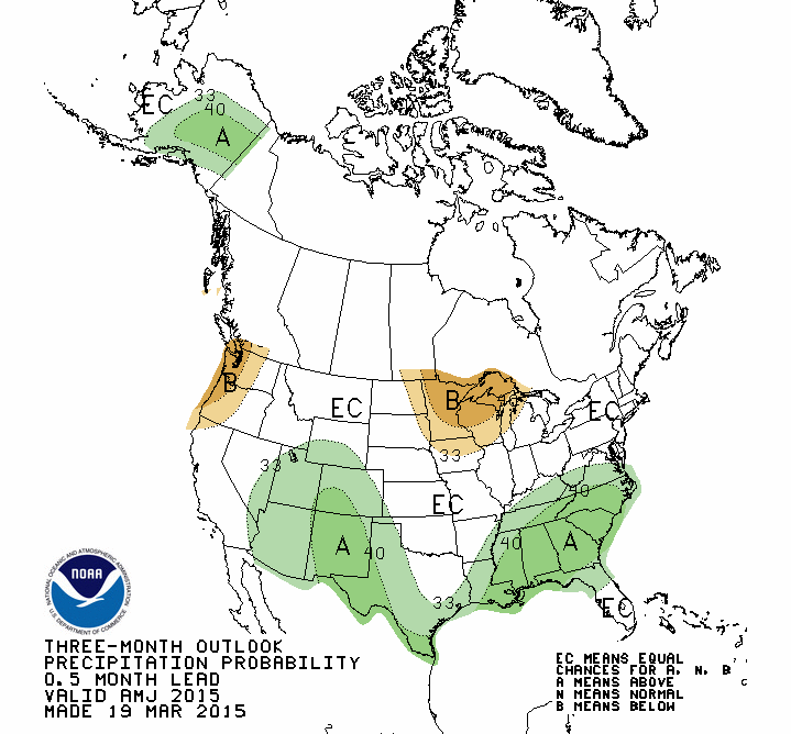
Here is a link to a photo of a comparison NOAA 60-day Precipitation Percent of Normal map for the US captured on May 29, 2015. ?oh=dd498abb7336e2c7d94ce3ad51eae2da&oe=55FA4964
Clearly they underestimated the effects of climate change and its unpredictable effect on extreme weather events, lol.
Reblogged this on ajmarciniak.
Last year, weren’t the warmest predicting a state of permanent drought in Texas because of climate change?
Date Tahiti Darwin Daily** 30 day avg SOI 90 day avg SOI
9 May 2015 1007.45 1012.05 -46.90 -6.16 -5.66
10 May 2015 1008.21 1012.45 -44.10 -7.47 -6.13
11 May 2015 1009.50 1013.25 -40.40 -8.87 -6.55
12 May 2015 1010.49 1013.55 -35.10 -10.11 -6.80
13 May 2015 1011.28 1013.85 -31.30 -11.21 -7.01
14 May 2015 1012.51 1014.60 -27.70 -12.34 -7.29
15 May 2015 1012.95 1015.75 -33.10 -13.65 -7.69
16 May 2015 1012.22 1014.65 -30.30 -14.36 -8.08
17 May 2015 1011.86 1013.30 -22.70 -14.71 -8.35
18 May 2015 1011.20 1012.90 -24.70 -15.34 -8.73
19 May 2015 1011.60 1013.15 -23.50 -16.02 -9.19
20 May 2015 1014.42 1013.30 -3.10 -16.18 -9.41
21 May 2015 1014.86 1014.20 -6.60 -16.05 -9.75
22 May 2015 1014.25 1014.35 -12.40 -16.09 -10.16
23 May 2015 1013.96 1014.75 -17.70 -16.49 -10.48
24 May 2015 1015.22 1014.10 -3.10 -16.80 -10.41
25 May 2015 1016.86 1014.60 5.60 -16.95 -10.20
26 May 2015 1016.19 1014.75 -0.60 -17.10 -9.96
27 May 2015 1015.45 1013.30 4.70 -16.62 -9.77
28 May 2015 1016.08 1012.25 17.60 -15.52 -9.55
29 May 2015 1016.42 1012.65 17.10 -14.31 -9.39
Recent (preliminary) Southern Oscillation Index (SOI) values
Tahiti = Barometric pressure (daily reading)
Darwin = Barometric pressure (daily reading)
30 day Av.SOI = Average daily SOI value for the previous 30 days.
90 day Av.SOI = Average daily SOI value for the previous 90 days.
https://www.longpaddock.qld.gov.au/seasonalclimateoutlook/southernoscillationindex/30daysoivalues/
I’ve noticed that over the past 12 months or so there is very little reference to ‘climate change’ in weather reports in the Australian press. It used to be that the last paragraph on most reports of floods/droughts/storms/etc had the obligatory reference to CAGW or ‘as predicted by climate models’ or the like.
Has the press finally taken notice of the ‘pause’?
Probably because of all the inconvenient milder, cooler and wetter weather we’ve been having in Oz recently. Best just keep quiet about it. I think there is still a small part of the desert/farmland in West South Queendland that are still in “the worst drought evah”, but even that is a shrinking zone.
El Niño is the same as a year ago. But AMO down sharply.
[snip REN for the gazilionth time, STOP POPSTING URLS WITH NO EXAPLANTAION!!!!!!!!! This is why you are moderation, thread bombing IRLs constantly. I know you mean well, but you need to explain why people should look at something- Anthony ]
In the context of intermittent weak El Niño conditions over the last year, this section features a comparison figure with similar weak events, excluding prolonged “Year-2” El Niño conditions. It appears that the situation will become more clear-cut by mid-2015, so that a larger sample of comparable events can be chosen.
http://www.esrl.noaa.gov/psd/enso/mei/#discussion
no mention?
It must have been implied in that case.
The current position of the jetstream looks like the La Nina pattern given above (look at Accuweather).
The Texas/ Oklahoma big rain event is more likely just weather, and people are jumping the gun on El Nino.
To quote from the post:
“Rainfall anomalies were somewhat similar for this same time last year (left panel), but although there was an inkling, El Nino failed to materialize. This year El Nino appears to be alive and well.”
In spite of predictions of a super El Nino last year the “Spring Prediction break ” fooled most predictors.
Texas has been a test bed for weapons testing sense the late 40’s and early 50’s http://en.wikipedia.org/wiki/Nuclear_weapons_testing They didn’t care about their people then and I’m sure they don’t care now http://allnewspipeline.com/Texas_Under_Attack_Resisting_Jade_Helm.php
http://allnewspipeline.com/Jade_Helm_2015.php
Burrowing deep into the skin of a host is what man does, so is he living the life of a parasite? http://dictionary.reference.com/browse/parasite
jmorpuss
You are losing your credibility citing wikipedia for that.
??? Hundreds of Nuke weapons were tested in Nevada, a couple over a few Pacific islands, a few off of the CA coast (ASW weapons, for example). One or two up north. Texas? They only built (assembled) the cores there.
Isn’t Nevada a city of the state called Texas ?
[They’re both states. ~mod.]
Thanks Mod , Is this info not correct? And when did Nevada become a state ?
The City of Nevada is located two miles east of Lavon Lake in southeastern Collin County in the great state of Texas. http://www.cityofnevadatx.org/home.htm
[Reply: All that info can be found wth a simple search. ~mod.]
Cheers Mod Found the state of Nevada where the nuclear tests were, They were not carried out in the state of Texas as I may of misled some to believe. But here are a few things that should concern all Texans http://www.agriculturedefensecoalition.org/content/texas-issues-weather-modification .
The first atomic bomb test in the United “States was in New Mexico.
Naaa. This isn’t caused by CO2 or natural intrinsic variations brought about by El Nino conditions. This is solar doncha know.
Sigh.
The updated (March-April) MEI has risen by 0.30 standard deviations to +0.95, for a strongly increased ranking, now crossing over the ‘strong’ El Niño threshold (upper 10%). Something similar happened last year when the MEI peaked in April-May 2014 with +0.93, only to drop back in subsequent months.
If you live on a flood plain, ask yourself: how was this flood plain formed? It may not flood every year but sooner or later it will flood a lot. So expect a healthy jump in insurance premiums or no insurance at all.